
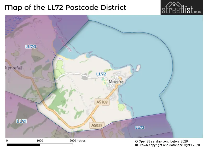
Map of the Postcode District
Explore the postcode district by using our interactive map.
Circles represent recorded crime; the larger the circle, the higher the crime rates.
Your support helps keep this site running!
If you enjoy using this website, consider buying me a coffee to help cover hosting costs.
The postcode district located in the LL Llandudno postal area , LL72 has a population of 705 residents according to the 2021 England and Wales Census.
The area of the district is 1.80 square miles (4.67 square kilometers or 1,153.18 acres).
Where is the LL72 District?
To give you an idea where the district is located we have created the following table showing nearby towns.
Nearest Towns to LL72
| Town | Distance (miles) | Direction |
|---|---|---|
| Amlwch | 5.73 | NW |
| Llangefni | 7.00 | SSW |
| Beaumaris | 8.85 | SE |
| Menai Bridge | 9.32 | SSE |
| Bangor | 9.84 | SSE |
| Llanfairfechan | 13.28 | ESE |
| Bethesda | 14.16 | SSE |
| Caernarfon | 14.51 | S |
| Penmaenmawr | 14.74 | ESE |
| Holyhead | 16.03 | W |
| Llandudno | 17.48 | E |
| Rhosgadfan | 18.00 | S |
| Conwy | 18.07 | ESE |
| Colwyn Bay | 22.91 | E |
| Llanrwst | 23.81 | SE |
| Betws-y-Coed | 25.79 | SE |
| Blaenau Ffestiniog | 27.87 | SSE |
| Abergele | 28.01 | E |
| Porthmadog | 29.71 | S |
| Criccieth | 29.80 | S |
The post town for this district is MOELFRE.
Postcode Information for District LL72 (Total Geographical Postcodes: 44)
Retail and Shopping in LL72
Street
Town
Locality
Number of Shops
Central Postcode
View on Google Maps
MOELFRE
6
LL72 8HL
View on Google Maps
| Street | Town | Locality | Number of Shops | Central Postcode | View on Google Maps |
|---|---|---|---|---|---|
| MOELFRE | 6 | LL72 8HL | View on Google Maps |
The primary settlement in the LL72 postcode district is Moelfre, located in the county of Gwynedd in Wales. There are also some other significant settlements in this district, including Llanallgo. The main post town in this district is Moelfre.
When it comes to local government, postal geography often disregards political borders. However, this district intersects the following councils: the district mostly encompasses the Sir Ynys Mon - Isle of Anglesey area with a total of 44 postal codes.
The largest settlement in the LL72 postal code is MOELFRE followed by MARIANGLAS, and LLANALLGO.
The postcode area has a boundary with The Irish Sea.
The LL72 Postcode shares a border with LL73 (MARIANGLAS, TRAETH BYCHAN) and LL70 (DULAS).
Postcode Sectors


Stations in the Sector
No stations found in this postcode district.
Accessable Motorway Junctions
No Motorway Junctions Accessable from this postcode district.
Weather Forecast for Moelfre (Beach)
| Time Period | Icon | Description | Temperature | Rain Probability | Wind |
|---|---|---|---|---|---|
| 12:00 to 15:00 | Partly cloudy (day) | 14.0°C (feels like 12.0°C) | 1.00% | WSW 9 mph | |
| 15:00 to 18:00 | Partly cloudy (day) | 14.0°C (feels like 12.0°C) | 1.00% | WSW 9 mph | |
| 18:00 to 21:00 | Partly cloudy (night) | 11.0°C (feels like 10.0°C) | 1.00% | SSW 9 mph | |
| 21:00 to 00:00 | Partly cloudy (night) | 11.0°C (feels like 9.0°C) | 1.00% | SSW 9 mph |
| Time Period | Icon | Description | Temperature | Rain Probability | Wind |
|---|---|---|---|---|---|
| 00:00 to 03:00 | Cloudy | 12.0°C (feels like 10.0°C) | 12.00% | SSW 11 mph | |
| 03:00 to 06:00 | Cloudy | 12.0°C (feels like 10.0°C) | 6.00% | SSW 11 mph | |
| 06:00 to 09:00 | Cloudy | 12.0°C (feels like 10.0°C) | 4.00% | SSW 11 mph | |
| 09:00 to 12:00 | Cloudy | 13.0°C (feels like 11.0°C) | 5.00% | SSW 13 mph | |
| 12:00 to 15:00 | Cloudy | 14.0°C (feels like 11.0°C) | 4.00% | SSW 16 mph | |
| 15:00 to 18:00 | Cloudy | 14.0°C (feels like 11.0°C) | 4.00% | SSW 16 mph | |
| 18:00 to 21:00 | Cloudy | 13.0°C (feels like 10.0°C) | 4.00% | S 16 mph | |
| 21:00 to 00:00 | Cloudy | 13.0°C (feels like 10.0°C) | 6.00% | S 18 mph |
| Time Period | Icon | Description | Temperature | Rain Probability | Wind |
|---|---|---|---|---|---|
| 00:00 to 03:00 | Cloudy | 12.0°C (feels like 9.0°C) | 4.00% | S 18 mph | |
| 03:00 to 06:00 | Cloudy | 12.0°C (feels like 9.0°C) | 3.00% | S 18 mph | |
| 06:00 to 09:00 | Cloudy | 13.0°C (feels like 9.0°C) | 4.00% | S 20 mph | |
| 09:00 to 12:00 | Cloudy | 13.0°C (feels like 10.0°C) | 4.00% | S 22 mph | |
| 12:00 to 15:00 | Overcast | 15.0°C (feels like 11.0°C) | 8.00% | S 22 mph | |
| 15:00 to 18:00 | Overcast | 15.0°C (feels like 12.0°C) | 14.00% | S 20 mph | |
| 18:00 to 21:00 | Light rain | 15.0°C (feels like 11.0°C) | 56.00% | S 18 mph | |
| 21:00 to 00:00 | Light rain | 14.0°C (feels like 11.0°C) | 57.00% | SSW 18 mph |
| Time Period | Icon | Description | Temperature | Rain Probability | Wind |
|---|---|---|---|---|---|
| 00:00 to 03:00 | Light rain | 13.0°C (feels like 10.0°C) | 50.00% | SW 16 mph | |
| 03:00 to 06:00 | Light rain shower (night) | 12.0°C (feels like 10.0°C) | 34.00% | SW 13 mph | |
| 06:00 to 09:00 | Light rain shower (night) | 11.0°C (feels like 8.0°C) | 38.00% | SW 16 mph | |
| 09:00 to 12:00 | Light rain shower (day) | 11.0°C (feels like 8.0°C) | 39.00% | SW 16 mph | |
| 12:00 to 15:00 | Light rain shower (day) | 12.0°C (feels like 9.0°C) | 39.00% | SW 18 mph | |
| 15:00 to 18:00 | Partly cloudy (day) | 12.0°C (feels like 9.0°C) | 15.00% | WSW 16 mph | |
| 18:00 to 21:00 | Partly cloudy (night) | 11.0°C (feels like 8.0°C) | 11.00% | NW 13 mph | |
| 21:00 to 00:00 | Cloudy | 11.0°C (feels like 8.0°C) | 11.00% | W 13 mph |
| Time Period | Icon | Description | Temperature | Rain Probability | Wind |
|---|---|---|---|---|---|
| 00:00 to 03:00 | Partly cloudy (night) | 10.0°C (feels like 8.0°C) | 11.00% | W 13 mph | |
| 03:00 to 06:00 | Light rain shower (night) | 11.0°C (feels like 8.0°C) | 42.00% | WSW 16 mph | |
| 06:00 to 09:00 | Light rain | 11.0°C (feels like 8.0°C) | 52.00% | WSW 16 mph | |
| 09:00 to 12:00 | Light rain | 12.0°C (feels like 9.0°C) | 52.00% | SW 16 mph | |
| 12:00 to 15:00 | Light rain | 12.0°C (feels like 9.0°C) | 52.00% | SW 18 mph | |
| 15:00 to 18:00 | Light rain shower (day) | 13.0°C (feels like 10.0°C) | 38.00% | WSW 18 mph | |
| 18:00 to 21:00 | Clear night | 12.0°C (feels like 9.0°C) | 10.00% | W 16 mph | |
| 21:00 to 00:00 | Partly cloudy (night) | 12.0°C (feels like 9.0°C) | 8.00% | W 16 mph |
| Postal Sector | Delivery Office |
|---|---|
| LL72 8 | Llangefni Delivery Office |
| L | L | 7 | 2 | - | X | X | X |
| L | L | 7 | 2 | Space | Numeric | Letter | Letter |
Street List for the LL72 District
Current Monthly Rental Prices
| # Bedrooms | Min Price | Max Price | Avg Price |
|---|---|---|---|
| 3 | £850 | £850 | £850 |
Current House Prices
| # Bedrooms | Min Price | Max Price | Avg Price |
|---|---|---|---|
| 2 | £385,000 | £385,000 | £385,000 |
| 3 | £235,000 | £450,000 | £361,429 |
| 4 | £415,000 | £700,000 | £561,250 |
| 6 | £650,000 | £650,000 | £650,000 |
| 7 | £550,000 | £550,000 | £550,000 |
| 16 | £650,000 | £650,000 | £650,000 |
Estate Agents
| Logo | Name | Brand Name | Address | Contact Number |
|---|---|---|---|---|
 | Menai Bridge | Beresford Adams | 15 High Street, Menai Bridge, Anglesey, Gwynedd, LL59 5EE | 01248 661250 |
 | Benllech | Egerton Estates | The Property Centre, Padworth House, Benllech, Anglesey, LL74 8TF | 01248 663122 |
 | Benllech | Anglesey Property Company | Bangor Road Benllech LL74 8TR | 01248 663141 |
 | Covering Nationwide | The Agency UK | Covering Nationwide | 020 3909 1509 |
 | Llangefni | Dafydd Hardy | 3 Sgwar Bulkeley Llangefni Ynys M�n LL77 7LR | 01248 661234 |
Yearly House Price Averages for the District
| Type of Property | 2018 Average | 2018 Sales | 2017 Average | 2017 Sales | 2016 Average | 2016 Sales | 2015 Average | 2015 Sales |
|---|---|---|---|---|---|---|---|---|
| Detached | £274,448 | 20 | £232,375 | 8 | £179,300 | 5 | £200,808 | 13 |
| Semi-Detached | £257,500 | 2 | £70,000 | 1 | £137,000 | 1 | £115,000 | 1 |
| Terraced | £190,400 | 5 | £140,780 | 5 | £203,000 | 5 | £140,900 | 5 |
| Flats | £0 | 0 | £0 | 0 | £0 | 0 | £0 | 0 |