The LL57 postcode district is a postal district located in the LL Llandudno postcode area with a population of 26,843 residents according to the 2021 England and Wales Census.
The area of the LL57 postcode district is 43.26 square miles which is 112.04 square kilometres or 27,685.38 acres.
Currently, the LL57 district has about 894 postcode units spread across 4 geographic postcode sectors.
Given that each sector allows for 400 unique postcode combinations, the district has a capacity of 1,600 postcodes. With 894 postcodes already in use, this leaves 706 units available.
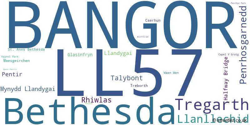
The largest settlement in the LL57 postal code is BANGOR followed by Bethesda, and PENRHOSGARNEDD.
The postcode area has a boundary with The Irish Sea and Menai Strait.
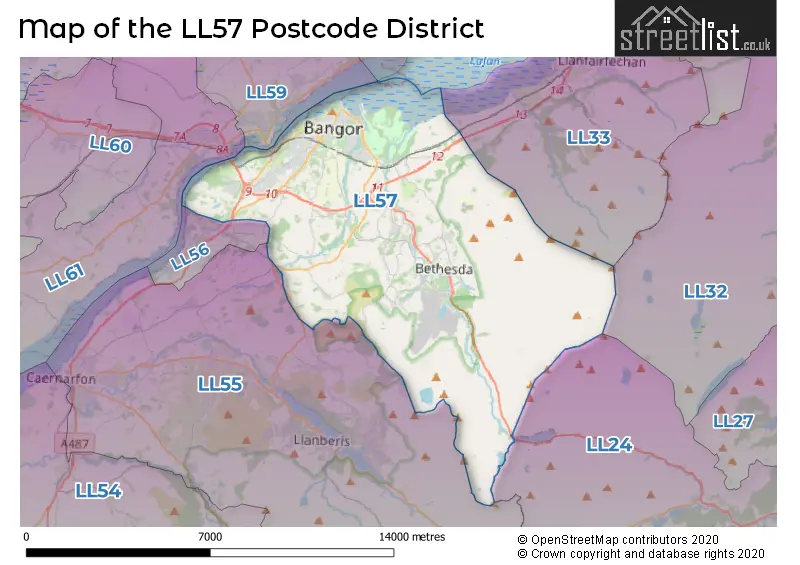
The LL57 Postcode shares a border with LL24 (BETWS Y COED, PENMACHNO, PENTREFOELAS) and LL55 (CAERNARFON, LLANBERIS, LLANRUG).
The primary settlement in the LL57 postcode district is Bangor, located in Gwynedd, Wales. The most significant post town in this district is also Bangor. Additionally, there are other significant settlements in the district, including Bethesda, Capel Y Graig, Penrhosgarnedd, Treborth, Caerhun, Glasinfryn, Halfway Bridge, Llandygai, Minffordd, Mynydd Llandygai, Penrhyn Park, Pentir, Rhiwlas, St. Anns Bethesda, Tregarth, Vaynol Park, Waen Pentir, and Waen Wen.
For the district LL57, we have data on 5 postcode sectors. Here's a breakdown: The sector LL57 1, covers Bangor in Gwynedd. The sector LL57 2, covers Bangor and Penrhosgarnedd in Gwynedd. The sector LL57 3, covers Bethesda and Llanllechid in Gwynedd. The sector LL57 4, covers Bangor and Tregarth in Gwynedd. The sector LL57 9 is non-geographic. It's often designated for PO Boxes, large organisations, or special services.

Map of the LL57 Postcode District
Explore the LL57 postcode district by using our free interactive map.
When it comes to local government, postal geography often disregards political borders. However, for a breakdown in the LL57 District: the district mostly encompasses the Gwynedd - Gwynedd area with a total of 901 postcodes.
Recent House Sales in LL57
| Date | Price | Address |
|---|---|---|
| 19/10/2023 | £148,000 | Orme Terrace, Bangor, LL57 2YT |
| 13/10/2023 | £305,000 | Bron Y De, Bangor, LL57 4TL |
| 12/10/2023 | £167,500 | Carneddi Road, Bethesda, Bangor, LL57 3SG |
| 10/10/2023 | £245,000 | Pentir, Bangor, LL57 4YA |
| 09/10/2023 | £81,000 | Holyhead Road, Bangor, LL57 2HW |
| 09/10/2023 | £160,000 | Hill Street, Bangor, LL57 2HA |
| 06/10/2023 | £117,000 | High Street, Rhiwlas, Bangor, LL57 4EY |
| 29/09/2023 | £160,000 | Caernarfon Road, Bangor, LL57 4LN |
| 26/09/2023 | £193,000 | Carneddi Road, Carneddi, Bangor, LL57 3RY |
| 25/09/2023 | £113,750 | Water Street, Bangor, LL57 1BT |
Weather Forecast for LL57
Press Button to Show Forecast for Bethesda
| Time Period | Icon | Description | Temperature | Rain Probability | Wind |
|---|---|---|---|---|---|
| 03:00 to 06:00 | Clear night | 4.0°C (feels like 2.0°C) | 1.00% | SE 4 mph | |
| 06:00 to 09:00 | Sunny day | 4.0°C (feels like 2.0°C) | 2.00% | ESE 4 mph | |
| 09:00 to 12:00 | Sunny day | 7.0°C (feels like 5.0°C) | 2.00% | E 7 mph | |
| 12:00 to 15:00 | Cloudy | 8.0°C (feels like 5.0°C) | 7.00% | NE 9 mph | |
| 15:00 to 18:00 | Partly cloudy (day) | 8.0°C (feels like 6.0°C) | 6.00% | NE 9 mph | |
| 18:00 to 21:00 | Sunny day | 7.0°C (feels like 5.0°C) | 5.00% | NE 7 mph | |
| 21:00 to 00:00 | Partly cloudy (night) | 5.0°C (feels like 3.0°C) | 4.00% | ENE 4 mph |
Press Button to Show Forecast for Bethesda
| Time Period | Icon | Description | Temperature | Rain Probability | Wind |
|---|---|---|---|---|---|
| 00:00 to 03:00 | Partly cloudy (night) | 3.0°C (feels like 2.0°C) | 4.00% | E 4 mph | |
| 03:00 to 06:00 | Partly cloudy (night) | 3.0°C (feels like 2.0°C) | 5.00% | ESE 4 mph | |
| 06:00 to 09:00 | Sunny day | 4.0°C (feels like 3.0°C) | 5.00% | E 2 mph | |
| 09:00 to 12:00 | Partly cloudy (day) | 8.0°C (feels like 6.0°C) | 5.00% | ENE 7 mph | |
| 12:00 to 15:00 | Cloudy | 9.0°C (feels like 7.0°C) | 11.00% | ENE 9 mph | |
| 15:00 to 18:00 | Cloudy | 9.0°C (feels like 7.0°C) | 15.00% | NE 9 mph | |
| 18:00 to 21:00 | Cloudy | 8.0°C (feels like 6.0°C) | 11.00% | NE 9 mph | |
| 21:00 to 00:00 | Cloudy | 7.0°C (feels like 4.0°C) | 11.00% | NE 7 mph |
Press Button to Show Forecast for Bethesda
| Time Period | Icon | Description | Temperature | Rain Probability | Wind |
|---|---|---|---|---|---|
| 00:00 to 03:00 | Cloudy | 6.0°C (feels like 3.0°C) | 13.00% | ENE 9 mph | |
| 03:00 to 06:00 | Cloudy | 5.0°C (feels like 2.0°C) | 13.00% | NE 9 mph | |
| 06:00 to 09:00 | Cloudy | 6.0°C (feels like 3.0°C) | 14.00% | NNE 9 mph | |
| 09:00 to 12:00 | Cloudy | 8.0°C (feels like 5.0°C) | 15.00% | NNE 11 mph | |
| 12:00 to 15:00 | Cloudy | 9.0°C (feels like 6.0°C) | 17.00% | N 11 mph | |
| 15:00 to 18:00 | Cloudy | 10.0°C (feels like 7.0°C) | 15.00% | N 9 mph | |
| 18:00 to 21:00 | Sunny day | 9.0°C (feels like 7.0°C) | 10.00% | NNW 9 mph | |
| 21:00 to 00:00 | Clear night | 6.0°C (feels like 4.0°C) | 7.00% | WNW 7 mph |
Where is the LL57 Postcode District?
The postcode district LL57 is located in the town of Bangor. It is situated near several neighboring towns: Menai Bridge to the North West, Y Felinheli to the West, Beaumaris to the North, Llanfairfechan to the North East, and Trefriw to the East. The distance between Bangor and London is approximately 203.26 miles.
The district is within the post town of BANGOR.
The sector has postcodes within the nation of Wales.
The LL57 Postcode District is in the Gwynedd region of West Wales within the Wales.
| Postcode Sector | Delivery Office |
|---|---|
| LL57 1 | Bangor (ll) Delivery Office |
| LL57 2 | Bangor (ll) Delivery Office |
| LL57 3 | Bangor (ll) Delivery Office |
| LL57 4 | Bangor (ll) Delivery Office |
| L | L | 5 | 7 | - | X | X | X |
| L | L | 5 | 7 | Space | Numeric | Letter | Letter |
Tourist Attractions within the Postcode Area
We found 3 visitor attractions within the LL57 postcode area
| Felin Cochwillan Watermill |
|---|
| View Felin Cochwillan Watermill on Google Maps |
| Penrhyn Castle |
| View Penrhyn Castle on Google Maps |
| Storiel |
| View Storiel on Google Maps |
Current Monthly Rental Prices
| # Bedrooms | Min Price | Max Price | Avg Price |
|---|---|---|---|
| £1,500 | £1,500 | £1,500 | |
| 1 | £325 | £910 | £599 |
| 2 | £464 | £1,040 | £805 |
| 3 | £800 | £1,365 | £1,162 |
| 4 | £321 | £1,929 | £994 |
| 5 | £342 | £2,297 | £872 |
| 6 | £295 | £3,165 | £1,257 |
| 7 | £472 | £3,750 | £1,908 |
| 8 | £433 | £451 | £438 |
| 9 | £429 | £498 | £468 |
| 10 | £520 | £5,200 | £2,088 |
| 11 | £347 | £477 | £412 |
Current House Prices
| # Bedrooms | Min Price | Max Price | Avg Price |
|---|---|---|---|
| £50,000 | £3,000,000 | £647,500 | |
| 1 | £60,000 | £139,950 | £96,842 |
| 2 | £80,000 | £500,000 | £160,522 |
| 3 | £65,000 | £575,000 | £217,666 |
| 4 | £95,000 | £1,200,000 | £346,070 |
| 5 | £130,000 | £900,000 | £380,400 |
| 6 | £199,999 | £323,000 | £252,000 |
| 7 | £195,000 | £695,000 | £367,417 |
| 8 | £399,000 | £399,000 | £399,000 |
| 12 | £500,000 | £500,000 | £500,000 |
Estate Agents who Operate in the LL57 District
| Logo | Name | Brand Name | Address | Contact Number | Total Properties |
|---|---|---|---|---|---|
 | Bangor | Varcity Living Limited | 1 College Road, Bangor, Gwynedd, LL57 2AN | 01248 719254 | 59 |
 | Bangor | W Owen | 314 High Street, Bangor, LL57 1YA | 01248 663145 | 47 |
 | Bangor | Williams & Goodwin The Property People | 313 High Street Bangor LL57 1UL | 01248 663132 | 41 |
 | Bangor | Dafydd Hardy | 156 High Street, Bangor, LL57 1NU | 01248 661251 | 38 |
 | Bangor | Dafydd Hardy | 156 High Street, Bangor, LL57 1NU | 01248 663103 | 30 |
| Type of Property | 2018 Average | 2018 Sales | 2017 Average | 2017 Sales | 2016 Average | 2016 Sales | 2015 Average | 2015 Sales |
|---|---|---|---|---|---|---|---|---|
| Detached | £255,616 | 91 | £244,109 | 81 | £240,528 | 81 | £223,661 | 62 |
| Semi-Detached | £165,646 | 120 | £170,079 | 111 | £158,207 | 80 | £160,801 | 123 |
| Terraced | £122,636 | 152 | £118,927 | 124 | £125,358 | 171 | £128,309 | 156 |
| Flats | £96,117 | 21 | £109,565 | 32 | £108,571 | 21 | £120,839 | 28 |