The SA42 postcode district is a postal district located in the SA Swansea postcode area with a population of 2,065 residents according to the 2021 England and Wales Census.
The area of the SA42 postcode district is 20.78 square miles which is 53.82 square kilometres or 13,299.77 acres.
Currently, the SA42 district has about 155 postcode units spread across 1 geographic postcode sectors.
Given that each sector allows for 400 unique postcode combinations, the district has a capacity of 400 postcodes. With 155 postcodes already in use, this leaves 245 units available.
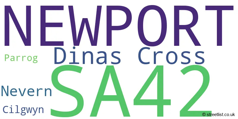
The largest settlement in the SA42 postal code is NEWPORT followed by DINAS CROSS, and NEVERN.
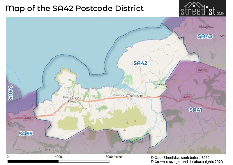
The postcode area has a boundary with Cardigan Bay.
The SA42 Postcode shares a border with SA43 (CARDIGAN, ABERPORTH, ST DOGMAELS) and SA65 (FISHGUARD, DWRBACH, PONTFAEN).
The primary settlement in the SA42 postcode district is Newport, located in the county of Dyfed in Wales. Other significant settlements in this district include Cilgwyn, Dinas Cross, Nevern, and Parrog. The most significant post town in this district is also Newport.
For the district SA42, we have data on 1 postcode sectors. Here's a breakdown: The sector SA42 0, covers Newport and Dinas Cross in Dyfed.
SA42 Postcode Sectors

Map of the SA42 Postcode District
Explore the SA42 postcode district by using our free interactive map.
When it comes to local government, postal geography often disregards political borders. However, for a breakdown in the SA42 District: the district mostly encompasses the Sir Benfro - Pembrokeshire area with a total of 155 postcodes.
Recent House Sales in SA42
| Date | Price | Address |
|---|---|---|
| 01/09/2023 | £800,000 | Fishguard Road, Newport, SA42 0UF |
| 25/08/2023 | £350,000 | Feidr Eglwys, Newport, SA42 0QA |
| 08/08/2023 | £390,000 | Fishguard Road, Newport, SA42 0UF |
| 24/07/2023 | £375,000 | Dinas Cross, Newport, SA42 0UP |
| 21/07/2023 | £450,000 | Newport, SA42 0NW |
| 21/07/2023 | £400,000 | Spring Hill, Dinas Cross, Newport, SA42 0XA |
| 19/07/2023 | £345,000 | Fishguard Road, Newport, SA42 0UG |
| 28/04/2023 | £345,000 | Dinas Cross, Newport, SA42 0SE |
| 28/04/2023 | £200,000 | Newport, SA42 0QU |
| 26/04/2023 | £325,000 | Dinas Cross, Newport, SA42 0UR |
Where is the SA42 Postcode District?
The postcode district for SA42 is located in Newport. Newport is surrounded by several nearby towns, such as Fishguard to the West (5.79 miles away), Crymych to the South East (8.74 miles away), Cardigan to the North East (8.85 miles away), Boncath to the East (10.53 miles away), and Clarbeston Road to the South (11.08 miles away). Additionally, the distance from Newport to the center of London is approximately 205.27 miles.
The district is within the post town of NEWPORT.
The sector has postcodes within the nation of Wales.
The SA42 Postcode District is in the South West Wales region of West Wales within the Wales.
Weather Forecast for SA42
Press Button to Show Forecast for Cwm Yr Eglwys (Beach)
| Time Period | Icon | Description | Temperature | Rain Probability | Wind |
|---|---|---|---|---|---|
| 09:00 to 12:00 | Overcast | 11.0°C (feels like 10.0°C) | 10.00% | N 7 mph | |
| 12:00 to 15:00 | Cloudy | 12.0°C (feels like 12.0°C) | 7.00% | N 4 mph | |
| 15:00 to 18:00 | Cloudy | 13.0°C (feels like 12.0°C) | 4.00% | NNW 7 mph | |
| 18:00 to 21:00 | Cloudy | 12.0°C (feels like 11.0°C) | 4.00% | N 4 mph | |
| 21:00 to 00:00 | Mist | 9.0°C (feels like 9.0°C) | 17.00% | WNW 2 mph |
Press Button to Show Forecast for Cwm Yr Eglwys (Beach)
| Time Period | Icon | Description | Temperature | Rain Probability | Wind |
|---|---|---|---|---|---|
| 00:00 to 03:00 | Fog | 8.0°C (feels like 8.0°C) | 16.00% | SW 2 mph | |
| 03:00 to 06:00 | Fog | 9.0°C (feels like 8.0°C) | 16.00% | SW 2 mph | |
| 06:00 to 09:00 | Cloudy | 10.0°C (feels like 10.0°C) | 13.00% | SSE 2 mph | |
| 09:00 to 12:00 | Cloudy | 14.0°C (feels like 13.0°C) | 4.00% | SW 4 mph | |
| 12:00 to 15:00 | Cloudy | 15.0°C (feels like 15.0°C) | 5.00% | WSW 7 mph | |
| 15:00 to 18:00 | Cloudy | 15.0°C (feels like 14.0°C) | 4.00% | WSW 7 mph | |
| 18:00 to 21:00 | Cloudy | 14.0°C (feels like 13.0°C) | 4.00% | W 4 mph | |
| 21:00 to 00:00 | Cloudy | 11.0°C (feels like 11.0°C) | 5.00% | S 2 mph |
Press Button to Show Forecast for Cwm Yr Eglwys (Beach)
| Time Period | Icon | Description | Temperature | Rain Probability | Wind |
|---|---|---|---|---|---|
| 00:00 to 03:00 | Mist | 10.0°C (feels like 9.0°C) | 13.00% | SSE 2 mph | |
| 03:00 to 06:00 | Fog | 9.0°C (feels like 9.0°C) | 16.00% | SE 4 mph | |
| 06:00 to 09:00 | Fog | 10.0°C (feels like 10.0°C) | 14.00% | SE 4 mph | |
| 09:00 to 12:00 | Cloudy | 15.0°C (feels like 14.0°C) | 5.00% | SSE 4 mph | |
| 12:00 to 15:00 | Cloudy | 17.0°C (feels like 16.0°C) | 4.00% | SW 4 mph | |
| 15:00 to 18:00 | Cloudy | 17.0°C (feels like 17.0°C) | 4.00% | SW 4 mph | |
| 18:00 to 21:00 | Cloudy | 16.0°C (feels like 16.0°C) | 4.00% | WNW 4 mph | |
| 21:00 to 00:00 | Cloudy | 13.0°C (feels like 13.0°C) | 4.00% | ENE 4 mph |
Press Button to Show Forecast for Cwm Yr Eglwys (Beach)
| Time Period | Icon | Description | Temperature | Rain Probability | Wind |
|---|---|---|---|---|---|
| 00:00 to 03:00 | Cloudy | 12.0°C (feels like 12.0°C) | 4.00% | E 4 mph | |
| 03:00 to 06:00 | Cloudy | 11.0°C (feels like 11.0°C) | 4.00% | E 4 mph | |
| 06:00 to 09:00 | Cloudy | 13.0°C (feels like 12.0°C) | 4.00% | ESE 4 mph | |
| 09:00 to 12:00 | Cloudy | 16.0°C (feels like 15.0°C) | 4.00% | SE 7 mph | |
| 12:00 to 15:00 | Cloudy | 18.0°C (feels like 16.0°C) | 4.00% | SSE 9 mph | |
| 15:00 to 18:00 | Cloudy | 18.0°C (feels like 17.0°C) | 4.00% | SSE 7 mph | |
| 18:00 to 21:00 | Sunny day | 17.0°C (feels like 17.0°C) | 1.00% | SSE 4 mph | |
| 21:00 to 00:00 | Clear night | 13.0°C (feels like 12.0°C) | 1.00% | S 4 mph |
Press Button to Show Forecast for Cwm Yr Eglwys (Beach)
| Time Period | Icon | Description | Temperature | Rain Probability | Wind |
|---|---|---|---|---|---|
| 00:00 to 03:00 | Clear night | 12.0°C (feels like 11.0°C) | 1.00% | SE 4 mph | |
| 03:00 to 06:00 | Clear night | 11.0°C (feels like 10.0°C) | 1.00% | ESE 4 mph | |
| 06:00 to 09:00 | Sunny day | 12.0°C (feels like 11.0°C) | 1.00% | ESE 4 mph | |
| 09:00 to 12:00 | Sunny day | 16.0°C (feels like 16.0°C) | 1.00% | SSE 7 mph | |
| 12:00 to 15:00 | Sunny day | 18.0°C (feels like 17.0°C) | 2.00% | S 9 mph | |
| 15:00 to 18:00 | Sunny day | 18.0°C (feels like 17.0°C) | 1.00% | S 9 mph | |
| 18:00 to 21:00 | Sunny day | 17.0°C (feels like 16.0°C) | 2.00% | S 7 mph | |
| 21:00 to 00:00 | Clear night | 13.0°C (feels like 12.0°C) | 3.00% | SSE 7 mph |
Postcode Sectors within the SA42 District
| Postcode Sector | Delivery Office |
|---|---|
| SA42 0 | Fishguard Delivery Office |
| S | A | 4 | 2 | - | X | X | X |
| S | A | 4 | 2 | Space | Numeric | Letter | Letter |
Current Monthly Rental Prices
| # Bedrooms | Min Price | Max Price | Avg Price |
|---|
Current House Prices
| # Bedrooms | Min Price | Max Price | Avg Price |
|---|---|---|---|
| £750,000 | £750,000 | £750,000 | |
| 1 | £164,950 | £164,950 | £164,950 |
| 2 | £180,000 | £459,000 | £313,429 |
| 3 | £250,000 | £795,000 | £491,216 |
| 4 | £335,000 | £750,000 | £500,714 |
| 5 | £500,000 | £600,000 | £550,000 |
Estate Agents who Operate in the SA42 District
| Logo | Name | Brand Name | Address | Contact Number | Total Properties |
|---|---|---|---|---|---|
 | Fishguard | JJ Morris | 21 West Street, Fishguard, SA65 9AL | 01341 408134 | 24 |
 | Cardigan | West Wales Properties | 41 High Street, Cardigan, Ceredigion, SA43 1JG | 01239 803032 | 6 |
 | Fishguard | John Francis | 15 West Street, Fishguard, SA65 9AE. | 01343 614734 | 3 |
 | Narberth | Fine & Country Pembrokeshire | 14 High Street High Street, Narberth, SA67 7AR | 01834 862138 | 1 |
Yearly House Price Averages for the SA42 Postcode District
| Type of Property | 2018 Average | 2018 Sales | 2017 Average | 2017 Sales | 2016 Average | 2016 Sales | 2015 Average | 2015 Sales |
|---|---|---|---|---|---|---|---|---|
| Detached | £366,709 | 26 | £380,063 | 23 | £294,663 | 16 | £311,240 | 25 |
| Semi-Detached | £227,954 | 9 | £338,667 | 6 | £205,125 | 8 | £273,571 | 7 |
| Terraced | £252,556 | 9 | £201,664 | 11 | £232,864 | 11 | £227,000 | 10 |
| Flats | £162,988 | 4 | £126,000 | 3 | £124,000 | 2 | £0 | 0 |