The SA7 postcode district is a postal district located in the SA Swansea postcode area with a population of 15,433 residents according to the 2021 England and Wales Census.
The area of the SA7 postcode district is 7.36 square miles which is 19.06 square kilometres or 4,709.85 acres.
Currently, the SA7 district has about 344 postcode units spread across 11 geographic postcode sectors.
Given that each sector allows for 400 unique postcode combinations, the district has a capacity of 4,400 postcodes. With 344 postcodes already in use, this leaves 4056 units available.
The largest settlement in the SA7 postal code is BIRCHGROVE followed by Llansamlet, and SWANSEA ENTERPRISE PARK.
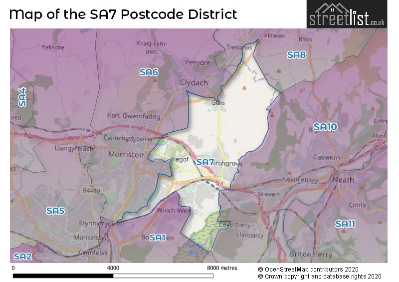
The SA7 Postcode shares a border with SA8 (PONTARDAWE, ALLTWEN, RHOS), SA6 (MORRISTON, CLYDACH, CWMRHYDYCEIRW), SA10 (SKEWEN, NEATH, SEVEN SISTERS) and SA1 (CITY CENTRE, MOUNT PLEASANT, TOWNHILL).
The primary settlement in the SA7 postcode district is Llansamlet, located in the county of West Glamorgan, Wales. Other significant settlements in this district include Birchgrove, Glais, Peniel Green, and Swansea Enterprise Park. These settlements are also located in West Glamorgan. The most significant post town in this district is Swansea.
For the district SA7, we have data on 2 postcode sectors. Here's a breakdown: The sector SA7 0, covers Swansea Vale and Birchgrove in West Glamorgan. The sector SA7 9, covers Llansamlet and Birchgrove and Swansea Enterprise Park and Glais in West Glamorgan.

Map of the SA7 Postcode District
Explore the SA7 postcode district by using our free interactive map.
When it comes to local government, postal geography often disregards political borders. However, for a breakdown in the SA7 District: the district mostly encompasses the Abertawe - Swansea area with a total of 345 postcodes.
Recent House Sales in SA73
| Date | Price | Address |
|---|---|---|
| 13/10/2023 | £260,000 | Honeyborough Road, Neyland, Milford Haven, SA73 1RF |
| 03/10/2023 | £353,000 | Liddeston Close, Liddeston, Milford Haven, SA73 3PY |
| 02/10/2023 | £169,999 | Sunningdale Drive, Hubberston, Milford Haven, SA73 3SA |
| 29/09/2023 | £200,000 | Pill Road, Milford Haven, SA73 2NL |
| 22/09/2023 | £222,000 | James Street, Neyland, Milford Haven, SA73 1RP |
| 11/09/2023 | £190,000 | Cambrian Road, Neyland, Milford Haven, SA73 1ST |
| 07/09/2023 | £54,000 | Robert Street, Milford Haven, SA73 2DJ |
| 07/09/2023 | £90,000 | Observatory Avenue, Hakin, Milford Haven, SA73 3EU |
| 04/09/2023 | £76,000 | Church Road, Hubberston, Milford Haven, SA73 3RE |
| 01/09/2023 | £62,500 | High Street, Neyland, Milford Haven, SA73 1SS |
Weather Forecast for SA7
Press Button to Show Forecast for Clydach
| Time Period | Icon | Description | Temperature | Rain Probability | Wind |
|---|---|---|---|---|---|
| 03:00 to 06:00 | Cloudy | 6.0°C (feels like 5.0°C) | 4.00% | NE 4 mph | |
| 06:00 to 09:00 | Cloudy | 6.0°C (feels like 4.0°C) | 6.00% | ENE 7 mph | |
| 09:00 to 12:00 | Cloudy | 9.0°C (feels like 6.0°C) | 8.00% | E 9 mph | |
| 12:00 to 15:00 | Overcast | 10.0°C (feels like 8.0°C) | 12.00% | ESE 9 mph | |
| 15:00 to 18:00 | Cloudy | 11.0°C (feels like 9.0°C) | 12.00% | ESE 9 mph | |
| 18:00 to 21:00 | Cloudy | 10.0°C (feels like 9.0°C) | 13.00% | E 7 mph | |
| 21:00 to 00:00 | Cloudy | 9.0°C (feels like 7.0°C) | 11.00% | ENE 9 mph |
Press Button to Show Forecast for Clydach
| Time Period | Icon | Description | Temperature | Rain Probability | Wind |
|---|---|---|---|---|---|
| 00:00 to 03:00 | Cloudy | 8.0°C (feels like 5.0°C) | 13.00% | ENE 9 mph | |
| 03:00 to 06:00 | Cloudy | 7.0°C (feels like 4.0°C) | 10.00% | ENE 11 mph | |
| 06:00 to 09:00 | Cloudy | 7.0°C (feels like 4.0°C) | 8.00% | ENE 11 mph | |
| 09:00 to 12:00 | Cloudy | 9.0°C (feels like 6.0°C) | 7.00% | ENE 13 mph | |
| 12:00 to 15:00 | Overcast | 11.0°C (feels like 8.0°C) | 14.00% | ENE 11 mph | |
| 15:00 to 18:00 | Overcast | 11.0°C (feels like 9.0°C) | 18.00% | ENE 11 mph | |
| 18:00 to 21:00 | Cloudy | 11.0°C (feels like 9.0°C) | 12.00% | NE 11 mph | |
| 21:00 to 00:00 | Overcast | 10.0°C (feels like 7.0°C) | 20.00% | NNE 11 mph |
Press Button to Show Forecast for Clydach
| Time Period | Icon | Description | Temperature | Rain Probability | Wind |
|---|---|---|---|---|---|
| 00:00 to 03:00 | Cloudy | 9.0°C (feels like 6.0°C) | 14.00% | NNE 11 mph | |
| 03:00 to 06:00 | Light rain | 8.0°C (feels like 5.0°C) | 47.00% | NNE 11 mph | |
| 06:00 to 09:00 | Light rain | 8.0°C (feels like 5.0°C) | 51.00% | N 11 mph | |
| 09:00 to 12:00 | Light rain shower (day) | 9.0°C (feels like 6.0°C) | 40.00% | N 13 mph | |
| 12:00 to 15:00 | Cloudy | 11.0°C (feels like 8.0°C) | 19.00% | NNW 16 mph | |
| 15:00 to 18:00 | Cloudy | 12.0°C (feels like 9.0°C) | 15.00% | NW 13 mph | |
| 18:00 to 21:00 | Sunny day | 11.0°C (feels like 8.0°C) | 8.00% | NW 13 mph | |
| 21:00 to 00:00 | Clear night | 9.0°C (feels like 7.0°C) | 5.00% | NW 9 mph |
Where is the SA7 Postcode District?
The postcode district SA7 is located in Swansea and is nearby several towns. To the East is Neath, which is approximately 2.57 miles away. Port Talbot is situated in the South East, about 7.32 miles away. Ammanford is located in the North West, approximately 10.52 miles away. Llanelli is to the West, about 12.01 miles away. Lastly, Llandeilo is situated in the North, approximately 16.49 miles away. Additionally, SA7 is approximately 161.91 miles away from London.
The district is within the post town of SWANSEA.
The sector has postcodes within the nation of Wales.
The SA7 Postcode District is covers the following regions.
- Swansea - West Wales - Wales
- Bridgend and Neath Port Talbot - West Wales - Wales
Postcode Sectors within the SA7 District
| Postcode Sector | Delivery Office |
|---|---|
| SA7 0 | Swansea Delivery Office |
| SA7 9 | Swansea Delivery Office |
| S | A | 7 | - | X | X | X |
| S | A | 7 | Space | Numeric | Letter | Letter |
Current Monthly Rental Prices
| # Bedrooms | Min Price | Max Price | Avg Price |
|---|---|---|---|
| 2 | £800 | £850 | £825 |
Current House Prices
| # Bedrooms | Min Price | Max Price | Avg Price |
|---|---|---|---|
| £18,000 | £19,950 | £18,975 | |
| 1 | £105,000 | £145,000 | £125,000 |
| 2 | £122,000 | £210,000 | £155,624 |
| 3 | £125,000 | £315,000 | £226,000 |
| 4 | £130,000 | £350,000 | £286,363 |
| 5 | £300,000 | £300,000 | £300,000 |
| 6 | £725,000 | £750,000 | £737,500 |
Estate Agents who Operate in the SA7 District
| Logo | Name | Brand Name | Address | Contact Number | Total Properties |
|---|---|---|---|---|---|
 | Morriston | Clee Tompkinson & Francis | 111 Clase Road Morriston Swansea SA6 8DY | 01792 949602 | 13 |
 | Morriston | Peter Alan | 25 Woodfield Street, Morriston, SA6 8AB | 01792 949584 | 8 |
 | Swansea | Astleys | 21 Walter Road, Uplands, Swansea, SA1 5NQ | 01792 949633 | 6 |
 | South West | Yopa | Meridian House Wheatfield Way Hinckley LE10 1YG | 01202 145444 | 5 |
 | covering Swansea | Purplebricks | Suite 7 First Floor Cranmore Drive Shirley Solihull B90 4RZ | 020 3889 9181 | 4 |
| Type of Property | 2018 Average | 2018 Sales | 2017 Average | 2017 Sales | 2016 Average | 2016 Sales | 2015 Average | 2015 Sales |
|---|---|---|---|---|---|---|---|---|
| Detached | £193,398 | 64 | £182,446 | 104 | £182,864 | 147 | £175,497 | 109 |
| Semi-Detached | £127,808 | 81 | £120,074 | 112 | £126,994 | 96 | £116,584 | 91 |
| Terraced | £105,696 | 62 | £96,728 | 48 | £97,333 | 77 | £103,582 | 57 |
| Flats | £0 | 0 | £83,000 | 4 | £26,000 | 1 | £258,000 | 2 |