
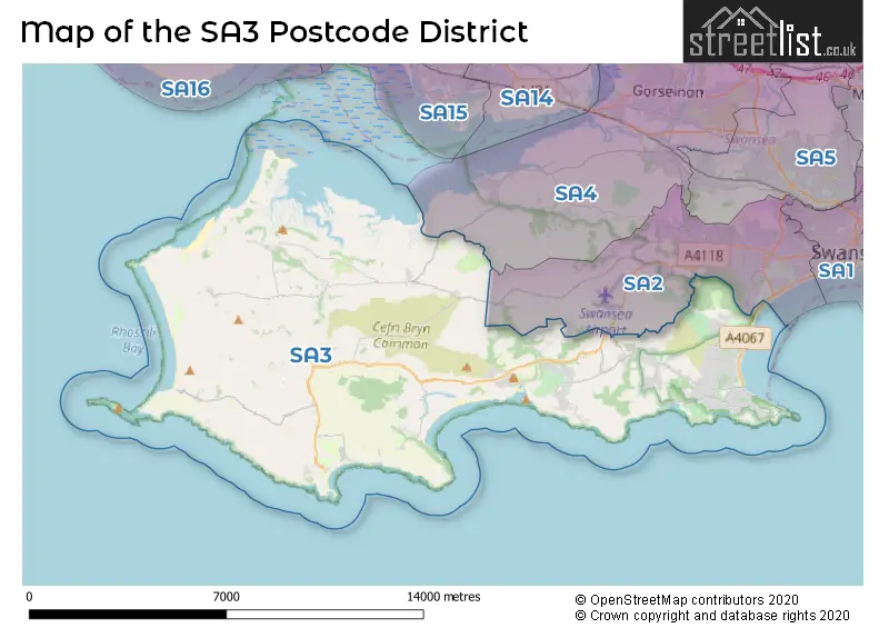
Map of the Postcode District
Explore the postcode district by using our interactive map.
Circles represent recorded crime; the larger the circle, the higher the crime rates.
Your support helps keep this site running!
If you enjoy using this website, consider buying me a coffee to help cover hosting costs.
The postcode district located in the SA Swansea postal area , SA3 has a population of 25,354 residents according to the 2021 England and Wales Census.
The area of the district is 50.67 square miles (131.25 square kilometers or 32,431.55 acres).
Where is the SA3 District?
To give you an idea where the district is located we have created the following table showing nearby towns.
Nearest Towns to SA3
| Town | Distance (miles) | Direction |
|---|---|---|
| Llanelli | 6.56 | N |
| Loughor | 7.07 | NE |
| Burry Port | 7.38 | NNW |
| Gorseinon | 8.06 | NE |
| Swansea | 10.30 | ENE |
| Pontarddulais | 10.50 | NNE |
| Kidwelly | 11.76 | NNW |
| Ammanford | 16.31 | NNE |
| Pontardawe | 16.70 | NE |
| Neath | 16.84 | ENE |
| Port Talbot | 16.86 | E |
| Laugharne | 17.68 | NW |
| Carmarthen | 19.43 | NNW |
| St Clears | 21.12 | NW |
| Porthcawl | 21.68 | ESE |
| Llandeilo | 21.84 | NNE |
| Maesteg | 22.20 | E |
| Ystradgynlais | 22.20 | NE |
| Tenby | 23.45 | WNW |
| Whitland | 24.72 | NW |
The post town for this district is SWANSEA.
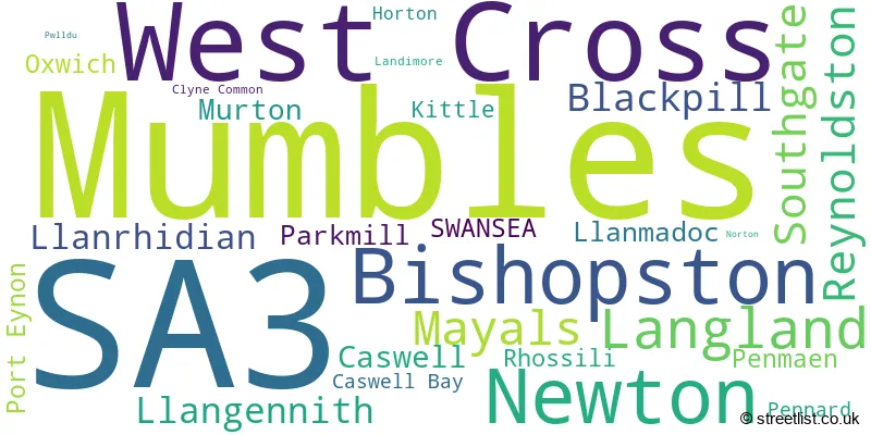
Postcode Information for District SA3 (Total Geographical Postcodes: 860)
| Location | Post Town | Sector | Number of Postcodes |
|---|---|---|---|
| West Cross | SWANSEA | SA3 5 | 154 |
| Mumbles | SWANSEA | SA3 4 | 142 |
| Bishopston | SWANSEA | SA3 3 | 74 |
| Newton | SWANSEA | SA3 4 | 70 |
| Langland | SWANSEA | SA3 4 | 68 |
| Mayals | SWANSEA | SA3 5 | 43 |
| Southgate | SWANSEA | SA3 2 | 38 |
| Reynoldston | SWANSEA | SA3 1 | 33 |
| Blackpill | SWANSEA | SA3 5 | 32 |
| Caswell | SWANSEA | SA3 4 | 23 |
| Mumbles | SWANSEA | SA3 5 | 23 |
| Murton | SWANSEA | SA3 3 | 21 |
| Llangennith | SWANSEA | SA3 1 | 21 |
| Llanrhidian | SWANSEA | SA3 1 | 18 |
| Llanmadoc | SWANSEA | SA3 1 | 12 |
| Parkmill | SWANSEA | SA3 2 | 12 |
| Port Eynon | SWANSEA | SA3 1 | 10 |
| Penmaen | SWANSEA | SA3 2 | 10 |
| Oxwich | SWANSEA | SA3 1 | 10 |
| Kittle | SWANSEA | SA3 3 | 9 |
| Rhossili | SWANSEA | SA3 1 | 9 |
| Pennard | SWANSEA | SA3 2 | 7 |
| Caswell Bay | SWANSEA | SA3 3 | 7 |
| Horton | SWANSEA | SA3 1 | 5 |
| Clyne Common | SWANSEA | SA3 3 | 3 |
| Landimore | SWANSEA | SA3 1 | 2 |
| Pwlldu | SWANSEA | SA3 2 | 1 |
| Norton | SWANSEA | SA3 5 | 1 |
| SWANSEA | SWANSEA | SA3 5 | 1 |
| Newton | SWANSEA | SA3 3 | 1 |
Retail and Shopping in SA3
Street
Town
Locality
Number of Shops
Central Postcode
View on Google Maps
NEWTON ROAD
SWANSEA
MUMBLES
73
SA3 4BE
View on Google Maps
MUMBLES ROAD
SWANSEA
MUMBLES
47
SA3 4DH
View on Google Maps
CHAPEL STREET
SWANSEA
MUMBLES
9
SA3 4NH
View on Google Maps
SOUTHGATE ROAD
SWANSEA
SOUTHGATE
7
SA3 2DH
View on Google Maps
WEST CROSS LANE
SWANSEA
WEST CROSS
7
SA3 5NG
View on Google Maps
SWANSEA
PORT EYNON
6
SA3 1NN
View on Google Maps
ALDERWOOD ROAD
SWANSEA
WEST CROSS
6
SA3 5JD
View on Google Maps
| Street | Town | Locality | Number of Shops | Central Postcode | View on Google Maps |
|---|---|---|---|---|---|
| NEWTON ROAD | SWANSEA | MUMBLES | 73 | SA3 4BE | View on Google Maps |
| MUMBLES ROAD | SWANSEA | MUMBLES | 47 | SA3 4DH | View on Google Maps |
| CHAPEL STREET | SWANSEA | MUMBLES | 9 | SA3 4NH | View on Google Maps |
| SOUTHGATE ROAD | SWANSEA | SOUTHGATE | 7 | SA3 2DH | View on Google Maps |
| WEST CROSS LANE | SWANSEA | WEST CROSS | 7 | SA3 5NG | View on Google Maps |
| SWANSEA | PORT EYNON | 6 | SA3 1NN | View on Google Maps | |
| ALDERWOOD ROAD | SWANSEA | WEST CROSS | 6 | SA3 5JD | View on Google Maps |
The primary settlement in the SA3 postcode district is Horton, located in the county of West Glamorgan, within the post town of Swansea. Other significant settlements in this postcode district include Landimore, Llangennith, Llanmadoc, Llanrhidian, Oxwich, Port Eynon, Reynoldston, and Rhossili. These settlements are also part of Swansea in the county of West Glamorgan.
When it comes to local government, postal geography often disregards political borders. However, this district intersects the following councils: the district mostly encompasses the Abertawe - Swansea area with a total of 735 postal codes.
The largest settlement in the SA3 postal code is WEST CROSS followed by MUMBLES, and Bishopston.
The postcode area has a boundary with The Bristol Channel.
The SA3 Postcode shares a border with SA4 (GORSEINON, PONTARDDULAIS, LOUGHOR) and SA2 (SKETTY, UPLANDS, KILLAY).


Stations in the Sector
No stations found in this postcode district.
Accessable Motorway Junctions
M4 J47
Average Driving Time from within the district: 17.63
Average Driving Distance: 9.71
Number of Postcodes that can access the Motorway Junction: 727
M4 J43
Average Driving Time from within the district: 17.82
Average Driving Distance: 10.40
Number of Postcodes that can access the Motorway Junction: 202
M4 J42
Average Driving Time from within the district: 18.43
Average Driving Distance: 10.21
Number of Postcodes that can access the Motorway Junction: 303
M4 J44
Average Driving Time from within the district: 18.94
Average Driving Distance: 9.79
Number of Postcodes that can access the Motorway Junction: 599
M4 J45
Average Driving Time from within the district: 19.02
Average Driving Distance: 10.91
Number of Postcodes that can access the Motorway Junction: 694
M4 J46
Average Driving Time from within the district: 19.41
Average Driving Distance: 10.57
Number of Postcodes that can access the Motorway Junction: 727
M4 J48
Average Driving Time from within the district: 25.48
Average Driving Distance: 16.60
Number of Postcodes that can access the Motorway Junction: 255
Weather Forecast for Oxwich Bay (Beach)
| Time Period | Icon | Description | Temperature | Rain Probability | Wind |
|---|---|---|---|---|---|
| 12:00 to 15:00 | Partly cloudy (day) | 15.0°C (feels like 13.0°C) | 2.00% | W 9 mph | |
| 15:00 to 18:00 | Sunny day | 15.0°C (feels like 13.0°C) | 1.00% | WSW 9 mph | |
| 18:00 to 21:00 | Partly cloudy (night) | 12.0°C (feels like 11.0°C) | 1.00% | W 4 mph | |
| 21:00 to 00:00 | Partly cloudy (night) | 13.0°C (feels like 11.0°C) | 3.00% | SSW 7 mph |
| Time Period | Icon | Description | Temperature | Rain Probability | Wind |
|---|---|---|---|---|---|
| 00:00 to 03:00 | Cloudy | 13.0°C (feels like 11.0°C) | 8.00% | SSW 9 mph | |
| 03:00 to 06:00 | Cloudy | 13.0°C (feels like 11.0°C) | 6.00% | SSW 9 mph | |
| 06:00 to 09:00 | Cloudy | 13.0°C (feels like 11.0°C) | 4.00% | SSW 9 mph | |
| 09:00 to 12:00 | Partly cloudy (day) | 14.0°C (feels like 12.0°C) | 2.00% | S 11 mph | |
| 12:00 to 15:00 | Partly cloudy (day) | 14.0°C (feels like 12.0°C) | 2.00% | S 11 mph | |
| 15:00 to 18:00 | Cloudy | 15.0°C (feels like 13.0°C) | 9.00% | S 11 mph | |
| 18:00 to 21:00 | Partly cloudy (night) | 14.0°C (feels like 11.0°C) | 1.00% | S 13 mph | |
| 21:00 to 00:00 | Partly cloudy (night) | 13.0°C (feels like 10.0°C) | 1.00% | SSE 16 mph |
| Time Period | Icon | Description | Temperature | Rain Probability | Wind |
|---|---|---|---|---|---|
| 00:00 to 03:00 | Cloudy | 13.0°C (feels like 10.0°C) | 3.00% | SSE 16 mph | |
| 03:00 to 06:00 | Cloudy | 13.0°C (feels like 10.0°C) | 4.00% | SSE 16 mph | |
| 06:00 to 09:00 | Partly cloudy (night) | 13.0°C (feels like 10.0°C) | 1.00% | SSE 18 mph | |
| 09:00 to 12:00 | Cloudy | 14.0°C (feels like 10.0°C) | 6.00% | SSE 18 mph | |
| 12:00 to 15:00 | Overcast | 15.0°C (feels like 12.0°C) | 15.00% | SSE 18 mph | |
| 15:00 to 18:00 | Light rain shower (day) | 16.0°C (feels like 12.0°C) | 37.00% | SSE 18 mph | |
| 18:00 to 21:00 | Heavy rain shower (night) | 15.0°C (feels like 12.0°C) | 64.00% | S 18 mph | |
| 21:00 to 00:00 | Heavy rain | 14.0°C (feels like 11.0°C) | 81.00% | SSW 18 mph |
| Time Period | Icon | Description | Temperature | Rain Probability | Wind |
|---|---|---|---|---|---|
| 00:00 to 03:00 | Heavy rain shower (night) | 13.0°C (feels like 10.0°C) | 57.00% | SW 18 mph | |
| 03:00 to 06:00 | Light rain shower (night) | 12.0°C (feels like 9.0°C) | 37.00% | SW 16 mph | |
| 06:00 to 09:00 | Light rain shower (night) | 11.0°C (feels like 9.0°C) | 33.00% | WSW 16 mph | |
| 09:00 to 12:00 | Light rain shower (day) | 12.0°C (feels like 9.0°C) | 33.00% | WSW 13 mph | |
| 12:00 to 15:00 | Light rain shower (day) | 12.0°C (feels like 9.0°C) | 37.00% | WNW 18 mph | |
| 15:00 to 18:00 | Partly cloudy (day) | 12.0°C (feels like 9.0°C) | 12.00% | WNW 16 mph | |
| 18:00 to 21:00 | Partly cloudy (night) | 11.0°C (feels like 8.0°C) | 5.00% | W 16 mph | |
| 21:00 to 00:00 | Partly cloudy (night) | 11.0°C (feels like 8.0°C) | 4.00% | W 16 mph |
| Time Period | Icon | Description | Temperature | Rain Probability | Wind |
|---|---|---|---|---|---|
| 00:00 to 03:00 | Partly cloudy (night) | 11.0°C (feels like 8.0°C) | 10.00% | W 16 mph | |
| 03:00 to 06:00 | Light rain shower (night) | 11.0°C (feels like 8.0°C) | 35.00% | WSW 16 mph | |
| 06:00 to 09:00 | Cloudy | 12.0°C (feels like 9.0°C) | 24.00% | WSW 16 mph | |
| 09:00 to 12:00 | Light rain | 13.0°C (feels like 10.0°C) | 52.00% | WSW 16 mph | |
| 12:00 to 15:00 | Light rain | 13.0°C (feels like 10.0°C) | 53.00% | WSW 18 mph | |
| 15:00 to 18:00 | Light rain shower (day) | 14.0°C (feels like 10.0°C) | 41.00% | WSW 18 mph | |
| 18:00 to 21:00 | Partly cloudy (night) | 13.0°C (feels like 10.0°C) | 14.00% | W 18 mph | |
| 21:00 to 00:00 | Partly cloudy (night) | 13.0°C (feels like 10.0°C) | 11.00% | W 16 mph |
| Postal Sector | Delivery Office |
|---|---|
| SA3 1 | Gorseinon Delivery Office |
| SA3 2 | Mumbles Delivery Office |
| SA3 3 | Mumbles Delivery Office |
| SA3 4 | Mumbles Delivery Office |
| SA3 5 | Mumbles Delivery Office |
| S | A | 3 | - | X | X | X |
| S | A | 3 | Space | Numeric | Letter | Letter |
Tourist Attractions
We found 3 visitor attractions.
| Oxwich Castle |
|---|
| View Oxwich Castle on Google Maps |
| Oystermouth Castle |
| View Oystermouth Castle on Google Maps |
| Weobley Castle |
| View Weobley Castle on Google Maps |
Street List for the SA3 District
Current Monthly Rental Prices
| # Bedrooms | Min Price | Max Price | Avg Price |
|---|---|---|---|
| 1 | £750 | £750 | £750 |
| 2 | £900 | £1,250 | £1,075 |
| 3 | £1,500 | £1,500 | £1,500 |
Current House Prices
| # Bedrooms | Min Price | Max Price | Avg Price |
|---|---|---|---|
| £210,000 | £399,000 | £284,750 | |
| 1 | £50,000 | £445,000 | £183,564 |
| 2 | £55,995 | £699,000 | £260,330 |
| 3 | £175,000 | £775,000 | £455,345 |
| 4 | £300,000 | £1,500,000 | £687,028 |
| 5 | £525,000 | £995,000 | £723,500 |
| 6 | £1,075,000 | £1,100,000 | £1,087,500 |
| 7 | £650,000 | £725,000 | £687,500 |
| 9 | £500,000 | £500,000 | £500,000 |
Estate Agents
| Logo | Name | Brand Name | Address | Contact Number |
|---|---|---|---|---|
 | Mumbles | Astleys | 33a Newton Road, Mumbles, SA3 4AS | 01748 902908 |
 | Mumbles | Simpsons | 68 Newton Road, Mumbles, SA3 4BE | 01792 949600 |
 | Mumbles | John Francis | 76 Newton Road, Mumbles, SA3 4BE | 01792 949736 |
 | Mumbles | The Greenroom | Gower House 29-30 Dunns Lane Mumbles SA3 4AA | 01792 949654 |
 | covering Swansea | Purplebricks | Suite 7 First Floor Cranmore Drive Shirley Solihull B90 4RZ | 020 3889 9181 |
Yearly House Price Averages for the District
| Type of Property | 2018 Average | 2018 Sales | 2017 Average | 2017 Sales | 2016 Average | 2016 Sales | 2015 Average | 2015 Sales |
|---|---|---|---|---|---|---|---|---|
| Detached | £429,492 | 196 | £396,223 | 171 | £381,349 | 194 | £382,290 | 196 |
| Semi-Detached | £264,309 | 119 | £248,978 | 149 | £232,810 | 130 | £228,119 | 111 |
| Terraced | £224,815 | 74 | £210,966 | 89 | £253,841 | 95 | £211,526 | 103 |
| Flats | £182,606 | 66 | £191,186 | 88 | £193,734 | 95 | £182,627 | 64 |