The CF41 postcode district is a postal district located in the CF Cardiff postcode area with a population of 10,666 residents according to the 2021 England and Wales Census.
The area of the CF41 postcode district is 4.93 square miles which is 12.77 square kilometres or 3,155.21 acres.
Currently, the CF41 district has about 248 postcode units spread across 1 geographic postcode sectors.
Given that each sector allows for 400 unique postcode combinations, the district has a capacity of 400 postcodes. With 248 postcodes already in use, this leaves 152 units available.
The largest settlement in the CF41 postal code is PENTRE followed by YSTRAD, and GELLI.
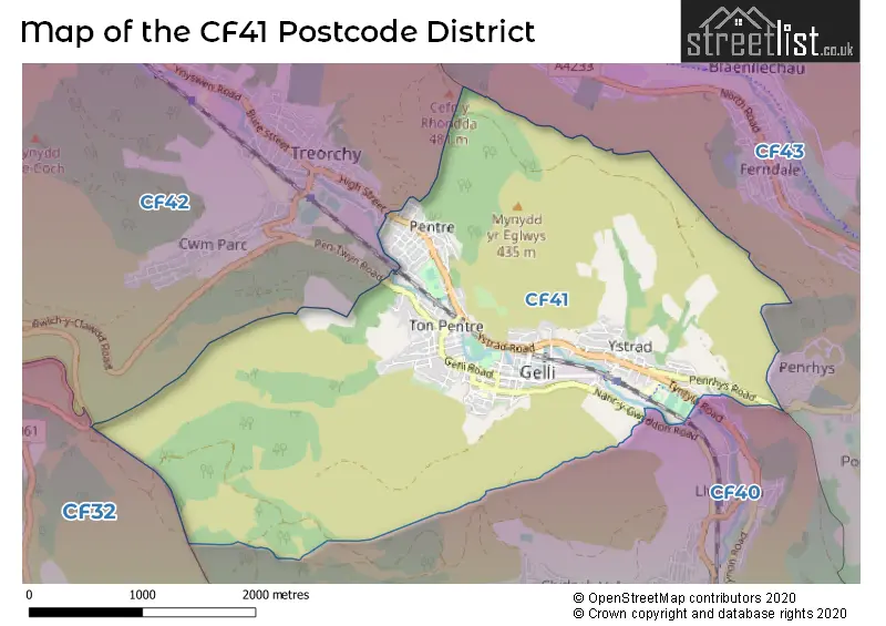
The CF41 Postcode shares a border with CF42 (TREORCHY, Treherbert, CWM-PARC), CF40 (TONYPANDY, TREALAW, PEN-Y-GRAIG) and CF43 (FERNDALE, MAERDY, Tylorstown).
The primary settlement in the CF41 postcode district is Pentre, located in Mid Glamorgan, Wales. Other significant settlements in the area include Gelli, Ton Pentre, and Ystrad.
For the district CF41, we have data on 1 postcode sectors. Here's a breakdown: The sector CF41 7, covers Pentre and Gelli and Ton Pentre and Ystrad in Mid Glamorgan.
CF41 Postcode Sectors

Map of the CF41 Postcode District
Explore the CF41 postcode district by using our free interactive map.
When it comes to local government, postal geography often disregards political borders. However, for a breakdown in the CF41 District: the district mostly encompasses the Rhondda Cynon Taf - Rhondda Cynon Taf area with a total of 248 postcodes.
Where is the CF41 Postcode District?
The data's postcode district, CF41, is located in the town of Pentre. Pentre is surrounded by several nearby towns and the distances to them are as follows: Ferndale (1.71 miles to the North East), Treorchy (1.82 miles to the North West), Tonypandy (2.45 miles to the South East), Aberdare (5.08 miles to the North), Treharris (7.56 miles to the East), and Maesteg (7.75 miles to the West). Additionally, Pentre is approximately 144.92 miles away from the center of London.
The district is within the post town of PENTRE.
The sector has postcodes within the nation of Wales.
The CF41 Postcode District is in the Central Valleys region of West Wales within the Wales.
Weather Forecast for CF41
Press Button to Show Forecast for Llwynypia Youth Hostel
| Time Period | Icon | Description | Temperature | Rain Probability | Wind |
|---|---|---|---|---|---|
| 12:00 to 15:00 | Cloudy | 19.0°C (feels like 17.0°C) | 3.00% | SE 9 mph | |
| 15:00 to 18:00 | Cloudy | 21.0°C (feels like 19.0°C) | 4.00% | SE 9 mph | |
| 18:00 to 21:00 | Cloudy | 20.0°C (feels like 19.0°C) | 4.00% | SSE 7 mph | |
| 21:00 to 00:00 | Cloudy | 15.0°C (feels like 15.0°C) | 3.00% | ESE 4 mph |
Press Button to Show Forecast for Llwynypia Youth Hostel
| Time Period | Icon | Description | Temperature | Rain Probability | Wind |
|---|---|---|---|---|---|
| 00:00 to 03:00 | Cloudy | 14.0°C (feels like 14.0°C) | 4.00% | E 4 mph | |
| 03:00 to 06:00 | Cloudy | 13.0°C (feels like 12.0°C) | 3.00% | E 4 mph | |
| 06:00 to 09:00 | Cloudy | 13.0°C (feels like 13.0°C) | 4.00% | E 4 mph | |
| 09:00 to 12:00 | Cloudy | 17.0°C (feels like 16.0°C) | 4.00% | ESE 7 mph | |
| 12:00 to 15:00 | Cloudy | 20.0°C (feels like 18.0°C) | 6.00% | SE 9 mph | |
| 15:00 to 18:00 | Thunder shower (day) | 19.0°C (feels like 18.0°C) | 57.00% | S 7 mph | |
| 18:00 to 21:00 | Light rain shower (day) | 15.0°C (feels like 14.0°C) | 27.00% | WSW 7 mph | |
| 21:00 to 00:00 | Mist | 12.0°C (feels like 11.0°C) | 16.00% | WSW 4 mph |
Press Button to Show Forecast for Llwynypia Youth Hostel
| Time Period | Icon | Description | Temperature | Rain Probability | Wind |
|---|---|---|---|---|---|
| 00:00 to 03:00 | Fog | 11.0°C (feels like 10.0°C) | 18.00% | WSW 4 mph | |
| 03:00 to 06:00 | Fog | 10.0°C (feels like 9.0°C) | 22.00% | SSW 4 mph | |
| 06:00 to 09:00 | Fog | 10.0°C (feels like 8.0°C) | 28.00% | SSE 9 mph | |
| 09:00 to 12:00 | Light rain | 11.0°C (feels like 9.0°C) | 61.00% | SSE 16 mph | |
| 12:00 to 15:00 | Heavy rain | 12.0°C (feels like 9.0°C) | 90.00% | SSE 18 mph | |
| 15:00 to 18:00 | Heavy rain | 12.0°C (feels like 9.0°C) | 93.00% | SSE 13 mph | |
| 18:00 to 21:00 | Heavy rain | 12.0°C (feels like 9.0°C) | 91.00% | SSE 11 mph | |
| 21:00 to 00:00 | Heavy rain | 11.0°C (feels like 9.0°C) | 82.00% | SSW 7 mph |
Press Button to Show Forecast for Llwynypia Youth Hostel
| Time Period | Icon | Description | Temperature | Rain Probability | Wind |
|---|---|---|---|---|---|
| 00:00 to 03:00 | Cloudy | 10.0°C (feels like 8.0°C) | 21.00% | SSE 9 mph | |
| 03:00 to 06:00 | Overcast | 9.0°C (feels like 7.0°C) | 20.00% | SE 9 mph | |
| 06:00 to 09:00 | Overcast | 9.0°C (feels like 7.0°C) | 24.00% | SSE 11 mph | |
| 09:00 to 12:00 | Light rain shower (day) | 11.0°C (feels like 8.0°C) | 42.00% | SSE 13 mph | |
| 12:00 to 15:00 | Light rain shower (day) | 12.0°C (feels like 9.0°C) | 41.00% | SSE 16 mph | |
| 15:00 to 18:00 | Light rain shower (day) | 12.0°C (feels like 10.0°C) | 42.00% | S 13 mph | |
| 18:00 to 21:00 | Light rain shower (day) | 11.0°C (feels like 9.0°C) | 45.00% | S 13 mph | |
| 21:00 to 00:00 | Light rain shower (night) | 10.0°C (feels like 7.0°C) | 35.00% | S 11 mph |
Press Button to Show Forecast for Llwynypia Youth Hostel
| Time Period | Icon | Description | Temperature | Rain Probability | Wind |
|---|---|---|---|---|---|
| 00:00 to 03:00 | Overcast | 9.0°C (feels like 7.0°C) | 18.00% | SSE 11 mph | |
| 03:00 to 06:00 | Overcast | 9.0°C (feels like 6.0°C) | 19.00% | SSE 11 mph | |
| 06:00 to 09:00 | Overcast | 9.0°C (feels like 6.0°C) | 19.00% | SSE 11 mph | |
| 09:00 to 12:00 | Light rain shower (day) | 11.0°C (feels like 8.0°C) | 40.00% | SSE 11 mph | |
| 12:00 to 15:00 | Light rain shower (day) | 12.0°C (feels like 10.0°C) | 40.00% | S 13 mph | |
| 15:00 to 18:00 | Heavy rain shower (day) | 12.0°C (feels like 10.0°C) | 58.00% | S 11 mph | |
| 18:00 to 21:00 | Light rain shower (day) | 11.0°C (feels like 9.0°C) | 37.00% | S 11 mph | |
| 21:00 to 00:00 | Partly cloudy (night) | 9.0°C (feels like 7.0°C) | 10.00% | S 9 mph |
Postcode Sectors within the CF41 District
| Postcode Sector | Delivery Office |
|---|---|
| CF41 7 | Treorchy Delivery Office |
| C | F | 4 | 1 | - | X | X | X |
| C | F | 4 | 1 | Space | Numeric | Letter | Letter |
Current Monthly Rental Prices
| # Bedrooms | Min Price | Max Price | Avg Price |
|---|---|---|---|
| 3 | £775 | £800 | £788 |
Current House Prices
| # Bedrooms | Min Price | Max Price | Avg Price |
|---|---|---|---|
| 2 | £129,950 | £185,000 | £157,475 |
| 3 | £129,995 | £425,000 | £198,603 |
| 4 | £149,950 | £495,000 | £328,536 |
| 5 | £225,000 | £395,000 | £320,000 |
Estate Agents who Operate in the CF41 District
| Logo | Name | Brand Name | Address | Contact Number | Total Properties |
|---|---|---|---|---|---|
 | Tonyrefail | Property Plus Estate Agents | 22 Mill Street Tonyrefail CF39 8AA | 01440 840589 | 31 |
 | covering Tonypandy | Darlows | covering Tonypandy | 01443 801714 | 6 |
 | Tonypandy | Osborne Estates | Unit 3, 97 Dunraven Street Tonypandy CF40 1AR | 01443 809433 | 4 |
 | Pencoed | Hunters | 18 Coychurch Road, Pencoed, CF35 5NG | 01656 331557 | 2 |
 | Talbot Green | Allen & Harris | 83 Talbot Road, Pontyclun, Mid Glarmorgan, S Wales, CF72 8AE | 01443 706462 | 2 |
Yearly House Price Averages for the CF41 Postcode District
| Type of Property | 2018 Average | 2018 Sales | 2017 Average | 2017 Sales | 2016 Average | 2016 Sales | 2015 Average | 2015 Sales |
|---|---|---|---|---|---|---|---|---|
| Detached | £219,271 | 7 | £199,813 | 8 | £177,222 | 9 | £123,750 | 9 |
| Semi-Detached | £124,883 | 9 | £89,542 | 12 | £101,429 | 14 | £118,600 | 10 |
| Terraced | £75,589 | 137 | £68,043 | 148 | £68,839 | 134 | £64,615 | 120 |
| Flats | £28,000 | 1 | £28,583 | 6 | £26,500 | 3 | £0 | 0 |