The CF46 postcode district is a postal district located in the CF Cardiff postcode area with a population of 14,524 residents according to the 2021 England and Wales Census.
The area of the CF46 postcode district is 13.29 square miles which is 34.43 square kilometres or 8,508.74 acres.
Currently, the CF46 district has about 347 postcode units spread across 2 geographic postcode sectors.
Given that each sector allows for 400 unique postcode combinations, the district has a capacity of 800 postcodes. With 347 postcodes already in use, this leaves 453 units available.
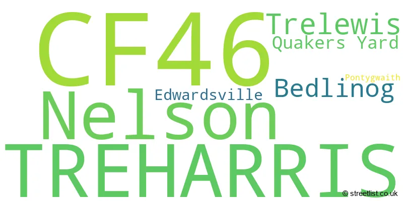
The largest settlement in the CF46 postal code is TREHARRIS followed by NELSON, and TRELEWIS.
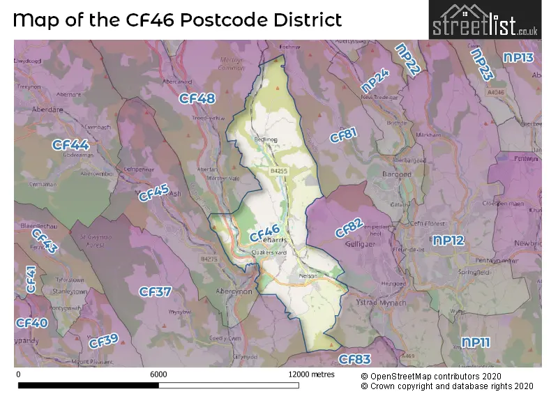
The CF46 Postcode shares a border with CF83 (CAERPHILLY, BEDWAS, LLANBRADACH), CF45 (MOUNTAIN ASH, ABERCYNON, Penrhiwceiber), CF81 (BARGOED, ABERBARGOED, GILFACH), CF82 (YSTRAD MYNACH, PENPEDAIRHEOL, CEFN HENGOED), CF37 (PONTYPRIDD, TREFOREST, RHYDYFELIN) and CF48 (DOWLAIS, MERTHYR TYDFIL, TROEDYRHIW).
The primary settlement in the CF46 postcode district is Trelewis, located in the county of Mid Glamorgan. Other significant settlements in the district include Treharris, Edwardsville, Pontygwaith, and Quakers Yard. The district also includes the settlements of Bedlinog and Nelson, which are located in the counties of Mid Glamorgan and Gwent respectively. The most significant post town in the CF46 district is Treharris. Mid Glamorgan is located in Wales.
For the district CF46, we have data on 2 postcode sectors. Here's a breakdown: The sector CF46 5, covers Treharris and Quakers Yard in Mid Glamorgan. The sector CF46 6, covers Nelson in Gwent. The sector CF46 6, covers Trelewis and Bedlinog in Mid Glamorgan.

Map of the CF46 Postcode District
Explore the CF46 postcode district by using our free interactive map.
When it comes to local government, postal geography often disregards political borders. However, for a breakdown in the CF46 District: the district mostly encompasses the Merthyr Tudful - Merthyr Tydfil (252 postcodes), and finally, the Caerffili - Caerphilly area (96 postcodes).
Weather Forecast for CF46
Press Button to Show Forecast for Mountain Ash
| Time Period | Icon | Description | Temperature | Rain Probability | Wind |
|---|---|---|---|---|---|
| 00:00 to 03:00 | Cloudy | 7.0°C (feels like 6.0°C) | 5.00% | NNE 4 mph | |
| 03:00 to 06:00 | Cloudy | 6.0°C (feels like 4.0°C) | 5.00% | NE 4 mph | |
| 06:00 to 09:00 | Cloudy | 6.0°C (feels like 4.0°C) | 9.00% | ENE 7 mph | |
| 09:00 to 12:00 | Cloudy | 7.0°C (feels like 5.0°C) | 11.00% | E 9 mph | |
| 12:00 to 15:00 | Overcast | 10.0°C (feels like 8.0°C) | 14.00% | E 9 mph | |
| 15:00 to 18:00 | Overcast | 10.0°C (feels like 8.0°C) | 16.00% | E 9 mph | |
| 18:00 to 21:00 | Cloudy | 9.0°C (feels like 7.0°C) | 17.00% | ENE 7 mph | |
| 21:00 to 00:00 | Cloudy | 7.0°C (feels like 5.0°C) | 16.00% | ENE 7 mph |
Press Button to Show Forecast for Mountain Ash
| Time Period | Icon | Description | Temperature | Rain Probability | Wind |
|---|---|---|---|---|---|
| 00:00 to 03:00 | Cloudy | 6.0°C (feels like 4.0°C) | 16.00% | ENE 7 mph | |
| 03:00 to 06:00 | Cloudy | 5.0°C (feels like 3.0°C) | 15.00% | NE 7 mph | |
| 06:00 to 09:00 | Cloudy | 5.0°C (feels like 3.0°C) | 14.00% | NE 9 mph | |
| 09:00 to 12:00 | Light rain | 7.0°C (feels like 4.0°C) | 49.00% | NE 11 mph | |
| 12:00 to 15:00 | Overcast | 9.0°C (feels like 6.0°C) | 23.00% | ENE 11 mph | |
| 15:00 to 18:00 | Cloudy | 10.0°C (feels like 8.0°C) | 19.00% | NE 11 mph | |
| 18:00 to 21:00 | Cloudy | 10.0°C (feels like 7.0°C) | 19.00% | NE 9 mph | |
| 21:00 to 00:00 | Light rain | 8.0°C (feels like 5.0°C) | 52.00% | NE 9 mph |
Press Button to Show Forecast for Mountain Ash
| Time Period | Icon | Description | Temperature | Rain Probability | Wind |
|---|---|---|---|---|---|
| 00:00 to 03:00 | Cloudy | 7.0°C (feels like 4.0°C) | 21.00% | NNE 9 mph | |
| 03:00 to 06:00 | Heavy rain | 7.0°C (feels like 4.0°C) | 70.00% | NNE 9 mph | |
| 06:00 to 09:00 | Light rain | 7.0°C (feels like 4.0°C) | 53.00% | NNE 9 mph | |
| 09:00 to 12:00 | Heavy rain | 9.0°C (feels like 6.0°C) | 69.00% | NNE 9 mph | |
| 12:00 to 15:00 | Light rain shower (day) | 11.0°C (feels like 9.0°C) | 38.00% | NW 9 mph | |
| 15:00 to 18:00 | Light rain | 11.0°C (feels like 10.0°C) | 49.00% | NW 9 mph | |
| 18:00 to 21:00 | Partly cloudy (day) | 11.0°C (feels like 9.0°C) | 12.00% | WNW 9 mph | |
| 21:00 to 00:00 | Clear night | 8.0°C (feels like 6.0°C) | 5.00% | W 7 mph |
Where is the CF46 Postcode District?
The CF46 postcode district is located in Treharris, a town in South Wales. It is surrounded by several nearby towns, including Bargoed to the East (2.64 miles away), Mountain Ash to the West (3.01 miles away), Hengoed to the South East (3.14 miles away), New Tredegar to the North East (4.40 miles away), Pontypridd to the South (5.29 miles away), Porth to the South West (6.36 miles away), and Merthyr Tydfil to the North West (6.42 miles away). Additionally, Treharris is situated 137.06 miles away from the center of London.
The district is within the post town of TREHARRIS.
The sector has postcodes within the nation of Wales.
The CF46 Postcode District is covers the following regions.
- Central Valleys - West Wales - Wales
- Gwent Valleys - West Wales - Wales
| Postcode Sector | Delivery Office |
|---|---|
| CF46 5 | Treharris Delivery Office |
| CF46 6 | Treharris Delivery Office |
| C | F | 4 | 6 | - | X | X | X |
| C | F | 4 | 6 | Space | Numeric | Letter | Letter |
Tourist Attractions within the Postcode Area
We found 1 visitor attractions within the CF46 postcode area
| Llancaiach Fawr Manor |
|---|
| View Llancaiach Fawr Manor on Google Maps |
Current Monthly Rental Prices
| # Bedrooms | Min Price | Max Price | Avg Price |
|---|---|---|---|
| £400 | £450 | £425 | |
| 1 | £495 | £495 | £495 |
| 3 | £695 | £700 | £698 |
Current House Prices
| # Bedrooms | Min Price | Max Price | Avg Price |
|---|---|---|---|
| 3 | £350,000 | £395,000 | £366,250 |
| 4 | £360,000 | £800,000 | £441,000 |
| 5 | £425,000 | £500,000 | £481,113 |
| 7 | £343,000 | £925,000 | £634,000 |
Estate Agents who Operate in the CF46 District
| Logo | Name | Brand Name | Address | Contact Number | Total Properties |
|---|---|---|---|---|---|
 | Treharris | Bayside Estates | Bayside Property Lounge, Unit C, 20-22 Commercial Street, Nelson, CF46 6NF | 01443 706446 | 32 |
 | Caerphilly | Brinsons | Eastgate, Market Street, Caerphilly, CF83 1NX | 029 2271 1584 | 11 |
 | Merthyr Tydfil | Peter Alan | 133 High Street, Merthyr Tydfil, CF47 8DN | 01685 701136 | 9 |
 | Merthyr Tydfil | Darlows | 32 Victoria Street, Merthyr Tydfil, CF47 8BW | 01685 708673 | 9 |
 | Ystrad Mynach | Lucas Estates & Rentals | 22 Penallta Road, Ystrad Mynach, CF82 7AP | 01443 706470 | 7 |
| Type of Property | 2018 Average | 2018 Sales | 2017 Average | 2017 Sales | 2016 Average | 2016 Sales | 2015 Average | 2015 Sales |
|---|---|---|---|---|---|---|---|---|
| Detached | £208,193 | 38 | £224,078 | 69 | £221,704 | 83 | £196,364 | 69 |
| Semi-Detached | £134,819 | 54 | £126,300 | 59 | £120,561 | 84 | £123,706 | 84 |
| Terraced | £88,634 | 96 | £81,087 | 107 | £72,988 | 91 | £74,260 | 90 |
| Flats | £86,000 | 1 | £0 | 0 | £47,750 | 2 | £0 | 0 |