The CF83 postcode district is a postal district located in the CF Cardiff postcode area with a population of 54,568 residents according to the 2021 England and Wales Census.
The area of the CF83 postcode district is 27.20 square miles which is 70.44 square kilometres or 17,406.69 acres.
Currently, the CF83 district has about 1206 postcode units spread across 5 geographic postcode sectors.
Given that each sector allows for 400 unique postcode combinations, the district has a capacity of 2,000 postcodes. With 1206 postcodes already in use, this leaves 794 units available.
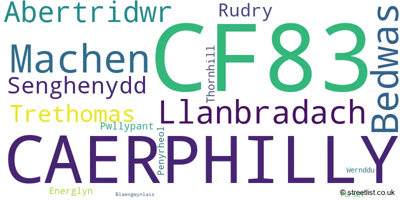
The largest settlement in the CF83 postal code is CAERPHILLY followed by BEDWAS, and LLANBRADACH.
The CF83 Postcode shares a border with NP11 (PONTYMISTER, NEWBRIDGE, ABERCARN), NP10 (ROGERSTONE, NEWPORT, BASSALEG), CF46 (TREHARRIS, NELSON, TRELEWIS), CF82 (YSTRAD MYNACH, PENPEDAIRHEOL, CEFN HENGOED), CF14 (WHITCHURCH, CARDIFF, GABALFA), CF15 (RADYR, PENTYRCH, TONGWYNLAIS) and CF37 (PONTYPRIDD, TREFOREST, RHYDYFELIN).
In the CF83 postcode district, the primary settlement is Caerphilly, located in Gwent county, Wales. The most significant post town in this district is Caerphilly. The other significant settlements in this district include Thornhill, Blaengwynlais, Energlyn, Penyrheol, Pwllypant, Llanbradach, Porset, Rudry, Wernddu, Abertridwr, Senghenydd, Bedwas, Machen, and Trethomas, all located in Gwent county, Wales.
For the district CF83, we have data on 6 postcode sectors. Here's a breakdown: The sector CF83 1, covers Caerphilly in Gwent. The sector CF83 2, covers Caerphilly in Gwent. The sector CF83 3, covers Caerphilly and Llanbradach in Gwent. The sector CF83 4, covers Abertridwr and Senghenydd in Gwent. The sector CF83 8, covers Machen and Bedwas and Trethomas in Gwent. The sector CF83 9 is non-geographic. It's often designated for PO Boxes, large organisations, or special services.

Map of the CF83 Postcode District
Explore the CF83 postcode district by using our free interactive map.
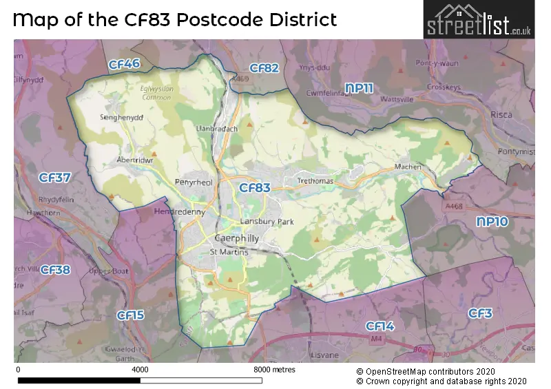
When it comes to local government, postal geography often disregards political borders. However, for a breakdown in the CF83 District: the district mostly encompasses the Caerffili - Caerphilly (1201 postcodes), and finally, the Caerdydd - Cardiff area (3 postcodes).
Where is the CF83 Postcode District?
The CF83 postcode district is located in Caerphilly. It is surrounded by several nearby towns. To the North, there is Hengoed, which is approximately 4.8 miles away. To the West, there is Pontypridd, which is about 5.7 miles away. Cardiff is situated to the South and is approximately 6.2 miles from CF83. Treharris is located to the North West, around 6.8 miles away. Cwmbran is positioned to the North East, with a distance of approximately 8.8 miles from CF83. Finally, Pontyclun is situated to the South West, about 8.8 miles away. Additionally, CF83 is about 132.9 miles away from the center of London.
The district is within the post town of CAERPHILLY.
The sector has postcodes within the nation of Wales.
The CF83 Postcode District is covers the following regions.
- Gwent Valleys - West Wales - Wales
- Cardiff and Vale of Glamorgan - East Wales - Wales
Weather Forecast for CF83
Press Button to Show Forecast for Bedwas
| Time Period | Icon | Description | Temperature | Rain Probability | Wind |
|---|---|---|---|---|---|
| 15:00 to 18:00 | Heavy rain shower (day) | 16.0°C (feels like 13.0°C) | 61.00% | SSE 13 mph | |
| 18:00 to 21:00 | Light rain shower (day) | 15.0°C (feels like 13.0°C) | 40.00% | SE 9 mph | |
| 21:00 to 00:00 | Cloudy | 14.0°C (feels like 12.0°C) | 4.00% | ESE 9 mph |
Press Button to Show Forecast for Bedwas
| Time Period | Icon | Description | Temperature | Rain Probability | Wind |
|---|---|---|---|---|---|
| 00:00 to 03:00 | Cloudy | 13.0°C (feels like 11.0°C) | 4.00% | ESE 7 mph | |
| 03:00 to 06:00 | Cloudy | 12.0°C (feels like 11.0°C) | 5.00% | ESE 7 mph | |
| 06:00 to 09:00 | Cloudy | 12.0°C (feels like 11.0°C) | 6.00% | ESE 9 mph | |
| 09:00 to 12:00 | Cloudy | 14.0°C (feels like 12.0°C) | 26.00% | ESE 11 mph | |
| 12:00 to 15:00 | Partly cloudy (day) | 17.0°C (feels like 14.0°C) | 4.00% | SE 11 mph | |
| 15:00 to 18:00 | Partly cloudy (day) | 17.0°C (feels like 15.0°C) | 23.00% | SSE 9 mph | |
| 18:00 to 21:00 | Partly cloudy (day) | 16.0°C (feels like 15.0°C) | 1.00% | SE 7 mph | |
| 21:00 to 00:00 | Clear night | 13.0°C (feels like 12.0°C) | 1.00% | ESE 4 mph |
Press Button to Show Forecast for Bedwas
| Time Period | Icon | Description | Temperature | Rain Probability | Wind |
|---|---|---|---|---|---|
| 00:00 to 03:00 | Clear night | 11.0°C (feels like 11.0°C) | 1.00% | E 2 mph | |
| 03:00 to 06:00 | Clear night | 10.0°C (feels like 9.0°C) | 1.00% | NE 4 mph | |
| 06:00 to 09:00 | Sunny day | 11.0°C (feels like 10.0°C) | 1.00% | NE 4 mph | |
| 09:00 to 12:00 | Partly cloudy (day) | 15.0°C (feels like 14.0°C) | 2.00% | ESE 7 mph | |
| 12:00 to 15:00 | Cloudy | 17.0°C (feels like 16.0°C) | 8.00% | SSE 7 mph | |
| 15:00 to 18:00 | Cloudy | 18.0°C (feels like 17.0°C) | 9.00% | S 4 mph | |
| 18:00 to 21:00 | Cloudy | 17.0°C (feels like 16.0°C) | 9.00% | WNW 4 mph | |
| 21:00 to 00:00 | Cloudy | 13.0°C (feels like 13.0°C) | 10.00% | NW 4 mph |
Press Button to Show Forecast for Bedwas
| Time Period | Icon | Description | Temperature | Rain Probability | Wind |
|---|---|---|---|---|---|
| 00:00 to 03:00 | Cloudy | 12.0°C (feels like 11.0°C) | 9.00% | NW 4 mph | |
| 03:00 to 06:00 | Cloudy | 11.0°C (feels like 10.0°C) | 9.00% | NW 4 mph | |
| 06:00 to 09:00 | Partly cloudy (day) | 12.0°C (feels like 12.0°C) | 6.00% | WNW 4 mph | |
| 09:00 to 12:00 | Cloudy | 16.0°C (feels like 15.0°C) | 11.00% | WSW 7 mph | |
| 12:00 to 15:00 | Light rain shower (day) | 18.0°C (feels like 16.0°C) | 31.00% | SW 7 mph | |
| 15:00 to 18:00 | Partly cloudy (day) | 18.0°C (feels like 17.0°C) | 14.00% | WSW 9 mph | |
| 18:00 to 21:00 | Partly cloudy (day) | 17.0°C (feels like 16.0°C) | 10.00% | W 7 mph | |
| 21:00 to 00:00 | Clear night | 13.0°C (feels like 12.0°C) | 3.00% | WNW 7 mph |
Press Button to Show Forecast for Bedwas
| Time Period | Icon | Description | Temperature | Rain Probability | Wind |
|---|---|---|---|---|---|
| 00:00 to 03:00 | Partly cloudy (night) | 11.0°C (feels like 11.0°C) | 3.00% | NW 4 mph | |
| 03:00 to 06:00 | Partly cloudy (night) | 10.0°C (feels like 9.0°C) | 4.00% | NNW 4 mph | |
| 06:00 to 09:00 | Cloudy | 12.0°C (feels like 12.0°C) | 6.00% | NNW 4 mph | |
| 09:00 to 12:00 | Partly cloudy (day) | 16.0°C (feels like 15.0°C) | 3.00% | ENE 4 mph | |
| 12:00 to 15:00 | Partly cloudy (day) | 18.0°C (feels like 17.0°C) | 8.00% | NNW 7 mph | |
| 15:00 to 18:00 | Light rain shower (day) | 18.0°C (feels like 17.0°C) | 32.00% | N 7 mph | |
| 18:00 to 21:00 | Light rain shower (day) | 17.0°C (feels like 16.0°C) | 30.00% | N 7 mph | |
| 21:00 to 00:00 | Clear night | 14.0°C (feels like 14.0°C) | 5.00% | NNE 7 mph |
| Postcode Sector | Delivery Office |
|---|---|
| CF83 1 | Caerphilly Delivery Office |
| CF83 2 | Caerphilly Delivery Office |
| CF83 3 | Caerphilly Delivery Office |
| CF83 4 | Caerphilly Delivery Office |
| CF83 8 | Caerphilly Delivery Office |
| C | F | 8 | 3 | - | X | X | X |
| C | F | 8 | 3 | Space | Numeric | Letter | Letter |
Tourist Attractions within the CF83 Postcode Area
We found 1 visitor attractions within the CF83 postcode area
| Caerphilly Castle |
|---|
| View Caerphilly Castle on Google Maps |
Current Monthly Rental Prices
| # Bedrooms | Min Price | Max Price | Avg Price |
|---|---|---|---|
| 1 | £850 | £850 | £850 |
| 2 | £750 | £950 | £841 |
| 3 | £750 | £1,300 | £949 |
| 4 | £1,350 | £2,100 | £1,750 |
Current House Prices
| # Bedrooms | Min Price | Max Price | Avg Price |
|---|---|---|---|
| 3 | £935,000 | £935,000 | £935,000 |
| 4 | £570,000 | £1,750,000 | £783,749 |
| 5 | £500,000 | £2,000,000 | £916,495 |
| 6 | £580,000 | £650,000 | £603,333 |
| 7 | £525,000 | £525,000 | £525,000 |
| 8 | £650,000 | £650,000 | £650,000 |
Estate Agents who Operate in the CF83 District
| Logo | Name | Brand Name | Address | Contact Number | Total Properties |
|---|---|---|---|---|---|
 | Caerphilly | Peter Alan | The Twyn, Caerphilly, CF83 1JL | 029 2271 6468 | 95 |
 | Caerphilly | Darlows | 30 Cardiff Road, Caerphilly, CF83 1JP | 029 2271 5692 | 50 |
 | Caerphilly | Brinsons | Eastgate, Market Street, Caerphilly, CF83 1NX | 029 2271 1584 | 33 |
 | Caerphilly | Diamonds | 1 St. Fagans Street, Caerphilly, CF83 1FZ | 029 2271 1572 | 28 |
 | Caerphilly | Watkins Estate Agents | Office D, Douglas House Pontygwindy Industrial Estate Caerphilly CF83 3HU | 01443 809219 | 22 |
Yearly House Price Averages for the CF83 Postcode District
| Type of Property | 2018 Average | 2018 Sales | 2017 Average | 2017 Sales | 2016 Average | 2016 Sales | 2015 Average | 2015 Sales |
|---|---|---|---|---|---|---|---|---|
| Detached | £265,597 | 158 | £253,763 | 213 | £241,901 | 181 | £225,480 | 196 |
| Semi-Detached | £156,687 | 324 | £154,862 | 312 | £148,439 | 286 | £141,477 | 266 |
| Terraced | £125,258 | 285 | £120,503 | 333 | £118,731 | 283 | £113,077 | 280 |
| Flats | £113,941 | 40 | £89,852 | 40 | £87,790 | 31 | £84,780 | 25 |