The CF44 postcode district is a postal district located in the CF Cardiff postcode area with a population of 40,973 residents according to the 2021 England and Wales Census.
The area of the CF44 postcode district is 71.50 square miles which is 185.19 square kilometres or 45,761.21 acres.
Currently, the CF44 district has about 1003 postcode units spread across 5 geographic postcode sectors.
Given that each sector allows for 400 unique postcode combinations, the district has a capacity of 2,000 postcodes. With 1003 postcodes already in use, this leaves 997 units available.
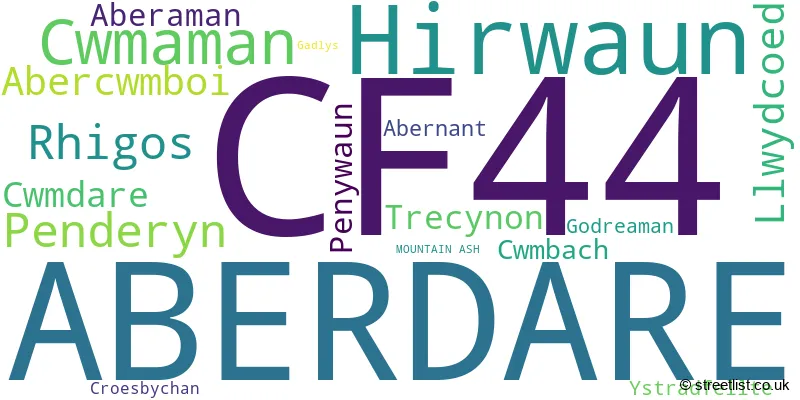
The largest settlement in the CF44 postal code is ABERDARE followed by HIRWAUN, and Aberaman.
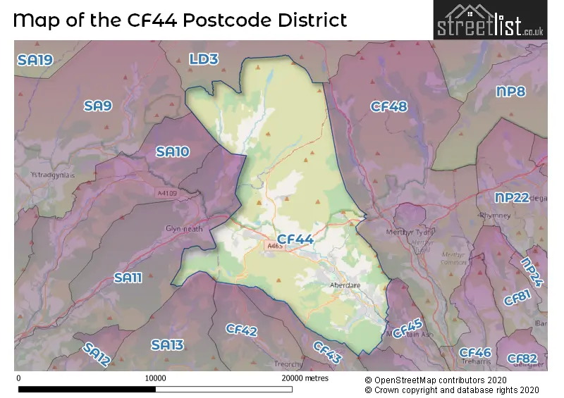
The CF44 Postcode shares a border with LD3 (BRECON, TALGARTH, LLAN-FAES), CF45 (MOUNTAIN ASH, ABERCYNON, Penrhiwceiber), CF48 (DOWLAIS, MERTHYR TYDFIL, TROEDYRHIW), SA11 (NEATH, Briton Ferry, GLYNNEATH), CF43 (FERNDALE, MAERDY, Tylorstown) and SA13 (PORT TALBOT, MARGAM, TAIBACH).
The primary settlement in the CF44 postcode district is Aberdare, located in the county of Mid Glamorgan, Wales. Other significant settlements include Aberaman, Abercwmboi, Cwmaman, and Hirwaun, all within Mid Glamorgan. The most significant post town in the postcode district is ABERDARE.
For the district CF44, we have data on 6 postcode sectors. Here's a breakdown: The sector CF44 0, covers Aberdare in Mid Glamorgan. The sector CF44 4 is non-geographic. It's often designated for PO Boxes, large organisations, or special services. The sector CF44 6, covers Aberdare and Cwmaman in Mid Glamorgan. The sector CF44 7, covers Aberdare in Mid Glamorgan. The sector CF44 8, covers Aberdare in Mid Glamorgan. The sector CF44 9, covers Hirwaun and Aberdare and Rhigos in Mid Glamorgan.

Map of the CF44 Postcode District
Explore the CF44 postcode district by using our free interactive map.
When it comes to local government, postal geography often disregards political borders. However, for a breakdown in the CF44 District: the district mostly encompasses the Rhondda Cynon Taf - Rhondda Cynon Taf (1004 postcodes), and finally, the Powys - Powys area (6 postcodes).
Weather Forecast for CF44
Press Button to Show Forecast for Ystradfellte Youth Hostel
| Time Period | Icon | Description | Temperature | Rain Probability | Wind |
|---|---|---|---|---|---|
| 12:00 to 15:00 | Overcast | 6.0°C (feels like 3.0°C) | 11.00% | ENE 11 mph | |
| 15:00 to 18:00 | Overcast | 7.0°C (feels like 4.0°C) | 11.00% | NE 11 mph | |
| 18:00 to 21:00 | Cloudy | 6.0°C (feels like 3.0°C) | 6.00% | NE 11 mph | |
| 21:00 to 00:00 | Cloudy | 5.0°C (feels like 2.0°C) | 9.00% | NE 9 mph |
Press Button to Show Forecast for Ystradfellte Youth Hostel
| Time Period | Icon | Description | Temperature | Rain Probability | Wind |
|---|---|---|---|---|---|
| 00:00 to 03:00 | Cloudy | 4.0°C (feels like 1.0°C) | 10.00% | NNE 11 mph | |
| 03:00 to 06:00 | Cloudy | 4.0°C (feels like 0.0°C) | 13.00% | N 11 mph | |
| 06:00 to 09:00 | Overcast | 4.0°C (feels like 0.0°C) | 17.00% | N 9 mph | |
| 09:00 to 12:00 | Cloudy | 6.0°C (feels like 3.0°C) | 11.00% | NNW 9 mph | |
| 12:00 to 15:00 | Overcast | 8.0°C (feels like 6.0°C) | 14.00% | NW 9 mph | |
| 15:00 to 18:00 | Cloudy | 9.0°C (feels like 7.0°C) | 8.00% | WNW 11 mph | |
| 18:00 to 21:00 | Sunny day | 8.0°C (feels like 6.0°C) | 1.00% | W 9 mph | |
| 21:00 to 00:00 | Partly cloudy (night) | 4.0°C (feels like 2.0°C) | 1.00% | WSW 4 mph |
Press Button to Show Forecast for Ystradfellte Youth Hostel
| Time Period | Icon | Description | Temperature | Rain Probability | Wind |
|---|---|---|---|---|---|
| 00:00 to 03:00 | Clear night | 4.0°C (feels like 1.0°C) | 2.00% | SSW 7 mph | |
| 03:00 to 06:00 | Cloudy | 4.0°C (feels like 2.0°C) | 7.00% | SSW 7 mph | |
| 06:00 to 09:00 | Cloudy | 5.0°C (feels like 3.0°C) | 7.00% | S 7 mph | |
| 09:00 to 12:00 | Cloudy | 9.0°C (feels like 5.0°C) | 11.00% | S 13 mph | |
| 12:00 to 15:00 | Light rain | 10.0°C (feels like 7.0°C) | 45.00% | S 16 mph | |
| 15:00 to 18:00 | Cloudy | 10.0°C (feels like 7.0°C) | 17.00% | S 16 mph | |
| 18:00 to 21:00 | Partly cloudy (day) | 9.0°C (feels like 6.0°C) | 14.00% | S 13 mph | |
| 21:00 to 00:00 | Cloudy | 8.0°C (feels like 5.0°C) | 16.00% | SSE 11 mph |
Press Button to Show Forecast for Ystradfellte Youth Hostel
| Time Period | Icon | Description | Temperature | Rain Probability | Wind |
|---|---|---|---|---|---|
| 00:00 to 03:00 | Cloudy | 7.0°C (feels like 4.0°C) | 18.00% | SSE 11 mph | |
| 03:00 to 06:00 | Partly cloudy (night) | 7.0°C (feels like 3.0°C) | 17.00% | SE 11 mph | |
| 06:00 to 09:00 | Light rain shower (day) | 7.0°C (feels like 4.0°C) | 37.00% | SE 11 mph | |
| 09:00 to 12:00 | Cloudy | 9.0°C (feels like 6.0°C) | 19.00% | SE 13 mph | |
| 12:00 to 15:00 | Cloudy | 12.0°C (feels like 9.0°C) | 18.00% | SE 16 mph | |
| 15:00 to 18:00 | Cloudy | 12.0°C (feels like 9.0°C) | 23.00% | SE 13 mph | |
| 18:00 to 21:00 | Cloudy | 11.0°C (feels like 9.0°C) | 19.00% | SE 9 mph | |
| 21:00 to 00:00 | Cloudy | 8.0°C (feels like 7.0°C) | 11.00% | ESE 7 mph |
Where is the CF44 Postcode District?
The CF44 postcode district is located in Aberdare, a town in Wales. It is situated near several towns including Merthyr Tydfil to the east, Treorchy to the south, and Mountain Ash to the southeast. Additionally, the distance from Aberdare to London is approximately 146.35 miles.
The district is within the post town of ABERDARE.
The sector has postcodes within the nation of Wales.
The CF44 Postcode District is covers the following regions.
- Central Valleys - West Wales - Wales
- Powys - East Wales - Wales
| Postcode Sector | Delivery Office |
|---|---|
| CF44 0 | Aberdare Delivery Office |
| CF44 6 | Aberdare Delivery Office |
| CF44 7 | Aberdare Delivery Office |
| CF44 8 | Aberdare Delivery Office |
| CF44 9 | Aberdare Delivery Office |
| C | F | 4 | 4 | - | X | X | X |
| C | F | 4 | 4 | Space | Numeric | Letter | Letter |
Current Monthly Rental Prices
| # Bedrooms | Min Price | Max Price | Avg Price |
|---|---|---|---|
| 1 | £525 | £525 | £525 |
| 2 | £600 | £725 | £650 |
| 3 | £650 | £1,000 | £750 |
| 4 | £750 | £799 | £775 |
Current House Prices
| # Bedrooms | Min Price | Max Price | Avg Price |
|---|---|---|---|
| 2 | £475,000 | £475,000 | £475,000 |
| 3 | £439,995 | £439,995 | £439,995 |
| 4 | £385,000 | £795,000 | £487,940 |
| 5 | £400,000 | £730,000 | £593,750 |
| 6 | £735,000 | £750,000 | £742,500 |
Estate Agents who Operate in the CF44 District
| Logo | Name | Brand Name | Address | Contact Number | Total Properties |
|---|---|---|---|---|---|
 | Aberdare | Penhill Jones Property | Covering Aberdare | 01685 701268 | 64 |
 | Aberdare | Manning Estate Agents | Gloucester House, 29 Whitcombe Street, Aberdare, CF44 7AU | 01685 708683 | 39 |
 | Aberdare | Sophie Hill Estate Agents | Llwydcoed Road, Llwydcoed, Aberdare, CF44 0TN | 01685 708652 | 16 |
 | Aberdare | Ramsay & White Estate Agents | 27 a & b High Street Aberdare CF44 7AA | 01443 809418 | 13 |
 | Merthyr Tydfil | Martin & Co | 37 Victoria Street, Merthyr Tydfil, CF47 8BW | 01685 708682 | 4 |
| Type of Property | 2018 Average | 2018 Sales | 2017 Average | 2017 Sales | 2016 Average | 2016 Sales | 2015 Average | 2015 Sales |
|---|---|---|---|---|---|---|---|---|
| Detached | £207,702 | 115 | £187,866 | 113 | £192,664 | 150 | £189,031 | 162 |
| Semi-Detached | £123,675 | 141 | £113,562 | 125 | £114,181 | 124 | £109,255 | 168 |
| Terraced | £75,535 | 360 | £74,270 | 328 | £70,964 | 325 | £69,606 | 314 |
| Flats | £53,821 | 17 | £40,022 | 11 | £44,152 | 23 | £51,622 | 16 |