The CF10 postcode district is a postal district located in the CF Cardiff postcode area with a population of 17,423 residents according to the 2021 England and Wales Census.
The area of the CF10 postcode district is 3.16 square miles which is 8.18 square kilometres or 2,022.28 acres.
Currently, the CF10 district has about 632 postcode units spread across 5 geographic postcode sectors.
Given that each sector allows for 400 unique postcode combinations, the district has a capacity of 2,000 postcodes. With 632 postcodes already in use, this leaves 1368 units available.
The largest settlement in the CF10 postal code is BUTETOWN followed by CATHAYS, and ADAMSDOWN.
The postcode area has a boundary with The Bristol Channel.
The CF10 Postcode shares a border with CF11 (GRANGETOWN, RIVERSIDE, PONTCANNA), CF14 (WHITCHURCH, CARDIFF, GABALFA), CF24 (ROATH, CATHAYS, SPLOTT) and CF64 (PENARTH, DINAS POWYS, SULLY).
The CF10 postcode district primarily includes the settlement of Cardiff in the county of South Glamorgan, Wales. Other significant settlements within this postcode district include Blackweir and Butetown. The main post town associated with CF10 is Cardiff.
For the district CF10, we have data on 5 postcode sectors. Here's a breakdown: The sector CF10 1, covers Cardiff in South Glamorgan. The sector CF10 2, covers Cardiff in South Glamorgan. The sector CF10 3, covers Cardiff in South Glamorgan. The sector CF10 4, covers Cardiff in South Glamorgan. The sector CF10 5, covers Cardiff in South Glamorgan.

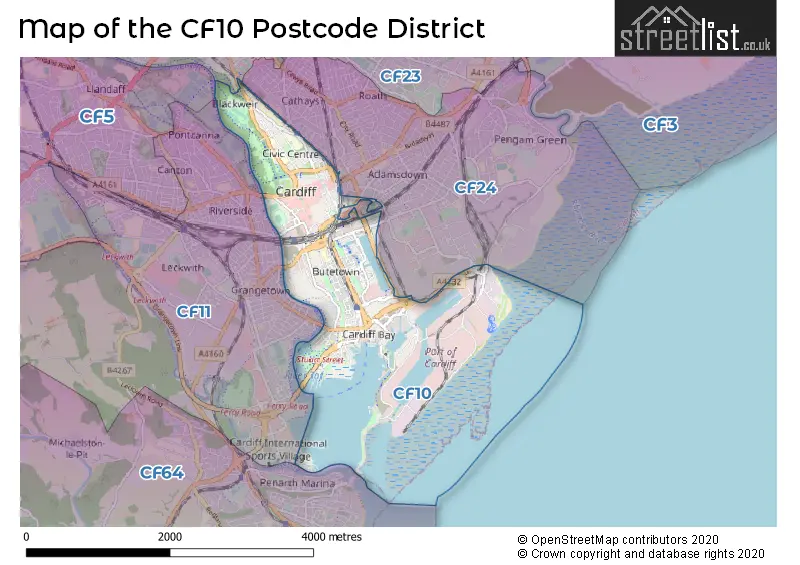
Map of the CF10 Postcode District
Explore the CF10 postcode district by using our free interactive map.
When it comes to local government, postal geography often disregards political borders. However, for a breakdown in the CF10 District: the district mostly encompasses the Caerdydd - Cardiff area with a total of 628 postcodes.
Weather Forecast for CF10
Press Button to Show Forecast for Millennium Stadium
| Time Period | Icon | Description | Temperature | Rain Probability | Wind |
|---|---|---|---|---|---|
| 15:00 to 18:00 | Overcast | 11.0°C (feels like 8.0°C) | 17.00% | E 9 mph | |
| 18:00 to 21:00 | Overcast | 10.0°C (feels like 8.0°C) | 18.00% | E 9 mph | |
| 21:00 to 00:00 | Overcast | 9.0°C (feels like 7.0°C) | 20.00% | E 9 mph |
Press Button to Show Forecast for Millennium Stadium
| Time Period | Icon | Description | Temperature | Rain Probability | Wind |
|---|---|---|---|---|---|
| 00:00 to 03:00 | Light rain | 8.0°C (feels like 5.0°C) | 57.00% | NE 11 mph | |
| 03:00 to 06:00 | Light rain | 7.0°C (feels like 3.0°C) | 56.00% | NE 11 mph | |
| 06:00 to 09:00 | Overcast | 6.0°C (feels like 2.0°C) | 18.00% | NE 13 mph | |
| 09:00 to 12:00 | Overcast | 7.0°C (feels like 3.0°C) | 13.00% | NE 13 mph | |
| 12:00 to 15:00 | Cloudy | 9.0°C (feels like 6.0°C) | 10.00% | NE 13 mph | |
| 15:00 to 18:00 | Overcast | 10.0°C (feels like 8.0°C) | 10.00% | NE 13 mph | |
| 18:00 to 21:00 | Overcast | 10.0°C (feels like 7.0°C) | 9.00% | NE 13 mph | |
| 21:00 to 00:00 | Cloudy | 8.0°C (feels like 5.0°C) | 8.00% | NNE 13 mph |
Press Button to Show Forecast for Millennium Stadium
| Time Period | Icon | Description | Temperature | Rain Probability | Wind |
|---|---|---|---|---|---|
| 00:00 to 03:00 | Cloudy | 8.0°C (feels like 4.0°C) | 11.00% | NNE 13 mph | |
| 03:00 to 06:00 | Light rain | 7.0°C (feels like 4.0°C) | 44.00% | N 13 mph | |
| 06:00 to 09:00 | Cloudy | 7.0°C (feels like 4.0°C) | 44.00% | N 9 mph | |
| 09:00 to 12:00 | Cloudy | 8.0°C (feels like 6.0°C) | 14.00% | NNW 11 mph | |
| 12:00 to 15:00 | Overcast | 11.0°C (feels like 8.0°C) | 15.00% | WNW 11 mph | |
| 15:00 to 18:00 | Cloudy | 11.0°C (feels like 9.0°C) | 9.00% | W 11 mph | |
| 18:00 to 21:00 | Partly cloudy (day) | 11.0°C (feels like 8.0°C) | 3.00% | W 13 mph | |
| 21:00 to 00:00 | Clear night | 9.0°C (feels like 7.0°C) | 0.00% | WSW 9 mph |
Press Button to Show Forecast for Millennium Stadium
| Time Period | Icon | Description | Temperature | Rain Probability | Wind |
|---|---|---|---|---|---|
| 00:00 to 03:00 | Clear night | 8.0°C (feels like 6.0°C) | 2.00% | SW 9 mph | |
| 03:00 to 06:00 | Partly cloudy (night) | 7.0°C (feels like 5.0°C) | 2.00% | S 9 mph | |
| 06:00 to 09:00 | Partly cloudy (day) | 8.0°C (feels like 5.0°C) | 2.00% | SSE 9 mph | |
| 09:00 to 12:00 | Partly cloudy (day) | 11.0°C (feels like 8.0°C) | 4.00% | S 13 mph | |
| 12:00 to 15:00 | Partly cloudy (day) | 12.0°C (feels like 9.0°C) | 7.00% | S 16 mph | |
| 15:00 to 18:00 | Cloudy | 13.0°C (feels like 10.0°C) | 9.00% | S 18 mph | |
| 18:00 to 21:00 | Partly cloudy (day) | 12.0°C (feels like 9.0°C) | 6.00% | SSE 16 mph | |
| 21:00 to 00:00 | Clear night | 10.0°C (feels like 8.0°C) | 6.00% | SSE 13 mph |
Press Button to Show Forecast for Millennium Stadium
| Time Period | Icon | Description | Temperature | Rain Probability | Wind |
|---|---|---|---|---|---|
| 00:00 to 03:00 | Cloudy | 10.0°C (feels like 7.0°C) | 10.00% | SE 13 mph | |
| 03:00 to 06:00 | Partly cloudy (night) | 10.0°C (feels like 7.0°C) | 7.00% | SE 13 mph | |
| 06:00 to 09:00 | Sunny day | 10.0°C (feels like 7.0°C) | 8.00% | SE 13 mph | |
| 09:00 to 12:00 | Cloudy | 12.0°C (feels like 9.0°C) | 13.00% | SE 16 mph | |
| 12:00 to 15:00 | Partly cloudy (day) | 14.0°C (feels like 11.0°C) | 13.00% | SE 16 mph | |
| 15:00 to 18:00 | Light rain shower (day) | 14.0°C (feels like 11.0°C) | 39.00% | SE 13 mph | |
| 18:00 to 21:00 | Partly cloudy (day) | 13.0°C (feels like 11.0°C) | 10.00% | SE 11 mph | |
| 21:00 to 00:00 | Partly cloudy (night) | 11.0°C (feels like 10.0°C) | 6.00% | SE 9 mph |
Where is the CF10 Postcode District?
The postcode district CF10 is located in Cardiff. It is the district town of Cardiff. Nearby towns include Penarth, which is located 2.8 miles south of CF10, Dinas Powys, which is located 3.2 miles southwest of CF10, Caerphilly, which is located 7.9 miles north of CF10, Pontyclun, which is located 10.1 miles northwest of CF10, Cowbridge, which is located 11.5 miles west of CF10, Newport, which is located 11.8 miles northeast of CF10, and Weston-super-Mare, which is located 12.5 miles southeast of CF10. Additionally, CF10 is approximately 131.2 miles away from London.
The district is within the post town of CARDIFF.
The sector has postcodes within the nation of Wales.
The CF10 Postcode District is in the Cardiff and Vale of Glamorgan region of East Wales within the Wales.
| Postcode Sector | Delivery Office |
|---|---|
| CF10 1 | Cardiff Delivery Office |
| CF10 2 | Cardiff Delivery Office |
| CF10 3 | Cardiff Delivery Office |
| CF10 4 | Cardiff Delivery Office |
| CF10 5 | Cardiff Delivery Office |
| C | F | 1 | 0 | - | X | X | X |
| C | F | 1 | 0 | Space | Numeric | Letter | Letter |
Tourist Attractions within the Postcode Area
We found 5 visitor attractions within the CF10 postcode area
| Craft in the Bay |
|---|
| View Craft in the Bay on Google Maps |
| Firing Line |
| View Firing Line on Google Maps |
| National Museum Cardiff |
| View National Museum Cardiff on Google Maps |
| Pierhead |
| View Pierhead on Google Maps |
| Senedd |
| View Senedd on Google Maps |
Current Monthly Rental Prices
| # Bedrooms | Min Price | Max Price | Avg Price |
|---|---|---|---|
| 1 | £3,000 | £4,000 | £3,400 |
| 2 | £2,750 | £6,000 | £3,565 |
| 3 | £2,510 | £3,700 | £3,185 |
| 4 | £2,500 | £2,500 | £2,500 |
Current House Prices
| # Bedrooms | Min Price | Max Price | Avg Price |
|---|---|---|---|
| £1,950,000 | £1,950,000 | £1,950,000 | |
| 2 | £285,000 | £550,000 | £437,231 |
| 3 | £299,950 | £360,000 | £330,700 |
| 4 | £350,000 | £350,000 | £350,000 |
| 5 | £750,000 | £750,000 | £750,000 |
| 6 | £1,100,000 | £1,100,000 | £1,100,000 |
| 13 | £900,000 | £900,000 | £900,000 |
Estate Agents who Operate in the CF10 District
| Logo | Name | Brand Name | Address | Contact Number | Total Properties |
|---|---|---|---|---|---|
 | Cardiff Bay | Taylors Estate Agents | Unit 16a Mermaid Quay Cardiff CF10 5BZ | 029 2002 8235 | 25 |
 | Cardiff | MGY | Column Buildings, 13 Mount Stuart Square, Cardiff, CF10 5EE | 029 2046 5466 | 22 |
 | Covering Nationwide | The Agency UK | Covering Nationwide | 020 3909 1509 | 19 |
 | Pontcanna | Allen & Harris | 209 Cathedral Road, Pontcanna, Cardiff, S Wales, CF11 9PN | 029 2271 6908 | 17 |
 | Canton | Peter Alan | 170 Cowbridge Road East, Cardiff, CF11 9NE | 029 2271 6271 | 14 |
| Type of Property | 2018 Average | 2018 Sales | 2017 Average | 2017 Sales | 2016 Average | 2016 Sales | 2015 Average | 2015 Sales |
|---|---|---|---|---|---|---|---|---|
| Detached | £307,300 | 3 | £550,833 | 3 | £0 | 0 | £458,750 | 2 |
| Semi-Detached | £225,333 | 6 | £316,083 | 12 | £304,500 | 6 | £145,857 | 7 |
| Terraced | £266,162 | 34 | £248,375 | 32 | £216,726 | 35 | £188,169 | 37 |
| Flats | £168,106 | 375 | £166,885 | 368 | £160,911 | 351 | £153,078 | 408 |