The CF42 5 postcode sector stands on the Mid Glamorgan and West Glamorgan border.
Did you know? According to the 2021 Census, the CF42 5 postcode sector is home to a bustling 5,981 residents!
Given that each sector allows for 400 unique postcode combinations. Letters C, I, K, M, O and V are not allowed in the last two letters of a postcode. With 146 postcodes already in use, this leaves 254 units available.
The largest settlement in the CF42 5 postal code is Treherbert followed by TYNEWYDD, and BLAENRHONDDA.
The CF42 5 Postcode shares a border with SA13 3 (CYMMER, GLYNCORRWG, CROESERW), CF42 6 (TREORCHY, CWM-PARC, YNYS-WEN), CF43 4 (FERNDALE, MAERDY, Blaenllechau) and CF44 9 (HIRWAUN, ABERDARE, RHIGOS).
The sector is within the post town of TREORCHY.
CF42 5 is a postcode sector within the CF42 postcode district which is within the CF Cardiff postcode area.
The Royal Mail delivery office for the CF42 5 postal sector is the Treorchy Delivery Office.
The area of the CF42 5 postcode sector is 8.33 square miles which is 21.58 square kilometres or 5,331.97 square acres.


Map of the CF42 5 Postcode Sector
Explore the CF42 5 postcode sector by using our free interactive map.
| C | F | 4 | 2 | - | 5 | X | X |
| C | F | 4 | 2 | Space | 5 | Letter | Letter |
Official List of Streets
Treherbert (71 Streets)
Blaenrhondda (7 Streets)
Blaencwm (8 Streets)
Unofficial Streets or Alternative Spellings
Treherbert
AEL-Y-BRYN BLAEN-Y-CWM TERRACE TYN-Y-COEDCAE BRYN HENLLAN BRYN HEULOG BRYN RHEDYN CW RT-YR-YSGOL DELWEN TERRACE EMMANUEL CLOSE GLENRHONDDA COURT RHIGOS ROAD SAINT MARYS CLOSE T?N Y COEDCAE TWYN-YR-EOS TYLE-FFORESTBlaenrhondda
PEN-PYCH CLOSE TAN-Y-PYCHBlaencwm
BLAEN-Y-CWM ROAD GRAIG-Y-DDELWTREORCHY
KENRY STREET YNYSWEN ROAD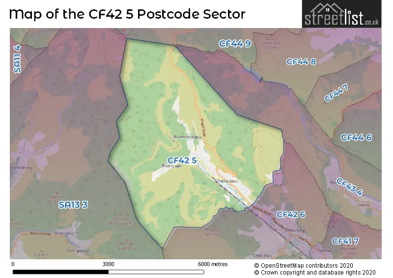
House Prices in the CF42 5 Postcode Sector
| Type of Property | 2018 Average | 2018 Sales | 2017 Average | 2017 Sales | 2016 Average | 2016 Sales | 2015 Average | 2015 Sales |
|---|---|---|---|---|---|---|---|---|
| Detached | £85,000 | 2 | £0 | 0 | £99,500 | 2 | £187,750 | 2 |
| Semi-Detached | £82,540 | 5 | £87,248 | 8 | £120,583 | 6 | £58,750 | 4 |
| Terraced | £61,762 | 90 | £57,749 | 97 | £51,003 | 62 | £57,358 | 67 |
| Flats | £0 | 0 | £36,750 | 2 | £40,000 | 1 | £87,500 | 2 |
Important Postcodes CF42 5 in the Postcode Sector
CF42 5AW is the postcode for PENYRENGLYN COMMUNITY PRIMARY SCHOOL, BAGLAN STREET, TREHERBERT, and Penyrenglyn Community Primary School, Baglan Street
CF42 5PN is the postcode for Treherbert Community Education Centre, Dumfries Street
CF42 5SD is the postcode for Pen-y-Pych Community Primary School, Blaenrhondda Road, Pen-y-Pych Community Primary School, Blaenrhondda Road, Blaenrhondda, and Pen Y Pych Community Primary School, Blaenrhondda Road
| The CF42 5 Sector is within these Local Authorities |
|
|---|---|
| The CF42 5 Sector is within these Counties |
|
| The CF42 5 Sector is within these Water Company Areas |
|