The CF61 2 postcode sector is within the county of South Glamorgan.
Did you know? According to the 2021 Census, the CF61 2 postcode sector is home to a bustling 4,898 residents!
Given that each sector allows for 400 unique postcode combinations. Letters C, I, K, M, O and V are not allowed in the last two letters of a postcode. With 84 postcodes already in use, this leaves 316 units available.
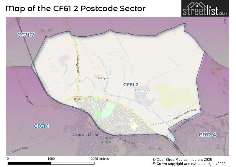
The largest settlement in the CF61 2 postal code is LLANTWIT MAJOR followed by BOVERTON, and LLANMAES.
The CF61 2 Postcode shares a border with CF62 4 (ST ATHAN, EGLWYS-BREWIS, GILESTON), CF61 1 (LLANTWIT MAJOR, BOVERTON, ST DONATS) and CF71 7 (COWBRIDGE, WICK, LLANBLETHIAN).
The sector is within the post town of LLANTWIT MAJOR.
CF61 2 is a postcode sector within the CF61 postcode district which is within the CF Cardiff postcode area.
The Royal Mail delivery office for the CF61 2 postal sector is the Vale Of Glamorgan Delivery Office.
The area of the CF61 2 postcode sector is 2.90 square miles which is 7.52 square kilometres or 1,857.11 square acres.


Map of the CF61 2 Postcode Sector
Explore the CF61 2 postcode sector by using our free interactive map.
| C | F | 6 | 1 | - | 2 | X | X |
| C | F | 6 | 1 | Space | 2 | Letter | Letter |
Official List of Streets
Boverton (28 Streets)
LLANTWIT MAJOR (40 Streets)
Unofficial Streets or Alternative Spellings
House Prices in the CF61 2 Postcode Sector
| Type of Property | 2018 Average | 2018 Sales | 2017 Average | 2017 Sales | 2016 Average | 2016 Sales | 2015 Average | 2015 Sales |
|---|---|---|---|---|---|---|---|---|
| Detached | £340,952 | 29 | £281,678 | 25 | £266,185 | 29 | £298,625 | 28 |
| Semi-Detached | £186,321 | 26 | £187,905 | 21 | £174,803 | 18 | £176,314 | 22 |
| Terraced | £146,677 | 24 | £144,519 | 25 | £143,096 | 24 | £128,719 | 26 |
| Flats | £0 | 0 | £0 | 0 | £79,000 | 1 | £67,333 | 3 |
Important Postcodes CF61 2 in the Postcode Sector
CF61 2UE is the postcode for INFANT SCHOOL, Eagleswell Primary School, Eagleswell Road, YSGOL Y DDRAIG, Eagleswell Primary School, Eagleswell Road, JUNIOR SCHOOL, Eagleswell Primary School, Eagleswell Road, and Eagleswell Primary School, Eagleswell Road
| The CF61 2 Sector is within these Local Authorities |
|
|---|---|
| The CF61 2 Sector is within these Counties |
|
| The CF61 2 Sector is within these Water Company Areas |
|