The CH47 postcode district is a postal district located in the CH Chester postcode area with a population of 10,819 residents according to the 2021 England and Wales Census.
The area of the CH47 postcode district is 2.94 square miles which is 7.61 square kilometres or 1,880.21 acres.
Currently, the CH47 district has about 342 postcode units spread across 10 geographic postcode sectors.
Given that each sector allows for 400 unique postcode combinations, the district has a capacity of 4,000 postcodes. With 342 postcodes already in use, this leaves 3658 units available.
The largest settlement in the CH47 postal code is WIRRAL followed by Hoylake, and Meols.
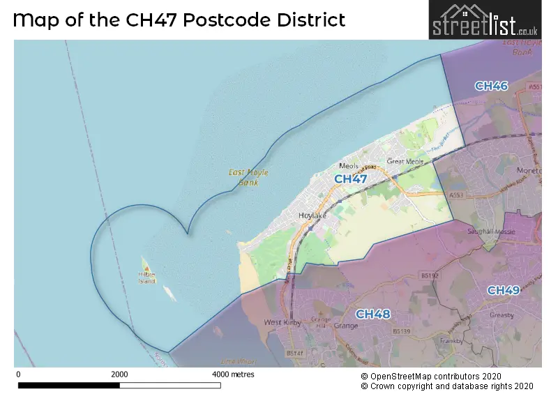
The postcode area has a boundary with Dee Estuary and The Irish Sea.
The CH47 Postcode shares a border with CH48 (West Kirby, WIRRAL, Caldy) and CH46 (WIRRAL, Moreton).
In the CH47 postcode district, the primary settlement is Wirral in the county of Merseyside, which has the highest count. Other significant settlements include Hoylake and Meols, also located in the county of Merseyside. The most significant post town is Wirral.
For the district CH47, we have data on 10 postcode sectors. Here's a breakdown: The sector CH47 0, covers Wirral and Meols in Merseyside. The sector CH47 1, covers Hoylake and Wirral in Merseyside. The sector CH47 2, covers Wirral and Hoylake in Merseyside. The sector CH47 3, covers Wirral and Hoylake in Merseyside. The sector CH47 4, covers Hoylake and Wirral in Merseyside. The sector CH47 5, covers Wirral and Meols in Merseyside. The sector CH47 6, covers Wirral and Meols in Merseyside. The sector CH47 7, covers Wirral and Meols and Hoylake in Merseyside. The sector CH47 8, covers Wirral and Meols in Merseyside. The sector CH47 9, covers Meols and Wirral in Merseyside.

Map of the CH47 Postcode District
Explore the CH47 postcode district by using our free interactive map.
When it comes to local government, postal geography often disregards political borders. However, for a breakdown in the CH47 District: the district mostly encompasses the Wirral District (B) area with a total of 342 postcodes.
Weather Forecast for CH47
Press Button to Show Forecast for Hoylake
| Time Period | Icon | Description | Temperature | Rain Probability | Wind |
|---|---|---|---|---|---|
| 18:00 to 21:00 | Light rain | 8.0°C (feels like 6.0°C) | 49.00% | NNE 9 mph | |
| 21:00 to 00:00 | Cloudy | 7.0°C (feels like 5.0°C) | 14.00% | NE 7 mph |
Press Button to Show Forecast for Hoylake
| Time Period | Icon | Description | Temperature | Rain Probability | Wind |
|---|---|---|---|---|---|
| 00:00 to 03:00 | Cloudy | 7.0°C (feels like 4.0°C) | 6.00% | E 7 mph | |
| 03:00 to 06:00 | Cloudy | 6.0°C (feels like 4.0°C) | 6.00% | E 7 mph | |
| 06:00 to 09:00 | Cloudy | 6.0°C (feels like 3.0°C) | 5.00% | E 9 mph | |
| 09:00 to 12:00 | Cloudy | 8.0°C (feels like 6.0°C) | 6.00% | E 9 mph | |
| 12:00 to 15:00 | Cloudy | 10.0°C (feels like 8.0°C) | 7.00% | NE 9 mph | |
| 15:00 to 18:00 | Light rain | 9.0°C (feels like 7.0°C) | 49.00% | ENE 9 mph | |
| 18:00 to 21:00 | Overcast | 9.0°C (feels like 7.0°C) | 10.00% | NE 11 mph | |
| 21:00 to 00:00 | Cloudy | 8.0°C (feels like 6.0°C) | 5.00% | ENE 9 mph |
Press Button to Show Forecast for Hoylake
| Time Period | Icon | Description | Temperature | Rain Probability | Wind |
|---|---|---|---|---|---|
| 00:00 to 03:00 | Cloudy | 7.0°C (feels like 4.0°C) | 4.00% | NE 9 mph | |
| 03:00 to 06:00 | Cloudy | 6.0°C (feels like 3.0°C) | 4.00% | NNE 11 mph | |
| 06:00 to 09:00 | Cloudy | 7.0°C (feels like 4.0°C) | 8.00% | NNE 11 mph | |
| 09:00 to 12:00 | Cloudy | 8.0°C (feels like 6.0°C) | 10.00% | NNW 11 mph | |
| 12:00 to 15:00 | Partly cloudy (day) | 9.0°C (feels like 7.0°C) | 8.00% | NW 13 mph | |
| 15:00 to 18:00 | Sunny day | 10.0°C (feels like 7.0°C) | 6.00% | WNW 13 mph | |
| 18:00 to 21:00 | Sunny day | 10.0°C (feels like 8.0°C) | 2.00% | W 11 mph | |
| 21:00 to 00:00 | Clear night | 9.0°C (feels like 6.0°C) | 1.00% | SW 11 mph |
Press Button to Show Forecast for Hoylake
| Time Period | Icon | Description | Temperature | Rain Probability | Wind |
|---|---|---|---|---|---|
| 00:00 to 03:00 | Partly cloudy (night) | 8.0°C (feels like 5.0°C) | 1.00% | SSW 11 mph | |
| 03:00 to 06:00 | Cloudy | 7.0°C (feels like 4.0°C) | 5.00% | S 11 mph | |
| 06:00 to 09:00 | Cloudy | 7.0°C (feels like 4.0°C) | 7.00% | SSE 13 mph | |
| 09:00 to 12:00 | Partly cloudy (day) | 11.0°C (feels like 8.0°C) | 2.00% | SSE 16 mph | |
| 12:00 to 15:00 | Cloudy | 13.0°C (feels like 10.0°C) | 8.00% | S 16 mph | |
| 15:00 to 18:00 | Overcast | 13.0°C (feels like 10.0°C) | 13.00% | S 16 mph | |
| 18:00 to 21:00 | Partly cloudy (day) | 13.0°C (feels like 10.0°C) | 6.00% | SSE 16 mph | |
| 21:00 to 00:00 | Partly cloudy (night) | 11.0°C (feels like 8.0°C) | 2.00% | SSE 16 mph |
Press Button to Show Forecast for Hoylake
| Time Period | Icon | Description | Temperature | Rain Probability | Wind |
|---|---|---|---|---|---|
| 00:00 to 03:00 | Partly cloudy (night) | 9.0°C (feels like 6.0°C) | 3.00% | SE 13 mph | |
| 03:00 to 06:00 | Cloudy | 8.0°C (feels like 5.0°C) | 7.00% | SE 13 mph | |
| 06:00 to 09:00 | Cloudy | 9.0°C (feels like 6.0°C) | 7.00% | SE 13 mph | |
| 09:00 to 12:00 | Sunny day | 12.0°C (feels like 9.0°C) | 4.00% | SE 16 mph | |
| 12:00 to 15:00 | Partly cloudy (day) | 15.0°C (feels like 11.0°C) | 7.00% | SE 16 mph | |
| 15:00 to 18:00 | Cloudy | 15.0°C (feels like 12.0°C) | 12.00% | SE 13 mph | |
| 18:00 to 21:00 | Cloudy | 14.0°C (feels like 12.0°C) | 8.00% | SE 11 mph | |
| 21:00 to 00:00 | Cloudy | 12.0°C (feels like 10.0°C) | 7.00% | ESE 11 mph |
Where is the CH47 Postcode District?
The data indicates that the postcode district CH47 is located in the town of Wirral. Wirral is a district town that has several nearby towns surrounding it. To the East of Wirral, there is Prenton, which is approximately 4.31 miles away. To the South West, there is Holywell, which is approximately 7.94 miles away. To the South East, there is Neston, approximately 8.20 miles away. To the North East, there is Bootle, approximately 8.99 miles away. Finally, to the South, there is Bagillt, which is approximately 9.01 miles away. Additionally, Wirral is situated approximately 182.92 miles away from the center of London.
The district is within the post town of WIRRAL.
The sector has postcodes within the nation of England.
The CH47 Postcode District is in the Wirral region of Merseyside within the North West (England).
Postcode Sectors within the CH47 District
| Postcode Sector | Delivery Office |
|---|---|
| CH47 0 | Hoylake Delivery Office |
| CH47 1 | Hoylake Delivery Office |
| CH47 2 | Hoylake Delivery Office |
| CH47 3 | Hoylake Delivery Office |
| CH47 4 | Hoylake Delivery Office |
| CH47 5 | Hoylake Delivery Office |
| CH47 6 | Hoylake Delivery Office |
| CH47 7 | Hoylake Delivery Office |
| CH47 8 | Hoylake Delivery Office |
| CH47 9 | Hoylake Delivery Office |
| C | H | 4 | 7 | - | X | X | X |
| C | H | 4 | 7 | Space | Numeric | Letter | Letter |
Current Monthly Rental Prices
| # Bedrooms | Min Price | Max Price | Avg Price |
|---|---|---|---|
| 1 | £650 | £650 | £650 |
| 2 | £775 | £775 | £775 |
| 3 | £1,100 | £1,150 | £1,125 |
| 5 | £1,750 | £1,750 | £1,750 |
Current House Prices
| # Bedrooms | Min Price | Max Price | Avg Price |
|---|---|---|---|
| £695,000 | £735,000 | £715,000 | |
| 2 | £675,000 | £675,000 | £675,000 |
| 3 | £695,000 | £695,000 | £695,000 |
| 4 | £595,000 | £830,000 | £660,990 |
| 5 | £750,000 | £1,000,000 | £875,000 |
| 6 | £588,000 | £1,200,000 | £796,000 |
| 7 | £640,000 | £1,150,000 | £838,333 |
Estate Agents who Operate in the CH47 District
| Logo | Name | Brand Name | Address | Contact Number | Total Properties |
|---|---|---|---|---|---|
 | West Kirby | Karl Tatler Estate Agents | 9 Banks Road West Kirby CH48 0QX | 0151 625 9300 | 39 |
 | Wirral | Market St Homes | 38 Market Street, Hoylake, CH47 2AF | 0151 632 5500 | 26 |
 | West Kirby | Bradshaw Farnham & Lea | 18 The Crescent, West Kirby, Wirral, CH48 4HN | 0151 453 4193 | 18 |
 | Hoylake | Jones & Chapman | 34 Market Street, Hoylake, CH47 2AF | 0151 453 3305 | 10 |
 | Wirral | Home Estate Agents | 42 Grange Road, West Kirby, CH48 4EF | 0151 453 0973 | 6 |
| Type of Property | 2018 Average | 2018 Sales | 2017 Average | 2017 Sales | 2016 Average | 2016 Sales | 2015 Average | 2015 Sales |
|---|---|---|---|---|---|---|---|---|
| Detached | £438,055 | 38 | £419,778 | 45 | £459,224 | 37 | £409,869 | 29 |
| Semi-Detached | £287,571 | 56 | £293,188 | 82 | £295,025 | 73 | £269,206 | 60 |
| Terraced | £208,125 | 65 | £206,904 | 59 | £221,066 | 40 | £212,924 | 43 |
| Flats | £204,539 | 56 | £186,039 | 48 | £175,401 | 49 | £144,873 | 52 |