The CH60 8 postcode sector stands on the Cheshire and Merseyside border.
Did you know? According to the 2021 Census, the CH60 8 postcode sector is home to a bustling 1,183 residents!
Given that each sector allows for 400 unique postcode combinations. Letters C, I, K, M, O and V are not allowed in the last two letters of a postcode. With 51 postcodes already in use, this leaves 349 units available.
The largest settlements in the CH60 8 postal code are WIRRAL and Heswall.
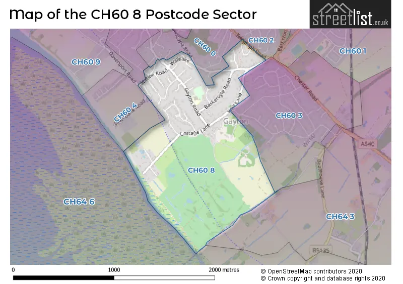
The CH60 8 Postcode shares a border with CH60 3 (WIRRAL, Heswall), CH64 6 (Parkgate, NESTON), CH64 3 (NESTON, Clayhill Light Industrial Park, Parkgate), CH60 0 (WIRRAL, Heswall), CH60 2 (WIRRAL, Heswall) and CH60 4 (WIRRAL, Heswall).
The sector is within the post town of WIRRAL.
CH60 8 is a postcode sector within the CH6 postcode district which is within the CH Chester postcode area.
The Royal Mail delivery office for the CH60 8 postal sector is the unknown.
The area of the CH60 8 postcode sector is 0.69 square miles which is 1.79 square kilometres or 443.25 square acres.

Map of the CH60 8 Postcode Sector
Explore the CH60 8 postcode sector by using our free interactive map.
| C | H | 6 | 0 | - | 8 | X | X |
| C | H | 6 | 0 | Space | 8 | Letter | Letter |
Official List of Streets
WIRRAL (19 Streets)
Heswall (11 Streets)
Unofficial Streets or Alternative Spellings
House Prices in the CH60 8 Postcode Sector
| Type of Property | 2018 Average | 2018 Sales | 2017 Average | 2017 Sales | 2016 Average | 2016 Sales | 2015 Average | 2015 Sales |
|---|---|---|---|---|---|---|---|---|
| Detached | £514,389 | 9 | £557,043 | 23 | £531,079 | 12 | £474,085 | 17 |
| Semi-Detached | £657,500 | 2 | £400,000 | 2 | £270,000 | 1 | £0 | 0 |
| Terraced | £307,000 | 1 | £325,000 | 1 | £326,650 | 3 | £0 | 0 |
| Flats | £0 | 0 | £230,000 | 1 | £0 | 0 | £175,000 | 1 |
Important Postcodes CH60 8 in the Postcode Sector
CH60 8PZ is the postcode for Gayton Primary School, 24 Gayton Road
| The CH60 8 Sector is within these Local Authorities |
|
|---|---|
| The CH60 8 Sector is within these Counties |
|
| The CH60 8 Sector is within these Water Company Areas |
|