The CH65 8 postcode sector is within the county of Cheshire.
Did you know? According to the 2021 Census, the CH65 8 postcode sector is home to a bustling 4,840 residents!
Given that each sector allows for 400 unique postcode combinations. Letters C, I, K, M, O and V are not allowed in the last two letters of a postcode. With 104 postcodes already in use, this leaves 296 units available.
The CH65 8 postal code covers the settlement of ELLESMERE PORT.
The CH65 8 Postcode shares a border with CH65 0 (ELLESMERE PORT), CH65 6 (Whitby, ELLESMERE PORT), CH65 2 (ELLESMERE PORT), CH65 3 (ELLESMERE PORT), CH65 4 (ELLESMERE PORT), CH65 7 (Great Sutton, Whitby, ELLESMERE PORT), CH66 1 (ELLESMERE PORT, Little Sutton, Childer Thornton) and CH66 3 (Great Sutton, Little Sutton, ELLESMERE PORT).
The sector is within the post town of ELLESMERE PORT.
CH65 8 is a postcode sector within the CH6 postcode district which is within the CH Chester postcode area.
The Royal Mail delivery office for the CH65 8 postal sector is the unknown.
The area of the CH65 8 postcode sector is 0.28 square miles which is 0.73 square kilometres or 181.18 square acres.

Map of the CH65 8 Postcode Sector
Explore the CH65 8 postcode sector by using our free interactive map.
| C | H | 6 | 5 | - | 8 | X | X |
| C | H | 6 | 5 | Space | 8 | Letter | Letter |
Official List of Streets
ELLESMERE PORT (50 Streets)
Unofficial Streets or Alternative Spellings
ELLESMERE PORT
BELGRAVE DRIVE CAMBRIDGE ROAD LUTON ROAD SUMMER CLOSEWhitby
POOLTOWN ROAD WHITBY ROAD SCHOOL ROAD SERVITE CLOSEGreat Sutton
OVERPOOL ROAD SUTTON WAY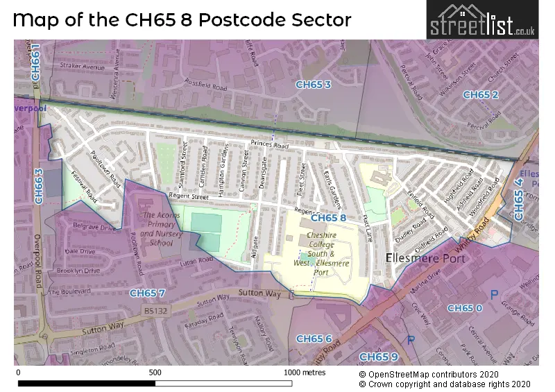
House Prices in the CH65 8 Postcode Sector
| Type of Property | 2018 Average | 2018 Sales | 2017 Average | 2017 Sales | 2016 Average | 2016 Sales | 2015 Average | 2015 Sales |
|---|---|---|---|---|---|---|---|---|
| Detached | £183,495 | 2 | £188,330 | 3 | £0 | 0 | £0 | 0 |
| Semi-Detached | £140,311 | 38 | £109,425 | 23 | £97,857 | 14 | £94,786 | 14 |
| Terraced | £112,059 | 69 | £80,306 | 35 | £78,334 | 36 | £76,632 | 34 |
| Flats | £0 | 0 | £0 | 0 | £0 | 0 | £75,750 | 4 |
Important Postcodes CH65 8 in the Postcode Sector
CH65 8DH is the postcode for William Stockton Cp School, Heathfield Road, and WILLIAM STOCKTON COMMUNITY SCHOOL, HEATHFIELD ROAD, ELLESMERE PORT
CH65 8HL is the postcode for The Acorns Primary School (Infants and Nursery), Regent Street, and Atherton County Infant School, Regent Street
| The CH65 8 Sector is within these Local Authorities |
|
|---|---|
| The CH65 8 Sector is within these Counties |
|
| The CH65 8 Sector is within these Water Company Areas |
|