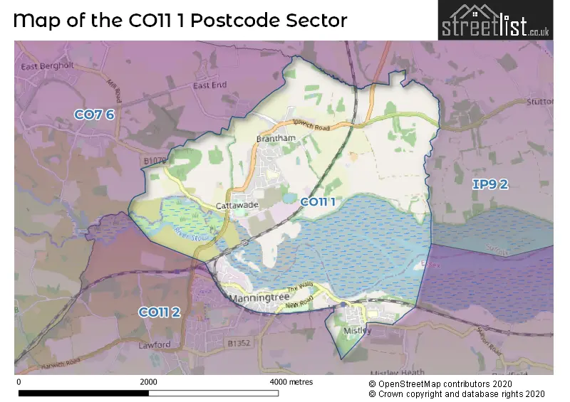
The CO11 1 postcode sector stands on the Essex and Suffolk border.
Did you know? According to the 2021 Census, the CO11 1 postcode sector is home to a bustling 5,617 residents!
Given that each sector allows for 400 unique postcode combinations. Letters C, I, K, M, O and V are not allowed in the last two letters of a postcode. With 254 postcodes already in use, this leaves 146 units available.
The largest settlement in the CO11 1 postal code is Brantham followed by Mistley, and MANNINGTREE.
The CO11 1 Postcode shares a border with CO11 2 (Lawford, Mistley, Bradfield), CO7 6 (East Bergholt, Dedham, Stratford St. Mary) and IP9 2 (Capel St. Mary, Holbrook, Stutton).
The sector is within the post town of MANNINGTREE.
CO11 1 is a postcode sector within the CO1 postcode district which is within the CO Colchester postcode area.
The Royal Mail delivery office for the CO11 1 postal sector is the Colchester Delivery Office.
The area of the CO11 1 postcode sector is 4.04 square miles which is 10.46 square kilometres or 2,585.17 square acres.
Waterways within the CO11 1 postcode sector include the River Stour.

Map of the CO11 1 Postcode Sector
Explore the CO11 1 postcode sector by using our free interactive map.
| C | O | 1 | 1 | - | 1 | X | X |
| C | O | 1 | 1 | Space | 1 | Letter | Letter |
Official List of Streets
MANNINGTREE (25 Streets)
Mistley (30 Streets)
Brantham (49 Streets)
Cattawade (3 Streets)
Lawford (14 Streets)
Unofficial Streets or Alternative Spellings
Mistley
GREEN LANE BENDALLS COURT BROOKS MALTING CENTRAL MALTINGS DAZELEYS LANE EAST END LANE EILEEN JACKSON PATH ENGLISH TERRACE GREENSMILL HENLEY COURT MIRRIAM CLOSE MISTLEY PLACE WALK NEWMILL LANE PARSONS YARD PLEASANT PLACE SAINT MICHAELS COURT THE WHITE BRIDGEMANNINGTREE
WHERRY CORNEREast Bergholt
MANNINGTREE ROAD PARK ROAD THE DRIFTWeather Forecast for CO11 1
Press Button to Show Forecast for Mistley
| Time Period | Icon | Description | Temperature | Rain Probability | Wind |
|---|---|---|---|---|---|
| 12:00 to 15:00 | Partly cloudy (day) | 15.0°C (feels like 11.0°C) | 0.00% | S 18 mph | |
| 15:00 to 18:00 | Sunny day | 15.0°C (feels like 11.0°C) | 0.00% | S 18 mph | |
| 18:00 to 21:00 | Sunny day | 13.0°C (feels like 11.0°C) | 0.00% | S 11 mph | |
| 21:00 to 00:00 | Clear night | 9.0°C (feels like 8.0°C) | 0.00% | SSE 7 mph |
Press Button to Show Forecast for Mistley
| Time Period | Icon | Description | Temperature | Rain Probability | Wind |
|---|---|---|---|---|---|
| 00:00 to 03:00 | Clear night | 9.0°C (feels like 7.0°C) | 0.00% | SE 7 mph | |
| 03:00 to 06:00 | Partly cloudy (night) | 8.0°C (feels like 7.0°C) | 1.00% | ESE 7 mph | |
| 06:00 to 09:00 | Sunny day | 11.0°C (feels like 10.0°C) | 1.00% | SE 4 mph | |
| 09:00 to 12:00 | Cloudy | 14.0°C (feels like 12.0°C) | 7.00% | SE 9 mph | |
| 12:00 to 15:00 | Cloudy | 14.0°C (feels like 12.0°C) | 8.00% | SE 11 mph | |
| 15:00 to 18:00 | Cloudy | 15.0°C (feels like 13.0°C) | 7.00% | SSE 11 mph | |
| 18:00 to 21:00 | Cloudy | 14.0°C (feels like 12.0°C) | 13.00% | SE 7 mph | |
| 21:00 to 00:00 | Light rain | 12.0°C (feels like 11.0°C) | 55.00% | ESE 7 mph |
Press Button to Show Forecast for Mistley
| Time Period | Icon | Description | Temperature | Rain Probability | Wind |
|---|---|---|---|---|---|
| 00:00 to 03:00 | Cloudy | 11.0°C (feels like 10.0°C) | 12.00% | SE 4 mph | |
| 03:00 to 06:00 | Cloudy | 10.0°C (feels like 9.0°C) | 14.00% | S 4 mph | |
| 06:00 to 09:00 | Mist | 11.0°C (feels like 10.0°C) | 18.00% | NNE 4 mph | |
| 09:00 to 12:00 | Cloudy | 14.0°C (feels like 13.0°C) | 9.00% | NE 7 mph | |
| 12:00 to 15:00 | Cloudy | 17.0°C (feels like 16.0°C) | 9.00% | ENE 7 mph | |
| 15:00 to 18:00 | Cloudy | 17.0°C (feels like 16.0°C) | 7.00% | ENE 9 mph | |
| 18:00 to 21:00 | Cloudy | 15.0°C (feels like 14.0°C) | 6.00% | NNW 9 mph | |
| 21:00 to 00:00 | Overcast | 12.0°C (feels like 11.0°C) | 12.00% | NNW 11 mph |
Press Button to Show Forecast for Mistley
| Time Period | Icon | Description | Temperature | Rain Probability | Wind |
|---|---|---|---|---|---|
| 00:00 to 03:00 | Cloudy | 11.0°C (feels like 10.0°C) | 9.00% | NW 9 mph | |
| 03:00 to 06:00 | Cloudy | 11.0°C (feels like 9.0°C) | 7.00% | NNW 9 mph | |
| 06:00 to 09:00 | Partly cloudy (day) | 12.0°C (feels like 10.0°C) | 6.00% | NW 9 mph | |
| 09:00 to 12:00 | Partly cloudy (day) | 15.0°C (feels like 13.0°C) | 4.00% | NNW 11 mph | |
| 12:00 to 15:00 | Partly cloudy (day) | 18.0°C (feels like 16.0°C) | 4.00% | NW 11 mph | |
| 15:00 to 18:00 | Partly cloudy (day) | 18.0°C (feels like 16.0°C) | 3.00% | NW 11 mph | |
| 18:00 to 21:00 | Partly cloudy (day) | 16.0°C (feels like 15.0°C) | 4.00% | NNW 9 mph | |
| 21:00 to 00:00 | Cloudy | 12.0°C (feels like 11.0°C) | 5.00% | NNW 9 mph |
Schools and Places of Education Within the CO11 1 Postcode Sector
Brooklands Primary School
Academy converter
Palfrey Heights, Nr Manningtree, Suffolk, CO11 1RX
Head: Miss Christine Davy
Ofsted Rating: Good
Inspection: 2022-10-19 (558 days ago)
Website: Visit Brooklands Primary School Website
Phone: 01206392291
Number of Pupils: 236
Mistley Norman Church of England Primary School
Academy sponsor led
Remercie Road, Manningtree, Essex, CO11 1LS
Head: Mrs Sarah Bryson
Ofsted Rating: Requires improvement
Inspection: 2021-11-26 (885 days ago)
Website: Visit Mistley Norman Church of England Primary School Website
Phone: 01206392675
Number of Pupils: 76
House Prices in the CO11 1 Postcode Sector
| Type of Property | 2018 Average | 2018 Sales | 2017 Average | 2017 Sales | 2016 Average | 2016 Sales | 2015 Average | 2015 Sales |
|---|---|---|---|---|---|---|---|---|
| Detached | £400,708 | 36 | £343,100 | 45 | £297,998 | 41 | £293,716 | 37 |
| Semi-Detached | £246,186 | 35 | £245,150 | 34 | £224,429 | 28 | £211,542 | 24 |
| Terraced | £246,741 | 27 | £237,600 | 20 | £218,067 | 29 | £200,829 | 38 |
| Flats | £154,172 | 17 | £187,413 | 23 | £174,400 | 25 | £162,435 | 23 |
Important Postcodes CO11 1 in the Postcode Sector
CO11 1AB is the postcode for Royal Mail, Manningtree Delivery Office, 6 High Street
CO11 1AD is the postcode for Tendring District Council, Manningtree Library, High Street
CO11 1EJ is the postcode for Foundry Court Day Centre, Colchester Road
CO11 1LS is the postcode for Mistley Norman C of E Primary School, Remercie Road
CO11 1RX is the postcode for Brooklands Primary School, Palfrey Heights, and Brooklands Primary School, Palfrey Heights, Brantham
| The CO11 1 Sector is within these Local Authorities |
|
|---|---|
| The CO11 1 Sector is within these Counties |
|
| The CO11 1 Sector is within these Water Company Areas |
|
Tourist Attractions within the CO11 1 Postcode Area
We found 1 visitor attractions within the CO1 postcode area
| Manningtree and District Local History |
|---|
| Museums & Art Galleries |
| Museum and / or Art Gallery |
| View Manningtree and District Local History on Google Maps |