This section of the site is all about the CO Postcode area, also known as the Colchester Postal Area. Explore links to the next level to learn more about specific postcode districts such as CO1.
The CO postcode area represents a group of postal districts in the Colchester area of the United Kingdom. The area code CO stands for the letters c and o in COlchester. CO has a population of 411,418 and covers an area of 1,336,317 hectares. Fun fact: 0.63% of the population of Great Britain lives in this area.
The postcode area falls within the following counties: Essex (84.72%), Suffolk (15.28%).
Post Towns and Postcode Districts for the CO Postcode
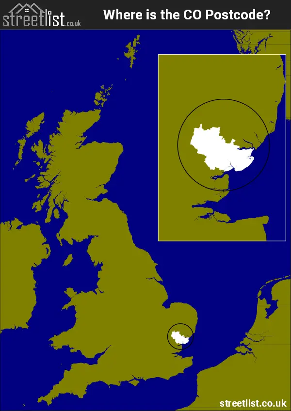
Where is the CO Postcode Area?
The CO Colchester Postcode is in the East of England. The postal area borders the following neighbouring postal areas: CM - Chelmsford, CB - Cambridge and IP - Ipswich, It also borders The North Sea, Hamford Water, Harwich Harbour and The Thames Estuary.
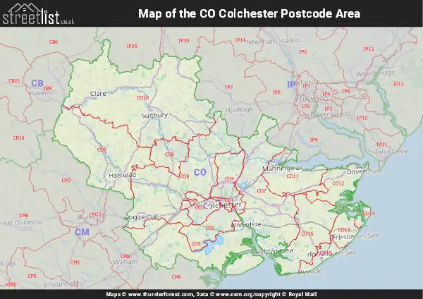
Map of the CO Colchester Postcode Area
Explore the CO Colchester postcode area by using our interactive map.
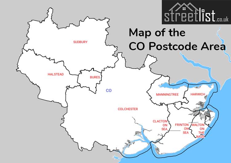
Postcode Districts within the CO Colchester Postcode Area
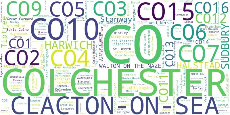
There are 16 postcode districts within the Colchester postcode area
A map showing the boundary of in relation to other areas
There are 13 towns within the Colchester postcode area.
| Unit | Area² |
|---|---|
| Hectares | 1,336,317² |
| Miles | 5,160² |
| Feet | 143,839,825,563² |
| Kilometres | 13,363² |
Postal Delivery Offices serving the CO Colchester Postcode Area
- Alresford (co) Scale Payment Delivery Office
- Ardleigh Scale Payment Delivery Office
- Boxford Scale Payment Delivery Office
- Brightlingsea Delivery Office
- Bures Scale Payment Delivery Office
- Clacton-on-sea Delivery Office
- Coggeshall Scale Payment Delivery Office
- Colchester Delivery Office
- Dedham Scale Payment Delivery Office
- Earls Colne Scale Payment Delivery Office
- East Bergholt Scale Payment Delivery Office
- Eight Ash Green Scale Payment Delivery Office
- Elmstead Scale Payment Delivery Office
- Fingringhoe Scale Payment Delivery Office
- Frinton-on-sea Delivery Office
- Great Bentley Scale Payment Delivery Office
- Great Bromley Scale Payment Delivery Office
- Great Horkesley Scale Payment Delivery Office
- Great Yeldham Scale Payment Delivery Office
- Halstead Delivery Office
- Harwich Delivery Office
- Kelve Delivery Office N Scale Payment Delivery Office
- Lexden Heath Scale Payment Delivery Office
- Manningtree Delivery Office
- Marks Tey Scale Payment Delivery Office
- Nayland Scale Payment Delivery Office
- Polstead Scale Payment Delivery Office
- Rowhedge Scale Payment Delivery Office
- Sible Hedingham Scale Payment Delivery Office
- St. Osyth Scale Payment Delivery Office
- Stoke By Nayland Scale Payment Delivery Office
- Stratford St. Mary Scale Payment Delivery Office
- Sudbury Delivery Office
- Thorrington Scale Payment Delivery Office
- Tiptree Delivery Office
- Wakes Colne Scale Payment Delivery Office
- Walton On The Naze Delivery Office
- West Bergholt Scale Payment Delivery Office
- West Mersea Postal Delivery Office
- Wivenhoe Delivery Office
Councils with Postcodes in CO
Towns and Villages within the CO Colchester Postcode Area
- Abberton - village
- Acton - town
- Aingers Green - village
- Aldham - village
- Alphamstone - village
- Alpheton - village
- Alresford - village
- Ardleigh - village
- Ashen - village
- Assington - village
- Beaumont - village
- Belchamp Otten - village
- Belchamp St Paul - village
- Belchamp Walter - village
- Berechurch - village
- Birch Green - village
- Birdbrook - village
- Boxford - village
- Boxted - village
- Boxted - village
- Boxted Cross - village
- Bradfield - village
- Bradfield Heath - village
- Brantham - village
- Brent Eleigh - village
- Bridge Street - village
- Brightlingsea - town
- Bromley Cross - village
- Bulmer - village
- Bulmer Tye - village
- Bures - village
- Burnt Heath - village
- Calais Street - village
- Castle Hedingham - village
- Cattawade - village
- Cavendish - village
- Chappel - village
- Chilton - otherSettlement
- Clacton-on-Sea - town
- Clare - town
- Coggeshall - town
- Coggeshall Hamlet - village
- Colchester - town
- Colne Engaine - village
- Copford - village
- Crockleford Heath - village
- Cross End - village
- Dedham - village
- Dedham Heath - village
- Earls Colne - village
- East Bergholt - village
- East End - village
- East Mersea - village
- Easthorpe - village
- Eight Ash Green - village
- Elmstead Market - village
- Feering - village
- Fingringhoe - village
- Fordham - village
- Fordstreet - village
- Fox Street - village
- Foxash Estate - village
- Foxearth - village
- Frating - village
- Frating Green - village
- Frinton-on-Sea - town
- Gestingthorpe - village
- Glemsford - village
- Gosfield - village
- Great Bentley - village
- Great Bromley - village
- Great Holland - village
- Great Horkesley - village
- Great Maplestead - village
- Great Oakley - village
- Great Tey - village
- Great Waldingfield - village
- Great Wenham - village
- Great Wigborough - village
- Great Yeldham - village
- Greenstead Green - village
- Groton - village
- Halstead - town
- Harwich - town
- High Park Corner - village
- Higham - village
- Holton St Mary - village
- Hundon - village
- Inworth - village
- Jaywick - village
- Kelvedon - village
- Kirby Cross - village
- Kirkby-le-Soken - village
- Lamarsh - village
- Lamb Corner - village
- Langham - village
- Lavenham - village
- Lawford - village
- Layer Breton - village
- Layer-de-la-Haye - village
- Leavenheath - village
- Little Bentley - village
- Little Bromley - village
- Little Clacton - village
- Little Horkesley - village
- Little Maplestead - village
- Little Oakley - village
- Little Tey - village
- Little Waldingfield - village
- Little Wigborough - village
- Little Yeldham - village
- Long Melford - village
- Malting Green - village
- Manningtree - town
- Marks Tey - village
- Messing - village
- Mill Green - village
- Mistley - village
- Mount Bures - village
- Nayland - village
- Newton - village
- Parkeston - village
- Pebmarsh - village
- Peldon - village
- Pentlow - village
- Point Clear - village
- Polstead - village
- Polstead Heath - village
- Poslingford - village
- Preston St Mary - village
- Ramsey - village
- Ridgewell - village
- Rodbridge Corner - village
- Rose Green - village
- Rowhedge - village
- Seawick - village
- Sible Hedingham - village
- St Osyth - village
- Stanstead - village
- Stoke-by-Clare - village
- Stoke-by-Nayland - village
- Stones Green - village
- Stratford St Mary - village
- Sudbury - town
- Tendring - village
- Tendring Green - village
- Thorpe Green - village
- Thorpe-le-Soken - village
- Thorrington - village
- Tilbury Juxta Clare - village
- Tiptree - village
- Tiptree Heath - village
- Tolleshunt Knights - village
- Toppesfield - village
- Tye Green - village
- Weeley - village
- Weeley Heath - village
- West Bergholt - village
- West Mersea - town
- White Colne - village
- Whitestreet Green - village
- Wickham St Paul - village
- Wivenhoe - town
- Wix - village
- Wix Green - village
- Wixoe - village
- Workhouse Green - village
- Workhouse Hill - village
- Wormingford - village
- Wrabness - village