The CO4 postcode district is a postal district located in the CO Colchester postcode area with a population of 53,273 residents according to the 2021 England and Wales Census.
The area of the CO4 postcode district is 17.00 square miles which is 44.04 square kilometres or 10,881.74 acres.
Currently, the CO4 district has about 1151 postcode units spread across 4 geographic postcode sectors.
Given that each sector allows for 400 unique postcode combinations, the district has a capacity of 1,600 postcodes. With 1151 postcodes already in use, this leaves 449 units available.
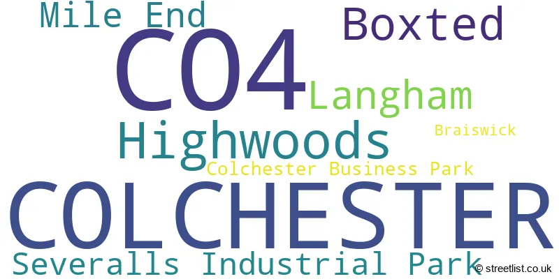
The largest settlement in the CO4 postal code is COLCHESTER followed by Highwoods, and Boxted.
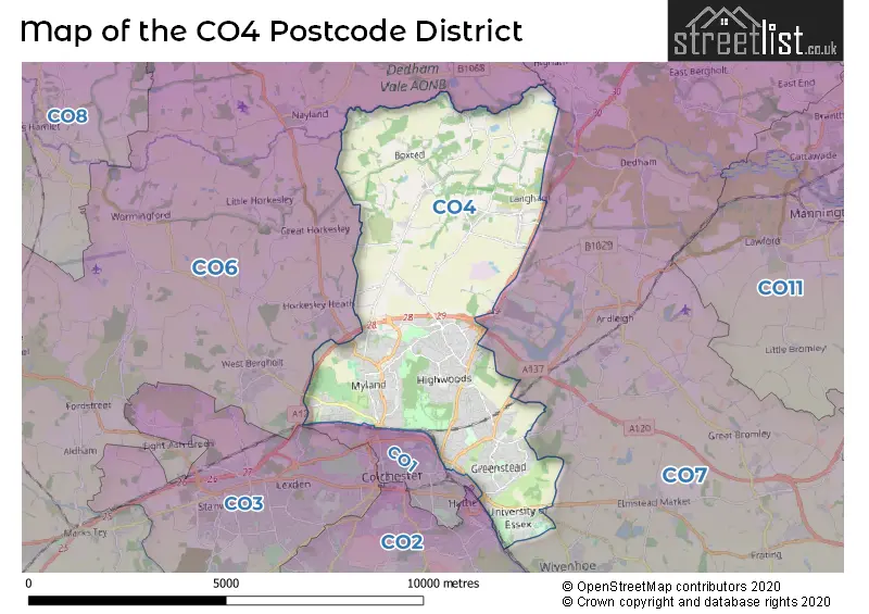
The CO4 Postcode shares a border with CO1 (COLCHESTER), CO6 (Coggeshall, Earls Colne, West Bergholt) and CO7 (Brightlingsea, Wivenhoe, Great Bentley).
The primary settlement in the CO4 postcode district is Colchester, a town in the county of Essex in England. Other significant settlements in the district include Boxted, Braiswick, Langham, and Mile End. The most significant post town in the district is also Colchester.
For the district CO4, we have data on 5 postcode sectors. Here's a breakdown: The sector CO4 0, covers Colchester in Essex. The sector CO4 3, covers Colchester in Essex. The sector CO4 5, covers Colchester and Boxted and Langham and Mile End in Essex. The sector CO4 6 is non-geographic. It's often designated for PO Boxes, large organisations, or special services. The sector CO4 9, covers Highwoods and Colchester and Severalls Industrial Park in Essex.

Map of the CO4 Postcode District
Explore the CO4 postcode district by using our free interactive map.
When it comes to local government, postal geography often disregards political borders. However, for a breakdown in the CO4 District: the district mostly encompasses the Colchester District (B) (1163 postcodes), and finally, the Tendring District area (17 postcodes).
Weather Forecast for CO4
Press Button to Show Forecast for Colchester United F.C.
| Time Period | Icon | Description | Temperature | Rain Probability | Wind |
|---|---|---|---|---|---|
| 00:00 to 03:00 | Overcast | 6.0°C (feels like 4.0°C) | 16.00% | NE 7 mph | |
| 03:00 to 06:00 | Heavy rain | 6.0°C (feels like 4.0°C) | 83.00% | NE 7 mph | |
| 06:00 to 09:00 | Heavy rain | 6.0°C (feels like 3.0°C) | 81.00% | NE 9 mph | |
| 09:00 to 12:00 | Light rain | 8.0°C (feels like 5.0°C) | 49.00% | NE 11 mph | |
| 12:00 to 15:00 | Cloudy | 11.0°C (feels like 9.0°C) | 53.00% | ENE 9 mph | |
| 15:00 to 18:00 | Cloudy | 12.0°C (feels like 10.0°C) | 8.00% | ENE 9 mph | |
| 18:00 to 21:00 | Cloudy | 11.0°C (feels like 8.0°C) | 15.00% | ENE 9 mph | |
| 21:00 to 00:00 | Heavy rain | 9.0°C (feels like 6.0°C) | 85.00% | NE 11 mph |
Press Button to Show Forecast for Colchester United F.C.
| Time Period | Icon | Description | Temperature | Rain Probability | Wind |
|---|---|---|---|---|---|
| 00:00 to 03:00 | Heavy rain | 9.0°C (feels like 6.0°C) | 91.00% | NE 11 mph | |
| 03:00 to 06:00 | Heavy rain | 9.0°C (feels like 7.0°C) | 86.00% | ENE 9 mph | |
| 06:00 to 09:00 | Heavy rain | 10.0°C (feels like 7.0°C) | 82.00% | WSW 11 mph | |
| 09:00 to 12:00 | Heavy rain shower (day) | 10.0°C (feels like 8.0°C) | 63.00% | WNW 13 mph | |
| 12:00 to 15:00 | Heavy rain shower (day) | 11.0°C (feels like 8.0°C) | 62.00% | WSW 16 mph | |
| 15:00 to 18:00 | Light rain shower (day) | 10.0°C (feels like 7.0°C) | 41.00% | W 13 mph | |
| 18:00 to 21:00 | Cloudy | 10.0°C (feels like 8.0°C) | 11.00% | WSW 9 mph | |
| 21:00 to 00:00 | Partly cloudy (night) | 8.0°C (feels like 6.0°C) | 3.00% | SW 9 mph |
Press Button to Show Forecast for Colchester United F.C.
| Time Period | Icon | Description | Temperature | Rain Probability | Wind |
|---|---|---|---|---|---|
| 00:00 to 03:00 | Clear night | 7.0°C (feels like 5.0°C) | 2.00% | SW 7 mph | |
| 03:00 to 06:00 | Clear night | 6.0°C (feels like 3.0°C) | 2.00% | SSW 7 mph | |
| 06:00 to 09:00 | Sunny day | 7.0°C (feels like 5.0°C) | 1.00% | SSW 7 mph | |
| 09:00 to 12:00 | Sunny day | 11.0°C (feels like 9.0°C) | 1.00% | S 9 mph | |
| 12:00 to 15:00 | Partly cloudy (day) | 13.0°C (feels like 11.0°C) | 2.00% | SSE 11 mph | |
| 15:00 to 18:00 | Partly cloudy (day) | 14.0°C (feels like 11.0°C) | 2.00% | SSE 11 mph | |
| 18:00 to 21:00 | Sunny day | 12.0°C (feels like 10.0°C) | 1.00% | SE 9 mph | |
| 21:00 to 00:00 | Clear night | 9.0°C (feels like 7.0°C) | 2.00% | SE 9 mph |
Press Button to Show Forecast for Colchester United F.C.
| Time Period | Icon | Description | Temperature | Rain Probability | Wind |
|---|---|---|---|---|---|
| 00:00 to 03:00 | Partly cloudy (night) | 9.0°C (feels like 7.0°C) | 3.00% | SE 7 mph | |
| 03:00 to 06:00 | Clear night | 8.0°C (feels like 6.0°C) | 4.00% | ESE 7 mph | |
| 06:00 to 09:00 | Overcast | 10.0°C (feels like 8.0°C) | 10.00% | ESE 9 mph | |
| 09:00 to 12:00 | Cloudy | 13.0°C (feels like 11.0°C) | 9.00% | SE 9 mph | |
| 12:00 to 15:00 | Cloudy | 14.0°C (feels like 12.0°C) | 6.00% | SE 9 mph | |
| 15:00 to 18:00 | Cloudy | 15.0°C (feels like 13.0°C) | 7.00% | ESE 9 mph | |
| 18:00 to 21:00 | Cloudy | 13.0°C (feels like 12.0°C) | 8.00% | ESE 9 mph | |
| 21:00 to 00:00 | Cloudy | 12.0°C (feels like 10.0°C) | 19.00% | E 9 mph |
Where is the CO4 Postcode District?
The postcode district CO4 is located in the town of Colchester. It is in close proximity to several nearby towns, including Bures (7.07 miles to the north-west), Manningtree (7.50 miles to the east), Clacton-on-Sea (12.31 miles to the south-east), Ipswich (13.02 miles to the north-east), Halstead (13.20 miles to the west), and Witham (14.80 miles to the south-west). Additionally, the distance to the centre of London is approximately 53.71 miles.
The district is within the post town of COLCHESTER.
The sector has postcodes within the nation of England.
The CO4 Postcode District is in the Essex Haven Gateway region of Essex within the East of England.
| Postcode Sector | Delivery Office |
|---|---|
| CO4 0 | Colchester Delivery Office |
| CO4 3 | Colchester Delivery Office |
| CO4 5 | Colchester Delivery Office |
| CO4 9 | Colchester Delivery Office |
| C | O | 4 | - | X | X | X |
| C | O | 4 | Space | Numeric | Letter | Letter |
Current Monthly Rental Prices
| # Bedrooms | Min Price | Max Price | Avg Price |
|---|---|---|---|
| 4 | £3,000 | £3,000 | £3,000 |
| 5 | £2,200 | £2,800 | £2,390 |
| 6 | £2,250 | £2,800 | £2,514 |
Current House Prices
| # Bedrooms | Min Price | Max Price | Avg Price |
|---|---|---|---|
| £1,500,000 | £1,500,000 | £1,500,000 | |
| 3 | £1,000,000 | £1,000,000 | £1,000,000 |
| 4 | £675,000 | £1,000,000 | £828,846 |
| 5 | £675,000 | £1,700,000 | £957,500 |
| 6 | £1,050,000 | £2,400,000 | £1,725,000 |
Estate Agents who Operate in the CO4 District
| Logo | Name | Brand Name | Address | Contact Number | Total Properties |
|---|---|---|---|---|---|
 | Colchester St Johns | William H. Brown | 42a St. Christopher Road Colchester CO4 0NA | 01206 586062 | 31 |
 | Colchester | Palmer & Partners | 43 Crouch Street Colchester CO3 3EN | 01206 586084 | 28 |
 | Colchester | Fenn Wright | 146 High Street, Colchester, CO1 1PW | 01206 586120 | 25 |
 | Chesterwell | Harris + Wood | Unit 10 Chesterwell House Cordelia Drive, Colchester, CO4 6AZ | 01206 636476 | 19 |
 | Colchester | haart | 18-20 Head Street Colchester CO1 1NY | 01206 586147 | 18 |
| Type of Property | 2018 Average | 2018 Sales | 2017 Average | 2017 Sales | 2016 Average | 2016 Sales | 2015 Average | 2015 Sales |
|---|---|---|---|---|---|---|---|---|
| Detached | £381,614 | 346 | £382,950 | 314 | £361,539 | 272 | £334,100 | 228 |
| Semi-Detached | £281,923 | 301 | £262,441 | 243 | £248,472 | 234 | £210,496 | 215 |
| Terraced | £241,411 | 257 | £237,665 | 264 | £225,763 | 314 | £201,434 | 337 |
| Flats | £169,861 | 203 | £149,328 | 195 | £134,400 | 240 | £122,256 | 224 |