The CO6 postcode district is a postal district located in the CO Colchester postcode area with a population of 28,977 residents according to the 2021 England and Wales Census.
The area of the CO6 postcode district is 70.72 square miles which is 183.15 square kilometres or 45,258.06 acres.
Currently, the CO6 district has about 1005 postcode units spread across 5 geographic postcode sectors.
Given that each sector allows for 400 unique postcode combinations, the district has a capacity of 2,000 postcodes. With 1005 postcodes already in use, this leaves 995 units available.
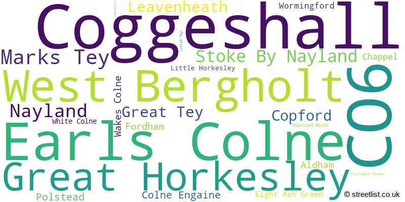
The largest settlement in the CO6 postal code is Coggeshall followed by Earls Colne, and West Bergholt.
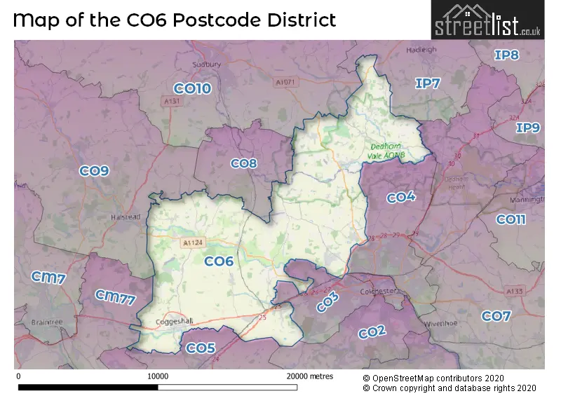
The CO6 Postcode shares a border with IP7 (Hadleigh, Elmsett, Bildeston), CO10 (SUDBURY, Great Cornard, Long Melford), CO8 (BURES, Mount Bures, Alphamstone), CM77 (Great Notley, Rayne, Cressing), CO2 (COLCHESTER, Layer-de-la-Haye, Birch), CO3 (COLCHESTER, Stanway, Fordham Heath), CO4 (COLCHESTER, Highwoods, Boxted), CO9 (HALSTEAD, Sible Hedingham, Great Yeldham), CO5 (Tiptree, West Mersea, Kelvedon) and CO7 (Brightlingsea, Wivenhoe, Great Bentley).
In the CO6 postcode district, the primary settlement is Coggeshall, located in the county of Essex, England. Other significant settlements within this district include Copford, Great Tey, Marks Tey, and Colne Engaine. The most significant post town in this district is Colchester.
For the district CO6, we have data on 5 postcode sectors. Here's a breakdown: The sector CO6 1, covers Coggeshall and Marks Tey and Great Tey and Copford in Essex. The sector CO6 2, covers Earls Colne and Colne Engaine and Wakes Colne and Chappel in Essex. The sector CO6 3, covers West Bergholt and Fordham and Aldham and Wormingford in Essex. The sector CO6 4, covers Great Horkesley in Essex. The sector CO6 4, covers Nayland and Stoke By Nayland and Leavenheath in Suffolk. The sector CO6 5, covers Polstead and Polstead Heath in Suffolk.

Map of the CO6 Postcode District
Explore the CO6 postcode district by using our free interactive map.
When it comes to local government, postal geography often disregards political borders. However, for a breakdown in the CO6 District: the district mostly encompasses the Colchester District (B) (540 postcodes), followed by the Braintree District area (277 postcodes), and finally, the Babergh District area (197 postcodes).
Weather Forecast for CO6
Press Button to Show Forecast for Colchester United F.C.
| Time Period | Icon | Description | Temperature | Rain Probability | Wind |
|---|---|---|---|---|---|
| 12:00 to 15:00 | Cloudy | 11.0°C (feels like 9.0°C) | 53.00% | ENE 9 mph | |
| 15:00 to 18:00 | Cloudy | 12.0°C (feels like 10.0°C) | 8.00% | ENE 9 mph | |
| 18:00 to 21:00 | Cloudy | 11.0°C (feels like 8.0°C) | 15.00% | ENE 9 mph | |
| 21:00 to 00:00 | Heavy rain | 9.0°C (feels like 6.0°C) | 85.00% | NE 11 mph |
Press Button to Show Forecast for Colchester United F.C.
| Time Period | Icon | Description | Temperature | Rain Probability | Wind |
|---|---|---|---|---|---|
| 00:00 to 03:00 | Heavy rain | 9.0°C (feels like 6.0°C) | 91.00% | NE 11 mph | |
| 03:00 to 06:00 | Heavy rain | 9.0°C (feels like 7.0°C) | 86.00% | ENE 9 mph | |
| 06:00 to 09:00 | Heavy rain | 10.0°C (feels like 7.0°C) | 82.00% | WSW 11 mph | |
| 09:00 to 12:00 | Heavy rain shower (day) | 10.0°C (feels like 8.0°C) | 63.00% | WNW 13 mph | |
| 12:00 to 15:00 | Heavy rain shower (day) | 11.0°C (feels like 8.0°C) | 62.00% | WSW 16 mph | |
| 15:00 to 18:00 | Light rain shower (day) | 10.0°C (feels like 7.0°C) | 41.00% | W 13 mph | |
| 18:00 to 21:00 | Cloudy | 10.0°C (feels like 8.0°C) | 11.00% | WSW 9 mph | |
| 21:00 to 00:00 | Partly cloudy (night) | 8.0°C (feels like 6.0°C) | 3.00% | SW 9 mph |
Press Button to Show Forecast for Colchester United F.C.
| Time Period | Icon | Description | Temperature | Rain Probability | Wind |
|---|---|---|---|---|---|
| 00:00 to 03:00 | Clear night | 7.0°C (feels like 5.0°C) | 2.00% | SW 7 mph | |
| 03:00 to 06:00 | Clear night | 6.0°C (feels like 3.0°C) | 2.00% | SSW 7 mph | |
| 06:00 to 09:00 | Sunny day | 7.0°C (feels like 5.0°C) | 1.00% | SSW 7 mph | |
| 09:00 to 12:00 | Sunny day | 11.0°C (feels like 9.0°C) | 1.00% | S 9 mph | |
| 12:00 to 15:00 | Partly cloudy (day) | 13.0°C (feels like 11.0°C) | 2.00% | SSE 11 mph | |
| 15:00 to 18:00 | Partly cloudy (day) | 14.0°C (feels like 11.0°C) | 2.00% | SSE 11 mph | |
| 18:00 to 21:00 | Sunny day | 12.0°C (feels like 10.0°C) | 1.00% | SE 9 mph | |
| 21:00 to 00:00 | Clear night | 9.0°C (feels like 7.0°C) | 2.00% | SE 9 mph |
Press Button to Show Forecast for Colchester United F.C.
| Time Period | Icon | Description | Temperature | Rain Probability | Wind |
|---|---|---|---|---|---|
| 00:00 to 03:00 | Partly cloudy (night) | 9.0°C (feels like 7.0°C) | 3.00% | SE 7 mph | |
| 03:00 to 06:00 | Clear night | 8.0°C (feels like 6.0°C) | 4.00% | ESE 7 mph | |
| 06:00 to 09:00 | Overcast | 10.0°C (feels like 8.0°C) | 10.00% | ESE 9 mph | |
| 09:00 to 12:00 | Cloudy | 13.0°C (feels like 11.0°C) | 9.00% | SE 9 mph | |
| 12:00 to 15:00 | Cloudy | 14.0°C (feels like 12.0°C) | 6.00% | SE 9 mph | |
| 15:00 to 18:00 | Cloudy | 15.0°C (feels like 13.0°C) | 7.00% | ESE 9 mph | |
| 18:00 to 21:00 | Cloudy | 13.0°C (feels like 12.0°C) | 8.00% | ESE 9 mph | |
| 21:00 to 00:00 | Cloudy | 12.0°C (feels like 10.0°C) | 19.00% | E 9 mph |
Where is the CO6 Postcode District?
The data shows that the postcode district CO6 is located in the town of Colchester. This district is surrounded by several nearby towns including Bures to the North, Halstead to the West, Witham to the South West, Manningtree to the East, Maldon to the South, Clacton-on-Sea to the South East, and Ipswich to the North East. Additionally, the distance from the CO6 district to the center of London is approximately 49.21 miles.
The district is within the post town of COLCHESTER.
The sector has postcodes within the nation of England.
The CO6 Postcode District is covers the following regions.
- Essex Haven Gateway - Essex - East of England
- Suffolk - East Anglia - East of England
| Postcode Sector | Delivery Office |
|---|---|
| CO6 1 | Coggeshall Scale Payment Delivery Office |
| CO6 1 | Marks Tey Scale Payment Delivery Office |
| CO6 2 | Earls Colne Scale Payment Delivery Office |
| CO6 2 | Wakes Colne Scale Payment Delivery Office |
| CO6 3 | West Bergholt Scale Payment Delivery Office |
| CO6 3 | Eight Ash Green Scale Payment Delivery Office |
| CO6 3 | Bures Scale Payment Delivery Office |
| CO6 4 | Great Horkesley Scale Payment Delivery Office |
| CO6 4 | Nayland Scale Payment Delivery Office |
| CO6 4 | Stoke By Nayland Scale Payment Delivery Office |
| CO6 5 | Polstead Scale Payment Delivery Office |
| C | O | 6 | - | X | X | X |
| C | O | 6 | Space | Numeric | Letter | Letter |
Tourist Attractions within the Postcode Area
We found 2 visitor attractions within the CO6 postcode area
| Paycocke's House and Garden |
|---|
| Historic Properties |
| Historic House / House and Garden / Palace |
| View Paycocke's House and Garden on Google Maps |
| Coggeshall Grange Barn |
| Historic Properties |
| Other Historic Property |
| View Coggeshall Grange Barn on Google Maps |
Current Monthly Rental Prices
| # Bedrooms | Min Price | Max Price | Avg Price |
|---|---|---|---|
| £150 | £1,700 | £925 | |
| 1 | £735 | £900 | £818 |
| 2 | £900 | £950 | £925 |
| 3 | £900 | £1,900 | £1,441 |
| 4 | £1,700 | £2,500 | £2,140 |
| 5 | £2,800 | £3,250 | £3,025 |
Current House Prices
| # Bedrooms | Min Price | Max Price | Avg Price |
|---|---|---|---|
| 4 | £1,100,000 | £1,500,000 | £1,280,000 |
| 5 | £1,100,000 | £1,950,000 | £1,363,000 |
| 6 | £1,150,000 | £2,500,000 | £2,016,667 |
| 7 | £1,150,000 | £1,150,000 | £1,150,000 |
| 9 | £6,250,000 | £6,250,000 | £6,250,000 |
Estate Agents who Operate in the CO6 District
| Logo | Name | Brand Name | Address | Contact Number | Total Properties |
|---|---|---|---|---|---|
 | Coggeshall | Heritage | 3B Manchester House, Church Street, Coggeshall, Essex, CO6 1TU | 01376 315146 | 28 |
 | Stanway | Fenn Wright | 1 Tollgate East, Stanway, Colchester, CO3 8RQ | 01206 586109 | 24 |
 | Earls Colne | Percival & Company | High Street, Earls Colne, CO6 2RN | 01787 322358 | 20 |
 | Leavenheath | David Burr Estate Agents | Parkers Lodge, Honey Tye, Leavenheath, CO6 4NX | 01206 586066 | 19 |
 | Colchester | Michaels Property Consultants Ltd | Rebow House 62 Head Street Colchester CO1 1PB | 01206 586143 | 18 |
- Aldham
- Bell's Corner
- Broad Green
- Calais Street
- Chappel
- Coggeshall
- Coggeshall Hamlet
- Colchester
- Colne Engaine
- Copford
- Countess Cross
- Earls Colne
- Eight Ash Green
- Fordham
- Fordstreet
- Gallows Green
- Great Horkesley
- Great Tey
- Halstead
- Higham
- Honey Tye
- Leavenheath
- Little Horkesley
- Little Tey
- Marks Tey
- Mill Street
- Mount Bures
- Mulberry Green
- Nayland
- Pattiswick
- Polstead
- Polstead Heath
- Rose Green
- Scotland Street
- Shelley
- Stoke-by-Nayland
- Surrex
- Swan Street
- Thorington Street
- Tye Green
- Wakes Colne
- West Bergholt
- White Colne
- Whitestreet Green
- William's Green
- Wissington
- Wormingford
| Type of Property | 2018 Average | 2018 Sales | 2017 Average | 2017 Sales | 2016 Average | 2016 Sales | 2015 Average | 2015 Sales |
|---|---|---|---|---|---|---|---|---|
| Detached | £461,659 | 190 | £468,340 | 225 | £469,696 | 230 | £444,714 | 252 |
| Semi-Detached | £304,879 | 111 | £317,333 | 123 | £304,040 | 131 | £270,275 | 141 |
| Terraced | £275,497 | 85 | £252,269 | 66 | £247,489 | 71 | £264,153 | 83 |
| Flats | £156,972 | 46 | £162,566 | 42 | £144,163 | 58 | £134,203 | 43 |