The CO8 postcode district is a postal district located in the CO Colchester postcode area with a population of 2,406 residents according to the 2021 England and Wales Census.
The area of the CO8 postcode district is 12.54 square miles which is 32.48 square kilometres or 8,025.28 acres.
Currently, the CO8 district has about 123 postcode units spread across 1 geographic postcode sectors.
Given that each sector allows for 400 unique postcode combinations, the district has a capacity of 400 postcodes. With 123 postcodes already in use, this leaves 277 units available.
The largest settlement in the CO8 postal code is BURES followed by Mount Bures, and Alphamstone.
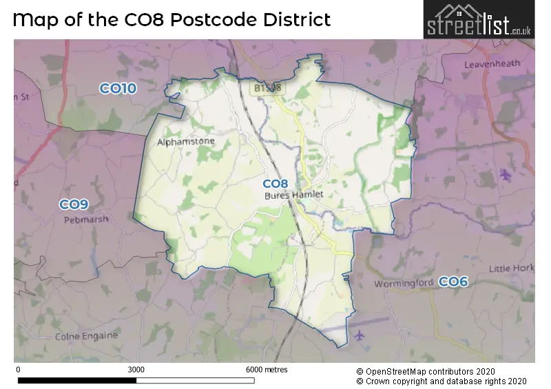
The CO8 Postcode shares a border with CO10 (SUDBURY, Great Cornard, Long Melford), CO6 (Coggeshall, Earls Colne, West Bergholt) and CO9 (HALSTEAD, Sible Hedingham, Great Yeldham).
In the CO8 postcode district, the primary settlement is Bures, which is located in the county of Essex. Other significant settlements in the district include Alphamstone, Lamarsh, and Mount Bures, all located in Essex as well. The most significant post town in the district is Bures.
For the district CO8, we have data on 1 postcode sectors. Here's a breakdown: The sector CO8 5, covers Bures in Suffolk. The sector CO8 5, covers Bures and Mount Bures and Alphamstone in Essex.
CO8 Postcode Sectors

Map of the CO8 Postcode District
Explore the CO8 postcode district by using our free interactive map.
When it comes to local government, postal geography often disregards political borders. However, for a breakdown in the CO8 District: the district mostly encompasses the Braintree District (60 postcodes), followed by the Babergh District area (49 postcodes), and finally, the Colchester District (B) area (15 postcodes).
Weather Forecast for CO8
Press Button to Show Forecast for Sudbury
| Time Period | Icon | Description | Temperature | Rain Probability | Wind |
|---|---|---|---|---|---|
| 06:00 to 09:00 | Heavy rain | 6.0°C (feels like 4.0°C) | 82.00% | NE 9 mph | |
| 09:00 to 12:00 | Light rain | 8.0°C (feels like 5.0°C) | 58.00% | NE 11 mph | |
| 12:00 to 15:00 | Cloudy | 10.0°C (feels like 8.0°C) | 17.00% | ENE 9 mph | |
| 15:00 to 18:00 | Cloudy | 11.0°C (feels like 10.0°C) | 51.00% | NE 9 mph | |
| 18:00 to 21:00 | Cloudy | 11.0°C (feels like 9.0°C) | 12.00% | NE 9 mph | |
| 21:00 to 00:00 | Heavy rain | 9.0°C (feels like 6.0°C) | 82.00% | NE 11 mph |
Press Button to Show Forecast for Sudbury
| Time Period | Icon | Description | Temperature | Rain Probability | Wind |
|---|---|---|---|---|---|
| 00:00 to 03:00 | Heavy rain | 9.0°C (feels like 6.0°C) | 88.00% | NNE 11 mph | |
| 03:00 to 06:00 | Heavy rain | 9.0°C (feels like 7.0°C) | 90.00% | NE 9 mph | |
| 06:00 to 09:00 | Heavy rain | 9.0°C (feels like 7.0°C) | 86.00% | WNW 9 mph | |
| 09:00 to 12:00 | Heavy rain | 10.0°C (feels like 8.0°C) | 78.00% | W 11 mph | |
| 12:00 to 15:00 | Heavy rain shower (day) | 11.0°C (feels like 8.0°C) | 61.00% | W 13 mph | |
| 15:00 to 18:00 | Light rain | 10.0°C (feels like 7.0°C) | 52.00% | W 13 mph | |
| 18:00 to 21:00 | Cloudy | 10.0°C (feels like 8.0°C) | 13.00% | WSW 9 mph | |
| 21:00 to 00:00 | Partly cloudy (night) | 8.0°C (feels like 5.0°C) | 4.00% | SW 7 mph |
Press Button to Show Forecast for Sudbury
| Time Period | Icon | Description | Temperature | Rain Probability | Wind |
|---|---|---|---|---|---|
| 00:00 to 03:00 | Partly cloudy (night) | 7.0°C (feels like 4.0°C) | 2.00% | SW 7 mph | |
| 03:00 to 06:00 | Clear night | 5.0°C (feels like 3.0°C) | 2.00% | SSW 7 mph | |
| 06:00 to 09:00 | Sunny day | 6.0°C (feels like 4.0°C) | 1.00% | S 7 mph | |
| 09:00 to 12:00 | Partly cloudy (day) | 12.0°C (feels like 10.0°C) | 1.00% | SSW 9 mph | |
| 12:00 to 15:00 | Cloudy | 14.0°C (feels like 11.0°C) | 5.00% | S 11 mph | |
| 15:00 to 18:00 | Cloudy | 14.0°C (feels like 12.0°C) | 5.00% | SSE 11 mph | |
| 18:00 to 21:00 | Sunny day | 13.0°C (feels like 11.0°C) | 1.00% | SSE 9 mph | |
| 21:00 to 00:00 | Clear night | 9.0°C (feels like 7.0°C) | 2.00% | SE 7 mph |
Press Button to Show Forecast for Sudbury
| Time Period | Icon | Description | Temperature | Rain Probability | Wind |
|---|---|---|---|---|---|
| 00:00 to 03:00 | Clear night | 8.0°C (feels like 6.0°C) | 2.00% | SE 7 mph | |
| 03:00 to 06:00 | Partly cloudy (night) | 8.0°C (feels like 6.0°C) | 5.00% | ESE 7 mph | |
| 06:00 to 09:00 | Cloudy | 9.0°C (feels like 8.0°C) | 8.00% | ESE 7 mph | |
| 09:00 to 12:00 | Cloudy | 13.0°C (feels like 12.0°C) | 8.00% | ESE 9 mph | |
| 12:00 to 15:00 | Cloudy | 15.0°C (feels like 13.0°C) | 12.00% | SE 9 mph | |
| 15:00 to 18:00 | Partly cloudy (day) | 16.0°C (feels like 14.0°C) | 7.00% | SE 11 mph | |
| 18:00 to 21:00 | Cloudy | 14.0°C (feels like 13.0°C) | 8.00% | ESE 9 mph | |
| 21:00 to 00:00 | Light rain shower (night) | 12.0°C (feels like 10.0°C) | 43.00% | E 7 mph |
Where is the CO8 Postcode District?
The postcode district CO8 is located in the town of Bures. Bures is surrounded by several nearby towns such as Sudbury to the North, Halstead to the South West, Colchester to the South East, Manningtree to the East, Haverhill to the North West, and Maldon to the South. The distance from CO8 to the centre of London is approximately 50.1 miles.
The district is within the post town of BURES.
The sector has postcodes within the nation of England.
The CO8 Postcode District is covers the following regions.
- Suffolk - East Anglia - East of England
- Essex Haven Gateway - Essex - East of England
Postcode Sectors within the CO8 District
| Postcode Sector | Delivery Office |
|---|---|
| CO8 5 | Bures Scale Payment Delivery Office |
| C | O | 8 | - | X | X | X |
| C | O | 8 | Space | Numeric | Letter | Letter |
Current Monthly Rental Prices
| # Bedrooms | Min Price | Max Price | Avg Price |
|---|
Current House Prices
| # Bedrooms | Min Price | Max Price | Avg Price |
|---|---|---|---|
| £40,000 | £275,000 | £105,000 | |
| 2 | £165,000 | £595,000 | £380,000 |
| 3 | £365,000 | £675,000 | £495,000 |
| 4 | £350,000 | £1,150,000 | £711,000 |
| 5 | £700,000 | £1,000,000 | £850,000 |
| 6 | £1,600,000 | £1,600,000 | £1,600,000 |
Estate Agents who Operate in the CO8 District
| Logo | Name | Brand Name | Address | Contact Number | Total Properties |
|---|---|---|---|---|---|
 | Colchester | Nicholas Percival | Beacon End Farmhouse London Road, Stanway, CO3 0NQ | 01206 586122 | 4 |
 | Leavenheath | David Burr Estate Agents | Parkers Lodge, Honey Tye, Leavenheath, CO6 4NX | 01206 586066 | 3 |
 | Hammersmith Auctions | Barnard Marcus | Sovereign House, 361 King Street Hammersmith London W6 9NA | 020 3866 9305 | 3 |
 | London | Barney Estates and Auctioneers | Baltimore House, Juniper Drive, London, SW18 1TS | 020 8432 7330 | 2 |
 | Sudbury | Bychoice | 6 King Street, Sudbury, CO10 2EB | 01787 322232 | 2 |
| Type of Property | 2018 Average | 2018 Sales | 2017 Average | 2017 Sales | 2016 Average | 2016 Sales | 2015 Average | 2015 Sales |
|---|---|---|---|---|---|---|---|---|
| Detached | £521,885 | 26 | £612,167 | 18 | £455,774 | 19 | £415,133 | 15 |
| Semi-Detached | £268,800 | 10 | £323,556 | 9 | £313,136 | 11 | £248,400 | 5 |
| Terraced | £173,100 | 5 | £252,500 | 2 | £228,500 | 8 | £199,450 | 10 |
| Flats | £440,000 | 2 | £0 | 0 | £189,500 | 1 | £153,250 | 1 |