This section of the site is all about the IP Postcode area, also known as the Ipswich Postal Area. Explore links to the next level to learn more about specific postcode districts such as IP1.
The IP postcode area represents a group of postal districts in the Ipswich area of the United Kingdom. The area code IP stands for the letters i and p in IPswich. IP has a population of 595,934 and covers an area of 3,787,798 hectares. Fun fact: 0.92% of the population of Great Britain lives in this area.
The postcode area falls within the following counties: Suffolk (87.11%), Norfolk (12.89%), Cambridgeshire (0.00%).
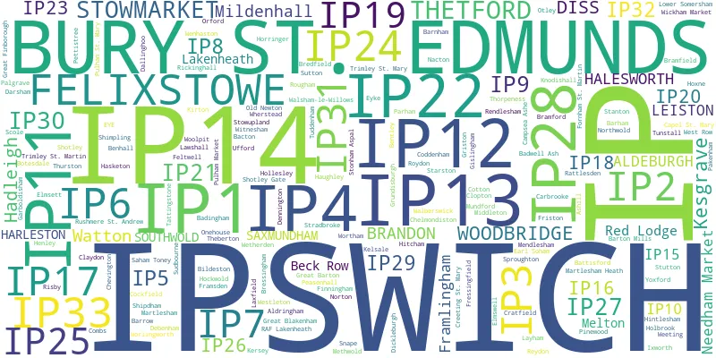
Post Towns and Postcode Districts for the IP Postcode
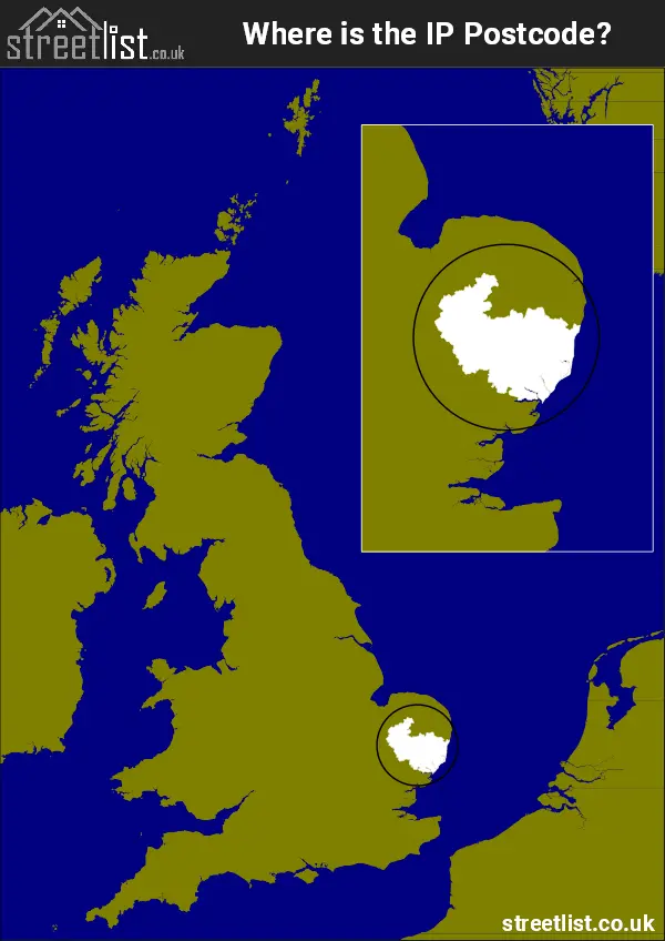
Where is the IP Postcode Area?
The IP Ipswich Postcode is in the East of England. The postal area borders the following neighbouring postal areas: PE - Peterborough, CO - Colchester, CB - Cambridge and NR - Norwich, It also borders The North Sea and Harwich Harbour.
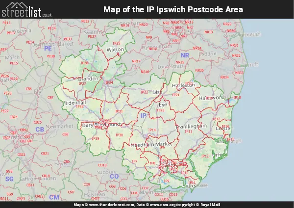
Map of the IP Ipswich Postcode Area
Explore the IP Ipswich postcode area by using our interactive map.
Postcode Districts within the IP Ipswich Postcode Area
There are 33 postcode districts within the Ipswich postcode area
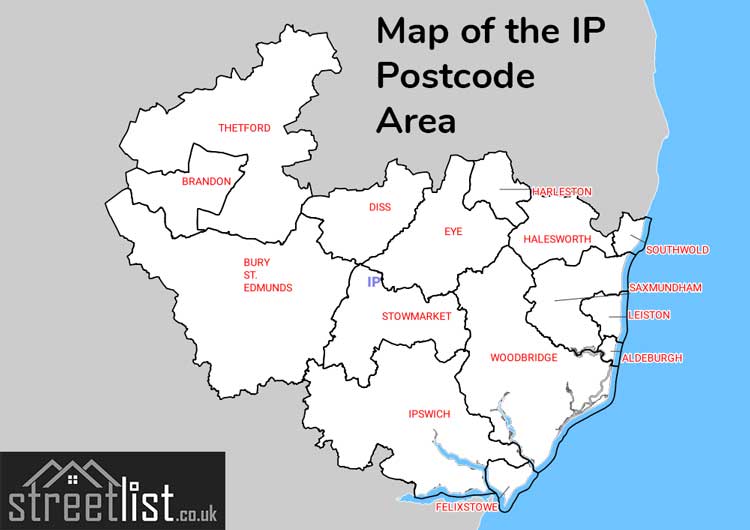
A map showing the boundary of in relation to other areas
There are 22 towns within the Ipswich postcode area.
| Unit | Area² |
|---|---|
| Hectares | 3,787,798² |
| Miles | 14,625² |
| Feet | 407,714,788,922² |
| Kilometres | 37,878² |
Postal Delivery Offices serving the IP Ipswich Postcode Area
- Bardwell Scale Payment Delivery Office
- Barningham Scale Payment Delivery Office
- Bedfield Scale Payment Delivery Office
- Brandon Delivery Office
- Bury St. Edmunds Delivery Office
- Capel St Mary Scale Payment Delivery Office
- Coddenham Scale Payment Delivery Office
- Diss Delivery Office
- Elmswell Scale Payment Delivery Office
- Felixstowe Delivery Office
- Feltwell Scale Payment Delivery Office
- Framlingham Scale Payment Delivery Office
- Great Barton Scale Payment Delivery Office
- Grundisburgh Scale Payment Delivery Office
- Hadleigh Delivery Office
- Halesworth Delivery Office
- Harleston Scale Payment Delivery Office
- Higham Scale Payment Delivery Office
- Honington Scale Payment Delivery Office
- Ipswich Delivery Office
- Ipswich East Delivery Office
- Ixworth Scale Payment Delivery Office
- Kesgrave Scale Payment Delivery Office
- Lakenheath Scale Payment Delivery Office
- Leiston Delivery Office
- Mildenhall Delivery Office
- Mundford Scale Payment Delivery Office
- Nacton Scale Payment Delivery Office
- Needham Market Scale Payment Delivery Office
- Peasenhall Scale Payment Delivery Office
- Saham Toney Scale Payment Delivery Office
- Saxmundham Delivery Office
- Shipdham Scale Payment Delivery Office
- Southwold Delivery Office
- Stanton Scale Payment Delivery Office
- Stowmarket Delivery Office
- Thetford Delivery Office
- Thurston Scale Payment Delivery Office
- Watton Scale Payment Delivery Office
- West Row Scale Payment Delivery Office
- Whepstead Scale Payment Delivery Office
- Wickham Market Scale Payment Delivery Office
- Witnesham Scale Payment Delivery Office
- Woodbridge Delivery Office
- Woolpit Scale Payment Delivery Office
Councils with Postcodes in IP
Towns and Villages within the IP Ipswich Postcode Area
- Alburgh - village
- Alburgh Street - village
- Aldeburgh - town
- Alderton - village
- Aldham - village
- Aldringham - village
- All Saints' South Elmham - village
- Ashbocking - village
- Ashfield Cum Thorpe - village
- Ashill - village
- Bacton - village
- Badingham - village
- Badwell Ash - village
- Bardwell - village
- Barham - village
- Barking - village
- Barking Tye - village
- Barnham - village
- Barningham - village
- Barrow - village
- Barton Mills - village
- Battisford - village
- Battisford Tye - village
- Bawdsey - village
- Baylham - village
- Beck Row - village
- Bedfield - village
- Bedfield Long Green - village
- Belstead - village
- Benhall Green - village
- Bentley - village
- Beyton - village
- Bildeston - village
- Blackheath - village
- Blaxhall - village
- Blo' Norton - village
- Blythburgh - village
- Boot Street - village
- Borley Green - village
- Botesdale - village
- Boyton - village
- Bradenham - village
- Bradfield Combust - village
- Bradfield St Clare - village
- Bramfield - village
- Bramford - village
- Brandeston - village
- Brandon - town
- Bredfield - village
- Bressingham - village
- Brightwell Heath - village
- Brockdish - village
- Brockford Street - village
- Brockley - village
- Brome - village
- Brome Street - village
- Bromeswell - village
- Brookville - village
- Bruisyard - village
- Bucklesham - village
- Burgh - village
- Burstall - village
- Burston - village
- Burthorpe - village
- Bury St Edmunds - town
- Butley - village
- Campsea Ashe - village
- Capel St Mary - village
- Carbrooke - village
- Carlton - village
- Cavenham - village
- Charsfield - village
- Chattisham - village
- Chedburgh - village
- Chediston - village
- Chelmondiston - village
- Chelsworth - village
- Chevington - village
- Chillesford - village
- Claydon - village
- Clopton Corner - village
- Cockfield - village
- Coddenham - village
- Coldfair Green - village
- Combs - village
- Coney Weston - village
- Conyer's Green - village
- Cotton - village
- Cransford - village
- Cranworth - village
- Cratfield - village
- Creeting St Mary - village
- Creeting St Peter - village
- Cretingham - village
- Cross Green - village
- Cross Street - village
- Crowfield - village
- Croxton - village
- Culford - village
- Dallinghoo - village
- Darsham - village
- Debenham - village
- Denham - village
- Dennington - village
- Denton - village
- Depden - village
- Dickleburgh - village
- Diss - town
- Drinkstone Green - village
- Duke Street - village
- Dunwich - village
- Earl Soham - village
- Eastbridge - village
- Easton - village
- Elmsett - village
- Elmswell - village
- Elveden - village
- Eriswell - village
- Euston - village
- Eye - town
- Eyke - village
- Fakenham Magna - village
- Falkenham - village
- Farnham - village
- Felixstowe - town
- Felsham - village
- Feltwell - village
- Finningham - village
- Flempton - village
- Flowton - village
- Fornham All Saints - village
- Fornham St Genevieve - otherSettlement
- Fornham St Martin - village
- Foulden - village
- Framlingham - town
- Framsden - village
- Freckenham - village
- Fressingfield - village
- Freston - village
- Friston - village
- Garboldisham - village
- Gedding - village
- Gislingham - village
- Gissing - village
- Gosbeck - village
- Great Ashfield - village
- Great Barton - village
- Great Bealings - village
- Great Blakenham - village
- Great Bricett - village
- Great Cressingham - village
- Great Finborough - village
- Great Glemham - village
- Great Green - village
- Great Hockham - village
- Great Livermere - village
- Great Saxham - village
- Great Welnetham - village
- Grimstone End - village
- Griston - village
- Gromford - village
- Grundisburgh - village
- Hacheston - village
- Hadleigh - town
- Halesworth - town
- Hargrave - village
- Harkstead - village
- Harleston - town
- Harleston - village
- Hartest - village
- Hasketon - village
- Haughley - village
- Haughley Green - village
- Hawkedon - village
- Hawstead Green - village
- Heckfield Green - village
- Hengrave - village
- Henley - village
- Hepworth - village
- Hessett - village
- Heveningham - village
- Higham - village
- Hilborough - village
- Hinderclay - village
- Hintlesham - village
- Hitcham - village
- Hockwold cum Wilton - village
- Hoggard's Green - village
- Holbrook - village
- Hollesley - village
- Hollybush Corner - village
- Holme Hale - village
- Holton - village
- Holywell Row - village
- Honington - village
- Hopton - village
- Horham - village
- Horringer - village
- Hoxne - village
- Hunston - village
- Huntingfield - village
- Ickburgh - village
- Icklingham - village
- Ingham - village
- Ipswich - town
- Ixworth - village
- Kelsale - village
- Kenton - village
- Kersey - village
- Kesgrave - town
- Kettleburgh - village
- Kingshall Street - village
- Kirton - village
- Lackford - village
- Lakenheath - village
- Lawshall - village
- Laxfield - village
- Leiston - town
- Levington - village
- Little Bealings - village
- Little Blakenham - village
- Little Cressingham - village
- Little Eriswell - village
- Little Glemham - village
- Little Stonham - village
- Long Thurlow - village
- Market Weston - village
- Marlesford - village
- Martlesham - village
- Martlesham Heath - village
- Mellis - village
- Melton - village
- Mendham - village
- Mendlesham - village
- Mendlesham Green - village
- Metfield - village
- Methwold - village
- Methwold Hythe - village
- Mickfield - village
- Middleton - village
- Mildenhall - town
- Mill Common - village
- Mill Green - village
- Moats Tye - village
- Monks Eleigh - village
- Mundford - village
- Nacton - village
- Nedging Tye - village
- Needham - village
- Needham Market - town
- Newbourne - village
- Newtown - village
- North Lopham - village
- Northwold - village
- Norton - village
- Norton Little Green - village
- Oak Hill - village
- Oakley - village
- Occold - village
- Offton - village
- Old Newton - village
- Onehouse - village
- Orford - village
- Otley - village
- Ovington - village
- Pakenham - village
- Palgrave - village
- Parham - village
- Peasenhall - village
- Pettaugh - village
- Pettistree - village
- Playford - village
- Pulham Market - village
- Pulham St Mary - village
- Rattlesden - village
- Raydon - village
- Red Lodge - village
- Redgrave - village
- Redlingfield - village
- Rendham - village
- Rendlesham - village
- Reydon - village
- Rickinghall - village
- Ringshall Stocks - village
- Risby - village
- Roydon - village
- Rumburgh - village
- Rushall - village
- Rushmere St Andrew - village
- Saham Toney - village
- Santon Downham - village
- Sapiston - village
- Saxmundham - town
- Saxtead Green - village
- Scole - village
- Sharpstone Street - village
- Shelfanger - village
- Shimpling Street - village
- Shipdham - village
- Shotley - village
- Shotley Gate - village
- Shottisham - village
- Sicklesmere - village
- Sizewell - village
- Smallworth - village
- Snape - village
- Snow Street - village
- Somersham - village
- South Lopham - village
- Southburgh - village
- Southwold - town
- Sproughton - village
- St James South Elmham - village
- St Margaret South Elmham - village
- Stanton - village
- Stanton Street - village
- Starston - village
- Sternfield - village
- Stoke Ash - village
- Stone Street - village
- Stonebridge - village
- Stonham Aspal - village
- Stowlangtoft - village
- Stowmarket - town
- Stowupland - village
- Stradbroke - village
- Stratford St Andrew - village
- Stuston - village
- Stutton - village
- Sudbourne - village
- Sutton - village
- Sutton Common - village
- Sweffling - village
- Swilland - village
- Swingleton Green - village
- Tan Office Green - village
- Tattingstone - village
- Tattingstone White Horse - village
- Thelnetham - village
- Thetford - town
- Thompson - village
- Thorndon - village
- Thornham Magna - village
- Thorpe Abbotts - village
- Thorpeness - village
- Thurston - village
- Thwaite - village
- Tostock - village
- Trimley St Martin - village
- Trimley St Mary - village
- Troston - village
- Tuddenham - village
- Tuddenham St Martin - village
- Tunstall - village
- Ufford - village
- Upper Layham - village
- Upper Street - village
- Upthorpe - village
- Walberswick - village
- Waldringfield - village
- Walpole - village
- Walsham le Willows - village
- Washbrook - village
- Waterloo - village
- Wattisfield - village
- Wattisham - village
- Watton - town
- Weeting - village
- Wenhaston - village
- West Row - village
- West Stow - village
- Westerfield - village
- Westhorpe - village
- Westleton - village
- Westley - village
- Wetherden - village
- Wetheringsett - village
- Weybread - village
- Weybread Street - village
- Whatfield - village
- Whepstead - village
- Wickham Market - town
- Wickham Skeith - village
- Wilby - village
- Willisham Tye - village
- Winfarthing - village
- Wingfield - village
- Wissett - village
- Withersdale Street - village
- Witnesham - village
- Woodbridge - town
- Woodside View - village
- Woolpit - village
- Woolpit Heath - village
- Woolverstone - village
- Worlington - village
- Worlingworth - village
- Wortham - village
- Wortham Ling - village
- Wortwell - village
- Wyverstone - village
- Wyverstone Street - village
- Yaxley - village
- Yoxford - village