The IP31 postcode district is a postal district located in the IP Ipswich postcode area with a population of 21,303 residents according to the 2021 England and Wales Census.
The area of the IP31 postcode district is 73.67 square miles which is 190.80 square kilometres or 47,147.81 acres.
Currently, the IP31 district has about 726 postcode units spread across 3 geographic postcode sectors.
Given that each sector allows for 400 unique postcode combinations, the district has a capacity of 1,200 postcodes. With 726 postcodes already in use, this leaves 474 units available.
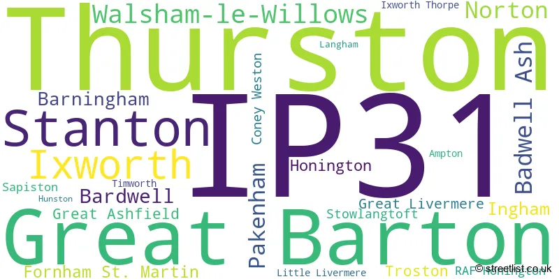
The largest settlement in the IP31 postal code is Thurston followed by Stanton, and Great Barton.
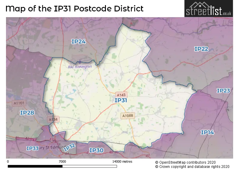
The IP31 Postcode shares a border with IP28 (Mildenhall, Red Lodge, Beck Row), IP14 (STOWMARKET, Stowupland, Debenham), IP22 (DISS, Roydon, Rickinghall), IP30 (Elmswell, Woolpit, Cockfield), IP24 (THETFORD, Great Hockham, Elveden) and IP32 (BURY ST. EDMUNDS).
The primary settlement in the IP31 postcode district is Bury St. Edmunds, located in the county of Suffolk in England. Other significant settlements within this district include Great Barton, Ixworth, Pakenham, and Stanton.
For the district IP31, we have data on 3 postcode sectors. Here's a breakdown: The sector IP31 1, covers Bardwell and Barningham and Ingham in Suffolk. The sector IP31 2, covers Great Barton and Stanton and Ixworth and Pakenham in Suffolk. The sector IP31 3, covers Thurston and Walsham-Le-Willows and Badwell Ash and Norton in Suffolk.

Map of the IP31 Postcode District
Explore the IP31 postcode district by using our free interactive map.
When it comes to local government, postal geography often disregards political borders. However, for a breakdown in the IP31 District: the district mostly encompasses the West Suffolk District (471 postcodes), and finally, the Mid Suffolk District area (292 postcodes).
Recent House Sales in IP31
| Date | Price | Address |
|---|---|---|
| 28/09/2023 | £520,000 | Conyers Way, Great Barton, Bury St Edmunds, IP31 2SW |
| 25/09/2023 | £677,000 | Long Thurlow, Bury St Edmunds, IP31 3JF |
| 15/09/2023 | £210,000 | Mill Road, Great Barton, Bury St Edmunds, IP31 2RY |
| 08/09/2023 | £350,000 | Bobbys Way, Stanton, Bury St Edmunds, IP31 2FE |
| 04/09/2023 | £480,000 | Barleyfields, Thurston, Bury St Edmunds, IP31 3TF |
| 04/09/2023 | £362,500 | Mill Lane, Thurston, Bury St Edmunds, IP31 3QA |
| 30/08/2023 | £346,000 | Coddington Way, Ixworth, Bury St Edmunds, IP31 2ET |
| 25/08/2023 | £302,000 | Victoria Close, Thurston, Bury St Edmunds, IP31 3SX |
| 25/08/2023 | £240,000 | Bobbys Way, Stanton, Bury St Edmunds, IP31 2FE |
| 25/08/2023 | £425,000 | Mere Close, Great Barton, Bury St Edmunds, IP31 2PE |
Weather Forecast for IP31
Press Button to Show Forecast for Ixworth
| Time Period | Icon | Description | Temperature | Rain Probability | Wind |
|---|---|---|---|---|---|
| 00:00 to 03:00 | Cloudy | 5.0°C (feels like 3.0°C) | 7.00% | ENE 4 mph | |
| 03:00 to 06:00 | Overcast | 5.0°C (feels like 3.0°C) | 17.00% | NE 7 mph | |
| 06:00 to 09:00 | Light rain | 6.0°C (feels like 4.0°C) | 53.00% | NE 7 mph | |
| 09:00 to 12:00 | Light rain | 7.0°C (feels like 4.0°C) | 59.00% | NE 11 mph | |
| 12:00 to 15:00 | Overcast | 9.0°C (feels like 6.0°C) | 22.00% | ENE 11 mph | |
| 15:00 to 18:00 | Overcast | 10.0°C (feels like 8.0°C) | 48.00% | NE 9 mph | |
| 18:00 to 21:00 | Cloudy | 10.0°C (feels like 7.0°C) | 48.00% | NE 9 mph | |
| 21:00 to 00:00 | Overcast | 8.0°C (feels like 6.0°C) | 58.00% | NE 9 mph |
Press Button to Show Forecast for Ixworth
| Time Period | Icon | Description | Temperature | Rain Probability | Wind |
|---|---|---|---|---|---|
| 00:00 to 03:00 | Heavy rain | 8.0°C (feels like 5.0°C) | 87.00% | NNE 11 mph | |
| 03:00 to 06:00 | Heavy rain | 8.0°C (feels like 6.0°C) | 89.00% | NNE 9 mph | |
| 06:00 to 09:00 | Heavy rain | 9.0°C (feels like 7.0°C) | 87.00% | ENE 7 mph | |
| 09:00 to 12:00 | Heavy rain shower (day) | 10.0°C (feels like 8.0°C) | 65.00% | WSW 11 mph | |
| 12:00 to 15:00 | Heavy rain shower (day) | 10.0°C (feels like 7.0°C) | 61.00% | W 11 mph | |
| 15:00 to 18:00 | Light rain | 10.0°C (feels like 7.0°C) | 51.00% | WNW 11 mph | |
| 18:00 to 21:00 | Partly cloudy (day) | 10.0°C (feels like 8.0°C) | 10.00% | WSW 7 mph | |
| 21:00 to 00:00 | Partly cloudy (night) | 8.0°C (feels like 5.0°C) | 5.00% | SW 9 mph |
Press Button to Show Forecast for Ixworth
| Time Period | Icon | Description | Temperature | Rain Probability | Wind |
|---|---|---|---|---|---|
| 00:00 to 03:00 | Clear night | 7.0°C (feels like 4.0°C) | 2.00% | SW 7 mph | |
| 03:00 to 06:00 | Clear night | 5.0°C (feels like 3.0°C) | 1.00% | SSW 7 mph | |
| 06:00 to 09:00 | Sunny day | 6.0°C (feels like 4.0°C) | 2.00% | S 7 mph | |
| 09:00 to 12:00 | Partly cloudy (day) | 12.0°C (feels like 10.0°C) | 1.00% | SSW 9 mph | |
| 12:00 to 15:00 | Cloudy | 14.0°C (feels like 11.0°C) | 6.00% | S 11 mph | |
| 15:00 to 18:00 | Partly cloudy (day) | 14.0°C (feels like 12.0°C) | 3.00% | S 11 mph | |
| 18:00 to 21:00 | Sunny day | 13.0°C (feels like 11.0°C) | 1.00% | SSE 9 mph | |
| 21:00 to 00:00 | Clear night | 9.0°C (feels like 7.0°C) | 1.00% | SE 9 mph |
Press Button to Show Forecast for Ixworth
| Time Period | Icon | Description | Temperature | Rain Probability | Wind |
|---|---|---|---|---|---|
| 00:00 to 03:00 | Clear night | 8.0°C (feels like 6.0°C) | 2.00% | SE 7 mph | |
| 03:00 to 06:00 | Clear night | 7.0°C (feels like 5.0°C) | 4.00% | SE 7 mph | |
| 06:00 to 09:00 | Cloudy | 9.0°C (feels like 7.0°C) | 8.00% | ESE 7 mph | |
| 09:00 to 12:00 | Cloudy | 13.0°C (feels like 12.0°C) | 9.00% | ESE 9 mph | |
| 12:00 to 15:00 | Cloudy | 15.0°C (feels like 14.0°C) | 11.00% | SE 9 mph | |
| 15:00 to 18:00 | Cloudy | 16.0°C (feels like 14.0°C) | 9.00% | SE 9 mph | |
| 18:00 to 21:00 | Cloudy | 14.0°C (feels like 13.0°C) | 8.00% | ESE 9 mph | |
| 21:00 to 00:00 | Cloudy | 12.0°C (feels like 10.0°C) | 19.00% | ESE 7 mph |
Where is the IP31 Postcode District?
The postcode district of IP31 is located in Bury St. Edmunds, which is a district town. Bury St. Edmunds is situated near several other towns. To the northwest is Thetford, which is approximately 9.6 miles away. To the southeast is Stowmarket, which is approximately 9.6 miles away. To the north is Norwich, which is around 10.9 miles away. To the east is Eye, which is approximately 13.6 miles away. To the northeast is Diss, which is around 13.8 miles away. To the west is Newmarket, which is approximately 18 miles away. To the south is Sudbury, which is around 18.3 miles away. Additionally, the distance from Bury St. Edmunds to the center of London is approximately 68.6 miles.
The district is within the post town of BURY ST. EDMUNDS.
The sector has postcodes within the nation of England.
The IP31 Postcode District is in the Suffolk region of East Anglia within the East of England.
| Postcode Sector | Delivery Office |
|---|---|
| IP31 1 | Bardwell Scale Payment Delivery Office |
| IP31 1 | Barningham Scale Payment Delivery Office |
| IP31 1 | Honington Scale Payment Delivery Office |
| IP31 1 | Ixworth Scale Payment Delivery Office |
| IP31 1 | Bury St. Edmunds Delivery Office |
| IP31 2 | Ixworth Scale Payment Delivery Office |
| IP31 2 | Bury St. Edmunds Delivery Office |
| IP31 2 | Great Barton Scale Payment Delivery Office |
| IP31 2 | Stanton Scale Payment Delivery Office |
| IP31 3 | Bury St. Edmunds Delivery Office |
| IP31 3 | Thurston Scale Payment Delivery Office |
| I | P | 3 | 1 | - | X | X | X |
| I | P | 3 | 1 | Space | Numeric | Letter | Letter |
Tourist Attractions within the Postcode Area
We found 1 visitor attractions within the IP31 postcode area
| Wyken Hall Gardens and Wyken Vineyards |
|---|
| Gardens |
| Garden |
| View Wyken Hall Gardens and Wyken Vineyards on Google Maps |
Current Monthly Rental Prices
| # Bedrooms | Min Price | Max Price | Avg Price |
|---|---|---|---|
| 1 | £800 | £825 | £817 |
| 2 | £900 | £1,400 | £1,167 |
| 3 | £900 | £1,600 | £1,281 |
| 4 | £1,535 | £2,300 | £2,026 |
| 5 | £2,300 | £2,300 | £2,300 |
Current House Prices
| # Bedrooms | Min Price | Max Price | Avg Price |
|---|---|---|---|
| £375,000 | £650,000 | £546,667 | |
| 1 | £55,000 | £55,000 | £55,000 |
| 2 | £97,500 | £375,000 | £224,218 |
| 3 | £159,998 | £850,000 | £380,602 |
| 4 | £200,000 | £1,150,000 | £520,089 |
| 5 | £450,000 | £1,600,000 | £814,285 |
| 6 | £860,000 | £1,500,000 | £1,163,333 |
| 8 | £5,250,000 | £5,250,000 | £5,250,000 |
Estate Agents who Operate in the IP31 District
| Logo | Name | Brand Name | Address | Contact Number | Total Properties |
|---|---|---|---|---|---|
 | Thurston | All Homes | 28 Thurston Granary Station Hill Thurston IP31 3QU | 020 3872 4809 | 25 |
 | Bury St Edmunds | Sheridans | 19 Langton Place, Bury St Edmunds, IP33 1NE | 01284 333376 | 19 |
 | Bury St Edmunds | Mark Ewin | 77 St. Johns Street, Bury St. Edmunds, IP33 1SQ | 01284 336099 | 12 |
 | Bury St. Edmunds | haart | 59 Cornhill, Bury St. Edmunds, IP33 1BE | 01284 332559 | 12 |
 | Bury St. Edmunds | William H. Brown | 12 The Traverse, Bury St. Edmunds, IP33 1BJ | 01284 658154 | 8 |
- Badwell Ash
- Bardwell
- Barnham
- Barningham
- Beyton
- Bury St Edmunds
- Coney Weston
- Conyer's Green
- Daisy Green
- Fornham St Martin
- Four Ashes
- Great Ashfield
- Great Barton
- Great Green
- Great Livermere
- Grimstone End
- Honington
- Hunston
- Ingham
- Ixworth
- Ixworth Thorpe
- Long Thurlow
- Longfield Green
- Norton
- Norton Little Green
- Pakenham
- Sapiston
- Stanton
- Stanton Chare
- Stanton Street
- Stockhold Green
- Stowlangtoft
- Thurston
- Timworth
- Tostock
- Troston
- Upthorpe
- Walsham le Willows
- Woodside View
| Type of Property | 2018 Average | 2018 Sales | 2017 Average | 2017 Sales | 2016 Average | 2016 Sales | 2015 Average | 2015 Sales |
|---|---|---|---|---|---|---|---|---|
| Detached | £450,278 | 175 | £434,855 | 191 | £369,472 | 214 | £349,803 | 213 |
| Semi-Detached | £257,766 | 63 | £263,950 | 80 | £226,390 | 94 | £220,817 | 98 |
| Terraced | £219,562 | 35 | £217,061 | 49 | £221,059 | 61 | £202,857 | 57 |
| Flats | £186,667 | 3 | £124,429 | 7 | £171,803 | 13 | £128,248 | 12 |