The IP32 postcode district is a postal district located in the IP Ipswich postcode area with a population of 18,031 residents according to the 2021 England and Wales Census.
The area of the IP32 postcode district is 3.03 square miles which is 7.84 square kilometres or 1,936.87 acres.
Currently, the IP32 district has about 414 postcode units spread across 2 geographic postcode sectors.
Given that each sector allows for 400 unique postcode combinations, the district has a capacity of 800 postcodes. With 414 postcodes already in use, this leaves 386 units available.
The IP32 postal code covers the settlement of BURY ST. EDMUNDS.
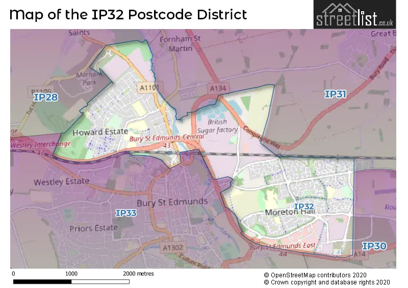
The IP32 Postcode shares a border with IP28 (Mildenhall, Red Lodge, Beck Row), IP30 (Elmswell, Woolpit, Cockfield), IP31 (Thurston, Stanton, Great Barton) and IP33 (BURY ST. EDMUNDS).
The primary settlement in the IP32 postcode district is Bury St. Edmunds, which is located in the county of Suffolk. Bury St. Edmunds is also the main post town for this postcode district.
For the district IP32, we have data on 2 postcode sectors. Here's a breakdown: The sector IP32 6, covers Bury St. Edmunds in Suffolk. The sector IP32 7, covers Bury St. Edmunds in Suffolk.


Map of the IP32 Postcode District
Explore the IP32 postcode district by using our free interactive map.
When it comes to local government, postal geography often disregards political borders. However, for a breakdown in the IP32 District: the district mostly encompasses the West Suffolk District area with a total of 451 postcodes.
Recent House Sales in IP32
| Date | Price | Address |
|---|---|---|
| 16/10/2023 | £150,000 | Juniper Road, Bury St Edmunds, IP32 7PT |
| 27/09/2023 | £140,000 | Airfield Road, Bury St Edmunds, IP32 7RH |
| 26/09/2023 | £375,000 | Jermyn Avenue, Bury St Edmunds, IP32 7LD |
| 15/09/2023 | £275,000 | Station Hill, Bury St Edmunds, IP32 6AF |
| 15/09/2023 | £225,000 | Sutton Close, Bury St Edmunds, IP32 7EP |
| 01/09/2023 | £172,500 | Forum Court, Bury St Edmunds, IP32 6BP |
| 01/09/2023 | £264,000 | Greenways Crescent, Bury St Edmunds, IP32 7JP |
| 29/08/2023 | £297,000 | Darby Close, Bury St Edmunds, IP32 7LE |
| 25/08/2023 | £350,000 | Bluebell Avenue, Bury St Edmunds, IP32 7JW |
| 23/08/2023 | £545,000 | Daisy Avenue, Bury St Edmunds, IP32 7PG |
Weather Forecast for IP32
Press Button to Show Forecast for Bury St. Edmunds
| Time Period | Icon | Description | Temperature | Rain Probability | Wind |
|---|---|---|---|---|---|
| 06:00 to 09:00 | Heavy rain | 6.0°C (feels like 4.0°C) | 79.00% | NE 7 mph | |
| 09:00 to 12:00 | Light rain | 7.0°C (feels like 4.0°C) | 59.00% | NE 9 mph | |
| 12:00 to 15:00 | Overcast | 9.0°C (feels like 7.0°C) | 23.00% | ENE 11 mph | |
| 15:00 to 18:00 | Overcast | 10.0°C (feels like 8.0°C) | 50.00% | NE 9 mph | |
| 18:00 to 21:00 | Cloudy | 10.0°C (feels like 7.0°C) | 50.00% | NE 9 mph | |
| 21:00 to 00:00 | Overcast | 8.0°C (feels like 6.0°C) | 56.00% | NE 9 mph |
Press Button to Show Forecast for Bury St. Edmunds
| Time Period | Icon | Description | Temperature | Rain Probability | Wind |
|---|---|---|---|---|---|
| 00:00 to 03:00 | Heavy rain | 8.0°C (feels like 5.0°C) | 87.00% | NNE 11 mph | |
| 03:00 to 06:00 | Heavy rain | 8.0°C (feels like 6.0°C) | 89.00% | NNE 9 mph | |
| 06:00 to 09:00 | Heavy rain | 9.0°C (feels like 7.0°C) | 87.00% | NE 7 mph | |
| 09:00 to 12:00 | Heavy rain shower (day) | 10.0°C (feels like 8.0°C) | 66.00% | WSW 11 mph | |
| 12:00 to 15:00 | Heavy rain shower (day) | 10.0°C (feels like 7.0°C) | 62.00% | W 11 mph | |
| 15:00 to 18:00 | Light rain | 10.0°C (feels like 7.0°C) | 51.00% | WNW 11 mph | |
| 18:00 to 21:00 | Partly cloudy (day) | 10.0°C (feels like 8.0°C) | 10.00% | WSW 7 mph | |
| 21:00 to 00:00 | Partly cloudy (night) | 7.0°C (feels like 5.0°C) | 5.00% | SW 9 mph |
Press Button to Show Forecast for Bury St. Edmunds
| Time Period | Icon | Description | Temperature | Rain Probability | Wind |
|---|---|---|---|---|---|
| 00:00 to 03:00 | Clear night | 6.0°C (feels like 4.0°C) | 2.00% | SW 7 mph | |
| 03:00 to 06:00 | Clear night | 5.0°C (feels like 3.0°C) | 1.00% | SSW 7 mph | |
| 06:00 to 09:00 | Sunny day | 6.0°C (feels like 4.0°C) | 2.00% | S 7 mph | |
| 09:00 to 12:00 | Partly cloudy (day) | 11.0°C (feels like 9.0°C) | 1.00% | SSW 9 mph | |
| 12:00 to 15:00 | Cloudy | 14.0°C (feels like 11.0°C) | 6.00% | S 11 mph | |
| 15:00 to 18:00 | Partly cloudy (day) | 14.0°C (feels like 12.0°C) | 3.00% | S 11 mph | |
| 18:00 to 21:00 | Sunny day | 13.0°C (feels like 11.0°C) | 1.00% | SSE 9 mph | |
| 21:00 to 00:00 | Clear night | 9.0°C (feels like 7.0°C) | 1.00% | SE 9 mph |
Press Button to Show Forecast for Bury St. Edmunds
| Time Period | Icon | Description | Temperature | Rain Probability | Wind |
|---|---|---|---|---|---|
| 00:00 to 03:00 | Clear night | 8.0°C (feels like 6.0°C) | 2.00% | SE 7 mph | |
| 03:00 to 06:00 | Clear night | 7.0°C (feels like 5.0°C) | 4.00% | SE 7 mph | |
| 06:00 to 09:00 | Cloudy | 9.0°C (feels like 7.0°C) | 8.00% | ESE 7 mph | |
| 09:00 to 12:00 | Cloudy | 13.0°C (feels like 12.0°C) | 9.00% | ESE 9 mph | |
| 12:00 to 15:00 | Cloudy | 15.0°C (feels like 14.0°C) | 11.00% | SE 9 mph | |
| 15:00 to 18:00 | Cloudy | 16.0°C (feels like 14.0°C) | 9.00% | SE 9 mph | |
| 18:00 to 21:00 | Cloudy | 14.0°C (feels like 13.0°C) | 8.00% | ESE 9 mph | |
| 21:00 to 00:00 | Cloudy | 12.0°C (feels like 10.0°C) | 19.00% | ESE 7 mph |
Where is the IP32 Postcode District?
The data's postcode district is located in Bury St. Edmunds. It is surrounded by nearby towns such as Stowmarket to the East, Thetford to the North, Newmarket to the West, Brandon to the North West, Sudbury to the South, Norwich to the North East, and Haverhill to the South West. The district is situated approximately 63.15 miles away from the center of London.
The district is within the post town of BURY ST. EDMUNDS.
The sector has postcodes within the nation of England.
The IP32 Postcode District is in the region of within the .
| Postcode Sector | Delivery Office |
|---|---|
| IP32 6 | Bury St. Edmunds Delivery Office |
| IP32 7 | Bury St. Edmunds Delivery Office |
| I | P | 3 | 2 | - | X | X | X |
| I | P | 3 | 2 | Space | Numeric | Letter | Letter |
Current Monthly Rental Prices
| # Bedrooms | Min Price | Max Price | Avg Price |
|---|---|---|---|
| 2 | £975 | £1,750 | £1,303 |
| 3 | £1,000 | £1,700 | £1,369 |
| 4 | £1,500 | £2,100 | £1,652 |
| 5 | £2,100 | £2,100 | £2,100 |
| 6 | £2,600 | £2,600 | £2,600 |
Current House Prices
| # Bedrooms | Min Price | Max Price | Avg Price |
|---|---|---|---|
| 1 | £63,000 | £180,000 | £145,833 |
| 2 | £130,000 | £325,000 | £221,961 |
| 3 | £113,750 | £425,000 | £313,966 |
| 4 | £255,000 | £640,000 | £443,042 |
| 5 | £499,950 | £625,000 | £566,650 |
| 6 | £625,000 | £950,000 | £787,500 |
Estate Agents who Operate in the IP32 District
| Logo | Name | Brand Name | Address | Contact Number | Total Properties |
|---|---|---|---|---|---|
 | Bury St. Edmunds | haart | 59 Cornhill, Bury St. Edmunds, IP33 1BE | 01284 332559 | 26 |
 | Bury St Edmunds | Mark Ewin | 77 St. Johns Street, Bury St. Edmunds, IP33 1SQ | 01284 336099 | 12 |
 | Bury St. Edmunds | William H. Brown | 12 The Traverse, Bury St. Edmunds, IP33 1BJ | 01284 658154 | 9 |
 | Bury St Edmunds | Martin & Co | Crescent House 28 Angel Hill, Bury St. Edmunds, IP33 1UZ | 01284 333374 | 9 |
 | Bury St Edmunds | Isaac Estates | 12 Langton Place Hatter Street Bury St Edmunds Suffolk IP33 1NE | 01284 620011 | 7 |
| Type of Property | 2018 Average | 2018 Sales | 2017 Average | 2017 Sales | 2016 Average | 2016 Sales | 2015 Average | 2015 Sales |
|---|---|---|---|---|---|---|---|---|
| Detached | £411,160 | 135 | £376,148 | 88 | £361,057 | 60 | £340,425 | 64 |
| Semi-Detached | £278,785 | 95 | £263,933 | 70 | £250,358 | 63 | £228,593 | 72 |
| Terraced | £241,519 | 111 | £231,462 | 100 | £214,733 | 105 | £200,358 | 115 |
| Flats | £165,867 | 39 | £163,381 | 34 | £144,895 | 43 | £134,244 | 34 |