The IP9 postcode district is a postal district located in the IP Ipswich postcode area with a population of 11,663 residents according to the 2021 England and Wales Census.
The area of the IP9 postcode district is 33.21 square miles which is 86.00 square kilometres or 21,251.49 acres.
Currently, the IP9 district has about 479 postcode units spread across 2 geographic postcode sectors.
Given that each sector allows for 400 unique postcode combinations, the district has a capacity of 800 postcodes. With 479 postcodes already in use, this leaves 321 units available.
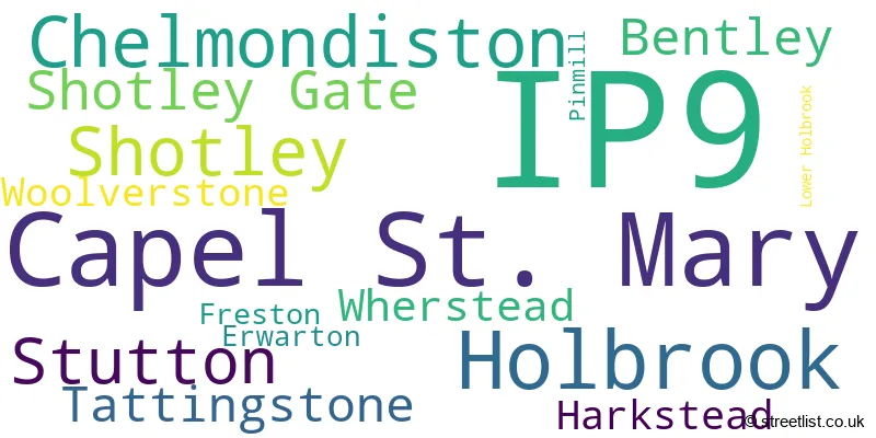
The largest settlement in the IP9 postal code is Capel St. Mary followed by Holbrook, and Shotley Gate.
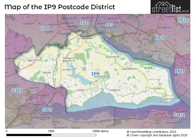
The postcode area has a boundary with Harwich Harbour.
The IP9 Postcode shares a border with IP2 (IPSWICH, Wherstead), IP3 (IPSWICH, Purdis Farm), IP8 (Bramford, IPSWICH, Sproughton), CO11 (Lawford, Mistley, Brantham) and CO7 (Brightlingsea, Wivenhoe, Great Bentley).
The primary settlement in the IP9 postcode district is Chelmondiston in the county of Suffolk, England. Other significant settlements include Erwarton, Freston, Harkstead, Pinmill, Shotley, Shotley Gate, and Woolverstone. The main post town in this postcode district is Ipswich.
For the district IP9, we have data on 2 postcode sectors. Here's a breakdown: The sector IP9 1, covers Chelmondiston and Shotley and Shotley Gate and Harkstead and Woolverstone in Suffolk. The sector IP9 2, covers Capel St. Mary and Holbrook and Stutton in Suffolk.

Map of the IP9 Postcode District
Explore the IP9 postcode district by using our free interactive map.
When it comes to local government, postal geography often disregards political borders. However, for a breakdown in the IP9 District: the district mostly encompasses the Babergh District (489 postcodes), and finally, the Ipswich District (B) area (3 postcodes).
Recent House Sales in IP9
| Date | Price | Address |
|---|---|---|
| 15/09/2023 | £310,000 | Farthings Went, Capel St Mary, Ipswich, IP9 2UJ |
| 08/09/2023 | £167,000 | Kingsland, Shotley, Ipswich, IP9 1NB |
| 01/09/2023 | £275,000 | The Heath, Tattingstone, Ipswich, IP9 2LX |
| 01/09/2023 | £255,000 | Grove Road, Bentley, Ipswich, IP9 2DD |
| 31/08/2023 | £340,000 | Pipistrelle Way, Capel St Mary, Ipswich, IP9 2RH |
| 30/08/2023 | £181,000 | Main Road, Chelmondiston, Ipswich, IP9 1EB |
| 21/08/2023 | £440,000 | Clifton Wood, Holbrook, Ipswich, IP9 2PY |
| 18/08/2023 | £358,000 | Ipswich Road, Harkstead, Ipswich, IP9 1BJ |
| 14/08/2023 | £730,000 | Bentley, Ipswich, IP9 2LT |
| 11/08/2023 | £220,000 | Garden Close, Shotley, Ipswich, IP9 1LZ |
Weather Forecast for IP9
Press Button to Show Forecast for Suffolk Ski Centre
| Time Period | Icon | Description | Temperature | Rain Probability | Wind |
|---|---|---|---|---|---|
| 06:00 to 09:00 | Heavy rain | 7.0°C (feels like 4.0°C) | 86.00% | NE 11 mph | |
| 09:00 to 12:00 | Light rain | 8.0°C (feels like 5.0°C) | 51.00% | NE 13 mph | |
| 12:00 to 15:00 | Light rain | 11.0°C (feels like 9.0°C) | 45.00% | ENE 9 mph | |
| 15:00 to 18:00 | Cloudy | 12.0°C (feels like 10.0°C) | 7.00% | E 9 mph | |
| 18:00 to 21:00 | Cloudy | 11.0°C (feels like 8.0°C) | 14.00% | ENE 11 mph | |
| 21:00 to 00:00 | Heavy rain | 10.0°C (feels like 7.0°C) | 85.00% | NE 13 mph |
Press Button to Show Forecast for Suffolk Ski Centre
| Time Period | Icon | Description | Temperature | Rain Probability | Wind |
|---|---|---|---|---|---|
| 00:00 to 03:00 | Heavy rain | 10.0°C (feels like 7.0°C) | 91.00% | NE 11 mph | |
| 03:00 to 06:00 | Heavy rain | 10.0°C (feels like 8.0°C) | 89.00% | E 9 mph | |
| 06:00 to 09:00 | Light rain | 10.0°C (feels like 7.0°C) | 62.00% | SSW 13 mph | |
| 09:00 to 12:00 | Light rain shower (day) | 11.0°C (feels like 8.0°C) | 47.00% | SSE 16 mph | |
| 12:00 to 15:00 | Heavy rain shower (day) | 11.0°C (feels like 8.0°C) | 63.00% | SW 16 mph | |
| 15:00 to 18:00 | Light rain shower (day) | 11.0°C (feels like 8.0°C) | 43.00% | WSW 16 mph | |
| 18:00 to 21:00 | Cloudy | 10.0°C (feels like 8.0°C) | 11.00% | WSW 11 mph | |
| 21:00 to 00:00 | Cloudy | 9.0°C (feels like 6.0°C) | 6.00% | SW 9 mph |
Press Button to Show Forecast for Suffolk Ski Centre
| Time Period | Icon | Description | Temperature | Rain Probability | Wind |
|---|---|---|---|---|---|
| 00:00 to 03:00 | Clear night | 7.0°C (feels like 5.0°C) | 1.00% | SW 9 mph | |
| 03:00 to 06:00 | Clear night | 6.0°C (feels like 4.0°C) | 2.00% | SW 7 mph | |
| 06:00 to 09:00 | Sunny day | 8.0°C (feels like 6.0°C) | 1.00% | SSW 7 mph | |
| 09:00 to 12:00 | Sunny day | 11.0°C (feels like 9.0°C) | 1.00% | S 11 mph | |
| 12:00 to 15:00 | Partly cloudy (day) | 13.0°C (feels like 10.0°C) | 2.00% | SSE 11 mph | |
| 15:00 to 18:00 | Partly cloudy (day) | 13.0°C (feels like 11.0°C) | 2.00% | SSE 13 mph | |
| 18:00 to 21:00 | Sunny day | 12.0°C (feels like 10.0°C) | 1.00% | SE 11 mph | |
| 21:00 to 00:00 | Clear night | 10.0°C (feels like 8.0°C) | 2.00% | SE 9 mph |
Press Button to Show Forecast for Suffolk Ski Centre
| Time Period | Icon | Description | Temperature | Rain Probability | Wind |
|---|---|---|---|---|---|
| 00:00 to 03:00 | Cloudy | 9.0°C (feels like 7.0°C) | 6.00% | SE 7 mph | |
| 03:00 to 06:00 | Cloudy | 9.0°C (feels like 7.0°C) | 7.00% | E 7 mph | |
| 06:00 to 09:00 | Overcast | 10.0°C (feels like 9.0°C) | 11.00% | ESE 9 mph | |
| 09:00 to 12:00 | Overcast | 13.0°C (feels like 11.0°C) | 14.00% | SE 9 mph | |
| 12:00 to 15:00 | Cloudy | 14.0°C (feels like 12.0°C) | 8.00% | SE 9 mph | |
| 15:00 to 18:00 | Cloudy | 14.0°C (feels like 13.0°C) | 7.00% | ESE 9 mph | |
| 18:00 to 21:00 | Cloudy | 13.0°C (feels like 12.0°C) | 7.00% | E 9 mph | |
| 21:00 to 00:00 | Cloudy | 12.0°C (feels like 10.0°C) | 20.00% | E 9 mph |
Where is the IP9 Postcode District?
The IP9 postcode district is located in Ipswich. Ipswich is surrounded by several nearby towns in different directions. Manningtree is located to the South West, Harwich to the South East, Felixstowe to the East, Woodbridge to the North East, Clacton-on-Sea to the South, and Stowmarket to the North West. Moreover, the IP9 postcode district is approximately 64.1 miles away from the center of London.
The district is within the post town of IPSWICH.
The sector has postcodes within the nation of England.
The IP9 Postcode District is in the Suffolk region of East Anglia within the East of England.
| Postcode Sector | Delivery Office |
|---|---|
| IP9 1 | Ipswich Delivery Office |
| IP9 2 | Ipswich Delivery Office |
| IP9 2 | Capel St Mary Scale Payment Delivery Office |
| I | P | 9 | - | X | X | X |
| I | P | 9 | Space | Numeric | Letter | Letter |
Current Monthly Rental Prices
| # Bedrooms | Min Price | Max Price | Avg Price |
|---|---|---|---|
| 1 | £595 | £595 | £595 |
| 2 | £975 | £1,275 | £1,167 |
| 3 | £1,400 | £1,400 | £1,400 |
| 4 | £2,000 | £2,000 | £2,000 |
Current House Prices
| # Bedrooms | Min Price | Max Price | Avg Price |
|---|---|---|---|
| £210,000 | £210,000 | £210,000 | |
| 1 | £25,000 | £25,000 | £25,000 |
| 2 | £120,000 | £415,000 | £300,000 |
| 3 | £85,750 | £1,000,000 | £356,796 |
| 4 | £300,000 | £1,250,000 | £553,038 |
| 5 | £470,000 | £5,000,000 | £1,544,000 |
| 6 | £575,000 | £1,750,000 | £1,162,500 |
| 10 | £900,000 | £900,000 | £900,000 |
Estate Agents who Operate in the IP9 District
| Logo | Name | Brand Name | Address | Contact Number | Total Properties |
|---|---|---|---|---|---|
 | Suffolk | Palmer & Partners | 2 St. Nicholas Street Ipswich IP1 1TJ | 01473 211705 | 13 |
 | Ipswich | Fenn Wright | 1 Buttermarket, Ipswich, IP1 1BA | 01473 943943 | 8 |
 | Ipswich | Foxhall Estate Agents | 625 Foxhall Road, Ipswich, IP3 8ND | 01473 943315 | 7 |
 | East Bergholt | Grier & Partners | The Street, East Bergholt, CO7 6TF | 01206 586076 | 6 |
 | Ipswich | Connells | 6 Princes Street, Ipswich, IP1 1QT | 01473 943139 | 6 |
- Bentley
- Blacksmith's Corner
- Brantham
- Capel St Mary
- Chelmondiston
- Church End
- East Bergholt
- Erwarton
- Freston
- Harkstead
- Holbrook
- Ipswich
- Lattinford Hill
- Little Wenham
- Lower Holbrook
- Potash
- Shotley Common
- Shotley Gate
- Shotley
- Stutton
- Tattingstone
- Tattingstone White Horse
- Upper Street
- Wherstead
- Woolverstone
| Type of Property | 2018 Average | 2018 Sales | 2017 Average | 2017 Sales | 2016 Average | 2016 Sales | 2015 Average | 2015 Sales |
|---|---|---|---|---|---|---|---|---|
| Detached | £408,168 | 89 | £410,251 | 98 | £424,709 | 71 | £345,567 | 82 |
| Semi-Detached | £278,590 | 53 | £256,757 | 55 | £247,633 | 50 | £207,499 | 49 |
| Terraced | £232,050 | 30 | £235,534 | 22 | £223,946 | 27 | £217,795 | 33 |
| Flats | £171,383 | 15 | £90,596 | 13 | £101,300 | 10 | £73,611 | 9 |