This section of the site is all about the NR Postcode area, also known as the Norwich Postal Area. Explore links to the next level to learn more about specific postcode districts such as NR1.
The NR postcode area represents a group of postal districts in the Norwich area of the United Kingdom. The area code NR stands for the letters n and r in NoRwich. NR has a population of 722,087 and covers an area of 3,326,381 hectares. Fun fact: 1.11% of the population of Great Britain lives in this area.
The postcode area falls within the following counties: Norfolk (87.65%), Suffolk (12.35%).
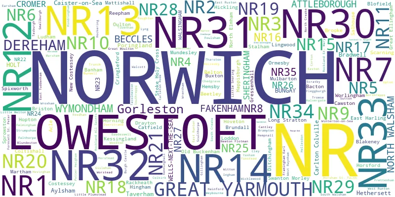
Post Towns and Postcode Districts for the NR Postcode
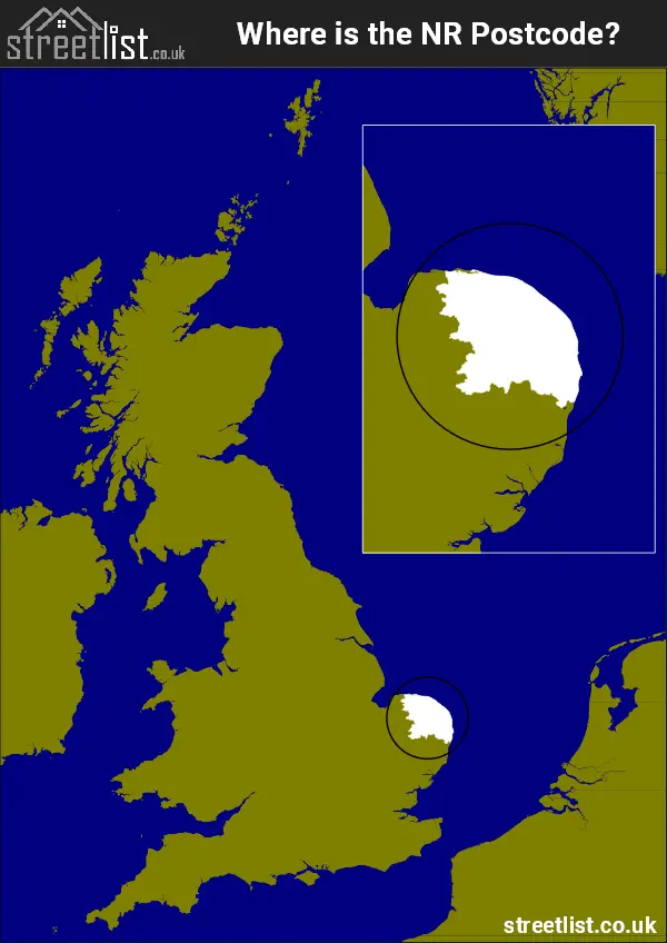
Where is the NR Postcode Area?
The NR Norwich Postcode is in the East of England. The postal area borders the following neighbouring postal areas: PE - Peterborough and IP - Ipswich, It also borders The North Sea,
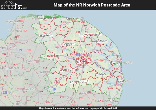
Map of the NR Norwich Postcode Area
Explore the NR Norwich postcode area by using our interactive map.
Postcode Districts within the NR Norwich Postcode Area
There are 35 postcode districts within the Norwich postcode area
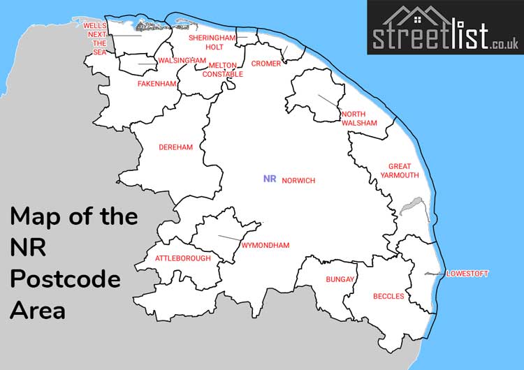
A map showing the boundary of in relation to other areas
There are 19 towns within the Norwich postcode area.
| Unit | Area² |
|---|---|
| Hectares | 3,326,381² |
| Miles | 12,843² |
| Feet | 358,048,324,459² |
| Kilometres | 33,264² |
Postal Delivery Offices serving the NR Norwich Postcode Area
- Acle Scale Payment Delivery Office
- Attleborough Scale Payment Delivery Office
- Aylsham Scale Payment Delivery Office
- Beccles Delivery Office
- Belton Scale Payment Delivery Office (nr)
- Blofield Scale Payment Delivery Office
- Bowthorpe Delivery Office
- Brooke Scale Payment Delivery Office
- Brundall Scale Payment Delivery Office
- Bungay Delivery Office
- Buxton (nr) Scale Payment Delivery Office
- Coltishall Scale Payment Delivery Office
- Cromer Delivery Office
- Dereham Delivery Office
- Drayton Scale Payment Delivery Office
- East Harling Scale Payment Delivery Office
- Fakenham Delivery Office
- Filby Scale Payment Delivery Office
- Framingham Earl Scale Payment Delivery Office
- Great Yarmouth Delivery Office
- Hemsby Scale Payment Delivery Office
- Hethersett Scale Payment Delivery Office
- Holt Delivery Office
- Horsford Scale Payment Delivery Office
- Lod Delivery Office N Scale Payment Delivery Office
- Long Stratton Scale Payment Delivery Office
- Lowestoft Delivery Office
- Ludham Scale Payment Delivery Office
- Lyng Scale Payment Delivery Office
- Martham Scale Payment Delivery Office
- Mattishall Scale Payment Delivery Office
- Mulbarton Scale Payment Delivery Office
- Mundesley Scale Payment Delivery Office
- Newton Flotman Scale Payment Delivery Office
- North Walsham Delivery Office
- Norwich Delivery Office
- Ormesby Scale Payment Delivery Office
- Potter Heigham Scale Payment Delivery Office
- Reedham Scale Payment Delivery Office
- Reepham Scale Payment Delivery Office
- Salhouse Scale Payment Delivery Office
- Sheringham Delivery Office
- Spixworth Scale Payment Delivery Office
- Stalham Scale Payment Delivery Office
- Wells Next The Sea Scale Payment Delivery Office
- Wroxham Scale Payment Delivery Office
- Wymondham Delivery Office
Councils with Postcodes in NR
Towns and Villages within the NR Norwich Postcode Area
- Acle - village
- Alby Hill - village
- Aldborough - village
- Aldeby - village
- Alpington - village
- Antingham - village
- Arminghall - village
- Ashby St Mary - village
- Ashmanhaugh - village
- Ashwellthorpe - village
- Aslacton - village
- Attleborough - town
- Attlebridge - village
- Aylmerton - village
- Aylsham - town
- Baconsthorpe - village
- Bacton - village
- Badersfield - village
- Bale - village
- Banham - village
- Banningham - village
- Barford - village
- Barnby - village
- Barney - village
- Barnham Broom - village
- Barton Turf - village
- Bastwick - village
- Bawburgh - village
- Bawdeswell - village
- Beccles - town
- Beeston Regis - village
- Beetley - village
- Beighton - village
- Belaugh - village
- Belton - village
- Bergh Apton - village
- Bessingham - village
- Besthorpe - village
- Billingford - village
- Binham - village
- Bintree - village
- Black Street - village
- Blakeney - village
- Blofield - village
- Blofield Heath - village
- Blundeston - village
- Bodham - village
- Booton - village
- Bracon Ash - village
- Bradfield - village
- Bradwell - village
- Bramerton - village
- Brampton - village
- Brampton - village
- Brampton Street - village
- Brandiston - village
- Breckles - otherSettlement
- Bridgham - village
- Briningham - village
- Brinton - village
- Brisley - village
- Briston - village
- Brooke - village
- Broome - village
- Broomholm - village
- Browston Green - village
- Brumstead - otherSettlement
- Brundall - village
- Bungay - town
- Bunwell - village
- Burgh Castle - village
- Burgh next Aylsham - village
- Burgh St Peter - village
- Butcher's Common - village
- Buxton - village
- Caister-on-Sea - town
- California - village
- Calthorpe - village
- Cantley - village
- Carleton Rode - village
- Caston - village
- Catfield - village
- Cawston - village
- Chedgrave - village
- Claxton - village
- Clay Common - village
- Cley next the Sea - village
- Clint Green - village
- Clippesby - otherSettlement
- Colkirk - village
- Colney - village
- Coltishall - village
- Colton - village
- Corpusty - village
- Corton - village
- Costessey - village
- Cringleford - village
- Cromer - town
- Crossdale Street - village
- Crostwick - village
- Damgate - village
- Deopham - village
- Deopham Green - village
- Dereham - town
- Dilham - village
- Ditchingham - village
- Drayton - village
- Earsham - village
- East Barsham - village
- East Bilney - village
- East Carleton - village
- East Harling - village
- East Runton - village
- East Ruston - village
- East Tuddenham - village
- Eastgate - village
- Easton - village
- Eccles on Sea - village
- Eccles Road - village
- Edgefield - village
- Edgefield Street - village
- Edingthorpe - village
- Ellingham - village
- Elsing - village
- Erpingham - village
- Etling Green - village
- Fakenham - town
- Felbrigg - village
- Felmingham - village
- Felthorpe - village
- Field Dalling - village
- Filby - village
- Fleggburgh - village
- Flixton - village
- Flordon - village
- Forncett End - village
- Forncett St Mary - village
- Forncett St Peter - village
- Foulsham - village
- Foxley - village
- Framingham Earl - village
- Freethorpe - village
- Frettenham - village
- Fritton - village
- Fritton - village
- Frostenden - village
- Fulmodeston - village
- Fundenhall - village
- Garvestone - village
- Geldeston - village
- Gillingham - village
- Gimingham - village
- Gorleston-on-Sea - town
- Great Ellingham - village
- Great Fransham - village
- Great Moulton - village
- Great Plumstead - village
- Great Ryburgh - village
- Great Snoring - village
- Great Walsingham - village
- Great Yarmouth - town
- Gresham - village
- Gressenhall - village
- Guist - village
- Gunthorpe - village
- Haddiscoe - village
- Hainford - village
- Hales - village
- Halvergate - village
- Happisburgh - village
- Happisburgh Common - village
- Hapton - village
- Hardingham - village
- Hardley Street - village
- Hardwick - village
- Harling Road - village
- Hedenham - village
- Helhoughton - village
- Hempnall - village
- Hempnall Green - village
- Hempstead - village
- Hempton - village
- Hemsby - village
- Henstead - village
- Hethersett - village
- Hevingham - village
- Hickling - village
- High Kelling - village
- Hindolveston - village
- Hindringham - village
- Hingham - town
- Hockering - village
- Holkham - village
- Holt - town
- Honing - village
- Honingham - village
- Hopton on Sea - village
- Horning - village
- Horningtoft - village
- Horsford - village
- Horsham St Faith - village
- Horstead - village
- Hoveton - village
- Hulver Street - village
- Hunworth - village
- Ilketshall St Andrew - village
- Ilketshall St Lawrence - village
- Ingham - village
- Ingham Corner - village
- Ingworth - village
- Itteringham - village
- Kelling - village
- Kenninghall - village
- Kerdiston - otherSettlement
- Kessingland - village
- Keswick - village
- Keswick - village
- Ketteringham - village
- Kettlestone - village
- Kimberley - village
- Kirby Cane - village
- Kirstead Green - village
- Knapton - village
- Lamas - village
- Langham - village
- Langley Street - village
- Lenwade - village
- Lessingham - village
- Letheringsett - village
- Limpenhoe - village
- Lingwood - village
- Little Barningham - village
- Little Ellingham - village
- Little Fransham - village
- Little Melton - village
- Little Plumstead - village
- Little Snoring - village
- Little Walsingham - village
- Loddon - town
- Long Stratton - village
- Longham - village
- Lound - village
- Lower Bodham - otherSettlement
- Lower East Carleton - village
- Lower Gresham - village
- Lower Tasburgh - village
- Lower Thurlton - village
- Lowestoft - town
- Ludham - village
- Lyng - village
- Lyngate - village
- Marlingford - village
- Marsham - village
- Martham - village
- Matlaske - village
- Mattishall - village
- Maypole Green - village
- Meeting House Hill - village
- Melton Constable - village
- Mettingham - village
- Morley St Botolph - village
- Morston - village
- Moulton St Mary - village
- Mulbarton - village
- Mundesley - village
- Mutford - village
- Neatishead - village
- New Buckenham - village
- New Holkham - otherSettlement
- Newport - village
- Newton Flotman - village
- Newton St Faith - village
- North Cove - village
- North Creake - village
- North Elmham - village
- North Tuddenham - village
- North Walsham - town
- Northrepps - village
- Norton Subcourse - village
- Norwich - city
- Old Beetley - village
- Old Brigg - otherSettlement
- Old Buckenham - village
- Ormesby St Margaret - village
- Ormesby St Michael - village
- Oulton Street - village
- Overstrand - village
- Paston - village
- Pedham - village
- Pilson Green - village
- Plumstead - village
- Podmore - otherSettlement
- Poringland - village
- Postwick - village
- Potter Heigham - village
- Pudding Norton - village
- Queen's Hills - village
- Quidenham - village
- Rackheath - village
- Ranworth - village
- Redisham - village
- Reedham - village
- Reymerston - village
- Ridlington - village
- Ringland - village
- Ringsfield Corner - village
- Rockland All Saints - village
- Rockland St Mary - village
- Rockland St Peter - village
- Rollesby - village
- Roughton - village
- Runham - village
- Salhouse - village
- Salthouse - village
- Saxlingham Nethergate - village
- Saxlingham Thorpe - village
- Saxthorpe - village
- Scarning - village
- Scottow - village
- Scoulton - village
- Scratby - village
- Sculthorpe - village
- Sea Palling - village
- Seething - village
- Sharrington - village
- Sheringham - town
- Shipmeadow - village
- Shotesham - village
- Shropham - village
- Sidestrand - village
- Silfield - village
- Smallburgh - village
- Sneath Common - village
- Somerleyton - village
- South Creake - village
- South Raynham - village
- South Walsham - village
- Southrepps - village
- Sparham - village
- Spixworth - village
- Spooner Row - village
- St Olaves - village
- Stalham - town
- Stanfield - village
- Stibbard - village
- Stiffkey - village
- Stody - otherSettlement
- Stoke Holy Cross - village
- Stokesby - village
- Stow Bedon - village
- Strumpshaw - village
- Surlingham - village
- Sustead - village
- Sutton - village
- Swafield - village
- Swainsthorpe - village
- Swannington - village
- Swanton Abbott - village
- Swanton Morley - village
- Swanton Novers - village
- Swardeston - village
- Tacolneston - village
- Tasburgh - village
- Taverham - village
- Tharston - village
- The Green - village
- The Heath - village
- Thornage - village
- Thorpe End - village
- Thorpe Market - village
- Thorpe Marriot - village
- Threehammer Common - village
- Thurgarton - village
- Thurlton - village
- Thurne - village
- Thursford - village
- Thursford Green - village
- Thurton - village
- Tibenham - village
- Tivetshall St Mary - village
- Toft Monks - village
- Topcroft - village
- Topcroft Street - village
- Toprow - village
- Trimingham - village
- Trowse Newton - village
- Trunch - village
- Tunstead - village
- Tuttington - village
- Uggeshall - village
- Upper Sheringham - village
- Upper Stoke - village
- Upper Street - village
- Upton - village
- Wacton - village
- Walcott - village
- Wangford - village
- Warham - village
- Waterloo - village
- Welborne - village
- Wells-next-the-Sea - town
- Wendling - village
- West Beckham - village
- West Raynham - village
- West Runton - village
- West Somerton - village
- Westfield - village
- Weston Longville - village
- Weybourne - village
- Whinburgh - village
- Whissonsett - village
- White Horse Common - village
- Whitwell - otherSettlement
- Wicken Green Village - village
- Wicklewood - village
- Wighton - village
- Willingham - village
- Winterton-on-Sea - village
- Witton - otherSettlement
- Witton - otherSettlement
- Wiveton - village
- Wood Norton - village
- Woodbastwick - village
- Woodgate - village
- Woodton - village
- Worlingham - village
- Worstead - village
- Wramplingham - village
- Wreningham - village
- Wrentham - village
- Wroxham - village
- Wymondham - town
- Yaxham - village
- Yelverton - village