The NR25 postcode district is a postal district located in the NR Norwich postcode area with a population of 8,740 residents according to the 2021 England and Wales Census.
The area of the NR25 postcode district is 45.26 square miles which is 117.22 square kilometres or 28,965.43 acres.
Currently, the NR25 district has about 526 postcode units spread across 2 geographic postcode sectors.
Given that each sector allows for 400 unique postcode combinations, the district has a capacity of 800 postcodes. With 526 postcodes already in use, this leaves 274 units available.
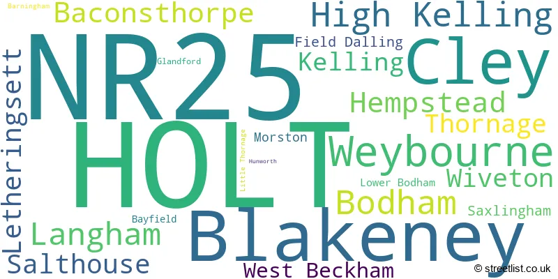
The largest settlement in the NR25 postal code is HOLT followed by Blakeney, and Weybourne.
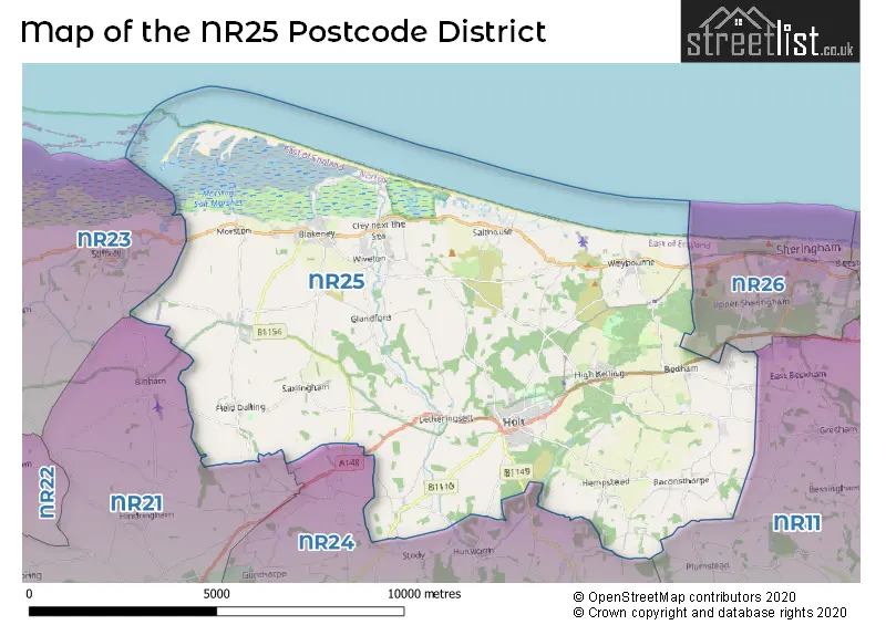
The postcode area has a boundary with The North Sea.
The NR25 Postcode shares a border with NR21 (FAKENHAM, Sculthorpe, South Creake), NR26 (SHERINGHAM, Beeston Regis, Upper Sheringham), NR24 (Briston, MELTON CONSTABLE, Edgefield) and NR11 (Aylsham, Mundesley, Southrepps).
In the NR25 postcode district in Norfolk, the primary settlement is Holt with a count of 183. Other significant settlements in the same district include Baconsthorpe, Barningham, Bodham, Hempstead, High Kelling, Letheringsett, Lower Bodham, and West Beckham. The most significant post town in the district is Holt, also located in Norfolk, England.
For the district NR25, we have data on 3 postcode sectors. Here's a breakdown: The sector NR25 6, covers Holt in Norfolk. The sector NR25 7, covers Blakeney and Cley and Weybourne in Norfolk. The sector NR25 9 is non-geographic. It's often designated for PO Boxes, large organisations, or special services.

Map of the NR25 Postcode District
Explore the NR25 postcode district by using our free interactive map.
When it comes to local government, postal geography often disregards political borders. However, for a breakdown in the NR25 District: the district mostly encompasses the North Norfolk District area with a total of 532 postcodes.
Recent House Sales in NR25
| Date | Price | Address |
|---|---|---|
| 24/10/2023 | £235,000 | The Beeches, Holt, NR25 6AU |
| 06/10/2023 | £324,350 | Langham Road, Blakeney, Holt, NR25 7PJ |
| 28/09/2023 | £305,000 | Blackthorn Avenue, Holt, NR25 6TY |
| 22/09/2023 | £221,500 | Howson Avenue, Holt, NR25 6FS |
| 22/09/2023 | £436,000 | Robin Close, Holt, NR25 6GD |
| 18/09/2023 | £350,000 | Glaven Hale Close, Holt, NR25 6FA |
| 31/08/2023 | £265,000 | Hempstead Road, Holt, NR25 6DQ |
| 29/08/2023 | £425,000 | Winns Close, Holt, NR25 6NQ |
| 23/08/2023 | £470,000 | Howson Avenue, Holt, NR25 6FS |
| 16/08/2023 | £350,000 | The Street, Morston, Holt, NR25 7AA |
Weather Forecast for NR25
Press Button to Show Forecast for Holt
| Time Period | Icon | Description | Temperature | Rain Probability | Wind |
|---|---|---|---|---|---|
| 03:00 to 06:00 | Partly cloudy (night) | 5.0°C (feels like 3.0°C) | 2.00% | ENE 7 mph | |
| 06:00 to 09:00 | Cloudy | 7.0°C (feels like 4.0°C) | 9.00% | ENE 7 mph | |
| 09:00 to 12:00 | Overcast | 8.0°C (feels like 5.0°C) | 21.00% | ENE 11 mph | |
| 12:00 to 15:00 | Overcast | 8.0°C (feels like 5.0°C) | 19.00% | ENE 13 mph | |
| 15:00 to 18:00 | Overcast | 8.0°C (feels like 4.0°C) | 17.00% | ENE 13 mph | |
| 18:00 to 21:00 | Overcast | 8.0°C (feels like 4.0°C) | 43.00% | NE 13 mph | |
| 21:00 to 00:00 | Overcast | 8.0°C (feels like 4.0°C) | 49.00% | NE 11 mph |
Press Button to Show Forecast for Holt
| Time Period | Icon | Description | Temperature | Rain Probability | Wind |
|---|---|---|---|---|---|
| 00:00 to 03:00 | Heavy rain | 8.0°C (feels like 4.0°C) | 88.00% | NE 13 mph | |
| 03:00 to 06:00 | Heavy rain | 8.0°C (feels like 5.0°C) | 91.00% | NE 13 mph | |
| 06:00 to 09:00 | Heavy rain | 9.0°C (feels like 7.0°C) | 79.00% | E 11 mph | |
| 09:00 to 12:00 | Heavy rain | 11.0°C (feels like 8.0°C) | 85.00% | W 13 mph | |
| 12:00 to 15:00 | Heavy rain | 10.0°C (feels like 7.0°C) | 83.00% | W 16 mph | |
| 15:00 to 18:00 | Light rain | 9.0°C (feels like 5.0°C) | 56.00% | W 13 mph | |
| 18:00 to 21:00 | Cloudy | 8.0°C (feels like 6.0°C) | 10.00% | WSW 9 mph | |
| 21:00 to 00:00 | Partly cloudy (night) | 7.0°C (feels like 4.0°C) | 3.00% | SW 9 mph |
Press Button to Show Forecast for Holt
| Time Period | Icon | Description | Temperature | Rain Probability | Wind |
|---|---|---|---|---|---|
| 00:00 to 03:00 | Partly cloudy (night) | 6.0°C (feels like 3.0°C) | 1.00% | SSW 9 mph | |
| 03:00 to 06:00 | Clear night | 5.0°C (feels like 2.0°C) | 1.00% | SSW 9 mph | |
| 06:00 to 09:00 | Sunny day | 6.0°C (feels like 3.0°C) | 1.00% | S 9 mph | |
| 09:00 to 12:00 | Sunny day | 11.0°C (feels like 9.0°C) | 0.00% | S 11 mph | |
| 12:00 to 15:00 | Cloudy | 13.0°C (feels like 11.0°C) | 6.00% | S 11 mph | |
| 15:00 to 18:00 | Partly cloudy (day) | 13.0°C (feels like 11.0°C) | 3.00% | S 13 mph | |
| 18:00 to 21:00 | Sunny day | 12.0°C (feels like 10.0°C) | 1.00% | SE 11 mph | |
| 21:00 to 00:00 | Clear night | 9.0°C (feels like 6.0°C) | 0.00% | SE 11 mph |
Press Button to Show Forecast for Holt
| Time Period | Icon | Description | Temperature | Rain Probability | Wind |
|---|---|---|---|---|---|
| 00:00 to 03:00 | Clear night | 8.0°C (feels like 5.0°C) | 2.00% | SE 9 mph | |
| 03:00 to 06:00 | Mist | 7.0°C (feels like 5.0°C) | 16.00% | SE 7 mph | |
| 06:00 to 09:00 | Cloudy | 9.0°C (feels like 7.0°C) | 7.00% | ESE 9 mph | |
| 09:00 to 12:00 | Overcast | 12.0°C (feels like 11.0°C) | 12.00% | E 9 mph | |
| 12:00 to 15:00 | Cloudy | 14.0°C (feels like 12.0°C) | 9.00% | ESE 9 mph | |
| 15:00 to 18:00 | Cloudy | 14.0°C (feels like 12.0°C) | 15.00% | ESE 11 mph | |
| 18:00 to 21:00 | Cloudy | 13.0°C (feels like 11.0°C) | 14.00% | ESE 11 mph | |
| 21:00 to 00:00 | Cloudy | 11.0°C (feels like 9.0°C) | 10.00% | E 9 mph |
Where is the NR25 Postcode District?
The postcode district NR25 is located in Holt, which is a town in Norfolk. Holt is surrounded by several nearby towns, with Melton Constable to the south, Sheringham to the east, Walsingham to the west, Fakenham to the southwest, and North Walsham to the southeast. Additionally, the distance from Holt to the center of London is approximately 110.27 miles.
The district is within the post town of HOLT.
The sector has postcodes within the nation of England.
The NR25 Postcode District is in the North and West Norfolk region of East Anglia within the East of England.
| Postcode Sector | Delivery Office |
|---|---|
| NR25 6 | Holt Delivery Office |
| NR25 7 | Holt Delivery Office |
| N | R | 2 | 5 | - | X | X | X |
| N | R | 2 | 5 | Space | Numeric | Letter | Letter |
Tourist Attractions within the Postcode Area
We found 1 visitor attractions within the NR25 postcode area
| The Muckleburgh Collection |
|---|
| Museums & Art Galleries |
| Museum and / or Art Gallery |
| View The Muckleburgh Collection on Google Maps |
Current Monthly Rental Prices
| # Bedrooms | Min Price | Max Price | Avg Price |
|---|---|---|---|
| 2 | £1,000 | £1,000 | £1,000 |
| 4 | £1,700 | £1,700 | £1,700 |
Current House Prices
| # Bedrooms | Min Price | Max Price | Avg Price |
|---|---|---|---|
| £300,000 | £795,000 | £479,000 | |
| 1 | £105,000 | £460,000 | £205,000 |
| 2 | £170,000 | £535,000 | £335,561 |
| 3 | £160,000 | £795,000 | £458,043 |
| 4 | £440,000 | £1,595,000 | £724,722 |
| 5 | £475,000 | £2,000,000 | £1,159,000 |
| 6 | £2,395,000 | £2,395,000 | £2,395,000 |
Estate Agents who Operate in the NR25 District
| Logo | Name | Brand Name | Address | Contact Number | Total Properties |
|---|---|---|---|---|---|
 | Holt | Sowerbys | 1 Market Place Holt NR25 6BE | 01263 801124 | 30 |
 | Holt | William H. Brown | The Old Fire Station, Albert Street, Holt, NR25 6HX | 01263 801363 | 17 |
 | Sheringham | Watsons | 58 Station Road, Sheringham, NR26 8RG | 01603 361981 | 11 |
 | Holt | Pointens | 18 High Street, Holt, NR25 6BH | 01263 801101 | 10 |
 | Holt | Brown & Co | 1a Market Place Holt NR25 6BE | 01263 801102 | 9 |
| Type of Property | 2018 Average | 2018 Sales | 2017 Average | 2017 Sales | 2016 Average | 2016 Sales | 2015 Average | 2015 Sales |
|---|---|---|---|---|---|---|---|---|
| Detached | £449,137 | 130 | £458,484 | 153 | £442,029 | 132 | £437,923 | 122 |
| Semi-Detached | £289,115 | 61 | £315,707 | 54 | £266,532 | 30 | £274,689 | 47 |
| Terraced | £296,242 | 68 | £362,011 | 51 | £323,392 | 39 | £309,525 | 67 |
| Flats | £211,416 | 12 | £160,333 | 3 | £168,242 | 6 | £178,983 | 20 |