The NR21 postcode district is a postal district located in the NR Norwich postcode area with a population of 16,472 residents according to the 2021 England and Wales Census.
The area of the NR21 postcode district is 82.23 square miles which is 212.97 square kilometres or 52,625.71 acres.
Currently, the NR21 district has about 802 postcode units spread across 4 geographic postcode sectors.
Given that each sector allows for 400 unique postcode combinations, the district has a capacity of 1,600 postcodes. With 802 postcodes already in use, this leaves 798 units available.
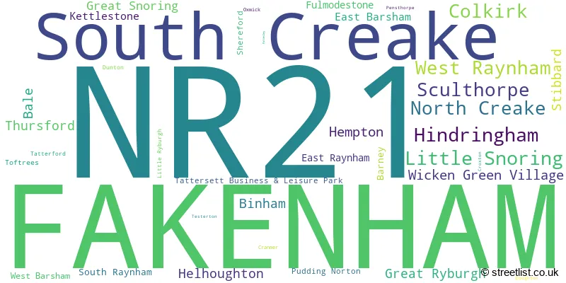
The largest settlement in the NR21 postal code is FAKENHAM followed by Sculthorpe, and South Creake.
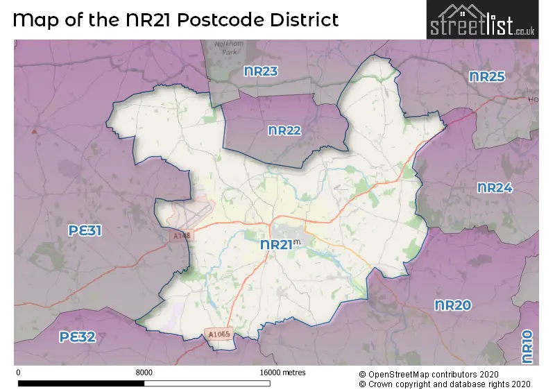
The NR21 Postcode shares a border with PE32 (Gayton, Narborough, Sporle), NR22 (WALSINGHAM, Egmere, Houghton St. Giles), NR23 (WELLS-NEXT-THE-SEA, Stiffkey, Wighton), NR25 (HOLT, Blakeney, Weybourne), PE31 (Heacham, Dersingham, Snettisham), NR20 (DEREHAM, Mattishall, Swanton Morley) and NR24 (Briston, MELTON CONSTABLE, Edgefield).
The primary settlement in the NR21 postcode district is Fakenham, located in the county of Norfolk, England. Other significant settlements in the district include Bale, Barney, Binham, Croxton, East Barsham, Fulmodestone, Great Ryburgh, Great Snoring, Hindringham, Kettlestone, Little Ryburgh, Little Snoring, Pensthorpe, Stibbard, and Thursford. The most significant post town in the district is also Fakenham.
For the district NR21, we have data on 5 postcode sectors. Here's a breakdown: The sector NR21 0, covers Little Snoring and Hindringham in Norfolk. The sector NR21 1 is non-geographic. It's often designated for PO Boxes, large organisations, or special services. The sector NR21 7, covers Colkirk and West Raynham and Hempton and Wicken Green Village in Norfolk. The sector NR21 8, covers Fakenham in Norfolk. The sector NR21 9, covers Fakenham and South Creake and North Creake and Sculthorpe in Norfolk.

Map of the NR21 Postcode District
Explore the NR21 postcode district by using our free interactive map.
When it comes to local government, postal geography often disregards political borders. However, for a breakdown in the NR21 District: the district mostly encompasses the North Norfolk District (717 postcodes), followed by the King's Lynn and West Norfolk District (B) area (57 postcodes), and finally, the Breckland District area (33 postcodes).
Recent House Sales in NR21
| Date | Price | Address |
|---|---|---|
| 27/10/2023 | £217,000 | Norwich Road, Fakenham, NR21 8AZ |
| 13/10/2023 | £270,000 | Valley Way, Fakenham, NR21 8PH |
| 13/10/2023 | £405,000 | Shereford Road, Hempton, Fakenham, NR21 7LJ |
| 06/10/2023 | £488,000 | The Street, Hindringham, Fakenham, NR21 0AA |
| 06/10/2023 | £142,000 | Fayregreen, Fakenham, NR21 8HE |
| 04/10/2023 | £217,000 | Raynham Way, West Raynham, Fakenham, NR21 7JT |
| 02/10/2023 | £426,000 | Buttlands Close, Binham, Fakenham, NR21 0DR |
| 29/09/2023 | £165,000 | Fayregreen, Fakenham, NR21 8HE |
| 26/09/2023 | £215,000 | Lancaster Avenue, Fakenham, NR21 8DJ |
| 21/09/2023 | £730,000 | Fakenham Road, Great Snoring, Fakenham, NR21 0HG |
Where is the NR21 Postcode District?
The postcode district NR21 is located in Fakenham, a town in Norfolk. Fakenham is surrounded by several nearby towns. To the North, there is Walsingham, which is approximately 3.5 miles away. To the East, there is Melton Constable, around 7.3 miles away. Going further Northeast, you will find Holt, which is approximately 10.9 miles away. To the South, there is Dereham, which is around 12.1 miles away. In the North West direction, there is King's Lynn, approximately 12.3 miles away. Heading West, you will come across Sandringham, which is about 14.4 miles away. Lastly, in the South West direction, there is Swaffham, which is approximately 15.6 miles away. Additionally, the distance between Fakenham and London is approximately 101.6 miles.
The district is within the post town of FAKENHAM.
The sector has postcodes within the nation of England.
The NR21 Postcode District is covers the following regions.
- North and West Norfolk - East Anglia - East of England
- Breckland and South Norfolk - East Anglia - East of England
Weather Forecast for NR21
Press Button to Show Forecast for Thursford
| Time Period | Icon | Description | Temperature | Rain Probability | Wind |
|---|---|---|---|---|---|
| 15:00 to 18:00 | Light rain | 17.0°C (feels like 15.0°C) | 45.00% | S 9 mph | |
| 18:00 to 21:00 | Light rain | 15.0°C (feels like 14.0°C) | 43.00% | S 9 mph | |
| 21:00 to 00:00 | Cloudy | 13.0°C (feels like 12.0°C) | 10.00% | SSE 7 mph |
Press Button to Show Forecast for Thursford
| Time Period | Icon | Description | Temperature | Rain Probability | Wind |
|---|---|---|---|---|---|
| 00:00 to 03:00 | Cloudy | 12.0°C (feels like 11.0°C) | 12.00% | SE 7 mph | |
| 03:00 to 06:00 | Cloudy | 12.0°C (feels like 11.0°C) | 17.00% | SE 4 mph | |
| 06:00 to 09:00 | Light rain | 12.0°C (feels like 12.0°C) | 56.00% | E 4 mph | |
| 09:00 to 12:00 | Light rain | 14.0°C (feels like 13.0°C) | 48.00% | ENE 4 mph | |
| 12:00 to 15:00 | Cloudy | 15.0°C (feels like 15.0°C) | 12.00% | E 4 mph | |
| 15:00 to 18:00 | Cloudy | 16.0°C (feels like 15.0°C) | 7.00% | ESE 7 mph | |
| 18:00 to 21:00 | Cloudy | 15.0°C (feels like 15.0°C) | 27.00% | WSW 4 mph | |
| 21:00 to 00:00 | Cloudy | 12.0°C (feels like 12.0°C) | 53.00% | WSW 4 mph |
Press Button to Show Forecast for Thursford
| Time Period | Icon | Description | Temperature | Rain Probability | Wind |
|---|---|---|---|---|---|
| 00:00 to 03:00 | Cloudy | 11.0°C (feels like 11.0°C) | 25.00% | WSW 4 mph | |
| 03:00 to 06:00 | Cloudy | 11.0°C (feels like 10.0°C) | 11.00% | SW 4 mph | |
| 06:00 to 09:00 | Cloudy | 11.0°C (feels like 11.0°C) | 13.00% | WSW 4 mph | |
| 09:00 to 12:00 | Cloudy | 15.0°C (feels like 15.0°C) | 11.00% | NW 4 mph | |
| 12:00 to 15:00 | Cloudy | 16.0°C (feels like 16.0°C) | 15.00% | N 7 mph | |
| 15:00 to 18:00 | Light rain shower (day) | 16.0°C (feels like 15.0°C) | 32.00% | N 7 mph | |
| 18:00 to 21:00 | Cloudy | 15.0°C (feels like 15.0°C) | 14.00% | NNE 7 mph | |
| 21:00 to 00:00 | Cloudy | 13.0°C (feels like 12.0°C) | 11.00% | NNE 4 mph |
Press Button to Show Forecast for Thursford
| Time Period | Icon | Description | Temperature | Rain Probability | Wind |
|---|---|---|---|---|---|
| 00:00 to 03:00 | Cloudy | 12.0°C (feels like 11.0°C) | 13.00% | NW 7 mph | |
| 03:00 to 06:00 | Partly cloudy (night) | 11.0°C (feels like 10.0°C) | 11.00% | NNW 7 mph | |
| 06:00 to 09:00 | Partly cloudy (day) | 12.0°C (feels like 11.0°C) | 8.00% | NW 7 mph | |
| 09:00 to 12:00 | Cloudy | 16.0°C (feels like 15.0°C) | 12.00% | E 7 mph | |
| 12:00 to 15:00 | Cloudy | 17.0°C (feels like 16.0°C) | 16.00% | NW 7 mph | |
| 15:00 to 18:00 | Light rain shower (day) | 17.0°C (feels like 16.0°C) | 32.00% | NE 7 mph | |
| 18:00 to 21:00 | Cloudy | 16.0°C (feels like 15.0°C) | 14.00% | NE 7 mph | |
| 21:00 to 00:00 | Partly cloudy (night) | 12.0°C (feels like 11.0°C) | 5.00% | NE 7 mph |
Press Button to Show Forecast for Thursford
| Time Period | Icon | Description | Temperature | Rain Probability | Wind |
|---|---|---|---|---|---|
| 00:00 to 03:00 | Cloudy | 11.0°C (feels like 10.0°C) | 13.00% | NE 7 mph | |
| 03:00 to 06:00 | Cloudy | 11.0°C (feels like 10.0°C) | 13.00% | NE 7 mph | |
| 06:00 to 09:00 | Cloudy | 12.0°C (feels like 11.0°C) | 13.00% | NE 9 mph | |
| 09:00 to 12:00 | Light rain | 15.0°C (feels like 13.0°C) | 44.00% | NNE 9 mph | |
| 12:00 to 15:00 | Cloudy | 16.0°C (feels like 15.0°C) | 15.00% | NNE 11 mph | |
| 15:00 to 18:00 | Partly cloudy (day) | 17.0°C (feels like 15.0°C) | 13.00% | NE 11 mph | |
| 18:00 to 21:00 | Sunny day | 15.0°C (feels like 13.0°C) | 6.00% | NE 11 mph | |
| 21:00 to 00:00 | Clear night | 12.0°C (feels like 10.0°C) | 3.00% | NNE 9 mph |
| Postcode Sector | Delivery Office |
|---|---|
| NR21 0 | Fakenham Delivery Office |
| NR21 7 | Fakenham Delivery Office |
| NR21 8 | Fakenham Delivery Office |
| NR21 9 | Fakenham Delivery Office |
| N | R | 2 | 1 | - | X | X | X |
| N | R | 2 | 1 | Space | Numeric | Letter | Letter |
Current Monthly Rental Prices
| # Bedrooms | Min Price | Max Price | Avg Price |
|---|---|---|---|
| 1 | £675 | £675 | £675 |
| 2 | £900 | £1,400 | £1,100 |
| 3 | £950 | £995 | £965 |
| 4 | £1,225 | £2,500 | £1,792 |
Current House Prices
| # Bedrooms | Min Price | Max Price | Avg Price |
|---|---|---|---|
| £40,000 | £3,345,000 | £815,833 | |
| 1 | £100,000 | £295,000 | £163,636 |
| 2 | £75,000 | £510,000 | £243,500 |
| 3 | £125,000 | £850,000 | £343,804 |
| 4 | £275,000 | £1,045,000 | £520,305 |
| 5 | £475,000 | £975,000 | £599,375 |
| 6 | £425,000 | £695,000 | £605,000 |
| 7 | £2,850,000 | £2,850,000 | £2,850,000 |
Estate Agents who Operate in the NR21 District
| Logo | Name | Brand Name | Address | Contact Number | Total Properties |
|---|---|---|---|---|---|
 | Fakenham | William H. Brown | Royal Oak House, 18 Oak Street, Fakenham, NR21 9DY | 01328 800703 | 44 |
 | Fakenham | Sowerbys | The Old Rectory, 21 Oak Street, Fakenham, NR21 9DX | 01328 800906 | 22 |
 | Fakenham | Bailey Bird & Warren | 39 Bridge Street, Fakenham, NR21 9AG | 01328 803447 | 20 |
 | Fakenham | Belton Duffey | 3 Market Place, Fakenham, NR21 9AS | 01328 800722 | 20 |
 | Fakenham | The Norfolk Agents | Marston & Langinger House, 13 George Edwards Road, Fakenham, NR21 8NL | 01328 862395 | 14 |
- Bale
- Barney
- Binham
- Colkirk
- Dunton
- East Barsham
- East Raynham
- Fakenham
- Fulmodeston
- Great Ryburgh
- Great Snoring
- Hamrow
- Helhoughton
- Hempton
- Hindringham
- Horningtoft
- Kettlestone
- Little Ryburgh
- Little Snoring
- North Creake
- Pudding Norton
- Sculthorpe
- South Creake
- South Raynham
- Stibbard
- Tatterford
- Thursford
- Thursford Green
- Waterden
- Weasenham St Peter
- West Barsham
- West Raynham
- Wicken Green Village
Yearly House Price Averages for the NR21 Postcode District
| Type of Property | 2018 Average | 2018 Sales | 2017 Average | 2017 Sales | 2016 Average | 2016 Sales | 2015 Average | 2015 Sales |
|---|---|---|---|---|---|---|---|---|
| Detached | £368,596 | 98 | £318,420 | 138 | £310,272 | 173 | £302,134 | 138 |
| Semi-Detached | £218,444 | 114 | £204,480 | 111 | £191,448 | 107 | £181,393 | 122 |
| Terraced | £196,112 | 65 | £188,907 | 70 | £192,348 | 92 | £172,057 | 97 |
| Flats | £140,932 | 22 | £124,532 | 14 | £113,667 | 12 | £120,647 | 16 |