
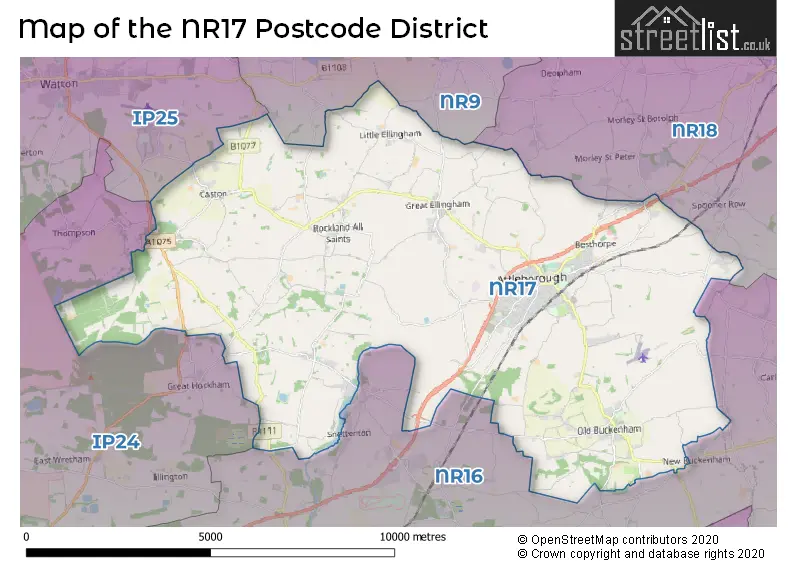
Map of the Postcode District
Explore the postcode district by using our interactive map.
Circles represent recorded crime; the larger the circle, the higher the crime rates.
Your support helps keep this site running!
If you enjoy using this website, consider buying me a coffee to help cover hosting costs.
The postcode district located in the NR Norwich postal area , NR17 has a population of 17,957 residents according to the 2021 England and Wales Census.
The area of the district is 44.36 square miles (114.89 square kilometers or 28,389.36 acres).
Where is the NR17 District?
To give you an idea where the district is located we have created the following table showing nearby towns.
Nearest Towns to NR17
| Town | Distance (miles) | Direction |
|---|---|---|
| Hingham | 4.51 | N |
| Wymondham | 7.12 | ENE |
| Watton | 7.21 | WNW |
| Diss | 11.23 | SSE |
| Dereham | 11.59 | N |
| Thetford | 11.64 | SW |
| Swaffham | 15.02 | NW |
| Brandon | 15.31 | WSW |
| Eye | 15.37 | SSE |
| Norwich | 15.72 | ENE |
| Harleston | 15.96 | ESE |
| Reepham | 18.08 | NNE |
| Bungay | 20.14 | ESE |
| Bury St Edmunds | 21.53 | SSW |
| Loddon | 21.61 | E |
| Fakenham | 22.37 | NNW |
| Stowmarket | 22.60 | S |
| Aylsham | 22.66 | NNE |
| Mildenhall | 22.72 | WSW |
The post town for this district is ATTLEBOROUGH.
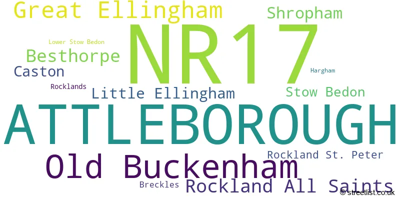
Postcode Information for District NR17 (Total Geographical Postcodes: 568)
| Location | Post Town | Sector | Number of Postcodes |
|---|---|---|---|
| ATTLEBOROUGH | ATTLEBOROUGH | NR17 2 | 212 |
| ATTLEBOROUGH | ATTLEBOROUGH | NR17 1 | 108 |
| Old Buckenham | ATTLEBOROUGH | NR17 1 | 62 |
| Great Ellingham | ATTLEBOROUGH | NR17 1 | 45 |
| Rockland All Saints | ATTLEBOROUGH | NR17 1 | 28 |
| Besthorpe | ATTLEBOROUGH | NR17 2 | 25 |
| Shropham | ATTLEBOROUGH | NR17 1 | 20 |
| Caston | ATTLEBOROUGH | NR17 1 | 18 |
| Little Ellingham | ATTLEBOROUGH | NR17 1 | 17 |
| Stow Bedon | ATTLEBOROUGH | NR17 1 | 13 |
| Rockland St. Peter | ATTLEBOROUGH | NR17 1 | 8 |
| Breckles | ATTLEBOROUGH | NR17 1 | 4 |
| Rocklands | ATTLEBOROUGH | NR17 1 | 3 |
| Lower Stow Bedon | ATTLEBOROUGH | NR17 1 | 2 |
| Hargham | ATTLEBOROUGH | NR17 1 | 2 |
| Besthorpe | ATTLEBOROUGH | NR17 1 | 1 |
Retail and Shopping in NR17
Street
Town
Locality
Number of Shops
Central Postcode
View on Google Maps
EXCHANGE STREET
ATTLEBOROUGH
24
NR17 2AB
View on Google Maps
CHURCH STREET
ATTLEBOROUGH
23
NR17 2AH
View on Google Maps
QUEENS SQUARE
ATTLEBOROUGH
19
NR17 2AF
View on Google Maps
CONNAUGHT PLAIN
ATTLEBOROUGH
8
NR17 2EJ
View on Google Maps
HIGH STREET
ATTLEBOROUGH
8
NR17 2BS
View on Google Maps
| Street | Town | Locality | Number of Shops | Central Postcode | View on Google Maps |
|---|---|---|---|---|---|
| EXCHANGE STREET | ATTLEBOROUGH | 24 | NR17 2AB | View on Google Maps | |
| CHURCH STREET | ATTLEBOROUGH | 23 | NR17 2AH | View on Google Maps | |
| QUEENS SQUARE | ATTLEBOROUGH | 19 | NR17 2AF | View on Google Maps | |
| CONNAUGHT PLAIN | ATTLEBOROUGH | 8 | NR17 2EJ | View on Google Maps | |
| HIGH STREET | ATTLEBOROUGH | 8 | NR17 2BS | View on Google Maps |
The primary settlement in the NR17 postcode district is Attleborough, located in the county of Norfolk in England. Other significant settlements in the district include Besthorpe, Breckles, Caston, Great Ellingham, Hargham, Little Ellingham, Lower Stow Bedon, Old Buckenham, Rockland All Saints, Rockland St. Peter, Rocklands, Shropham, and Stow Bedon. The most significant post town in the district is Attleborough.
When it comes to local government, postal geography often disregards political borders. However, this district intersects the following councils: the district mostly encompasses the Breckland District area with a total of 573 postal codes.
The largest settlement in the NR17 postal code is ATTLEBOROUGH followed by Old Buckenham, and Great Ellingham.
The NR17 Postcode shares a border with IP24 (THETFORD, Great Hockham, Elveden), NR9 (Hethersett, Hingham, Easton), NR16 (East Harling, Banham, Bunwell) and NR18 (WYMONDHAM, Wicklewood, Deopham).


Schools in the Sector
Ellingham Hospital School
Phase: Not applicable
Address: Ellingham Road , Attleborough
Postcode: NR17 1AE
Headteacher: Mrs Ursula Castillo ()
Ofsted Rating: Good
Rosecroft Primary School
Phase: Primary
Address: London Road , Attleborough
Postcode: NR17 1BE
Headteacher: Mrs Gayle Long (Headteacher)
Ofsted Rating: Good
Caston Church of England Voluntary Aided Primary School
Phase: Primary
Address: The Street , Caston , Caston Primary School , Attleborough
Postcode: NR17 1DD
Headteacher: Mrs Sarah Disney (Headteacher)
Ofsted Rating: Good
Caston Church of England Primary Academy
Phase: Primary
Address: The Street , Caston , Attleborough
Postcode: NR17 1DD
Headteacher: Mrs Sarah Disney ()
Ofsted Rating: Good
Great Ellingham Primary School
Phase: Primary
Address: Hingham Road , Great Ellingham , Attleborough
Postcode: NR17 1HX
Headteacher: Mrs Julie Dekker (Executive Headteacher)
Ofsted Rating: Good
Chapel Green School
Phase: Not applicable
Address: Attleborough Road , Old Buckenham
Postcode: NR17 1RF
Headteacher: Mrs Emily Severn (Headteacher)
Ofsted Rating: Good
Old Buckenham Community Primary School
Phase: Primary
Address: Abbey Road , Old Buckenham , Attleborough
Postcode: NR17 1RH
Headteacher: Ms Julia Humphrey (Headteacher)
Ofsted Rating: Good
Old Buckenham Primary School and Nursery
Phase: Primary
Address: Abbey Road , Old Buckenham , Attleborough
Postcode: NR17 1RH
Headteacher: Mrs Helen Mitchell ()
Ofsted Rating: Good
Old Buckenham High School
Phase: Secondary
Address: Abbey Road , Old Buckenham , Attleborough
Postcode: NR17 1RL
Headteacher: Mr Andrew Fell (Headteacher)
Ofsted Rating: Good
Old Buckenham High School
Phase: Secondary
Address: Abbey Road , Old Buckenham , Attleborough
Postcode: NR17 1RL
Headteacher: Mrs Claire Elliott (Headteacher)
Ofsted Rating: Good
Rocklands Community Primary School
Phase: Primary
Address: 74 The Street , Rockland All Saints , Attleborough
Postcode: NR17 1TP
Headteacher: Mrs Julie Dekker (Headteacher)
Ofsted Rating: Good
Attleborough Academy
Phase: Secondary
Address: 9 Norwich Road , Attleborough
Postcode: NR17 2AJ
Headteacher: Mr Neil McShane (Principal)
Ofsted Rating: Good
Attleborough Primary School
Phase: Primary
Address: Besthorpe Road , Attleborough
Postcode: NR17 2NA
Headteacher: Mrs Gayle Long (Headteacher)
Ofsted Rating: Requires improvement
Stations in the Sector
Attleborough
CRS Code: ATL
Operator: LE
Line: Breckland line
Company: Greater Anglia
Accessable Motorway Junctions
No Motorway Junctions Accessable from this postcode district.
Weather Forecast for Great Ellingham
| Time Period | Icon | Description | Temperature | Rain Probability | Wind |
|---|---|---|---|---|---|
| 12:00 to 15:00 | Cloudy | 14.0°C (feels like 12.0°C) | 5.00% | WSW 13 mph | |
| 15:00 to 18:00 | Cloudy | 14.0°C (feels like 13.0°C) | 5.00% | WSW 9 mph | |
| 18:00 to 21:00 | Clear night | 11.0°C (feels like 10.0°C) | 0.00% | SW 4 mph | |
| 21:00 to 00:00 | Clear night | 9.0°C (feels like 8.0°C) | 1.00% | SW 4 mph |
| Time Period | Icon | Description | Temperature | Rain Probability | Wind |
|---|---|---|---|---|---|
| 00:00 to 03:00 | Partly cloudy (night) | 8.0°C (feels like 7.0°C) | 4.00% | SSW 4 mph | |
| 03:00 to 06:00 | Fog | 7.0°C (feels like 6.0°C) | 17.00% | SSW 4 mph | |
| 06:00 to 09:00 | Fog | 7.0°C (feels like 6.0°C) | 17.00% | SSW 4 mph | |
| 09:00 to 12:00 | Fog | 10.0°C (feels like 8.0°C) | 15.00% | SSW 7 mph | |
| 12:00 to 15:00 | Cloudy | 13.0°C (feels like 12.0°C) | 3.00% | SSW 9 mph | |
| 15:00 to 18:00 | Partly cloudy (day) | 14.0°C (feels like 13.0°C) | 1.00% | S 7 mph | |
| 18:00 to 21:00 | Clear night | 12.0°C (feels like 10.0°C) | 0.00% | SSE 7 mph | |
| 21:00 to 00:00 | Clear night | 11.0°C (feels like 9.0°C) | 1.00% | SSE 7 mph |
| Time Period | Icon | Description | Temperature | Rain Probability | Wind |
|---|---|---|---|---|---|
| 00:00 to 03:00 | Clear night | 10.0°C (feels like 8.0°C) | 1.00% | SSE 9 mph | |
| 03:00 to 06:00 | Clear night | 10.0°C (feels like 8.0°C) | 0.00% | SSE 9 mph | |
| 06:00 to 09:00 | Clear night | 10.0°C (feels like 8.0°C) | 0.00% | SSE 9 mph | |
| 09:00 to 12:00 | Sunny day | 12.0°C (feels like 10.0°C) | 0.00% | SSE 11 mph | |
| 12:00 to 15:00 | Sunny day | 15.0°C (feels like 12.0°C) | 1.00% | SSE 13 mph | |
| 15:00 to 18:00 | Sunny day | 15.0°C (feels like 12.0°C) | 1.00% | SSE 11 mph | |
| 18:00 to 21:00 | Clear night | 12.0°C (feels like 10.0°C) | 2.00% | SSE 11 mph | |
| 21:00 to 00:00 | Partly cloudy (night) | 13.0°C (feels like 11.0°C) | 1.00% | SSE 11 mph |
| Time Period | Icon | Description | Temperature | Rain Probability | Wind |
|---|---|---|---|---|---|
| 00:00 to 03:00 | Partly cloudy (night) | 13.0°C (feels like 11.0°C) | 7.00% | S 11 mph | |
| 03:00 to 06:00 | Partly cloudy (night) | 13.0°C (feels like 11.0°C) | 15.00% | S 11 mph | |
| 06:00 to 09:00 | Partly cloudy (night) | 12.0°C (feels like 10.0°C) | 11.00% | SSW 11 mph | |
| 09:00 to 12:00 | Partly cloudy (day) | 13.0°C (feels like 11.0°C) | 6.00% | SSW 11 mph | |
| 12:00 to 15:00 | Partly cloudy (day) | 13.0°C (feels like 11.0°C) | 10.00% | SSW 11 mph | |
| 15:00 to 18:00 | Sunny day | 13.0°C (feels like 11.0°C) | 8.00% | SSW 11 mph | |
| 18:00 to 21:00 | Clear night | 11.0°C (feels like 8.0°C) | 4.00% | SSW 11 mph | |
| 21:00 to 00:00 | Clear night | 9.0°C (feels like 7.0°C) | 3.00% | SW 11 mph |
| Time Period | Icon | Description | Temperature | Rain Probability | Wind |
|---|---|---|---|---|---|
| 00:00 to 03:00 | Clear night | 8.0°C (feels like 6.0°C) | 2.00% | SW 11 mph | |
| 03:00 to 06:00 | Clear night | 8.0°C (feels like 5.0°C) | 2.00% | SW 11 mph | |
| 06:00 to 09:00 | Clear night | 8.0°C (feels like 5.0°C) | 6.00% | SSW 11 mph | |
| 09:00 to 12:00 | Partly cloudy (day) | 10.0°C (feels like 7.0°C) | 9.00% | SSW 11 mph | |
| 12:00 to 15:00 | Partly cloudy (day) | 12.0°C (feels like 9.0°C) | 8.00% | SW 16 mph | |
| 15:00 to 18:00 | Cloudy | 12.0°C (feels like 10.0°C) | 14.00% | SW 13 mph | |
| 18:00 to 21:00 | Partly cloudy (night) | 11.0°C (feels like 9.0°C) | 7.00% | SW 11 mph | |
| 21:00 to 00:00 | Cloudy | 11.0°C (feels like 8.0°C) | 11.00% | SW 11 mph |
| Postal Sector | Delivery Office |
|---|---|
| NR17 1 | Attleborough Scale Payment Delivery Office |
| NR17 2 | Attleborough Scale Payment Delivery Office |
| N | R | 1 | 7 | - | X | X | X |
| N | R | 1 | 7 | Space | Numeric | Letter | Letter |
Street List for the NR17 District
Current Monthly Rental Prices
| # Bedrooms | Min Price | Max Price | Avg Price |
|---|---|---|---|
| £3,375 | £3,375 | £3,375 | |
| 2 | £875 | £1,350 | £1,040 |
| 3 | £1,250 | £1,250 | £1,250 |
| 4 | £1,600 | £2,100 | £1,875 |
Current House Prices
| # Bedrooms | Min Price | Max Price | Avg Price |
|---|---|---|---|
| £250,000 | £2,500,000 | £867,857 | |
| 1 | £95,000 | £140,000 | £121,000 |
| 2 | £125,000 | £475,000 | £248,762 |
| 3 | £160,000 | £580,000 | £337,601 |
| 4 | £325,000 | £1,300,000 | £526,576 |
| 5 | £550,000 | £1,150,000 | £697,308 |
| 6 | £500,000 | £900,000 | £711,000 |
Estate Agents
| Logo | Name | Brand Name | Address | Contact Number |
|---|---|---|---|---|
 | Attleborough | Hammond & Stratford | Connaught Plain, Attleborough, NR17 2EJ | 01953 667597 |
 | Attleborough | Moneyproperties | Exchange Street, Attleborough, NR17 2AB | 01953 423006 |
 | Attleborough | Millbank Estate Agents | Wheatacre House Exchange Street Attleborough NR17 2AB | 01953 667630 |
 | Attleborough | William H. Brown | Exchange Street, Attleborough, NR17 2AB | 01953 667598 |
 | Attleborough | Abbotts | 20 Exchange Street, Attleborough, Norfolk, NR17 2AB | 01953 667596 |
- Anchor Corner
- Attleborough
- Baconsthorpe
- Besthorpe
- Black Carr
- Bow Street
- Carleton Rode
- Caston
- Fen Street
- Great Ellingham
- Great Hockham
- Little Ellingham
- Morley St Peter
- Northacre
- Old Buckenham
- Puddledock
- Rockland All Saints
- Rockland St Peter
- Shropham
- Snetterton Heath
- Snetterton
- Spooner Row
- Stalland Common
- Stow Bedon
- Thompson
Yearly House Price Averages for the District
| Type of Property | 2018 Average | 2018 Sales | 2017 Average | 2017 Sales | 2016 Average | 2016 Sales | 2015 Average | 2015 Sales |
|---|---|---|---|---|---|---|---|---|
| Detached | £340,179 | 170 | £326,081 | 165 | £302,162 | 225 | £284,966 | 252 |
| Semi-Detached | £229,227 | 80 | £207,906 | 102 | £197,618 | 84 | £188,829 | 99 |
| Terraced | £208,423 | 62 | £193,201 | 69 | £164,224 | 77 | £153,955 | 66 |
| Flats | £117,158 | 12 | £116,533 | 15 | £114,541 | 11 | £100,765 | 13 |