The NR17 2 postcode sector is within the county of Norfolk.
Did you know? According to the 2021 Census, the NR17 2 postcode sector is home to a bustling 8,990 residents!
Given that each sector allows for 400 unique postcode combinations. Letters C, I, K, M, O and V are not allowed in the last two letters of a postcode. With 227 postcodes already in use, this leaves 173 units available.
The largest settlements in the NR17 2 postal code are ATTLEBOROUGH and Besthorpe.
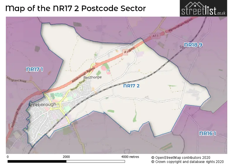
The NR17 2 Postcode shares a border with NR16 1 (Bunwell, Forncett St. Peter, Carleton Rode), NR17 1 (ATTLEBOROUGH, Old Buckenham, Great Ellingham) and NR18 9 (WYMONDHAM, Wicklewood, Deopham).
The sector is within the post town of ATTLEBOROUGH.
NR17 2 is a postcode sector within the NR17 postcode district which is within the NR Norwich postcode area.
The Royal Mail delivery office for the NR17 2 postal sector is the Attleborough Scale Payment Delivery Office.
The area of the NR17 2 postcode sector is 5.51 square miles which is 14.26 square kilometres or 3,523.65 square acres.
The NR17 2 postcode sector is crossed by the A11 Major A road.

Map of the NR17 2 Postcode Sector
Explore the NR17 2 postcode sector by using our free interactive map.
| N | R | 1 | 7 | - | 2 | X | X |
| N | R | 1 | 7 | Space | 2 | Letter | Letter |
Official List of Streets
ATTLEBOROUGH (140 Streets)
Besthorpe (10 Streets)
Unofficial Streets or Alternative Spellings
Carleton Rode
BESTHORPE ROADMorley St. Peter
ATTLEBOROUGH ROADDeopham
ATTLEBOROUGH ROADATTLEBOROUGH
BLACKTHORN ROAD BUCKENHAM ROAD DEOPHAM ROAD ELIZABETH CLOSE ELLISON CLOSE FLOWERS LANE GOLDFINCH DRIVE HIGH VIEW DRIVE NORFOLK DRIVE SPECKLED WOOD CLOSE WEST CARR ROADOld Buckenham
HARGHAM ROAD LEYS LANEHargham
LONDON ROADWeather Forecast for NR17 2
Press Button to Show Forecast for Attleborough
| Time Period | Icon | Description | Temperature | Rain Probability | Wind |
|---|---|---|---|---|---|
| 06:00 to 09:00 | Cloudy | 3.0°C (feels like 1.0°C) | 4.00% | NW 4 mph | |
| 09:00 to 12:00 | Cloudy | 8.0°C (feels like 7.0°C) | 5.00% | NE 4 mph | |
| 12:00 to 15:00 | Overcast | 10.0°C (feels like 9.0°C) | 10.00% | ENE 4 mph | |
| 15:00 to 18:00 | Cloudy | 9.0°C (feels like 8.0°C) | 10.00% | ENE 7 mph | |
| 18:00 to 21:00 | Cloudy | 8.0°C (feels like 6.0°C) | 8.00% | ENE 7 mph | |
| 21:00 to 00:00 | Cloudy | 5.0°C (feels like 3.0°C) | 7.00% | ENE 4 mph |
Press Button to Show Forecast for Attleborough
| Time Period | Icon | Description | Temperature | Rain Probability | Wind |
|---|---|---|---|---|---|
| 00:00 to 03:00 | Cloudy | 3.0°C (feels like 1.0°C) | 8.00% | NE 4 mph | |
| 03:00 to 06:00 | Partly cloudy (night) | 3.0°C (feels like 0.0°C) | 8.00% | NE 4 mph | |
| 06:00 to 09:00 | Cloudy | 5.0°C (feels like 2.0°C) | 12.00% | NE 7 mph | |
| 09:00 to 12:00 | Overcast | 9.0°C (feels like 7.0°C) | 21.00% | ENE 9 mph | |
| 12:00 to 15:00 | Overcast | 11.0°C (feels like 9.0°C) | 16.00% | E 9 mph | |
| 15:00 to 18:00 | Overcast | 12.0°C (feels like 9.0°C) | 15.00% | ENE 9 mph | |
| 18:00 to 21:00 | Cloudy | 10.0°C (feels like 8.0°C) | 12.00% | ENE 9 mph | |
| 21:00 to 00:00 | Cloudy | 8.0°C (feels like 6.0°C) | 19.00% | ENE 11 mph |
Press Button to Show Forecast for Attleborough
| Time Period | Icon | Description | Temperature | Rain Probability | Wind |
|---|---|---|---|---|---|
| 00:00 to 03:00 | Light rain | 9.0°C (feels like 6.0°C) | 51.00% | ENE 11 mph | |
| 03:00 to 06:00 | Heavy rain shower (night) | 9.0°C (feels like 7.0°C) | 56.00% | E 9 mph | |
| 06:00 to 09:00 | Light rain | 10.0°C (feels like 8.0°C) | 51.00% | SE 9 mph | |
| 09:00 to 12:00 | Light rain shower (day) | 12.0°C (feels like 9.0°C) | 38.00% | SSE 11 mph | |
| 12:00 to 15:00 | Light rain shower (day) | 13.0°C (feels like 10.0°C) | 45.00% | SSE 13 mph | |
| 15:00 to 18:00 | Heavy rain shower (day) | 13.0°C (feels like 10.0°C) | 56.00% | SW 13 mph | |
| 18:00 to 21:00 | Light rain shower (day) | 12.0°C (feels like 10.0°C) | 33.00% | SW 9 mph | |
| 21:00 to 00:00 | Partly cloudy (night) | 9.0°C (feels like 7.0°C) | 5.00% | SW 9 mph |
Schools and Places of Education Within the NR17 2 Postcode Sector
Attleborough Academy
Academy converter
9 Norwich Road, Attleborough, Norfolk, NR17 2AJ
Head: Mr Neil McShane
Ofsted Rating: Good
Inspection: 2021-12-08 (870 days ago)
Website: Visit Attleborough Academy Website
Phone: 01953452335
Number of Pupils: 884
Attleborough Primary School
Community school
Besthorpe Road, Attleborough, Norfolk, NR17 2NA
Head: Mrs Gayle Long
Ofsted Rating: Requires improvement
Inspection: 2022-03-02 (786 days ago)
Website: Visit Attleborough Primary School Website
Phone: 01953453491
Number of Pupils: 374
House Prices in the NR17 2 Postcode Sector
| Type of Property | 2018 Average | 2018 Sales | 2017 Average | 2017 Sales | 2016 Average | 2016 Sales | 2015 Average | 2015 Sales |
|---|---|---|---|---|---|---|---|---|
| Detached | £289,772 | 79 | £278,812 | 88 | £272,788 | 97 | £251,825 | 114 |
| Semi-Detached | £220,382 | 38 | £211,119 | 52 | £188,450 | 33 | £180,600 | 56 |
| Terraced | £193,675 | 20 | £179,548 | 30 | £155,553 | 51 | £149,176 | 35 |
| Flats | £113,290 | 10 | £114,583 | 12 | £114,541 | 11 | £99,545 | 11 |
Important Postcodes NR17 2 in the Postcode Sector
NR17 2AF is the postcode for Queens Square Surgery, Queens Square
NR17 2AH is the postcode for Attleborough Community & Enterprise Centre and Library, Church Street
NR17 2AJ is the postcode for MAIN BLOCK, Attleborough Academy Norfolk, 9 Norwich Road, MODERN LANGUAGES & HUMANITIES BLOCK, Attleborough Academy Norfolk, 9 Norwich Road, Attleborough Infant School, 7 Norwich Road, FOOD TECH BLOCK, Attleborough Academy Norfolk, 9 Norwich Road, SPORTS HALL BLOCK, Attleborough Academy Norfolk, 9 Norwich Road, SIXTH FORM BLOCK, Attleborough Academy Norfolk, 9 Norwich Road, ICT BLOCK, Attleborough Academy Norfolk, 9 Norwich Road, and ART & DRAMA BLOCK, Attleborough Academy Norfolk, 9 Norwich Road
NR17 2AS is the postcode for Attleborough Surgeries, Station Road, and Station Road
NR17 2AT is the postcode for Attleborough Community Hub, Station Road, and Norfolk County Council, Station Road
NR17 2AW is the postcode for St. Edmunds, Surrogate Street
NR17 2DS is the postcode for Chapel Road School, Chapel Road
NR17 2DW is the postcode for Norfolk Constabulary, Police Station, London Road
NR17 2NA is the postcode for Attleborough Primary School, 18-20 Besthorpe Road
| The NR17 2 Sector is within these Local Authorities |
|
|---|---|
| The NR17 2 Sector is within these Counties |
|
| The NR17 2 Sector is within these Water Company Areas |
|