The NR9 postcode district is a postal district located in the NR Norwich postcode area with a population of 19,369 residents according to the 2021 England and Wales Census.
The area of the NR9 postcode district is 72.82 square miles which is 188.61 square kilometres or 46,605.78 acres.
Currently, the NR9 district has about 668 postcode units spread across 3 geographic postcode sectors.
Given that each sector allows for 400 unique postcode combinations, the district has a capacity of 1,200 postcodes. With 668 postcodes already in use, this leaves 532 units available.
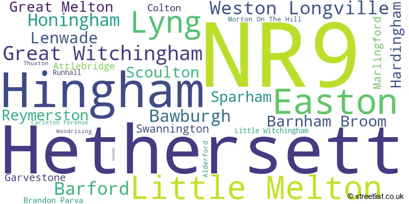
The largest settlement in the NR9 postal code is Hethersett followed by Hingham, and Easton.
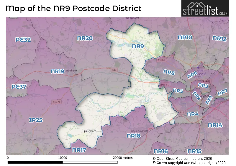
The NR9 Postcode shares a border with IP25 (Watton, Shipdham, Carbrooke), NR17 (ATTLEBOROUGH, Old Buckenham, Great Ellingham), NR19 (DEREHAM, Scarning, Yaxham), NR10 (Horsford, Spixworth, Reepham), NR4 (NORWICH, Cringleford, Colney), NR5 (NORWICH, New Costessey), NR8 (Taverham, Costessey, Drayton), NR18 (WYMONDHAM, Wicklewood, Deopham) and NR20 (DEREHAM, Mattishall, Swanton Morley).
The primary settlement in the NR9 postcode district is Hethersett. Other significant settlements in this district include Bawburgh, Great Melton, and Little Melton. The post town for this district is Norwich, located in the county of Norfolk.
For the district NR9, we have data on 3 postcode sectors. Here's a breakdown: The sector NR9 3, covers Hethersett and Little Melton in Norfolk. The sector NR9 4, covers Hingham and Barford in Norfolk. The sector NR9 5, covers Easton and Lyng and Great Witchingham in Norfolk.

Map of the NR9 Postcode District
Explore the NR9 postcode district by using our free interactive map.
When it comes to local government, postal geography often disregards political borders. However, for a breakdown in the NR9 District: the district mostly encompasses the South Norfolk District (461 postcodes), followed by the Broadland District area (124 postcodes), and finally, the Breckland District area (115 postcodes).
Recent House Sales in NR9
| Date | Price | Address |
|---|---|---|
| 23/10/2023 | £215,000 | Mill Road, Hethersett, Norwich, NR9 3DR |
| 09/10/2023 | £275,000 | Grove Road, Hethersett, Norwich, NR9 3JP |
| 22/09/2023 | £330,000 | Dereham Road, Easton, Norwich, NR9 5EH |
| 21/09/2023 | £345,000 | Admirals Way, Hethersett, Norwich, NR9 3AQ |
| 15/09/2023 | £420,000 | Horseshoe Road, Hethersett, Norwich, NR9 3PA |
| 15/09/2023 | £260,000 | Firs Road, Hethersett, Norwich, NR9 3EH |
| 08/09/2023 | £160,000 | Kendal Close, Hethersett, Norwich, NR9 3PW |
| 07/09/2023 | £176,000 | Kendal Close, Hethersett, Norwich, NR9 3PW |
| 04/09/2023 | £180,002 | Great Melton Road, Hethersett, Norwich, NR9 3AB |
| 01/09/2023 | £280,000 | Fakenham Road, Great Witchingham, Norwich, NR9 5AE |
Weather Forecast for NR9
Press Button to Show Forecast for Thuxton
| Time Period | Icon | Description | Temperature | Rain Probability | Wind |
|---|---|---|---|---|---|
| 03:00 to 06:00 | Cloudy | 4.0°C (feels like 2.0°C) | 7.00% | NE 7 mph | |
| 06:00 to 09:00 | Cloudy | 6.0°C (feels like 4.0°C) | 21.00% | NE 7 mph | |
| 09:00 to 12:00 | Light rain | 8.0°C (feels like 5.0°C) | 49.00% | ENE 9 mph | |
| 12:00 to 15:00 | Overcast | 9.0°C (feels like 6.0°C) | 20.00% | ENE 11 mph | |
| 15:00 to 18:00 | Overcast | 9.0°C (feels like 6.0°C) | 14.00% | NE 11 mph | |
| 18:00 to 21:00 | Overcast | 8.0°C (feels like 6.0°C) | 11.00% | NE 11 mph | |
| 21:00 to 00:00 | Light rain | 8.0°C (feels like 5.0°C) | 53.00% | NE 11 mph |
Press Button to Show Forecast for Thuxton
| Time Period | Icon | Description | Temperature | Rain Probability | Wind |
|---|---|---|---|---|---|
| 00:00 to 03:00 | Heavy rain | 8.0°C (feels like 5.0°C) | 89.00% | NE 11 mph | |
| 03:00 to 06:00 | Heavy rain | 9.0°C (feels like 6.0°C) | 91.00% | NE 9 mph | |
| 06:00 to 09:00 | Heavy rain | 9.0°C (feels like 7.0°C) | 78.00% | E 9 mph | |
| 09:00 to 12:00 | Light rain shower (day) | 11.0°C (feels like 8.0°C) | 52.00% | SW 11 mph | |
| 12:00 to 15:00 | Heavy rain shower (day) | 11.0°C (feels like 8.0°C) | 64.00% | W 11 mph | |
| 15:00 to 18:00 | Light rain | 9.0°C (feels like 6.0°C) | 56.00% | W 13 mph | |
| 18:00 to 21:00 | Cloudy | 9.0°C (feels like 7.0°C) | 10.00% | WSW 9 mph | |
| 21:00 to 00:00 | Cloudy | 7.0°C (feels like 5.0°C) | 5.00% | SW 7 mph |
Press Button to Show Forecast for Thuxton
| Time Period | Icon | Description | Temperature | Rain Probability | Wind |
|---|---|---|---|---|---|
| 00:00 to 03:00 | Clear night | 6.0°C (feels like 4.0°C) | 1.00% | SW 7 mph | |
| 03:00 to 06:00 | Clear night | 5.0°C (feels like 2.0°C) | 1.00% | SSW 7 mph | |
| 06:00 to 09:00 | Sunny day | 6.0°C (feels like 4.0°C) | 1.00% | S 7 mph | |
| 09:00 to 12:00 | Partly cloudy (day) | 11.0°C (feels like 9.0°C) | 1.00% | S 9 mph | |
| 12:00 to 15:00 | Partly cloudy (day) | 14.0°C (feels like 11.0°C) | 4.00% | S 11 mph | |
| 15:00 to 18:00 | Cloudy | 14.0°C (feels like 12.0°C) | 4.00% | S 11 mph | |
| 18:00 to 21:00 | Sunny day | 12.0°C (feels like 10.0°C) | 1.00% | SSE 9 mph | |
| 21:00 to 00:00 | Clear night | 9.0°C (feels like 7.0°C) | 1.00% | SE 7 mph |
Press Button to Show Forecast for Thuxton
| Time Period | Icon | Description | Temperature | Rain Probability | Wind |
|---|---|---|---|---|---|
| 00:00 to 03:00 | Clear night | 8.0°C (feels like 6.0°C) | 2.00% | SE 7 mph | |
| 03:00 to 06:00 | Clear night | 7.0°C (feels like 5.0°C) | 6.00% | ESE 7 mph | |
| 06:00 to 09:00 | Cloudy | 9.0°C (feels like 8.0°C) | 7.00% | E 7 mph | |
| 09:00 to 12:00 | Overcast | 13.0°C (feels like 12.0°C) | 12.00% | ESE 7 mph | |
| 12:00 to 15:00 | Cloudy | 15.0°C (feels like 13.0°C) | 11.00% | SE 9 mph | |
| 15:00 to 18:00 | Cloudy | 15.0°C (feels like 14.0°C) | 7.00% | SE 11 mph | |
| 18:00 to 21:00 | Cloudy | 14.0°C (feels like 13.0°C) | 7.00% | ESE 9 mph | |
| 21:00 to 00:00 | Cloudy | 11.0°C (feels like 10.0°C) | 11.00% | E 7 mph |
Where is the NR9 Postcode District?
The postcode district NR9 is located in Norwich, a town in Norfolk. This district is situated near several towns, including Wymondham to the south, Dereham to the northwest, Melton Constable to the north, Swaffham to the west, and North Walsham to the northeast. Additionally, NR9 is approximately 93.94 miles away from the center of London.
The district is within the post town of NORWICH.
The sector has postcodes within the nation of England.
The NR9 Postcode District is covers the following regions.
- Breckland and South Norfolk - East Anglia - East of England
- Norwich and East Norfolk - East Anglia - East of England
| Postcode Sector | Delivery Office |
|---|---|
| NR9 3 | Hethersett Scale Payment Delivery Office |
| NR9 3 | Wymondham Delivery Office |
| NR9 4 | Wymondham Delivery Office |
| NR9 5 | Wymondham Delivery Office |
| NR9 5 | Reepham Scale Payment Delivery Office |
| NR9 5 | Lyng Scale Payment Delivery Office |
| N | R | 9 | - | X | X | X |
| N | R | 9 | Space | Numeric | Letter | Letter |
Tourist Attractions within the Postcode Area
We found 1 visitor attractions within the NR9 postcode area
| Dinosaur Adventure |
|---|
| Leisure / Theme Parks |
| Leisure / Theme Park |
| View Dinosaur Adventure on Google Maps |
Current Monthly Rental Prices
| # Bedrooms | Min Price | Max Price | Avg Price |
|---|---|---|---|
| £475 | £600 | £558 | |
| 1 | £500 | £900 | £714 |
| 2 | £950 | £2,300 | £1,335 |
| 3 | £1,050 | £1,600 | £1,249 |
| 4 | £1,450 | £1,995 | £1,680 |
| 5 | £2,790 | £2,790 | £2,790 |
Current House Prices
| # Bedrooms | Min Price | Max Price | Avg Price |
|---|---|---|---|
| £1,200,000 | £1,200,000 | £1,200,000 | |
| 1 | £160,000 | £190,000 | £172,500 |
| 2 | £65,000 | £495,000 | £268,741 |
| 3 | £85,000 | £675,000 | £369,145 |
| 4 | £200,000 | £1,050,000 | £483,145 |
| 5 | £375,000 | £2,200,000 | £825,632 |
| 6 | £585,000 | £2,000,000 | £1,196,250 |
| 9 | £1,695,000 | £1,695,000 | £1,695,000 |
Estate Agents who Operate in the NR9 District
| Logo | Name | Brand Name | Address | Contact Number | Total Properties |
|---|---|---|---|---|---|
 | Hethersett | Hammond & Stratford | 28 Great Melton Road, Hethersett, NR9 3AB | 01603 361945 | 24 |
 | Wymondham | Warners Estate Agents | 13 Market Street, Wymondham, NR18 0AJ | 01953 667554 | 11 |
 | Wymondham | Abbotts | 15 Market Place Wymondham NR18 0AX | 01953 667631 | 10 |
 | Wymondham | Starkings & Watson | 46 Back Lane, Wymondham, NR18 0LB | 01953 438838 | 10 |
 | Costessey | Russen & Hill Estate Agents | 68 Longwater Lane, Costessey, NR5 0TH | 01603 361593 | 8 |
- Alderford
- Attlebridge
- Barford
- Barnham Broom
- Bawburgh
- Brandon Parva
- Carbrooke
- Colton
- Coston
- Cranworth
- Danemoor Green
- Downham
- Easton
- Frost Row
- Garvestone
- Great Melton
- Hackford
- Hardingham
- Hengrave
- Hethersett
- Hingham
- Honingham
- Ketteringham
- Lenwade
- Little Ellingham
- Little Melton
- Little Witchingham
- Low Street
- Lyng
- Marlingford
- Mattishall
- Morton
- Nordelph Corner
- North Green
- Norwich
- Primrose Green
- Reymerston
- Ringland
- Runhall
- Rush Green
- Scoulton
- Sparham
- Swannington
- Taverham
- The Common
- The Lings
- Thuxton
- Weston Green
- Weston Longville
- Whitwell
- Whitwell Street
- Wymondham
| Type of Property | 2018 Average | 2018 Sales | 2017 Average | 2017 Sales | 2016 Average | 2016 Sales | 2015 Average | 2015 Sales |
|---|---|---|---|---|---|---|---|---|
| Detached | £344,524 | 217 | £335,468 | 274 | £321,144 | 177 | £295,749 | 175 |
| Semi-Detached | £236,225 | 93 | £229,634 | 121 | £216,096 | 85 | £193,981 | 95 |
| Terraced | £209,987 | 46 | £223,123 | 46 | £197,897 | 35 | £181,798 | 44 |
| Flats | £139,250 | 8 | £138,000 | 6 | £137,249 | 6 | £116,167 | 9 |