The NR27 postcode district is a postal district located in the NR Norwich postcode area with a population of 11,647 residents according to the 2021 England and Wales Census.
The area of the NR27 postcode district is 10.02 square miles which is 25.96 square kilometres or 6,415.05 acres.
Currently, the NR27 district has about 392 postcode units spread across 2 geographic postcode sectors.
Given that each sector allows for 400 unique postcode combinations, the district has a capacity of 800 postcodes. With 392 postcodes already in use, this leaves 408 units available.
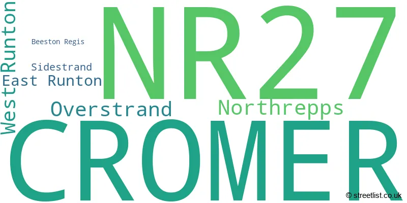
The largest settlement in the NR27 postal code is CROMER followed by Overstrand, and West Runton.
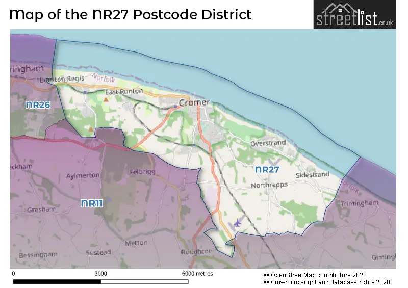
The postcode area has a boundary with The North Sea.
The NR27 Postcode shares a border with NR26 (SHERINGHAM, Beeston Regis, Upper Sheringham) and NR11 (Aylsham, Mundesley, Southrepps).
In the NR27 postcode district in Norfolk, the primary settlement is Cromer. Other significant settlements include Northrepps, Overstrand, and Sidestrand. The most significant post town is Cromer. The county is Norfolk in England.
For the district NR27, we have data on 3 postcode sectors. Here's a breakdown: The sector NR27 0, covers Cromer and Overstrand and Northrepps in Norfolk. The sector NR27 7 is non-geographic. It's often designated for PO Boxes, large organisations, or special services. The sector NR27 9, covers Cromer and West Runton and East Runton in Norfolk.

Map of the NR27 Postcode District
Explore the NR27 postcode district by using our free interactive map.
When it comes to local government, postal geography often disregards political borders. However, for a breakdown in the NR27 District: the district mostly encompasses the North Norfolk District area with a total of 400 postcodes.
Recent House Sales in NR27
| Date | Price | Address |
|---|---|---|
| 27/10/2023 | £200,000 | Vaughan Close, Cromer, NR27 0FE |
| 16/10/2023 | £206,000 | Mill Road, Cromer, NR27 0AD |
| 16/10/2023 | £315,000 | Holway Close, Cromer, NR27 9LH |
| 16/10/2023 | £370,000 | Corner Street, Cromer, NR27 9GY |
| 13/10/2023 | £290,000 | Alfred Road, Cromer, NR27 9AN |
| 11/10/2023 | £360,000 | Randall Crescent, Cromer, NR27 0FD |
| 11/10/2023 | £315,000 | Justice Court, Cromer, NR27 9EL |
| 06/10/2023 | £450,000 | Hillingdon Park, Overstrand, Cromer, NR27 0PG |
| 05/10/2023 | £83,500 | Runton House Close, West Runton, Cromer, NR27 9RA |
| 29/09/2023 | £285,000 | Louden Road, Cromer, NR27 9EG |
Weather Forecast for NR27
Press Button to Show Forecast for Cromer
| Time Period | Icon | Description | Temperature | Rain Probability | Wind |
|---|---|---|---|---|---|
| 03:00 to 06:00 | Cloudy | 4.0°C (feels like 1.0°C) | 8.00% | NW 7 mph | |
| 06:00 to 09:00 | Cloudy | 5.0°C (feels like 3.0°C) | 5.00% | NNW 7 mph | |
| 09:00 to 12:00 | Cloudy | 8.0°C (feels like 6.0°C) | 6.00% | NNE 7 mph | |
| 12:00 to 15:00 | Cloudy | 8.0°C (feels like 6.0°C) | 6.00% | NE 9 mph | |
| 15:00 to 18:00 | Cloudy | 9.0°C (feels like 7.0°C) | 6.00% | ENE 9 mph | |
| 18:00 to 21:00 | Cloudy | 8.0°C (feels like 6.0°C) | 5.00% | ENE 7 mph | |
| 21:00 to 00:00 | Partly cloudy (night) | 5.0°C (feels like 3.0°C) | 2.00% | ENE 7 mph |
Press Button to Show Forecast for Cromer
| Time Period | Icon | Description | Temperature | Rain Probability | Wind |
|---|---|---|---|---|---|
| 00:00 to 03:00 | Partly cloudy (night) | 6.0°C (feels like 4.0°C) | 5.00% | ENE 7 mph | |
| 03:00 to 06:00 | Cloudy | 5.0°C (feels like 2.0°C) | 10.00% | NE 9 mph | |
| 06:00 to 09:00 | Cloudy | 7.0°C (feels like 5.0°C) | 11.00% | ENE 9 mph | |
| 09:00 to 12:00 | Overcast | 9.0°C (feels like 6.0°C) | 20.00% | ENE 11 mph | |
| 12:00 to 15:00 | Cloudy | 10.0°C (feels like 8.0°C) | 13.00% | ENE 11 mph | |
| 15:00 to 18:00 | Cloudy | 10.0°C (feels like 8.0°C) | 12.00% | ENE 11 mph | |
| 18:00 to 21:00 | Cloudy | 9.0°C (feels like 7.0°C) | 11.00% | ENE 13 mph | |
| 21:00 to 00:00 | Cloudy | 9.0°C (feels like 6.0°C) | 21.00% | ENE 13 mph |
Press Button to Show Forecast for Cromer
| Time Period | Icon | Description | Temperature | Rain Probability | Wind |
|---|---|---|---|---|---|
| 00:00 to 03:00 | Light rain | 10.0°C (feels like 7.0°C) | 50.00% | E 13 mph | |
| 03:00 to 06:00 | Light rain | 10.0°C (feels like 7.0°C) | 49.00% | ESE 13 mph | |
| 06:00 to 09:00 | Light rain shower (day) | 10.0°C (feels like 8.0°C) | 40.00% | SE 13 mph | |
| 09:00 to 12:00 | Light rain shower (day) | 12.0°C (feels like 10.0°C) | 35.00% | SSE 13 mph | |
| 12:00 to 15:00 | Heavy rain shower (day) | 13.0°C (feels like 10.0°C) | 59.00% | SSE 16 mph | |
| 15:00 to 18:00 | Heavy rain shower (day) | 13.0°C (feels like 10.0°C) | 56.00% | S 16 mph | |
| 18:00 to 21:00 | Partly cloudy (day) | 12.0°C (feels like 9.0°C) | 11.00% | SSW 11 mph | |
| 21:00 to 00:00 | Partly cloudy (night) | 9.0°C (feels like 7.0°C) | 4.00% | SW 11 mph |
Where is the NR27 Postcode District?
The postcode district NR27 is located in the town of Cromer. Cromer is surrounded by nearby towns such as Sheringham to the West (4.49 miles away), North Walsham to the South East (8.01 miles away), Melton Constable to the South West (12.70 miles away), and Norwich to the South (20.67 miles away). Moreover, Cromer is approximately 114.81 miles away from the center of London.
The district is within the post town of CROMER.
The sector has postcodes within the nation of England.
The NR27 Postcode District is in the North and West Norfolk region of East Anglia within the East of England.
| Postcode Sector | Delivery Office |
|---|---|
| NR27 0 | Cromer Delivery Office |
| NR27 9 | Cromer Delivery Office |
| N | R | 2 | 7 | - | X | X | X |
| N | R | 2 | 7 | Space | Numeric | Letter | Letter |
Tourist Attractions within the Postcode Area
We found 1 visitor attractions within the NR27 postcode area
| RNLI Henry Blogg Museum |
|---|
| Museums & Art Galleries |
| Museum and / or Art Gallery |
| View RNLI Henry Blogg Museum on Google Maps |
Current Monthly Rental Prices
| # Bedrooms | Min Price | Max Price | Avg Price |
|---|---|---|---|
| £500 | £500 | £500 | |
| 1 | £520 | £750 | £693 |
| 2 | £800 | £800 | £800 |
Current House Prices
| # Bedrooms | Min Price | Max Price | Avg Price |
|---|---|---|---|
| £175,000 | £175,000 | £175,000 | |
| 1 | £90,000 | £280,000 | £137,222 |
| 2 | £45,000 | £475,000 | £249,459 |
| 3 | £199,950 | £1,395,000 | £390,435 |
| 4 | £260,000 | £1,000,000 | £494,524 |
| 5 | £325,000 | £750,000 | £579,545 |
| 6 | £600,000 | £900,000 | £775,000 |
| 9 | £1,750,000 | £1,750,000 | £1,750,000 |
| 10 | £1,100,000 | £1,100,000 | £1,100,000 |
Estate Agents who Operate in the NR27 District
| Logo | Name | Brand Name | Address | Contact Number | Total Properties |
|---|---|---|---|---|---|
 | Cromer | Henleys | 15 West Street, Cromer, NR27 9HZ | 01263 801361 | 51 |
 | Cromer | William H. Brown | 17-19 West Street, Cromer, NR27 9HZ | 01263 801120 | 28 |
 | Sheringham | Watsons | 58 Station Road, Sheringham, NR26 8RG | 01603 361981 | 19 |
 | Cromer | Abbotts | 41 Prince Of Wales Road, Cromer, Norfolk, NR27 9HS | 01263 801369 | 15 |
 | Holt | Sowerbys | 1 Market Place Holt NR25 6BE | 01263 801124 | 12 |
| Type of Property | 2018 Average | 2018 Sales | 2017 Average | 2017 Sales | 2016 Average | 2016 Sales | 2015 Average | 2015 Sales |
|---|---|---|---|---|---|---|---|---|
| Detached | £350,321 | 103 | £352,801 | 101 | £315,658 | 116 | £286,114 | 118 |
| Semi-Detached | £240,736 | 53 | £273,653 | 44 | £232,671 | 52 | £210,642 | 38 |
| Terraced | £230,024 | 82 | £220,526 | 76 | £203,376 | 75 | £195,019 | 71 |
| Flats | £173,269 | 88 | £144,863 | 82 | £162,243 | 173 | £142,270 | 104 |