The NR12 postcode district is a postal district located in the NR Norwich postcode area with a population of 21,362 residents according to the 2021 England and Wales Census.
The area of the NR12 postcode district is 70.75 square miles which is 183.23 square kilometres or 45,277.94 acres.
Currently, the NR12 district has about 914 postcode units spread across 4 geographic postcode sectors.
Given that each sector allows for 400 unique postcode combinations, the district has a capacity of 1,600 postcodes. With 914 postcodes already in use, this leaves 686 units available.
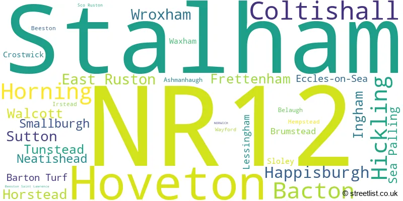
The largest settlement in the NR12 postal code is Stalham followed by Hoveton, and Bacton.
The postcode area has a boundary with The North Sea.
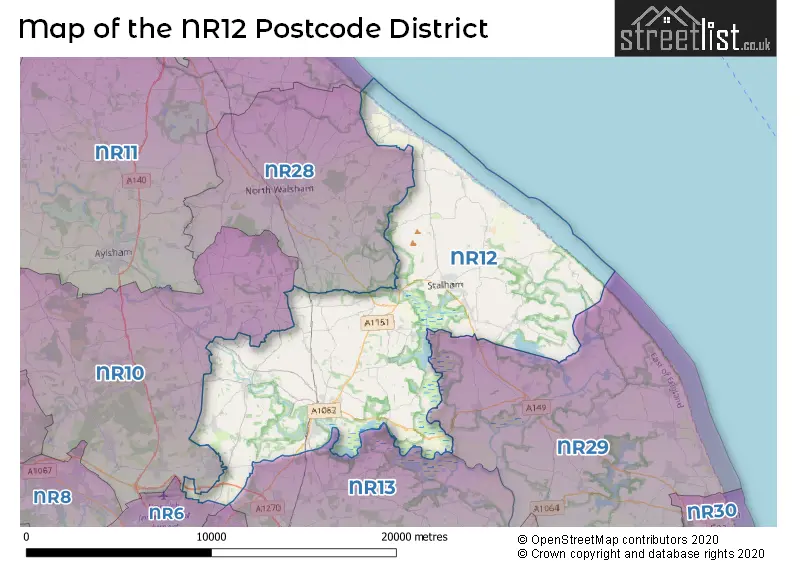
The NR12 Postcode shares a border with NR10 (Horsford, Spixworth, Reepham), NR28 (NORTH WALSHAM, Trunch, Worstead), NR6 (NORWICH, Hellesdon, Old Catton), NR7 (NORWICH, Sprowston, Thorpe St. Andrew), NR13 (Brundall, Rackheath, Blofield) and NR29 (Hemsby, Martham, Ormesby).
In the NR12 postcode district in Norfolk, England, the primary settlement is NORWICH. Other significant settlements in the district include Bacton, Eccles-on-Sea, Happisburgh, Hempstead, Hickling, Ingham, Lessingham, Sea Palling, Walcott, and Waxham. The most significant post town in the district is NORWICH.
For the district NR12, we have data on 4 postcode sectors. Here's a breakdown: The sector NR12 0, covers Bacton and Hickling and Happisburgh and Walcott in Norfolk. The sector NR12 7, covers Coltishall and Horstead and Frettenham in Norfolk. The sector NR12 8, covers Hoveton and Horning and Wroxham and Tunstead in Norfolk. The sector NR12 9, covers Stalham and East Ruston and Sutton and Smallburgh in Norfolk.

Map of the NR12 Postcode District
Explore the NR12 postcode district by using our free interactive map.
When it comes to local government, postal geography often disregards political borders. However, for a breakdown in the NR12 District: the district mostly encompasses the North Norfolk District (731 postcodes), and finally, the Broadland District area (185 postcodes).
Recent House Sales in NR12
| Date | Price | Address |
|---|---|---|
| 16/10/2023 | £273,988 | Rectory Road, Coltishall, Norwich, NR12 7HP |
| 10/10/2023 | £127,500 | Beach Road, Happisburgh, Norwich, NR12 0PP |
| 09/10/2023 | £205,000 | Strawberry Fields, Stalham, Norwich, NR12 9NZ |
| 02/10/2023 | £270,000 | Helena Road, Walcott, Norwich, NR12 0LX |
| 02/10/2023 | £250,000 | Helena Road, Walcott, Norwich, NR12 0LX |
| 28/09/2023 | £400,000 | Walcott Road, Bacton, Norwich, NR12 0EX |
| 28/09/2023 | £560,000 | Ferry View Estate, Horning, Norwich, NR12 8PT |
| 26/09/2023 | £100,000 | St Margarets Gardens, Hoveton, Norwich, NR12 8DN |
| 22/09/2023 | £212,000 | Sutton, Norwich, NR12 9QS |
| 18/09/2023 | £400,000 | St Johns Gardens, Stalham, Norwich, NR12 9DB |
Weather Forecast for NR12
Press Button to Show Forecast for Sea Palling
| Time Period | Icon | Description | Temperature | Rain Probability | Wind |
|---|---|---|---|---|---|
| 15:00 to 18:00 | Light rain | 8.0°C (feels like 4.0°C) | 51.00% | WSW 18 mph | |
| 18:00 to 21:00 | Cloudy | 8.0°C (feels like 5.0°C) | 47.00% | SW 11 mph | |
| 21:00 to 00:00 | Cloudy | 8.0°C (feels like 5.0°C) | 6.00% | SSW 11 mph |
Press Button to Show Forecast for Sea Palling
| Time Period | Icon | Description | Temperature | Rain Probability | Wind |
|---|---|---|---|---|---|
| 00:00 to 03:00 | Clear night | 7.0°C (feels like 4.0°C) | 0.00% | SSW 11 mph | |
| 03:00 to 06:00 | Clear night | 6.0°C (feels like 2.0°C) | 0.00% | SSW 11 mph | |
| 06:00 to 09:00 | Sunny day | 7.0°C (feels like 4.0°C) | 0.00% | SSW 11 mph | |
| 09:00 to 12:00 | Sunny day | 13.0°C (feels like 9.0°C) | 0.00% | SSW 16 mph | |
| 12:00 to 15:00 | Cloudy | 15.0°C (feels like 11.0°C) | 4.00% | S 18 mph | |
| 15:00 to 18:00 | Partly cloudy (day) | 15.0°C (feels like 11.0°C) | 1.00% | S 20 mph | |
| 18:00 to 21:00 | Sunny day | 13.0°C (feels like 10.0°C) | 0.00% | SSE 13 mph | |
| 21:00 to 00:00 | Clear night | 10.0°C (feels like 7.0°C) | 0.00% | SSE 11 mph |
Press Button to Show Forecast for Sea Palling
| Time Period | Icon | Description | Temperature | Rain Probability | Wind |
|---|---|---|---|---|---|
| 00:00 to 03:00 | Clear night | 9.0°C (feels like 6.0°C) | 0.00% | SSE 9 mph | |
| 03:00 to 06:00 | Clear night | 9.0°C (feels like 6.0°C) | 0.00% | SE 9 mph | |
| 06:00 to 09:00 | Sunny day | 11.0°C (feels like 9.0°C) | 0.00% | SE 9 mph | |
| 09:00 to 12:00 | Partly cloudy (day) | 14.0°C (feels like 12.0°C) | 2.00% | SE 11 mph | |
| 12:00 to 15:00 | Cloudy | 14.0°C (feels like 11.0°C) | 6.00% | SE 13 mph | |
| 15:00 to 18:00 | Cloudy | 14.0°C (feels like 11.0°C) | 5.00% | SE 13 mph | |
| 18:00 to 21:00 | Cloudy | 13.0°C (feels like 11.0°C) | 8.00% | SE 11 mph | |
| 21:00 to 00:00 | Light rain | 11.0°C (feels like 10.0°C) | 49.00% | ESE 9 mph |
Press Button to Show Forecast for Sea Palling
| Time Period | Icon | Description | Temperature | Rain Probability | Wind |
|---|---|---|---|---|---|
| 00:00 to 03:00 | Cloudy | 11.0°C (feels like 10.0°C) | 15.00% | SE 7 mph | |
| 03:00 to 06:00 | Overcast | 10.0°C (feels like 9.0°C) | 20.00% | ESE 4 mph | |
| 06:00 to 09:00 | Cloudy | 11.0°C (feels like 10.0°C) | 11.00% | NE 4 mph | |
| 09:00 to 12:00 | Cloudy | 12.0°C (feels like 11.0°C) | 11.00% | E 7 mph | |
| 12:00 to 15:00 | Cloudy | 13.0°C (feels like 12.0°C) | 7.00% | NNE 9 mph | |
| 15:00 to 18:00 | Cloudy | 12.0°C (feels like 10.0°C) | 6.00% | NNE 11 mph | |
| 18:00 to 21:00 | Cloudy | 11.0°C (feels like 9.0°C) | 8.00% | NNE 13 mph | |
| 21:00 to 00:00 | Cloudy | 11.0°C (feels like 8.0°C) | 8.00% | N 13 mph |
Press Button to Show Forecast for Sea Palling
| Time Period | Icon | Description | Temperature | Rain Probability | Wind |
|---|---|---|---|---|---|
| 00:00 to 03:00 | Cloudy | 11.0°C (feels like 8.0°C) | 7.00% | N 13 mph | |
| 03:00 to 06:00 | Clear night | 11.0°C (feels like 8.0°C) | 3.00% | N 13 mph | |
| 06:00 to 09:00 | Sunny day | 11.0°C (feels like 9.0°C) | 3.00% | NNE 13 mph | |
| 09:00 to 12:00 | Partly cloudy (day) | 12.0°C (feels like 10.0°C) | 2.00% | NNE 13 mph | |
| 12:00 to 15:00 | Partly cloudy (day) | 13.0°C (feels like 11.0°C) | 1.00% | NNE 13 mph | |
| 15:00 to 18:00 | Sunny day | 13.0°C (feels like 10.0°C) | 1.00% | NNE 16 mph | |
| 18:00 to 21:00 | Sunny day | 12.0°C (feels like 9.0°C) | 1.00% | NNE 13 mph | |
| 21:00 to 00:00 | Partly cloudy (night) | 11.0°C (feels like 9.0°C) | 2.00% | NNE 13 mph |
Where is the NR12 Postcode District?
The NR12 postcode district is located in the town of Norwich. It is nearby various towns such as North Walsham to the North West, Great Yarmouth to the South East, Melton Constable to the West, Wymondham to the South West, and Beccles to the South. The distance from NR12 to London is approximately 109.7 miles.
The district is within the post town of NORWICH.
The sector has postcodes within the nation of England.
The NR12 Postcode District is covers the following regions.
- North and West Norfolk - East Anglia - East of England
- Norwich and East Norfolk - East Anglia - East of England
| Postcode Sector | Delivery Office |
|---|---|
| NR12 0 | North Walsham Delivery Office |
| NR12 0 | Stalham Scale Payment Delivery Office |
| NR12 7 | Coltishall Scale Payment Delivery Office |
| NR12 8 | Wroxham Scale Payment Delivery Office |
| NR12 9 | Stalham Scale Payment Delivery Office |
| N | R | 1 | 2 | - | X | X | X |
| N | R | 1 | 2 | Space | Numeric | Letter | Letter |
Tourist Attractions within the Postcode Area
We found 4 visitor attractions within the NR12 postcode area
| Liana (Boat Trip) |
|---|
| Wildlife |
| Nature Reserve / Wetlands / Wildlife Trips |
| View Liana (Boat Trip) on Google Maps |
| Barton House Railway |
| Railways |
| Steam / Heritage Railway |
| View Barton House Railway on Google Maps |
| Hoveton Hall Gardens |
| Gardens |
| Garden |
| View Hoveton Hall Gardens on Google Maps |
| Waxham Barn |
| Farms |
| Farm / Rare Breeds / Farm Animals |
| View Waxham Barn on Google Maps |
Current Monthly Rental Prices
| # Bedrooms | Min Price | Max Price | Avg Price |
|---|---|---|---|
| £350 | £1,000 | £675 | |
| 1 | £750 | £1,405 | £1,208 |
| 2 | £850 | £1,050 | £950 |
| 3 | £1,200 | £1,650 | £1,425 |
| 4 | £1,500 | £1,900 | £1,633 |
| 5 | £2,250 | £2,250 | £2,250 |
Current House Prices
| # Bedrooms | Min Price | Max Price | Avg Price |
|---|---|---|---|
| £5,000 | £350,000 | £146,250 | |
| 1 | £120,000 | £250,000 | £180,000 |
| 2 | £24,999 | £550,000 | £216,767 |
| 3 | £53,950 | £950,000 | £389,065 |
| 4 | £300,000 | £975,000 | £588,182 |
| 5 | £350,000 | £1,400,000 | £772,500 |
| 6 | £425,000 | £1,900,000 | £882,143 |
| 7 | £1,100,000 | £2,250,000 | £1,675,000 |
| 8 | £1,100,000 | £4,000,000 | £2,550,000 |
| 10 | £1,050,000 | £1,050,000 | £1,050,000 |
| 14 | £1,250,000 | £1,250,000 | £1,250,000 |
Estate Agents who Operate in the NR12 District
| Logo | Name | Brand Name | Address | Contact Number | Total Properties |
|---|---|---|---|---|---|
 | Wroxham | Minors & Brady | Church Road, Wroxham, NR12 8UG | 01603 361595 | 29 |
 | Wroxham | Stobart & Hurrell | Unit 3A Station Business Park, Horning Road West, Wroxham, NR12 8QJ | 01603 361930 | 27 |
 | Stalham | Trett Phillips | 142 High Street, Stalham, NR12 9AZ | 01692 660095 | 26 |
 | Stalham | William H. Brown | 52 High Street, Stalham, NR12 9AS | 01692 660116 | 25 |
 | Wroxham | Abbotts | 2 Broads Centre Hoveton Wroxham NR12 8AJ | 01603 361377 | 25 |
- Ashmanhaugh
- Bacton
- Badersfield
- Barton Turf
- Belaugh
- Broomholm
- Brumstead
- Butcher's Common
- Buxton
- Cat's Common
- Coltishall
- Crostwick
- Dilham
- East Ruston
- Eccles on Sea
- Frankfort
- Frettenham
- Great Hautbois
- Hainford
- Happisburgh Common
- Happisburgh
- Hempstead
- Hickling
- Horning
- Horsey
- Horstead
- Hoveton
- Ingham Corner
- Ingham
- Irstead
- Keswick
- Lessingham
- Lower Street
- Neatishead
- Norwich
- Pennygate
- Pollard Street
- Potter Heigham
- Ridlington Street
- Scottow
- Sea Palling
- Sloley
- Smallburgh
- Spixworth
- St James
- Stalham
- Sutton
- Threehammer Common
- Tunstead
- Upper Street
- Upper Street
- Walcott Green
- Walcott
- Whimpwell Green
- Workhouse Common
- Wroxham
| Type of Property | 2018 Average | 2018 Sales | 2017 Average | 2017 Sales | 2016 Average | 2016 Sales | 2015 Average | 2015 Sales |
|---|---|---|---|---|---|---|---|---|
| Detached | £359,416 | 224 | £336,563 | 272 | £324,824 | 305 | £283,866 | 272 |
| Semi-Detached | £210,770 | 99 | £222,741 | 108 | £199,127 | 134 | £181,885 | 106 |
| Terraced | £212,520 | 63 | £200,957 | 79 | £204,243 | 77 | £190,526 | 102 |
| Flats | £124,385 | 35 | £132,362 | 31 | £114,359 | 15 | £100,466 | 25 |