The NR33 postcode district is a postal district located in the NR Norwich postcode area with a population of 39,218 residents according to the 2021 England and Wales Census.
The area of the NR33 postcode district is 13.47 square miles which is 34.89 square kilometres or 8,621.39 acres.
Currently, the NR33 district has about 923 postcode units spread across 4 geographic postcode sectors.
Given that each sector allows for 400 unique postcode combinations, the district has a capacity of 1,600 postcodes. With 923 postcodes already in use, this leaves 677 units available.
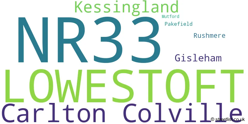
The largest settlement in the NR33 postal code is LOWESTOFT followed by Carlton Colville, and Kessingland.
The postcode area has a boundary with The North Sea.
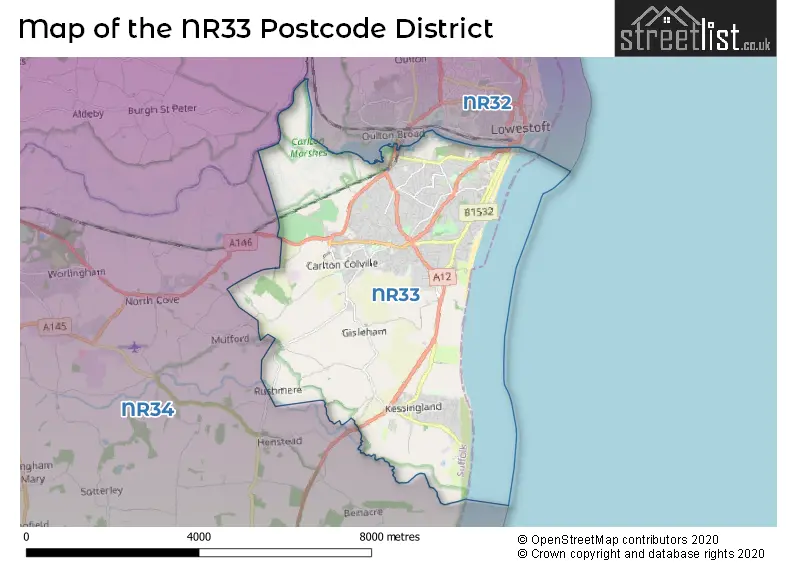
The NR33 Postcode shares a border with NR34 (BECCLES, Worlingham, Wrentham) and NR32 (LOWESTOFT, Oulton, Corton).
In the NR33 postcode district in Suffolk, the primary settlement is Lowestoft. Other significant settlements in this district include Gisleham, Kessingland, Pakefield, Carlton Colville, Mutford, and Rushmere. The county in which these settlements are located is Suffolk. The most significant post town in this postcode district is Lowestoft.
For the district NR33, we have data on 4 postcode sectors. Here's a breakdown: The sector NR33 0, covers Lowestoft in Suffolk. The sector NR33 7, covers Lowestoft and Kessingland in Suffolk. The sector NR33 8, covers Carlton Colville and Lowestoft in Suffolk. The sector NR33 9, covers Lowestoft in Suffolk.

Map of the NR33 Postcode District
Explore the NR33 postcode district by using our free interactive map.
When it comes to local government, postal geography often disregards political borders. However, for a breakdown in the NR33 District: the district mostly encompasses the East Suffolk District area with a total of 926 postcodes.
Recent House Sales in NR33
| Date | Price | Address |
|---|---|---|
| 23/10/2023 | £158,000 | St Johns Road, Lowestoft, NR33 0PH |
| 17/10/2023 | £160,000 | Lorne Park Road, Lowestoft, NR33 0RB |
| 13/10/2023 | £255,000 | Borrow Close, Carlton Colville, Lowestoft, NR33 8AP |
| 13/10/2023 | £285,000 | Ship Road, Lowestoft, NR33 7DW |
| 06/10/2023 | £205,000 | Heigham Drive, Lowestoft, NR33 9DY |
| 06/10/2023 | £247,500 | Prospect Place, Lowestoft, NR33 7DA |
| 02/10/2023 | £216,000 | Springfield Gardens, Lowestoft, NR33 9EE |
| 22/09/2023 | £230,000 | Wilson Road, Lowestoft, NR33 0HZ |
| 15/09/2023 | £292,500 | Famona Road, Carlton Colville, Lowestoft, NR33 8JU |
| 14/09/2023 | £302,000 | Chalmers Green, Carlton Colville, Lowestoft, NR33 8FY |
Weather Forecast for NR33
Press Button to Show Forecast for Lowestoft - South Of Claremont Pier (Beach)
| Time Period | Icon | Description | Temperature | Rain Probability | Wind |
|---|---|---|---|---|---|
| 06:00 to 09:00 | Light rain | 8.0°C (feels like 5.0°C) | 53.00% | ENE 13 mph | |
| 09:00 to 12:00 | Light rain | 8.0°C (feels like 5.0°C) | 53.00% | ENE 13 mph | |
| 12:00 to 15:00 | Overcast | 9.0°C (feels like 6.0°C) | 14.00% | ENE 13 mph | |
| 15:00 to 18:00 | Overcast | 10.0°C (feels like 7.0°C) | 10.00% | ENE 11 mph | |
| 18:00 to 21:00 | Cloudy | 10.0°C (feels like 7.0°C) | 8.00% | ENE 11 mph | |
| 21:00 to 00:00 | Heavy rain | 9.0°C (feels like 6.0°C) | 88.00% | NE 13 mph |
Press Button to Show Forecast for Lowestoft - South Of Claremont Pier (Beach)
| Time Period | Icon | Description | Temperature | Rain Probability | Wind |
|---|---|---|---|---|---|
| 00:00 to 03:00 | Heavy rain | 10.0°C (feels like 7.0°C) | 91.00% | ENE 13 mph | |
| 03:00 to 06:00 | Heavy rain | 10.0°C (feels like 7.0°C) | 93.00% | ESE 16 mph | |
| 06:00 to 09:00 | Light rain | 10.0°C (feels like 7.0°C) | 57.00% | ESE 16 mph | |
| 09:00 to 12:00 | Light rain shower (day) | 11.0°C (feels like 8.0°C) | 44.00% | SSW 18 mph | |
| 12:00 to 15:00 | Light rain shower (day) | 12.0°C (feels like 9.0°C) | 41.00% | SW 16 mph | |
| 15:00 to 18:00 | Light rain shower (day) | 10.0°C (feels like 8.0°C) | 38.00% | W 13 mph | |
| 18:00 to 21:00 | Cloudy | 9.0°C (feels like 7.0°C) | 12.00% | WSW 9 mph | |
| 21:00 to 00:00 | Partly cloudy (night) | 8.0°C (feels like 6.0°C) | 2.00% | SW 9 mph |
Press Button to Show Forecast for Lowestoft - South Of Claremont Pier (Beach)
| Time Period | Icon | Description | Temperature | Rain Probability | Wind |
|---|---|---|---|---|---|
| 00:00 to 03:00 | Clear night | 7.0°C (feels like 5.0°C) | 2.00% | SW 9 mph | |
| 03:00 to 06:00 | Clear night | 6.0°C (feels like 4.0°C) | 1.00% | SSW 7 mph | |
| 06:00 to 09:00 | Sunny day | 7.0°C (feels like 5.0°C) | 1.00% | SSW 7 mph | |
| 09:00 to 12:00 | Sunny day | 12.0°C (feels like 9.0°C) | 0.00% | S 11 mph | |
| 12:00 to 15:00 | Partly cloudy (day) | 13.0°C (feels like 11.0°C) | 2.00% | S 11 mph | |
| 15:00 to 18:00 | Partly cloudy (day) | 13.0°C (feels like 11.0°C) | 2.00% | SSE 11 mph | |
| 18:00 to 21:00 | Partly cloudy (day) | 12.0°C (feels like 10.0°C) | 1.00% | SE 11 mph | |
| 21:00 to 00:00 | Partly cloudy (night) | 10.0°C (feels like 8.0°C) | 1.00% | SE 9 mph |
Press Button to Show Forecast for Lowestoft - South Of Claremont Pier (Beach)
| Time Period | Icon | Description | Temperature | Rain Probability | Wind |
|---|---|---|---|---|---|
| 00:00 to 03:00 | Partly cloudy (night) | 9.0°C (feels like 7.0°C) | 2.00% | SE 9 mph | |
| 03:00 to 06:00 | Mist | 9.0°C (feels like 7.0°C) | 16.00% | ESE 7 mph | |
| 06:00 to 09:00 | Overcast | 10.0°C (feels like 9.0°C) | 11.00% | E 9 mph | |
| 09:00 to 12:00 | Cloudy | 13.0°C (feels like 11.0°C) | 18.00% | ESE 9 mph | |
| 12:00 to 15:00 | Cloudy | 14.0°C (feels like 12.0°C) | 8.00% | ESE 9 mph | |
| 15:00 to 18:00 | Cloudy | 14.0°C (feels like 12.0°C) | 7.00% | SE 9 mph | |
| 18:00 to 21:00 | Cloudy | 13.0°C (feels like 11.0°C) | 10.00% | E 9 mph | |
| 21:00 to 00:00 | Light rain shower (night) | 12.0°C (feels like 10.0°C) | 41.00% | E 9 mph |
Where is the NR33 Postcode District?
The postcode district NR33 is located in the town of Lowestoft. It is surrounded by several nearby towns, including Beccles to the West (5.38 miles away), Southwold to the South (8.33 miles away), Halesworth to the South West (10.90 miles away), and Great Yarmouth to the North (11.15 miles away). Additionally, the postcode district is approximately 101.48 miles away from the center of London.
The district is within the post town of LOWESTOFT.
The sector has postcodes within the nation of England.
The NR33 Postcode District is in the region of within the .
| Postcode Sector | Delivery Office |
|---|---|
| NR33 0 | Lowestoft Delivery Office |
| NR33 7 | Lowestoft Delivery Office |
| NR33 8 | Lowestoft Delivery Office |
| NR33 9 | Lowestoft Delivery Office |
| N | R | 3 | 3 | - | X | X | X |
| N | R | 3 | 3 | Space | Numeric | Letter | Letter |
Tourist Attractions within the Postcode Area
We found 2 visitor attractions within the NR33 postcode area
| East Anglia Transport Museum |
|---|
| Museums & Art Galleries |
| Museum and / or Art Gallery |
| View East Anglia Transport Museum on Google Maps |
| Lowestoft Museum in Broad House |
| Museums & Art Galleries |
| Museum and / or Art Gallery |
| View Lowestoft Museum in Broad House on Google Maps |
Current Monthly Rental Prices
| # Bedrooms | Min Price | Max Price | Avg Price |
|---|---|---|---|
| £125 | £125 | £125 | |
| 1 | £550 | £800 | £708 |
| 2 | £675 | £1,200 | £877 |
| 3 | £750 | £975 | £860 |
| 4 | £995 | £1,850 | £1,285 |
Current House Prices
| # Bedrooms | Min Price | Max Price | Avg Price |
|---|---|---|---|
| £30,000 | £850,000 | £264,167 | |
| 1 | £30,000 | £200,000 | £120,625 |
| 2 | £30,000 | £350,000 | £198,325 |
| 3 | £60,000 | £600,000 | £254,967 |
| 4 | £175,000 | £950,000 | £398,191 |
| 5 | £180,000 | £995,000 | £470,000 |
| 6 | £300,000 | £700,000 | £395,000 |
| 7 | £575,000 | £575,000 | £575,000 |
Estate Agents who Operate in the NR33 District
| Logo | Name | Brand Name | Address | Contact Number | Total Properties |
|---|---|---|---|---|---|
 | Lowestoft | Paul Hubbard Estate Agents | 178-180 London Road South, Lowestoft, NR33 0BB | 01501 648928 | 88 |
 | Lowestoft | Minors & Brady | 142 London Road North, Lowestoft, NR32 1HB | 01502 441421 | 73 |
 | Lowestoft | William H. Brown | 138 London Road North, Lowestoft, NR32 1HB | 01502 442472 | 42 |
 | Lowestoft | Howards | 164-166 London Road North, Lowestoft, NR32 1HB | 01502 442460 | 39 |
 | Lowestoft | Ange & Co | Ange & Co, Ivy Lane, Oulton Broad, Lowestoft, Suffolk, NR33 8QH | 01502 447867 | 37 |
| Type of Property | 2018 Average | 2018 Sales | 2017 Average | 2017 Sales | 2016 Average | 2016 Sales | 2015 Average | 2015 Sales |
|---|---|---|---|---|---|---|---|---|
| Detached | £251,082 | 245 | £243,088 | 264 | £231,929 | 235 | £211,283 | 220 |
| Semi-Detached | £179,231 | 205 | £171,721 | 225 | £159,368 | 234 | £149,697 | 209 |
| Terraced | £147,476 | 262 | £138,307 | 251 | £129,002 | 268 | £124,078 | 237 |
| Flats | £133,831 | 27 | £130,222 | 18 | £116,910 | 35 | £95,353 | 29 |