The NR14 postcode district is a postal district located in the NR Norwich postcode area with a population of 27,394 residents according to the 2021 England and Wales Census.
The area of the NR14 postcode district is 71.25 square miles which is 184.53 square kilometres or 45,599.50 acres.
Currently, the NR14 district has about 920 postcode units spread across 3 geographic postcode sectors.
Given that each sector allows for 400 unique postcode combinations, the district has a capacity of 1,200 postcodes. With 920 postcodes already in use, this leaves 280 units available.
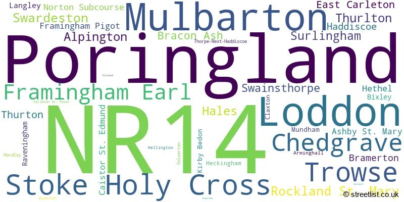
The largest settlement in the NR14 postal code is Poringland followed by Mulbarton, and Loddon.
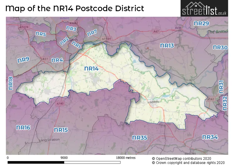
The NR14 Postcode shares a border with NR35 (BUNGAY, Ditchingham, Earsham), NR34 (BECCLES, Worlingham, Wrentham), NR4 (NORWICH, Cringleford, Colney), NR7 (NORWICH, Sprowston, Thorpe St. Andrew), NR1 (NORWICH), NR13 (Brundall, Rackheath, Blofield), NR15 (Long Stratton, Brooke, Hempnall), NR16 (East Harling, Banham, Bunwell), NR18 (WYMONDHAM, Wicklewood, Deopham) and NR31 (Gorleston, Bradwell, GREAT YARMOUTH).
The primary settlement in the NR14 postcode district is Loddon, located in the county of Norfolk, England. Other significant settlements include Poringland, Mulbarton, and Stoke Holy Cross, all located in Norfolk. The post town associated with this postcode district is Norwich.
For the district NR14, we have data on 3 postcode sectors. Here's a breakdown: The sector NR14 6, covers Loddon and Chedgrave in Norfolk. The sector NR14 7, covers Poringland and Framingham Earl in Norfolk. The sector NR14 8, covers Mulbarton and Stoke Holy Cross and Trowse in Norfolk.

Map of the NR14 Postcode District
Explore the NR14 postcode district by using our free interactive map.
When it comes to local government, postal geography often disregards political borders. However, for a breakdown in the NR14 District: the district mostly encompasses the South Norfolk District (926 postcodes), and finally, the Broadland District area (4 postcodes).
Recent House Sales in NR14
| Date | Price | Address |
|---|---|---|
| 20/10/2023 | £447,500 | Tench Close, Mulbarton, Norwich, NR14 8FX |
| 18/10/2023 | £300,000 | Cedar Drive, Loddon, Norwich, NR14 6LE |
| 16/10/2023 | £490,000 | Yarmouth Road, Thorpe Next Haddiscoe, Norwich, NR14 6PU |
| 10/10/2023 | £275,000 | Southern Reach, Mulbarton, Norwich, NR14 8BU |
| 29/09/2023 | £272,500 | Longfield Close, Loddon, Norwich, NR14 6UU |
| 29/09/2023 | £360,000 | Springfields, Poringland, Norwich, NR14 7RG |
| 13/09/2023 | £340,000 | Lakes Avenue, Mulbarton, Norwich, NR14 8BY |
| 12/09/2023 | £467,500 | Hardley Road, Poringland, Norwich, NR14 7UR |
| 08/09/2023 | £392,000 | Church Road, Yelverton, Norwich, NR14 7PB |
| 07/09/2023 | £280,000 | Cannell Road, Loddon, Norwich, NR14 6DW |
Weather Forecast for NR14
Press Button to Show Forecast for Rainthorpe Hall
| Time Period | Icon | Description | Temperature | Rain Probability | Wind |
|---|---|---|---|---|---|
| 03:00 to 06:00 | Cloudy | 5.0°C (feels like 3.0°C) | 8.00% | NE 4 mph | |
| 06:00 to 09:00 | Overcast | 7.0°C (feels like 4.0°C) | 50.00% | NE 7 mph | |
| 09:00 to 12:00 | Light rain | 8.0°C (feels like 5.0°C) | 51.00% | ENE 11 mph | |
| 12:00 to 15:00 | Overcast | 9.0°C (feels like 6.0°C) | 20.00% | ENE 11 mph | |
| 15:00 to 18:00 | Overcast | 10.0°C (feels like 7.0°C) | 12.00% | NE 11 mph | |
| 18:00 to 21:00 | Overcast | 9.0°C (feels like 7.0°C) | 13.00% | NE 9 mph | |
| 21:00 to 00:00 | Light rain | 9.0°C (feels like 6.0°C) | 82.00% | NE 11 mph |
Press Button to Show Forecast for Rainthorpe Hall
| Time Period | Icon | Description | Temperature | Rain Probability | Wind |
|---|---|---|---|---|---|
| 00:00 to 03:00 | Heavy rain | 9.0°C (feels like 6.0°C) | 90.00% | NE 11 mph | |
| 03:00 to 06:00 | Heavy rain | 9.0°C (feels like 7.0°C) | 92.00% | ENE 9 mph | |
| 06:00 to 09:00 | Heavy rain | 10.0°C (feels like 8.0°C) | 78.00% | E 11 mph | |
| 09:00 to 12:00 | Thunder shower (day) | 11.0°C (feels like 8.0°C) | 67.00% | SW 13 mph | |
| 12:00 to 15:00 | Heavy rain shower (day) | 11.0°C (feels like 8.0°C) | 68.00% | WSW 13 mph | |
| 15:00 to 18:00 | Light rain | 10.0°C (feels like 7.0°C) | 57.00% | W 13 mph | |
| 18:00 to 21:00 | Cloudy | 9.0°C (feels like 7.0°C) | 12.00% | WSW 9 mph | |
| 21:00 to 00:00 | Partly cloudy (night) | 8.0°C (feels like 6.0°C) | 3.00% | SW 9 mph |
Press Button to Show Forecast for Rainthorpe Hall
| Time Period | Icon | Description | Temperature | Rain Probability | Wind |
|---|---|---|---|---|---|
| 00:00 to 03:00 | Partly cloudy (night) | 7.0°C (feels like 4.0°C) | 2.00% | SW 7 mph | |
| 03:00 to 06:00 | Clear night | 5.0°C (feels like 3.0°C) | 1.00% | SSW 7 mph | |
| 06:00 to 09:00 | Sunny day | 6.0°C (feels like 4.0°C) | 1.00% | S 7 mph | |
| 09:00 to 12:00 | Sunny day | 12.0°C (feels like 10.0°C) | 1.00% | SSW 11 mph | |
| 12:00 to 15:00 | Cloudy | 14.0°C (feels like 12.0°C) | 6.00% | S 11 mph | |
| 15:00 to 18:00 | Cloudy | 14.0°C (feels like 11.0°C) | 6.00% | SSE 13 mph | |
| 18:00 to 21:00 | Sunny day | 12.0°C (feels like 10.0°C) | 1.00% | SE 9 mph | |
| 21:00 to 00:00 | Clear night | 9.0°C (feels like 7.0°C) | 1.00% | SE 7 mph |
Press Button to Show Forecast for Rainthorpe Hall
| Time Period | Icon | Description | Temperature | Rain Probability | Wind |
|---|---|---|---|---|---|
| 00:00 to 03:00 | Partly cloudy (night) | 8.0°C (feels like 6.0°C) | 2.00% | SE 7 mph | |
| 03:00 to 06:00 | Partly cloudy (night) | 7.0°C (feels like 6.0°C) | 6.00% | ESE 7 mph | |
| 06:00 to 09:00 | Overcast | 10.0°C (feels like 8.0°C) | 11.00% | E 7 mph | |
| 09:00 to 12:00 | Cloudy | 13.0°C (feels like 12.0°C) | 9.00% | ESE 7 mph | |
| 12:00 to 15:00 | Cloudy | 15.0°C (feels like 13.0°C) | 9.00% | SE 9 mph | |
| 15:00 to 18:00 | Cloudy | 15.0°C (feels like 14.0°C) | 7.00% | SE 9 mph | |
| 18:00 to 21:00 | Cloudy | 14.0°C (feels like 13.0°C) | 7.00% | ESE 9 mph | |
| 21:00 to 00:00 | Cloudy | 12.0°C (feels like 10.0°C) | 11.00% | E 7 mph |
Where is the NR14 Postcode District?
The postcode district for NR14 is in Norwich, which is located in the South of England. It is nearby towns such as Bungay (8.06 miles away), Beccles (10.23 miles away), Great Yarmouth (12.65 miles away), Wymondham (12.92 miles away), and Diss (16.63 miles away). Additionally, it is approximately 97.95 miles away from the center of London.
The district is within the post town of NORWICH.
The sector has postcodes within the nation of England.
The NR14 Postcode District is covers the following regions.
- Breckland and South Norfolk - East Anglia - East of England
- Norwich and East Norfolk - East Anglia - East of England
| Postcode Sector | Delivery Office |
|---|---|
| NR14 6 | Loddelivery Officen Scale Payment Delivery Office |
| NR14 6 | Brooke Scale Payment Delivery Office |
| NR14 7 | Framingham Earl Scale Payment Delivery Office |
| NR14 7 | Norwich Delivery Office |
| NR14 8 | Norwich Delivery Office |
| NR14 8 | Wymondham Delivery Office |
| NR14 8 | Mulbarton Scale Payment Delivery Office |
| N | R | 1 | 4 | - | X | X | X |
| N | R | 1 | 4 | Space | Numeric | Letter | Letter |
Tourist Attractions within the Postcode Area
We found 2 visitor attractions within the NR14 postcode area
| Whitlingham Country Park |
|---|
| Country Parks |
| Country Park |
| View Whitlingham Country Park on Google Maps |
| Seething Restored WW2 Control Tower |
| Museums & Art Galleries |
| Museum and / or Art Gallery |
| View Seething Restored WW2 Control Tower on Google Maps |
Current Monthly Rental Prices
| # Bedrooms | Min Price | Max Price | Avg Price |
|---|---|---|---|
| £1,250 | £1,250 | £1,250 | |
| 1 | £695 | £695 | £695 |
| 2 | £1,150 | £1,150 | £1,150 |
| 3 | £1,150 | £1,400 | £1,250 |
| 4 | £1,550 | £1,550 | £1,550 |
Current House Prices
| # Bedrooms | Min Price | Max Price | Avg Price |
|---|---|---|---|
| £25,000 | £650,000 | £304,167 | |
| 1 | £125,000 | £170,000 | £158,750 |
| 2 | £79,995 | £525,000 | £272,285 |
| 3 | £30,000 | £725,000 | £384,859 |
| 4 | £250,000 | £915,000 | £555,347 |
| 5 | £425,000 | £1,650,000 | £769,130 |
| 6 | £575,000 | £2,600,000 | £1,202,273 |
| 7 | £1,100,000 | £3,900,000 | £1,800,000 |
| 8 | £2,350,000 | £2,350,000 | £2,350,000 |
| 9 | £550,000 | £2,600,000 | £1,575,000 |
Estate Agents who Operate in the NR14 District
| Logo | Name | Brand Name | Address | Contact Number | Total Properties |
|---|---|---|---|---|---|
 | Poringland | Winkworth | Unit 2 Overtons Way, Poringland, NR14 7WB | 01508 528880 | 49 |
 | Poringland | Starkings & Watson | 2a Shotesham Road, Poringland, NR14 7LE | 01508 356456 | 37 |
 | Unthank Road, Norwich | Minors & Brady | 107 Unthank Road, Norwich, NR2 2PE | 01603 361834 | 14 |
 | Loddon | Musker McIntyre | 22 High Street, Loddon, NR14 6AH | 01508 505226 | 11 |
 | Norwich | Pymm & Co | 4 Ber Street Norwich NR1 3EJ | 01603 361642 | 8 |
- Alpington
- Arminghall
- Ashby St Mary
- Bergh Apton
- Bracon Ash
- Bramerton
- Brundall
- Bull's Green
- Caistor St Edmund
- Carleton St Peter
- Chedgrave
- Claxton
- Dunston
- East Carleton
- Framingham Earl
- Framingham Pigot
- Haddiscoe
- Hales
- Hardley Street
- Heckingham
- Hellington Corner
- Hellington
- Keswick
- Kirby Bedon
- Langley Street
- Limpenhoe
- Loddon
- Lower East Carleton
- Lower Thurlton
- Mulbarton
- Mundham Common
- Mundham
- Nogdam End
- Norton Subcourse
- Norwich
- Poringland
- Raveningham
- Reedham
- Rockland St Mary
- Seething
- Shotesham
- Sisland
- Stoke Holy Cross
- Surlingham
- Swainsthorpe
- Swardeston
- Thorpe
- Thurlton
- Thurton
- Trowse Newton
- Upgate
- Upper Stoke
- Whitlingham
- Wreningham
- Yelverton
| Type of Property | 2018 Average | 2018 Sales | 2017 Average | 2017 Sales | 2016 Average | 2016 Sales | 2015 Average | 2015 Sales |
|---|---|---|---|---|---|---|---|---|
| Detached | £386,366 | 309 | £355,527 | 336 | £343,653 | 272 | £308,579 | 239 |
| Semi-Detached | £260,193 | 134 | £238,440 | 157 | £235,375 | 159 | £206,365 | 91 |
| Terraced | £211,058 | 117 | £213,030 | 96 | £204,574 | 132 | £205,304 | 79 |
| Flats | £132,929 | 17 | £152,136 | 27 | £124,614 | 47 | £145,780 | 33 |