This section of the site is all about the CM Postcode area, also known as the Chelmsford Postal Area. Explore links to the next level to learn more about specific postcode districts such as CM0.
The CM postcode area represents a group of postal districts in the Chelmsford area of the United Kingdom. The area code CM stands for the letters c and m in ChelMsford. CM has a population of 653,492 and covers an area of 1,791,944 hectares. Fun fact: 1.01% of the population of Great Britain lives in this area.
The postcode area falls within the following counties: Essex (92.41%), Hertfordshire (7.57%), Greater London (0.01%).
Post Towns and Postcode Districts for the CM Postcode
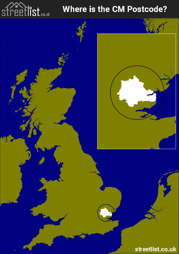
Where is the CM Postcode Area?
The CM Chelmsford Postcode is in the East of England. The postal area borders the following neighbouring postal areas: SS - Southend-on-Sea, CO - Colchester, CB - Cambridge, SG - Stevenage, RM - Romford, EN - Enfield and IG - Ilford, It also borders The Blackwater and The Thames Estuary.
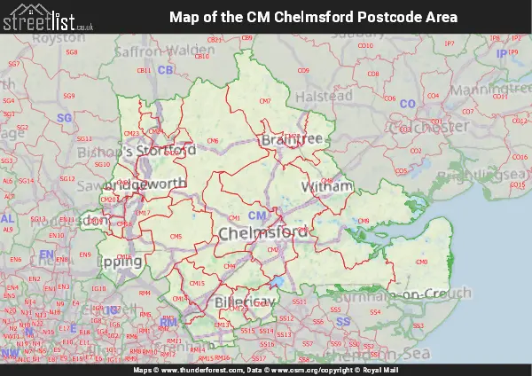
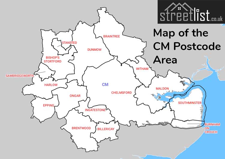
Map of the CM Chelmsford Postcode Area
Explore the CM Chelmsford postcode area by using our interactive map.
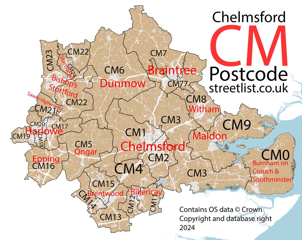
Postcode Districts within the CM Chelmsford Postcode Area
There are 25 postcode districts within the Chelmsford postcode area
A map showing the boundary of in relation to other areas
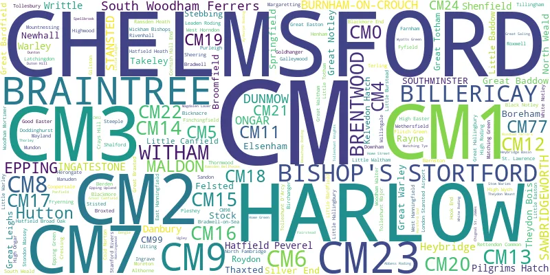
There are 19 towns within the Chelmsford postcode area.
| Unit | Area² |
|---|---|
| Hectares | 1,791,944² |
| Miles | 6,919² |
| Feet | 192,883,060,216² |
| Kilometres | 17,919² |
Postal Delivery Offices serving the CM Chelmsford Postcode Area
- Althorne Scale Payment Delivery Office
- Billericay Delivery Office
- Bishops Stortford Delivery Office
- Blackmore Scale Payment Delivery Office
- Boreham Scale Payment Delivery Office
- Braintree Delivery Office
- Brentwood Delivery Office
- Burnham On Crouch Scale Payment Delivery Office
- Chelmsford Delivery Office
- Danbury Scale Payment Delivery Office
- Dunmow Delivery Office
- Elsenham Scale Payment Delivery Office
- Epping Delivery Office
- Finchingfield Scale Payment Delivery Office
- Harlow Delivery Office
- Hatfield Peverel Scale Payment Delivery Office
- Ingatestone Scale Payment Delivery Office
- Latching Delivery Office N Scale Payment Delivery Office
- Maldon Delivery Office
- Ongar Delivery Office
- Purleigh Scale Payment Delivery Office
- Sawbridgeworth Delivery Office
- Silver End Scale Payment Delivery Office
- South Woodham Ferrers Delivery Office
- Southminster Scale Payment Delivery Office
- Stansted Scale Payment Delivery Office
- Takeley Scale Payment Delivery Office
- Tollesbury Scale Payment Delivery Office
- Wethersfield Scale Payment Delivery Office
- Wickham Bishops Scale Payment Delivery Office
- Witham Delivery Office
Councils with Postcodes in CM
Towns and Villages within the CM Chelmsford Postcode Area
- Abbess Roding - village
- Allen's Green - village
- Althorne - village
- Ardley End - village
- Asheldham - village
- Bannister Green - village
- Bardfield End Green - village
- Bardfield Saling - village
- Barnston - village
- Basildon - town
- Beacon Hill - village
- Bedlar's Green - village
- Berden - village
- Bicknacre - village
- Billericay - town
- Birchanger - village
- Bishop's Stortford - town
- Black Notley - village
- Blackmore - village
- Blackmore End - village
- Boreham - village
- Boyton Cross - village
- Bradwell - village
- Bradwell on Sea - village
- Bradwell Waterside - village
- Braintree - town
- Brentwood - town
- Brick End - village
- Broad's Green - village
- Brock Hill - village
- Broomfield - village
- Broxted - village
- Burnham-on-Crouch - town
- Burton End - village
- Causeway End - village
- Chatham Green - village
- Chelmsford - city
- Chignall St James - village
- Chipping Ongar - town
- Church End - village
- Clatterford End - village
- Coalhill - village
- Cock Clarks - village
- Cold Norton - village
- Coopersale - village
- Cornish Hall End - village
- Coxtie Green - village
- Crays Hill - village
- Cressing - village
- Danbury - village
- Doddinghurst - village
- Doddinghurst Common - village
- Downham - village
- Duton Hill - village
- East Hanningfield - village
- Eastwick - village
- Edney Common - village
- Elsenham - village
- Epping - town
- Epping Green - village
- Farnham - village
- Felsted - village
- Ford End - village
- Foster Street - village
- Fryerning - village
- Fuller Street - village
- Fyfield - village
- Galleywood - village
- Gamble's Green - village
- Gilston - village
- Goldhanger - village
- Good Easter - village
- Great Bardfield - village
- Great Braxted - village
- Great Dunmow - town
- Great Easton - village
- Great Hallingbury - village
- Great Leighs - village
- Great Notley - village
- Great Saling - village
- Great Totham - village
- Great Waltham - village
- Great Warley - village
- Harlow - town
- Hastingwood - village
- Hatfield Broad Oak - village
- Hatfield Heath - village
- Hatfield Peverel - village
- Havering's Grove - village
- Henham - village
- Herongate - village
- Heybridge Basin - village
- High Easter - village
- High Garrett - village
- High Ongar - village
- High Roding - village
- High Wych - village
- Hoddesdon - town
- Hook End - village
- Howe Green - village
- Howe Street - village
- Ingatestone - village
- Ingrave - village
- Kelvedon Hatch - village
- Langford - village
- Latchingdon - village
- Leaden Roding - village
- Lindsell - village
- Little Baddow - village
- Little Bardfield - village
- Little Burstead - village
- Little Canfield - village
- Little Dunmow - village
- Little Easton - village
- Little End - village
- Little Hallingbury - village
- Little Leighs - village
- Little Totham - village
- Little Waltham - village
- Little Warley - village
- Loves Green - village
- Maldon - town
- Manuden - village
- Margaret Roding - village
- Margaretting - village
- Mashbury - village
- Matching Green - village
- Matching Tye - village
- Mayland - village
- Maylandsea - village
- Mill End - village
- Mill End - village
- Mill Green - village
- Molehill Green - village
- Monk Street - village
- Moreton - village
- Mountnessing - village
- Mundon - village
- Navestock Side - village
- Nine Ashes - village
- Noak Hill - village
- North End - village
- North Fambridge - village
- North Weald Bassett - village
- Nounsley - village
- Ostend - village
- Panfield - village
- Pleshey - village
- Purleigh - village
- Ramsden Bellhouse - village
- Ramsden Heath - village
- Ramsey Island - village
- Rayne - village
- Rettendon - village
- Rivenhall - village
- Rivenhall End - village
- Romford - Urban Area
- Roundbush - village
- Roxwell - village
- Roydon - village
- Roydon Hamlet - village
- Salcott-cum-Virley - village
- Sandon - village
- Sawbridgeworth - town
- Shalford - village
- Sheering - village
- Shelley - village
- Silver End - village
- Smith's Green - village
- South Hanningfield - village
- South Weald - village
- South Woodham Ferrers - town
- Southminster - town
- Spellbrook - village
- Stansted Mountfitchet - town
- Start Hill - village
- Stebbing - village
- Steeple - village
- Stisted - village
- Stock - village
- Stondon Massey - village
- Stoneyhills - village
- Stow Maries - village
- Takeley - village
- Takeley Street - village
- Terling - village
- Thaxted - town
- Theydon Bois - village
- Thorley Street - village
- Thornwood Common - village
- Tillingham - village
- Tollesbury - village
- Tolleshunt D'Arcy - village
- Tolleshunt Knights - village
- Tolleshunt Major - village
- Toot Hill - village
- Tye Green - village
- Ugley - village
- Ugley Green - village
- West Hanningfield - village
- West Horndon - village
- Wethersfield - village
- White Notley - village
- White Roding / White Roothing - village
- Wickford - town
- Wickham Bishops - village
- Willingale - village
- Willows Green - village
- Witham - town
- Woodham Ferrers - village
- Woodham Mortimer - village
- Woodside Green - village
- Writtle - village
- Wyatt's Green - village