
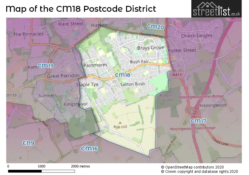
Map of the Postcode District
Explore the postcode district by using our interactive map.
Circles represent recorded crime; the larger the circle, the higher the crime rates.
Your support helps keep this site running!
If you enjoy using this website, consider buying me a coffee to help cover hosting costs.
The postcode district located in the CM Chelmsford postal area , CM18 has a population of 26,013 residents according to the 2021 England and Wales Census.
The area of the district is 3.08 square miles (7.98 square kilometers or 1,971.49 acres).
Where is the CM18 District?
To give you an idea where the district is located we have created the following table showing nearby towns.
Nearest Towns to CM18
| Town | Distance (miles) | Direction |
|---|---|---|
| Harlow | 1.31 | NNW |
| Epping | 3.66 | S |
| Sawbridgeworth | 4.63 | NNE |
| Hoddesdon | 5.16 | W |
| Waltham Abbey | 5.93 | SW |
| Chipping Ongar | 6.77 | ESE |
| Loughton | 6.80 | SSW |
| Cheshunt | 7.26 | WSW |
| Ware | 7.46 | NW |
| Waltham Cross | 7.54 | SW |
| Hertford | 8.50 | WNW |
| Bishop's Stortford | 8.57 | NNE |
| Chigwell | 9.20 | S |
| Stansted Mountfitchet | 11.17 | NNE |
| Brentwood | 12.38 | SE |
| Potters Bar | 13.49 | WSW |
| Great Dunmow | 13.77 | NE |
| Welwyn Garden City | 13.94 | WNW |
| Hatfield | 14.08 | W |
| Buntingford | 14.45 | NNW |
The post town for this district is HARLOW.
Postcode Information for District CM18 (Total Geographical Postcodes: 431)
Retail and Shopping in CM18
Street
Town
Locality
Number of Shops
Central Postcode
View on Google Maps
BUSH FAIR
HARLOW
35
CM18 6PA
View on Google Maps
STAPLE TYE
HARLOW
17
CM18 7PJ
View on Google Maps
PERRY ROAD
HARLOW
7
CM18 7NW
View on Google Maps
| Street | Town | Locality | Number of Shops | Central Postcode | View on Google Maps |
|---|---|---|---|---|---|
| BUSH FAIR | HARLOW | 35 | CM18 6PA | View on Google Maps | |
| STAPLE TYE | HARLOW | 17 | CM18 7PJ | View on Google Maps | |
| PERRY ROAD | HARLOW | 7 | CM18 7NW | View on Google Maps |
The primary settlement in the CM18 postcode district is Harlow, located in the county of Essex in England. Harlow is the most significant settlement in the district, with a count of 228. There is also another significant settlement in the district, also named Harlow, with a count of 203. Both settlements are part of the post town of Harlow in Essex.
When it comes to local government, postal geography often disregards political borders. However, this district intersects the following councils: the district mostly encompasses the Harlow District (429 postal codes), and finally, the Epping Forest District area (3 postal codes).
The CM18 postal code covers the settlement of HARLOW.
The CM18 Postcode shares a border with CM17 (HARLOW, Newhall, Matching Green), CM20 (HARLOW, Gilston) and CM16 (EPPING, NORTH WEALD BASSETT, THEYDON BOIS).


Schools in the Sector
St Mark's West Essex Catholic School
Phase: Secondary
Address: Tripton Road , Harlow
Postcode: CM18 6AA
Headteacher: Mr John Taylor (Headteacher)
Ofsted Rating: Good
Purford Green Primary School
Phase: Primary
Address: Purford Green , Harlow
Postcode: CM18 6HP
Headteacher: Ms Emma Bloomfield ()
Ofsted Rating: Good
Passmores Academy
Phase: Secondary
Address: Tracyes Road , Harlow
Postcode: CM18 6JH
Headteacher: Natalie Christie / Victor Goddard (Principal)
Ofsted Rating: Good
Holy Cross Catholic Primary School, Harlow
Phase: Primary
Address: Tracyes Road , Southern Way , Harlow
Postcode: CM18 6JJ
Headteacher: Mrs Alison Kerrell (Headteacher)
Ofsted Rating: Good
William Martin Church of England Voluntary Controlled Junior School, Harlow
Phase: Primary
Address: Tawneys Road , Harlow
Postcode: CM18 6PN
Headteacher: Janet Matthews (Headteacher)
Ofsted Rating: Good
William Martin CofE VC Infant and Nursery School, Harlow
Phase: Primary
Address: Tawneys Road , Harlow
Postcode: CM18 6PN
Headteacher: Mrs Janet Matthews (Headteacher)
Ofsted Rating: Good
William Martin Church of England Infant and Nursery School
Phase: Primary
Address: Tawneys Road , Harlow
Postcode: CM18 6PN
Headteacher: Mrs Gina Bailey (Headteacher)
Ofsted Rating: Good
William Martin Church of England Junior School
Phase: Primary
Address: Tawneys Road , Harlow
Postcode: CM18 6PN
Headteacher: Gina Bailey ()
Ofsted Rating: Good
Harlow Fields School and College
Phase: Not applicable
Address: Tendring Road , Harlow
Postcode: CM18 6RN
Headteacher: Ms Kathleen Faherty (Headteacher)
Ofsted Rating: Good
Abbotsweld Primary Academy
Phase: Primary
Address: Partridge Road , Harlow
Postcode: CM18 6TE
Headteacher: Mrs Katherine Benson (Executive Headteacher)
Ofsted Rating: Good
Pear Tree Mead Academy
Phase: Primary
Address: Pear Tree Mead , Harlow
Postcode: CM18 7BY
Headteacher: Mrs Christine Peden (Headteacher)
Ofsted Rating: Good
TBAP Aspire AP Academy
Phase: Not applicable
Address: Commonside Road , Harlow
Postcode: CM18 7EZ
Headteacher: Ms Deborah Garfield (Principal)
Ofsted Rating: Special Measures
Latton Green Primary Academy
Phase: Primary
Address: Riddings Lane , Harlow
Postcode: CM18 7HT
Headteacher: Miss Emily Allen (Executive Headteacher)
Ofsted Rating: Good
Stewards Academy - Science Specialist, Harlow
Phase: Secondary
Address: Parnall Road , Harlow
Postcode: CM18 7NQ
Headteacher: Mrs Helen Ginger (Headteacher)
Ofsted Rating: Good
Kingsmoor Academy
Phase: Primary
Address: Ployters Road , Harlow
Postcode: CM18 7PS
Headteacher: Ms Angela Lymbouris (Principal)
Ofsted Rating: Good
St James Church of England Primary School
Phase: Primary
Address: Paringdon Road , Harlow
Postcode: CM18 7RH
Headteacher: Mrs Gina Bailey ()
Ofsted Rating: Good
Longwood Primary Academy
Phase: Primary
Address: Paringdon Road , Harlow
Postcode: CM18 7RQ
Headteacher: Mrs Monica Holland (Executive Headteacher)
Ofsted Rating: Good
Stations in the Sector
No stations found in this postcode district.
Accessable Motorway Junctions
M11 J7
Average Driving Time from within the district: 3.92
Average Driving Distance: 2.29
Number of Postcodes that can access the Motorway Junction: 431
M11 J7A
Average Driving Time from within the district: 6.90
Average Driving Distance: 5.22
Number of Postcodes that can access the Motorway Junction: 431
M11 J6
Average Driving Time from within the district: 8.51
Average Driving Distance: 7.00
Number of Postcodes that can access the Motorway Junction: 431
M25 J27
Average Driving Time from within the district: 8.51
Average Driving Distance: 7.00
Number of Postcodes that can access the Motorway Junction: 431
M25 J26
Average Driving Time from within the district: 12.90
Average Driving Distance: 11.29
Number of Postcodes that can access the Motorway Junction: 431
Weather Forecast for Harlow
| Time Period | Icon | Description | Temperature | Rain Probability | Wind |
|---|---|---|---|---|---|
| 12:00 to 15:00 | Cloudy | 14.0°C (feels like 12.0°C) | 4.00% | SW 11 mph | |
| 15:00 to 18:00 | Cloudy | 15.0°C (feels like 14.0°C) | 5.00% | WSW 7 mph | |
| 18:00 to 21:00 | Clear night | 12.0°C (feels like 12.0°C) | 1.00% | SSW 4 mph | |
| 21:00 to 00:00 | Clear night | 10.0°C (feels like 10.0°C) | 0.00% | SW 2 mph |
| Time Period | Icon | Description | Temperature | Rain Probability | Wind |
|---|---|---|---|---|---|
| 00:00 to 03:00 | Partly cloudy (night) | 9.0°C (feels like 9.0°C) | 15.00% | SW 4 mph | |
| 03:00 to 06:00 | Fog | 9.0°C (feels like 8.0°C) | 17.00% | SSW 4 mph | |
| 06:00 to 09:00 | Fog | 9.0°C (feels like 8.0°C) | 18.00% | SSW 4 mph | |
| 09:00 to 12:00 | Fog | 11.0°C (feels like 10.0°C) | 15.00% | S 4 mph | |
| 12:00 to 15:00 | Cloudy | 14.0°C (feels like 13.0°C) | 6.00% | SSW 7 mph | |
| 15:00 to 18:00 | Partly cloudy (day) | 15.0°C (feels like 14.0°C) | 1.00% | S 7 mph | |
| 18:00 to 21:00 | Clear night | 12.0°C (feels like 11.0°C) | 0.00% | SSE 7 mph | |
| 21:00 to 00:00 | Clear night | 11.0°C (feels like 9.0°C) | 0.00% | SSE 7 mph |
| Time Period | Icon | Description | Temperature | Rain Probability | Wind |
|---|---|---|---|---|---|
| 00:00 to 03:00 | Clear night | 10.0°C (feels like 8.0°C) | 0.00% | SE 9 mph | |
| 03:00 to 06:00 | Clear night | 9.0°C (feels like 8.0°C) | 1.00% | SE 7 mph | |
| 06:00 to 09:00 | Clear night | 9.0°C (feels like 7.0°C) | 1.00% | SE 9 mph | |
| 09:00 to 12:00 | Sunny day | 12.0°C (feels like 10.0°C) | 2.00% | SSE 9 mph | |
| 12:00 to 15:00 | Partly cloudy (day) | 15.0°C (feels like 13.0°C) | 1.00% | SSE 13 mph | |
| 15:00 to 18:00 | Partly cloudy (day) | 16.0°C (feels like 14.0°C) | 1.00% | S 11 mph | |
| 18:00 to 21:00 | Clear night | 14.0°C (feels like 12.0°C) | 2.00% | SSE 9 mph | |
| 21:00 to 00:00 | Clear night | 14.0°C (feels like 12.0°C) | 4.00% | SSE 11 mph |
| Time Period | Icon | Description | Temperature | Rain Probability | Wind |
|---|---|---|---|---|---|
| 00:00 to 03:00 | Partly cloudy (night) | 14.0°C (feels like 12.0°C) | 15.00% | S 11 mph | |
| 03:00 to 06:00 | Light rain shower (night) | 13.0°C (feels like 11.0°C) | 36.00% | S 11 mph | |
| 06:00 to 09:00 | Cloudy | 12.0°C (feels like 10.0°C) | 12.00% | SSW 9 mph | |
| 09:00 to 12:00 | Partly cloudy (day) | 12.0°C (feels like 10.0°C) | 8.00% | SSW 11 mph | |
| 12:00 to 15:00 | Partly cloudy (day) | 13.0°C (feels like 11.0°C) | 10.00% | SSW 11 mph | |
| 15:00 to 18:00 | Partly cloudy (day) | 13.0°C (feels like 11.0°C) | 10.00% | SSW 11 mph | |
| 18:00 to 21:00 | Clear night | 11.0°C (feels like 8.0°C) | 4.00% | SSW 11 mph | |
| 21:00 to 00:00 | Clear night | 9.0°C (feels like 7.0°C) | 2.00% | SW 11 mph |
| Time Period | Icon | Description | Temperature | Rain Probability | Wind |
|---|---|---|---|---|---|
| 00:00 to 03:00 | Clear night | 8.0°C (feels like 6.0°C) | 1.00% | SW 9 mph | |
| 03:00 to 06:00 | Clear night | 8.0°C (feels like 5.0°C) | 2.00% | SW 9 mph | |
| 06:00 to 09:00 | Partly cloudy (night) | 8.0°C (feels like 5.0°C) | 3.00% | SSW 9 mph | |
| 09:00 to 12:00 | Sunny day | 10.0°C (feels like 7.0°C) | 8.00% | SW 11 mph | |
| 12:00 to 15:00 | Cloudy | 12.0°C (feels like 10.0°C) | 11.00% | SW 13 mph | |
| 15:00 to 18:00 | Cloudy | 12.0°C (feels like 10.0°C) | 13.00% | SW 11 mph | |
| 18:00 to 21:00 | Clear night | 11.0°C (feels like 9.0°C) | 10.00% | SW 11 mph | |
| 21:00 to 00:00 | Clear night | 10.0°C (feels like 8.0°C) | 6.00% | SW 11 mph |
| Postal Sector | Delivery Office |
|---|---|
| CM18 6 | Harlow Delivery Office |
| CM18 7 | Harlow Delivery Office |
| C | M | 1 | 8 | - | X | X | X |
| C | M | 1 | 8 | Space | Numeric | Letter | Letter |
Street List for the CM18 District
Current Monthly Rental Prices
| # Bedrooms | Min Price | Max Price | Avg Price |
|---|---|---|---|
| 1 | £950 | £950 | £950 |
| 2 | £1,300 | £1,400 | £1,342 |
| 3 | £1,800 | £1,800 | £1,800 |
Current House Prices
| # Bedrooms | Min Price | Max Price | Avg Price |
|---|---|---|---|
| 3 | £390,000 | £750,000 | £474,444 |
| 4 | £395,000 | £1,400,000 | £709,000 |
| 5 | £925,000 | £925,000 | £925,000 |
| 6 | £950,000 | £950,000 | £950,000 |
Estate Agents
| Logo | Name | Brand Name | Address | Contact Number |
|---|---|---|---|---|
 | Harlow | William H. Brown | 15 Broad Walk, Harlow, CM20 1HX | 01279 976892 |
 | Harlow | haart | 18 Broad Walk Harlow CM20 1HT | 01279 594748 |
 | Harlow | Fortune & Coates | Unit 16 Greenway Business Centre, Harlow Business Park, Essex, CM19 5QE | 01279 976912 |
 | Harlow | ReylandJohnson Estate Agents | 1 Acorn Mews, Harlow, Essex, CM18 6NA | 01279 594781 |
 | Harlow | Kings Group | Unit 4 Church Langley Way Church Langley Harlow CM17 9TE | 01279 969209 |
Yearly House Price Averages for the District
| Type of Property | 2018 Average | 2018 Sales | 2017 Average | 2017 Sales | 2016 Average | 2016 Sales | 2015 Average | 2015 Sales |
|---|---|---|---|---|---|---|---|---|
| Detached | £433,068 | 22 | £440,592 | 27 | £405,469 | 18 | £360,546 | 22 |
| Semi-Detached | £329,920 | 38 | £317,769 | 26 | £344,678 | 23 | £289,849 | 30 |
| Terraced | £264,564 | 187 | £274,146 | 209 | £245,532 | 211 | £217,492 | 217 |
| Flats | £166,574 | 54 | £168,874 | 69 | £156,835 | 79 | £123,726 | 65 |