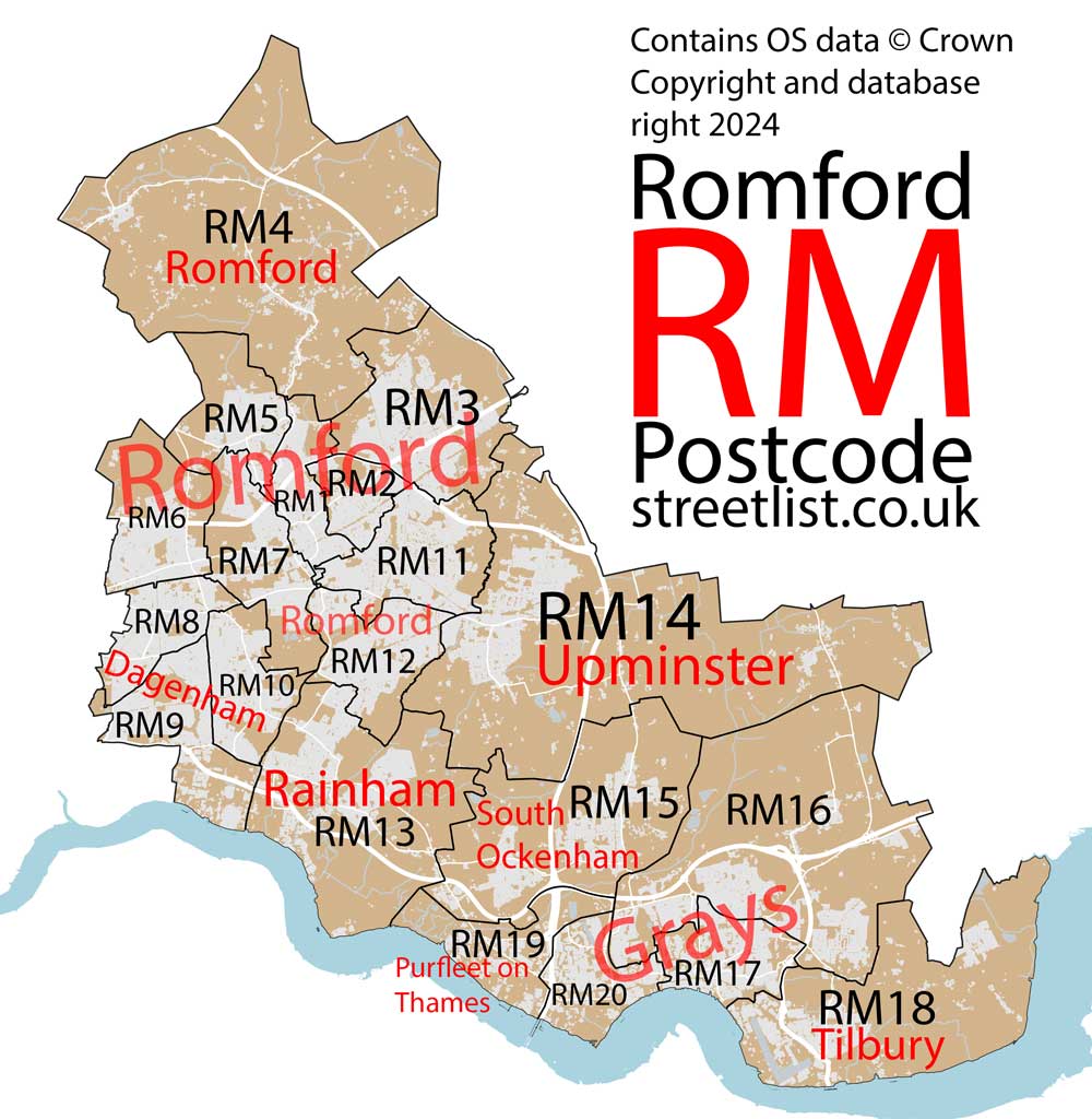
RM Postcode Area for the Romford Region
A wide range of spatial data has been analysed to present this overview. If you would like anything added, please contact us.
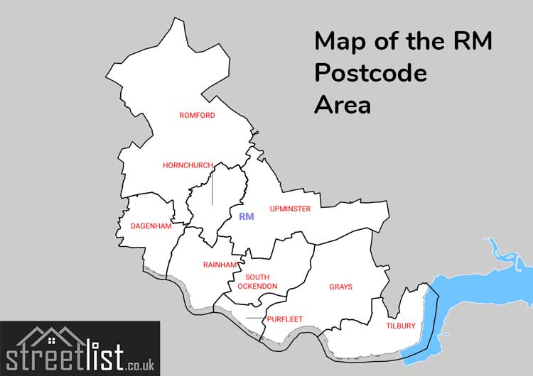
This section of the site is all about the RM Postcode area, also known as the Romford Postal Area. Explore links to the next level to learn more about specific postcode districts such as RM1.
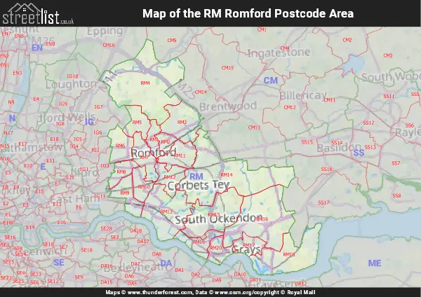
Map of the RM Romford Postcode Area
Explore the postcode area by using our interactive map.
Quick Facts about the RM Postcode
| Width from East to West | 15.35 mi |
| Height from North to South | 16.29 mi |
| Area of RM | 115.82 mi² |
| Maximum Width | 19.62 mi |
| Perimeter of Postcode Area | 77.34 mi |
| Number of Postcode Districts | 20 |
| Number of Postcode Sectors | 66 |
| Number of Post Towns | 9 |
| Number of Postcodes | 9,929 |
The RM postcode area represents a group of 20 postal districts in the Romford area of the United Kingdom. The area code stands for the letters r and m in RoMford. The area has a population of 516,824 and covers an area of 296,021 hectares. Fun fact: 0.80% of the population of Great Britain lives in this area.
The postcode area falls within the following counties: Greater London (75.12%), Essex (24.88%).
Post Towns and Postcode Districts
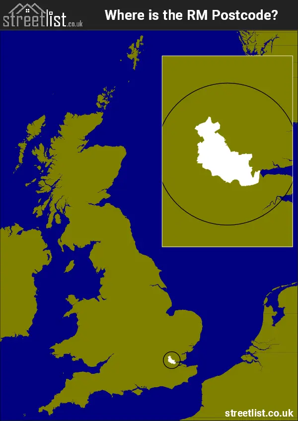
Where is the RM Postcode Area?
The RM Romford Postcode has it's North and South in Eastern England and it's mid Section in the London Region.. The postal area borders the following neighbouring postal areas: DA - Dartford, SS - Southend-on-Sea, CM - Chelmsford, SE - London - SE, IG - Ilford and ME - Medway, It also borders The Tidal Thames,
How built up is the Postcode Area?
I've calculated the total area covered by building footprints within the postcode area.
By analyzing this against the total area, I've determined the percentage of the area that's developed, this will give you an idea of how urban or rural the postcode region is.
The higher the percentage the more urban the area is. For example the least urban district is RM4 and the most urban is RM8.
| Postcode District | Total Area (m²) | Footprint Area (m²) | Built Percentage % |
|---|---|---|---|
| RM4 | 45,818,118 | 511,619 | 1.12% |
| RM14 | 47,164,634 | 1,457,215 | 3.09% |
| RM16 | 33,111,192 | 1,514,970 | 4.58% |
| RM15 | 21,508,991 | 1,076,018 | 5.00% |
| RM18 | 23,974,552 | 1,263,553 | 5.27% |
| RM13 | 22,293,398 | 1,501,550 | 6.74% |
| RM19 | 7,066,573 | 521,885 | 7.39% |
| RM5 | 7,247,936 | 663,194 | 9.15% |
| RM3 | 14,191,553 | 1,478,577 | 10.42% |
| RM6 | 8,405,609 | 957,007 | 11.39% |
| RM7 | 8,609,670 | 1,108,061 | 12.87% |
| RM2 | 3,428,210 | 527,004 | 15.37% |
| RM17 | 6,001,044 | 945,827 | 15.76% |
| RM11 | 8,973,235 | 1,439,016 | 16.04% |
| RM12 | 7,641,895 | 1,245,887 | 16.30% |
| RM9 | 8,479,863 | 1,448,585 | 17.08% |
| RM10 | 6,325,774 | 1,084,168 | 17.14% |
| RM20 | 5,828,673 | 1,076,273 | 18.47% |
| RM1 | 4,716,800 | 969,629 | 20.56% |
| RM8 | 5,231,725 | 1,130,753 | 21.61% |
| Total | 296,019,445 (m²) | 21,920,791 (m²) | 7.41% |
A map showing the boundary of RM in relation to other areas
There are 2 towns within the Romford postcode area.
| Unit | Area² |
|---|---|
| Hectares | 296,021² |
| Miles | 1,143² |
| Feet | 31,863,404,419² |
| Kilometres | 2,960² |
Postal Delivery Offices Serving the Postcode Area
- Dagenham Delivery Office
- Grays Delivery Office
- Harold Hill Delivery Office
- Hornchurch Delivery Office
- Rainham (rm) Delivery Office
- Romford Delivery Office
- South Ockendon Delivery Office
- Upminster Delivery Office
Tourist Attractions within the Area
We found 9 visitor attractions within the Romford postcode area
| Havering Museum |
|---|
| Museums & Art Galleries |
| Museum and / or Art Gallery |
| View Havering Museum on Google Maps |
| Rainham Hall |
| Historic Properties |
| Historic House / House and Garden / Palace |
| View Rainham Hall on Google Maps |
| St Andrew's Church |
| Places of Worship |
| Place of Worship (still in use) |
| View St Andrew's Church on Google Maps |
| St Andrew's Church |
| Places of Worship |
| Place of Worship (still in use) |
| View St Andrew's Church on Google Maps |
| Purfleet Heritage and Military Centre |
| Visitor Centres |
| Heritage / Visitor Centre |
| View Purfleet Heritage and Military Centre on Google Maps |
| Thames Chase Forest Centre |
| Country Parks |
| Country Park |
| View Thames Chase Forest Centre on Google Maps |
| Essex Fire Museum |
| Museums & Art Galleries |
| Museum and / or Art Gallery |
| View Essex Fire Museum on Google Maps |
| Tilbury Fort |
| Historic Properties |
| Castle / Fort |
| View Tilbury Fort on Google Maps |
| Coalhouse Fort |
| Historic Properties |
| Castle / Fort |
| View Coalhouse Fort on Google Maps |