The RM6 postcode district is a postal district located in the RM Romford postcode area with a population of 37,986 residents according to the 2021 England and Wales Census.
The area of the RM6 postcode district is 3.24 square miles which is 8.40 square kilometres or 2,076.53 acres.
Currently, the RM6 district has about 529 postcode units spread across 3 geographic postcode sectors.
Given that each sector allows for 400 unique postcode combinations, the district has a capacity of 1,200 postcodes. With 529 postcodes already in use, this leaves 671 units available.
The RM6 postal code covers the settlement of CHADWELL HEATH.
The RM6 Postcode shares a border with IG6 (HAINAULT, BARKINGSIDE, ILFORD), IG3 (SEVEN KINGS, GOODMAYES), RM7 (ROMFORD, RUSH GREEN) and RM8 (DAGENHAM).
In the RM6 postcode district, the primary settlement with the highest count is Romford, which is located in the county of Greater London. Other significant settlements in this district include Chadwell Heath and Little Heath. The most significant post town in the district is Romford.
For the district RM6, we have data on 3 postcode sectors. Here's a breakdown: The sector RM6 4, covers Romford and Chadwell Heath in Greater London. The sector RM6 5, covers Romford in Greater London. The sector RM6 6, covers Romford and Chadwell Heath in Greater London.

Map of the RM6 Postcode District
Explore the RM6 postcode district by using our free interactive map.
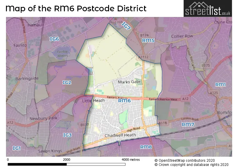
When it comes to local government, postal geography often disregards political borders. However, for a breakdown in the RM6 District: the district mostly encompasses the Redbridge London Boro (267 postcodes), and finally, the Barking and Dagenham London Boro area (263 postcodes).
Recent House Sales in RM6
| Date | Price | Address |
|---|---|---|
| 29/09/2023 | £290,000 | Birch Court, Chadwell Heath, Romford, RM6 4AP |
| 04/09/2023 | £300,000 | Crabtree Avenue, Romford, RM6 5EX |
| 25/08/2023 | £395,000 | Farrance Road, Romford, RM6 6EB |
| 25/08/2023 | £283,000 | Chadwell Heath Lane, Romford, RM6 4LS |
| 25/08/2023 | £360,000 | Bennett Road, Romford, RM6 6ER |
| 22/08/2023 | £435,000 | Heath Road, Romford, RM6 6LH |
| 21/08/2023 | £435,000 | Warren Terrace, Romford, RM6 5SB |
| 18/08/2023 | £485,000 | Putney Gardens, Chadwell Heath, Romford, RM6 4FF |
| 16/08/2023 | £480,000 | Cecil Road, Romford, RM6 6LA |
| 07/08/2023 | £560,000 | Portland Gardens, Romford, RM6 5UJ |
Weather Forecast for RM6
Press Button to Show Forecast for Romford
| Time Period | Icon | Description | Temperature | Rain Probability | Wind |
|---|---|---|---|---|---|
| 18:00 to 21:00 | Cloudy | 10.0°C (feels like 8.0°C) | 5.00% | E 9 mph | |
| 21:00 to 00:00 | Cloudy | 8.0°C (feels like 6.0°C) | 7.00% | ENE 9 mph |
Press Button to Show Forecast for Romford
| Time Period | Icon | Description | Temperature | Rain Probability | Wind |
|---|---|---|---|---|---|
| 00:00 to 03:00 | Overcast | 8.0°C (feels like 5.0°C) | 17.00% | ENE 9 mph | |
| 03:00 to 06:00 | Heavy rain | 7.0°C (feels like 4.0°C) | 81.00% | NE 9 mph | |
| 06:00 to 09:00 | Light rain | 7.0°C (feels like 4.0°C) | 56.00% | NE 9 mph | |
| 09:00 to 12:00 | Overcast | 8.0°C (feels like 6.0°C) | 14.00% | NE 9 mph | |
| 12:00 to 15:00 | Overcast | 11.0°C (feels like 10.0°C) | 16.00% | ENE 9 mph | |
| 15:00 to 18:00 | Cloudy | 12.0°C (feels like 11.0°C) | 9.00% | ENE 9 mph | |
| 18:00 to 21:00 | Light rain | 12.0°C (feels like 10.0°C) | 50.00% | ENE 9 mph | |
| 21:00 to 00:00 | Heavy rain | 10.0°C (feels like 7.0°C) | 86.00% | NE 11 mph |
Press Button to Show Forecast for Romford
| Time Period | Icon | Description | Temperature | Rain Probability | Wind |
|---|---|---|---|---|---|
| 00:00 to 03:00 | Heavy rain | 9.0°C (feels like 7.0°C) | 91.00% | NNE 11 mph | |
| 03:00 to 06:00 | Heavy rain | 9.0°C (feels like 7.0°C) | 93.00% | ENE 9 mph | |
| 06:00 to 09:00 | Heavy rain | 9.0°C (feels like 8.0°C) | 67.00% | ENE 7 mph | |
| 09:00 to 12:00 | Light rain | 10.0°C (feels like 8.0°C) | 59.00% | W 9 mph | |
| 12:00 to 15:00 | Light rain | 10.0°C (feels like 7.0°C) | 58.00% | W 13 mph | |
| 15:00 to 18:00 | Light rain | 10.0°C (feels like 8.0°C) | 46.00% | W 11 mph | |
| 18:00 to 21:00 | Cloudy | 11.0°C (feels like 9.0°C) | 9.00% | WSW 7 mph | |
| 21:00 to 00:00 | Clear night | 9.0°C (feels like 7.0°C) | 2.00% | SW 7 mph |
Press Button to Show Forecast for Romford
| Time Period | Icon | Description | Temperature | Rain Probability | Wind |
|---|---|---|---|---|---|
| 00:00 to 03:00 | Clear night | 8.0°C (feels like 6.0°C) | 2.00% | SW 4 mph | |
| 03:00 to 06:00 | Clear night | 6.0°C (feels like 5.0°C) | 1.00% | SSW 4 mph | |
| 06:00 to 09:00 | Sunny day | 7.0°C (feels like 6.0°C) | 2.00% | S 4 mph | |
| 09:00 to 12:00 | Sunny day | 12.0°C (feels like 10.0°C) | 2.00% | S 9 mph | |
| 12:00 to 15:00 | Partly cloudy (day) | 15.0°C (feels like 12.0°C) | 3.00% | S 11 mph | |
| 15:00 to 18:00 | Partly cloudy (day) | 15.0°C (feels like 13.0°C) | 2.00% | S 11 mph | |
| 18:00 to 21:00 | Sunny day | 14.0°C (feels like 12.0°C) | 1.00% | S 9 mph | |
| 21:00 to 00:00 | Clear night | 10.0°C (feels like 9.0°C) | 1.00% | SE 7 mph |
Press Button to Show Forecast for Romford
| Time Period | Icon | Description | Temperature | Rain Probability | Wind |
|---|---|---|---|---|---|
| 00:00 to 03:00 | Clear night | 9.0°C (feels like 7.0°C) | 1.00% | SE 7 mph | |
| 03:00 to 06:00 | Clear night | 8.0°C (feels like 7.0°C) | 2.00% | ESE 7 mph | |
| 06:00 to 09:00 | Cloudy | 9.0°C (feels like 8.0°C) | 7.00% | ESE 7 mph | |
| 09:00 to 12:00 | Cloudy | 14.0°C (feels like 12.0°C) | 6.00% | ESE 7 mph | |
| 12:00 to 15:00 | Cloudy | 16.0°C (feels like 14.0°C) | 8.00% | SE 9 mph | |
| 15:00 to 18:00 | Cloudy | 17.0°C (feels like 15.0°C) | 10.00% | SE 9 mph | |
| 18:00 to 21:00 | Cloudy | 15.0°C (feels like 14.0°C) | 15.00% | ESE 9 mph | |
| 21:00 to 00:00 | Cloudy | 12.0°C (feels like 11.0°C) | 13.00% | ESE 7 mph |
Where is the RM6 Postcode District?
The postcode district RM6 is located in Romford, which is a district town. Romford is near several other towns: Chadwell Heath, Newbury Park, Mawneys, Hainault, and Collier Row. Additionally, Romford is approximately 12.3 miles away from the center of London.
The district is within the post town of ROMFORD.
The sector has postcodes within the nation of England.
The RM6 Postcode District is covers the following regions.
- Redbridge and Waltham Forest - Outer London - East and North East - London
- Barking & Dagenham and Havering - Outer London - East and North East - London
| Postcode Sector | Delivery Office |
|---|---|
| RM6 4 | Romford Delivery Office |
| RM6 5 | Romford Delivery Office |
| RM6 6 | Romford Delivery Office |
| R | M | 6 | - | X | X | X |
| R | M | 6 | Space | Numeric | Letter | Letter |
Current Monthly Rental Prices
| # Bedrooms | Min Price | Max Price | Avg Price |
|---|---|---|---|
| 1 | £750 | £1,350 | £1,050 |
| 2 | £1,400 | £1,700 | £1,600 |
| 3 | £1,800 | £2,297 | £1,985 |
Current House Prices
| # Bedrooms | Min Price | Max Price | Avg Price |
|---|---|---|---|
| £25,000 | £185,000 | £80,000 | |
| 1 | £80,000 | £285,000 | £173,499 |
| 2 | £150,000 | £450,000 | £286,168 |
| 3 | £250,000 | £700,000 | £467,269 |
| 4 | £317,500 | £700,000 | £527,839 |
| 5 | £500,000 | £899,995 | £657,999 |
| 6 | £750,000 | £750,000 | £750,000 |
Estate Agents who Operate in the RM6 District
| Logo | Name | Brand Name | Address | Contact Number | Total Properties |
|---|---|---|---|---|---|
 | Chadwell Heath | Ashton Estate Agents | 1 High Road, Chadwell Heath, Romford, RM6 6PX | 020 3909 6750 | 36 |
 | Chadwell Heath | Douglas Allen | 1185 High Road Chadwell Heath Romford RM6 4AL | 020 3835 6376 | 22 |
 | Chadwell Heath | Brian Thomas Estate Agents | 1124 High Road Chadwell Heath Romford RM6 4AH | 020 3834 8651 | 17 |
 | Chadwell Heath | YOUR MOVE Glenwood | 35 High Road, Chadwell Heath, Romford, RM6 6QJ | 020 3870 5048 | 13 |
 | Chadwell Heath | Hunters | 6 Tudor Parade, High Road, Chadwell Heath, Romford, RM6 6PS | 020 3889 9037 | 10 |
| Type of Property | 2018 Average | 2018 Sales | 2017 Average | 2017 Sales | 2016 Average | 2016 Sales | 2015 Average | 2015 Sales |
|---|---|---|---|---|---|---|---|---|
| Detached | £716,097 | 7 | £465,625 | 8 | £414,375 | 8 | £346,050 | 10 |
| Semi-Detached | £395,223 | 65 | £407,770 | 73 | £373,156 | 72 | £317,814 | 80 |
| Terraced | £398,112 | 197 | £375,390 | 198 | £355,726 | 191 | £314,262 | 231 |
| Flats | £243,602 | 177 | £215,161 | 150 | £203,901 | 132 | £175,475 | 154 |