The RM7 postcode district is a postal district located in the RM Romford postcode area with a population of 32,686 residents according to the 2021 England and Wales Census.
The area of the RM7 postcode district is 3.32 square miles which is 8.61 square kilometres or 2,126.98 acres.
Currently, the RM7 district has about 586 postcode units spread across 4 geographic postcode sectors.
Given that each sector allows for 400 unique postcode combinations, the district has a capacity of 1,600 postcodes. With 586 postcodes already in use, this leaves 1014 units available.
The largest settlements in the RM7 postal code are ROMFORD and RUSH GREEN.
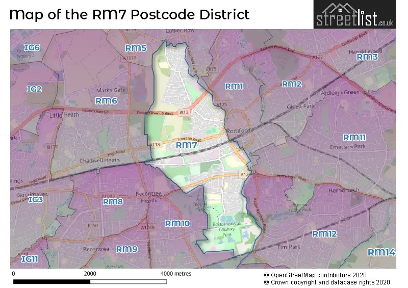
The RM7 Postcode shares a border with RM5 (ROMFORD), RM6 (CHADWELL HEATH), RM8 (DAGENHAM), RM10 (DAGENHAM), RM1 (ROMFORD) and RM12 (HORNCHURCH).
The primary settlement in the RM7 postcode district is Romford, located in the county of Greater London, England.
For the district RM7, we have data on 5 postcode sectors. Here's a breakdown: The sector RM7 0, covers Romford in Greater London. The sector RM7 1 is non-geographic. It's often designated for PO Boxes, large organisations, or special services. The sector RM7 7, covers Romford in Greater London. The sector RM7 8, covers Romford in Greater London. The sector RM7 9, covers Romford in Greater London.

Map of the RM7 Postcode District
Explore the RM7 postcode district by using our free interactive map.
When it comes to local government, postal geography often disregards political borders. However, for a breakdown in the RM7 District: the district mostly encompasses the Havering London Boro (508 postcodes), and finally, the Barking and Dagenham London Boro area (73 postcodes).
Recent House Sales in RM7
| Date | Price | Address |
|---|---|---|
| 02/10/2023 | £150,000 | White Hart Lane, Collier Row, Romford, RM7 8LZ |
| 29/09/2023 | £250,000 | Foxglove Road, Rush Green, Romford, RM7 0YW |
| 26/09/2023 | £205,000 | Linden Street, Romford, RM7 7DP |
| 25/09/2023 | £214,000 | Maxwell Road, Romford, RM7 0FF |
| 18/09/2023 | £185,000 | White Hart Lane, Collier Row, Romford, RM7 8LZ |
| 14/09/2023 | £460,000 | Jutsums Lane, Romford, RM7 9HJ |
| 11/09/2023 | £415,000 | Marks Road, Romford, RM7 7AF |
| 05/09/2023 | £430,000 | Pretoria Road, Romford, RM7 7AX |
| 01/09/2023 | £470,000 | Cross Road, Mawneys, Romford, RM7 8AU |
| 31/08/2023 | £360,000 | Dandelion Close, Rush Green, Romford, RM7 0YY |
Weather Forecast for RM7
Press Button to Show Forecast for Romford
| Time Period | Icon | Description | Temperature | Rain Probability | Wind |
|---|---|---|---|---|---|
| 00:00 to 03:00 | Cloudy | 6.0°C (feels like 4.0°C) | 5.00% | NE 7 mph | |
| 03:00 to 06:00 | Cloudy | 5.0°C (feels like 3.0°C) | 5.00% | NE 7 mph | |
| 06:00 to 09:00 | Cloudy | 5.0°C (feels like 2.0°C) | 4.00% | NE 7 mph | |
| 09:00 to 12:00 | Cloudy | 8.0°C (feels like 6.0°C) | 4.00% | ENE 7 mph | |
| 12:00 to 15:00 | Cloudy | 11.0°C (feels like 9.0°C) | 10.00% | E 7 mph | |
| 15:00 to 18:00 | Cloudy | 10.0°C (feels like 9.0°C) | 10.00% | E 7 mph | |
| 18:00 to 21:00 | Cloudy | 9.0°C (feels like 8.0°C) | 10.00% | E 7 mph | |
| 21:00 to 00:00 | Cloudy | 7.0°C (feels like 5.0°C) | 9.00% | E 7 mph |
Press Button to Show Forecast for Romford
| Time Period | Icon | Description | Temperature | Rain Probability | Wind |
|---|---|---|---|---|---|
| 00:00 to 03:00 | Cloudy | 5.0°C (feels like 3.0°C) | 12.00% | ENE 7 mph | |
| 03:00 to 06:00 | Cloudy | 5.0°C (feels like 3.0°C) | 17.00% | NE 7 mph | |
| 06:00 to 09:00 | Light rain | 6.0°C (feels like 4.0°C) | 47.00% | NE 7 mph | |
| 09:00 to 12:00 | Overcast | 10.0°C (feels like 8.0°C) | 20.00% | E 9 mph | |
| 12:00 to 15:00 | Cloudy | 12.0°C (feels like 10.0°C) | 16.00% | E 11 mph | |
| 15:00 to 18:00 | Cloudy | 12.0°C (feels like 10.0°C) | 18.00% | E 11 mph | |
| 18:00 to 21:00 | Light rain | 11.0°C (feels like 9.0°C) | 52.00% | ENE 9 mph | |
| 21:00 to 00:00 | Light rain | 10.0°C (feels like 7.0°C) | 52.00% | ENE 11 mph |
Press Button to Show Forecast for Romford
| Time Period | Icon | Description | Temperature | Rain Probability | Wind |
|---|---|---|---|---|---|
| 00:00 to 03:00 | Heavy rain | 9.0°C (feels like 7.0°C) | 73.00% | ENE 9 mph | |
| 03:00 to 06:00 | Heavy rain shower (night) | 10.0°C (feels like 8.0°C) | 60.00% | ESE 9 mph | |
| 06:00 to 09:00 | Light rain shower (day) | 10.0°C (feels like 8.0°C) | 39.00% | ESE 7 mph | |
| 09:00 to 12:00 | Light rain shower (day) | 11.0°C (feels like 9.0°C) | 40.00% | SE 9 mph | |
| 12:00 to 15:00 | Heavy rain shower (day) | 13.0°C (feels like 11.0°C) | 64.00% | S 11 mph | |
| 15:00 to 18:00 | Light rain shower (day) | 14.0°C (feels like 12.0°C) | 41.00% | SSW 11 mph | |
| 18:00 to 21:00 | Light rain shower (day) | 13.0°C (feels like 11.0°C) | 34.00% | WSW 11 mph | |
| 21:00 to 00:00 | Cloudy | 10.0°C (feels like 9.0°C) | 7.00% | SW 7 mph |
Where is the RM7 Postcode District?
The postcode district associated with RM7 is Romford. Romford is located in the northeastern part of London, with a distance of approximately 13.47 miles. It is surrounded by several nearby towns, including Mawneys to the north, Rush Green to the southeast, Gidea Park to the northeast, Hornchurch to the east, Chadwell Heath to the west, and Dagenham to the southwest.
The district is within the post town of ROMFORD.
The sector has postcodes within the nation of England.
The RM7 Postcode District is in the Barking & Dagenham and Havering region of Outer London - East and North East within the London.
| Postcode Sector | Delivery Office |
|---|---|
| RM7 7 | Romford Delivery Office |
| RM7 8 | Romford Delivery Office |
| RM7 9 | Romford Delivery Office |
| R | M | 7 | - | X | X | X |
| R | M | 7 | Space | Numeric | Letter | Letter |
Current Monthly Rental Prices
| # Bedrooms | Min Price | Max Price | Avg Price |
|---|---|---|---|
| 1 | £1,095 | £1,400 | £1,224 |
| 2 | £1,500 | £1,750 | £1,594 |
| 3 | £1,800 | £2,000 | £1,913 |
| 4 | £2,500 | £2,500 | £2,500 |
Current House Prices
| # Bedrooms | Min Price | Max Price | Avg Price |
|---|---|---|---|
| £50,000 | £700,000 | £367,500 | |
| 1 | £80,500 | £240,000 | £186,500 |
| 2 | £42,999 | £400,000 | £290,589 |
| 3 | £42,999 | £1,750,000 | £463,357 |
| 4 | £425,000 | £600,000 | £521,316 |
| 5 | £525,000 | £650,000 | £587,500 |
Estate Agents who Operate in the RM7 District
| Logo | Name | Brand Name | Address | Contact Number | Total Properties |
|---|---|---|---|---|---|
 | Romford | haart | 153/159 South Street Romford RM1 1PL | 01708 205780 | 20 |
 | covering Romford | Purplebricks | Suite 7 First Floor Cranmore Drive Shirley Solihull B90 4RZ | 020 3910 6289 | 10 |
 | at Gidea Park | Beresfords | 85 Main Road, Gidea Park, Romford, RM2 5EL | 01708 961741 | 10 |
 | Romford | Balgores | 5-6 Station Chambers, Victoria Road, Romford, RM1 2HU | 01708 204467 | 9 |
 | East Anglia | Yopa | Meridian House Wheatfield Way Hinckley LE10 1YG | 01270 447764 | 7 |
| Type of Property | 2018 Average | 2018 Sales | 2017 Average | 2017 Sales | 2016 Average | 2016 Sales | 2015 Average | 2015 Sales |
|---|---|---|---|---|---|---|---|---|
| Detached | £435,500 | 15 | £445,227 | 22 | £431,152 | 23 | £388,553 | 19 |
| Semi-Detached | £374,061 | 127 | £368,335 | 116 | £349,818 | 129 | £316,845 | 99 |
| Terraced | £355,078 | 210 | £361,912 | 224 | £329,538 | 184 | £282,910 | 205 |
| Flats | £231,509 | 146 | £224,685 | 137 | £214,093 | 204 | £197,010 | 381 |