The RM10 postcode district is a postal district located in the RM Romford postcode area with a population of 42,394 residents according to the 2021 England and Wales Census.
The area of the RM10 postcode district is 2.44 square miles which is 6.32 square kilometres or 1,562.75 acres.
Currently, the RM10 district has about 584 postcode units spread across 3 geographic postcode sectors.
Given that each sector allows for 400 unique postcode combinations, the district has a capacity of 1,200 postcodes. With 584 postcodes already in use, this leaves 616 units available.
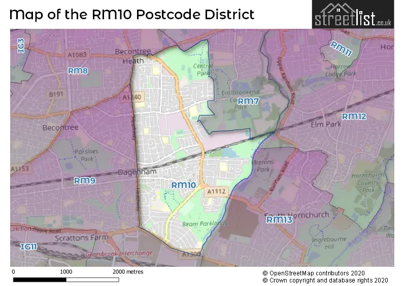
The RM10 postal code covers the settlement of DAGENHAM.
The RM10 Postcode shares a border with RM7 (ROMFORD, RUSH GREEN), RM8 (DAGENHAM), RM13 (RAINHAM), RM9 (DAGENHAM) and RM12 (HORNCHURCH).
The primary settlement in the RM10 postcode district is Dagenham, located in the county of Greater London. The most significant postal town in this postcode district is also Dagenham.
For the district RM10, we have data on 3 postcode sectors. Here's a breakdown: The sector RM10 7, covers Dagenham in Greater London. The sector RM10 8, covers Dagenham in Greater London. The sector RM10 9, covers Dagenham in Greater London.


Map of the RM10 Postcode District
Explore the RM10 postcode district by using our free interactive map.
When it comes to local government, postal geography often disregards political borders. However, for a breakdown in the RM10 District: the district mostly encompasses the Barking and Dagenham London Boro area with a total of 578 postcodes.
Recent House Sales in RM10
| Date | Price | Address |
|---|---|---|
| 29/09/2023 | £228,000 | Webbscroft Road, Dagenham, RM10 7NL |
| 15/09/2023 | £224,000 | Birdbrook Close, Dagenham, RM10 9XF |
| 15/09/2023 | £270,000 | Birdbrook Close, Dagenham, RM10 9XF |
| 08/09/2023 | £475,000 | Aldborough Road, Dagenham, RM10 8AT |
| 08/09/2023 | £525,000 | Aldborough Road, Dagenham, RM10 8AT |
| 31/08/2023 | £380,000 | Alibon Road, Dagenham, RM10 8DD |
| 30/08/2023 | £365,000 | Oval Road North, Dagenham, RM10 9ET |
| 25/08/2023 | £256,000 | School Road, Dagenham, RM10 9QL |
| 24/08/2023 | £365,000 | First Avenue, Dagenham, RM10 9AU |
| 18/08/2023 | £500,000 | Sterry Gardens, Dagenham, RM10 8PH |
Where is the RM10 Postcode District?
The postcode district RM10 is located in Dagenham, which is a town in the northeastern part of London. In close proximity to Dagenham, you will find Rush Green to the northeast, Elm Park to the east, Rainham to the southeast, Goodmayes to the northwest, Mawneys to the north, and Barking to the west. The distance between Dagenham and the center of London is approximately 12.712450545078715 miles.
The district is within the post town of DAGENHAM.
The sector has postcodes within the nation of England.
The RM10 Postcode District is in the Barking & Dagenham and Havering region of Outer London - East and North East within the London.
Weather Forecast for RM10
Press Button to Show Forecast for Dagenham
| Time Period | Icon | Description | Temperature | Rain Probability | Wind |
|---|---|---|---|---|---|
| 18:00 to 21:00 | Cloudy | 15.0°C (feels like 13.0°C) | 7.00% | SE 9 mph | |
| 21:00 to 00:00 | Cloudy | 14.0°C (feels like 12.0°C) | 7.00% | ESE 9 mph |
Press Button to Show Forecast for Dagenham
| Time Period | Icon | Description | Temperature | Rain Probability | Wind |
|---|---|---|---|---|---|
| 00:00 to 03:00 | Cloudy | 14.0°C (feels like 13.0°C) | 9.00% | ESE 7 mph | |
| 03:00 to 06:00 | Light rain | 13.0°C (feels like 13.0°C) | 48.00% | ESE 7 mph | |
| 06:00 to 09:00 | Cloudy | 14.0°C (feels like 13.0°C) | 11.00% | SE 4 mph | |
| 09:00 to 12:00 | Cloudy | 15.0°C (feels like 15.0°C) | 11.00% | SE 4 mph | |
| 12:00 to 15:00 | Light rain | 17.0°C (feels like 16.0°C) | 54.00% | ESE 7 mph | |
| 15:00 to 18:00 | Cloudy | 17.0°C (feels like 16.0°C) | 14.00% | SE 7 mph | |
| 18:00 to 21:00 | Cloudy | 17.0°C (feels like 16.0°C) | 13.00% | ESE 7 mph | |
| 21:00 to 00:00 | Cloudy | 14.0°C (feels like 14.0°C) | 9.00% | ESE 4 mph |
Press Button to Show Forecast for Dagenham
| Time Period | Icon | Description | Temperature | Rain Probability | Wind |
|---|---|---|---|---|---|
| 00:00 to 03:00 | Cloudy | 13.0°C (feels like 13.0°C) | 5.00% | SSE 4 mph | |
| 03:00 to 06:00 | Cloudy | 12.0°C (feels like 11.0°C) | 6.00% | SSE 2 mph | |
| 06:00 to 09:00 | Cloudy | 13.0°C (feels like 13.0°C) | 12.00% | SE 2 mph | |
| 09:00 to 12:00 | Cloudy | 16.0°C (feels like 16.0°C) | 11.00% | S 2 mph | |
| 12:00 to 15:00 | Cloudy | 18.0°C (feels like 18.0°C) | 12.00% | S 4 mph | |
| 15:00 to 18:00 | Cloudy | 18.0°C (feels like 17.0°C) | 14.00% | S 4 mph | |
| 18:00 to 21:00 | Cloudy | 17.0°C (feels like 17.0°C) | 14.00% | S 4 mph | |
| 21:00 to 00:00 | Cloudy | 15.0°C (feels like 14.0°C) | 13.00% | SW 4 mph |
Press Button to Show Forecast for Dagenham
| Time Period | Icon | Description | Temperature | Rain Probability | Wind |
|---|---|---|---|---|---|
| 00:00 to 03:00 | Partly cloudy (night) | 14.0°C (feels like 13.0°C) | 8.00% | WSW 4 mph | |
| 03:00 to 06:00 | Cloudy | 12.0°C (feels like 12.0°C) | 7.00% | WSW 4 mph | |
| 06:00 to 09:00 | Partly cloudy (day) | 13.0°C (feels like 12.0°C) | 8.00% | WSW 4 mph | |
| 09:00 to 12:00 | Partly cloudy (day) | 16.0°C (feels like 16.0°C) | 11.00% | WSW 4 mph | |
| 12:00 to 15:00 | Cloudy | 19.0°C (feels like 18.0°C) | 17.00% | W 7 mph | |
| 15:00 to 18:00 | Light rain shower (day) | 19.0°C (feels like 18.0°C) | 38.00% | WSW 7 mph | |
| 18:00 to 21:00 | Light rain shower (day) | 19.0°C (feels like 18.0°C) | 36.00% | WNW 4 mph | |
| 21:00 to 00:00 | Cloudy | 16.0°C (feels like 15.0°C) | 15.00% | WSW 4 mph |
Press Button to Show Forecast for Dagenham
| Time Period | Icon | Description | Temperature | Rain Probability | Wind |
|---|---|---|---|---|---|
| 00:00 to 03:00 | Cloudy | 14.0°C (feels like 14.0°C) | 9.00% | W 4 mph | |
| 03:00 to 06:00 | Cloudy | 13.0°C (feels like 12.0°C) | 12.00% | W 4 mph | |
| 06:00 to 09:00 | Cloudy | 13.0°C (feels like 12.0°C) | 11.00% | WNW 4 mph | |
| 09:00 to 12:00 | Cloudy | 15.0°C (feels like 15.0°C) | 12.00% | NW 4 mph | |
| 12:00 to 15:00 | Cloudy | 18.0°C (feels like 17.0°C) | 15.00% | NW 7 mph | |
| 15:00 to 18:00 | Light rain shower (day) | 19.0°C (feels like 18.0°C) | 36.00% | NNW 7 mph | |
| 18:00 to 21:00 | Light rain shower (day) | 18.0°C (feels like 17.0°C) | 35.00% | N 7 mph | |
| 21:00 to 00:00 | Clear night | 15.0°C (feels like 15.0°C) | 8.00% | NNW 7 mph |
| Postcode Sector | Delivery Office |
|---|---|
| RM10 7 | Dagenham Delivery Office |
| RM10 8 | Dagenham Delivery Office |
| RM10 9 | Dagenham Delivery Office |
| R | M | 1 | 0 | - | X | X | X |
| R | M | 1 | 0 | Space | Numeric | Letter | Letter |
Current Monthly Rental Prices
| # Bedrooms | Min Price | Max Price | Avg Price |
|---|---|---|---|
| 1 | £700 | £1,350 | £1,180 |
| 2 | £1,500 | £1,850 | £1,675 |
| 3 | £1,850 | £2,000 | £1,929 |
Current House Prices
| # Bedrooms | Min Price | Max Price | Avg Price |
|---|---|---|---|
| £160,000 | £160,000 | £160,000 | |
| 1 | £160,000 | £230,000 | £194,000 |
| 2 | £175,000 | £475,000 | £322,813 |
| 3 | £200,000 | £595,000 | £385,170 |
| 4 | £450,000 | £650,000 | £516,667 |
| 5 | £500,000 | £550,000 | £528,333 |
| 8 | £375,000 | £375,000 | £375,000 |
Estate Agents who Operate in the RM10 District
| Logo | Name | Brand Name | Address | Contact Number | Total Properties |
|---|---|---|---|---|---|
 | Dagenham | haart | 1-3a Reede Road, Dagenham, RM10 8DP | 020 3840 3397 | 18 |
 | Dagenham - Sales | Balgores | 293 Heathway, Dagenham, RM9 5AQ | 020 3840 3906 | 9 |
 | Dagenham | Bairstow Eves | 252 Heathway, Dagenham, Essex, RM10 8QS | 020 3866 8895 | 7 |
 | Dagenham | Ramsey Moore | 294 Heathway, Dagenham, RM10 8LU | 020 3908 8542 | 7 |
 | Dagenham | Carter & Willow | 482 Gale Street, Dagenham, RM9 4NU | 020 3840 3516 | 6 |
Yearly House Price Averages for the RM10 Postcode District
| Type of Property | 2018 Average | 2018 Sales | 2017 Average | 2017 Sales | 2016 Average | 2016 Sales | 2015 Average | 2015 Sales |
|---|---|---|---|---|---|---|---|---|
| Detached | £409,500 | 2 | £385,499 | 6 | £395,749 | 4 | £338,063 | 8 |
| Semi-Detached | £330,852 | 71 | £324,548 | 63 | £308,430 | 61 | £271,082 | 61 |
| Terraced | £309,059 | 258 | £304,195 | 303 | £292,554 | 287 | £248,592 | 302 |
| Flats | £203,315 | 85 | £194,197 | 104 | £184,961 | 105 | £152,116 | 129 |