The RM12 postcode district is a postal district located in the RM Romford postcode area with a population of 36,032 residents according to the 2021 England and Wales Census.
The area of the RM12 postcode district is 2.95 square miles which is 7.64 square kilometres or 1,887.93 acres.
Currently, the RM12 district has about 612 postcode units spread across 3 geographic postcode sectors.
Given that each sector allows for 400 unique postcode combinations, the district has a capacity of 1,200 postcodes. With 612 postcodes already in use, this leaves 588 units available.
The RM12 postal code covers the settlement of HORNCHURCH.
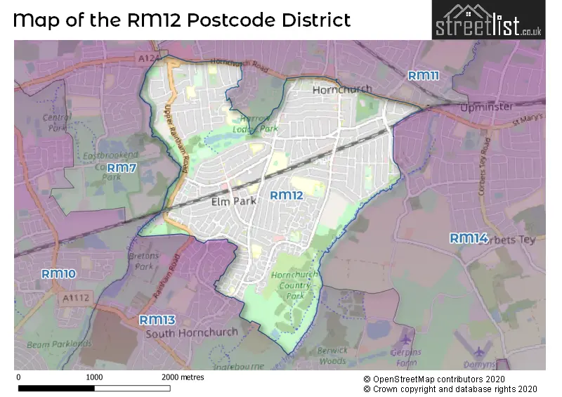
The RM12 Postcode shares a border with RM7 (ROMFORD, RUSH GREEN), RM13 (RAINHAM), RM10 (DAGENHAM), RM1 (ROMFORD), RM11 (HORNCHURCH) and RM14 (UPMINSTER, Bulphan, NORTH OCKENDON).
The primary settlement in the RM12 postcode district is Hornchurch, located in Greater London. It is the most significant settlement in the district, with a count of 253. There is also an additional settlement called Elm Park, which is part of Hornchurch. The county of Hornchurch is Greater London. The most significant post town in the district is also Hornchurch.
For the district RM12, we have data on 4 postcode sectors. Here's a breakdown: The sector RM12 4, covers Hornchurch in Greater London. The sector RM12 5, covers Hornchurch in Greater London. The sector RM12 6, covers Hornchurch in Greater London. The sector RM12 9 is non-geographic. It's often designated for PO Boxes, large organisations, or special services.

Map of the RM12 Postcode District
Explore the RM12 postcode district by using our free interactive map.
When it comes to local government, postal geography often disregards political borders. However, for a breakdown in the RM12 District: the district mostly encompasses the Havering London Boro area with a total of 627 postcodes.
Recent House Sales in RM12
| Date | Price | Address |
|---|---|---|
| 02/10/2023 | £268,000 | Bevan Way, Hornchurch, RM12 6EJ |
| 02/10/2023 | £390,000 | Harvard Walk, Hornchurch, RM12 4BB |
| 29/09/2023 | £510,000 | Elms Farm Road, Hornchurch, RM12 5RD |
| 15/09/2023 | £420,000 | Elm Park Avenue, Elm Park, Hornchurch, RM12 4PQ |
| 11/09/2023 | £470,000 | Warren Drive, Hornchurch, RM12 4QZ |
| 09/09/2023 | £505,000 | Dorian Road, Hornchurch, RM12 4AN |
| 06/09/2023 | £610,000 | Calbourne Avenue, Hornchurch, RM12 5BH |
| 01/09/2023 | £443,000 | Tangmere Crescent, Hornchurch, RM12 5PX |
| 01/09/2023 | £450,000 | Upper Rainham Road, Hornchurch, RM12 4DB |
| 01/09/2023 | £415,000 | Tennyson Way, Hornchurch, RM12 4BU |
Where is the RM12 Postcode District?
The data suggests that the postcode district RM12 is located in Hornchurch, a town in the London Borough of Havering. Hornchurch is situated in close proximity to several nearby towns, including Elm Park, Rush Green, Rainham, Emerson Park, Gidea Park, Upminster, and Mawneys. Furthermore, the district is approximately 14.7 miles away from the center of London.
The district is within the post town of HORNCHURCH.
The sector has postcodes within the nation of England.
The RM12 Postcode District is in the Barking & Dagenham and Havering region of Outer London - East and North East within the London.
Weather Forecast for RM12
Press Button to Show Forecast for Romford
| Time Period | Icon | Description | Temperature | Rain Probability | Wind |
|---|---|---|---|---|---|
| 09:00 to 12:00 | Heavy rain | 14.0°C (feels like 13.0°C) | 91.00% | S 7 mph | |
| 12:00 to 15:00 | Light rain | 14.0°C (feels like 13.0°C) | 91.00% | SSE 7 mph | |
| 15:00 to 18:00 | Cloudy | 16.0°C (feels like 14.0°C) | 17.00% | SSE 9 mph | |
| 18:00 to 21:00 | Cloudy | 15.0°C (feels like 13.0°C) | 8.00% | SE 9 mph | |
| 21:00 to 00:00 | Cloudy | 14.0°C (feels like 12.0°C) | 5.00% | ESE 9 mph |
Press Button to Show Forecast for Romford
| Time Period | Icon | Description | Temperature | Rain Probability | Wind |
|---|---|---|---|---|---|
| 00:00 to 03:00 | Cloudy | 14.0°C (feels like 12.0°C) | 10.00% | ESE 7 mph | |
| 03:00 to 06:00 | Cloudy | 13.0°C (feels like 12.0°C) | 13.00% | ESE 7 mph | |
| 06:00 to 09:00 | Cloudy | 14.0°C (feels like 13.0°C) | 9.00% | ESE 4 mph | |
| 09:00 to 12:00 | Cloudy | 15.0°C (feels like 15.0°C) | 15.00% | SE 4 mph | |
| 12:00 to 15:00 | Cloudy | 17.0°C (feels like 16.0°C) | 16.00% | ESE 4 mph | |
| 15:00 to 18:00 | Cloudy | 17.0°C (feels like 16.0°C) | 15.00% | SE 7 mph | |
| 18:00 to 21:00 | Cloudy | 16.0°C (feels like 16.0°C) | 15.00% | ESE 7 mph | |
| 21:00 to 00:00 | Cloudy | 14.0°C (feels like 13.0°C) | 11.00% | SE 4 mph |
Press Button to Show Forecast for Romford
| Time Period | Icon | Description | Temperature | Rain Probability | Wind |
|---|---|---|---|---|---|
| 00:00 to 03:00 | Cloudy | 13.0°C (feels like 12.0°C) | 6.00% | SE 2 mph | |
| 03:00 to 06:00 | Cloudy | 11.0°C (feels like 11.0°C) | 8.00% | SSE 2 mph | |
| 06:00 to 09:00 | Cloudy | 12.0°C (feels like 12.0°C) | 13.00% | SE 2 mph | |
| 09:00 to 12:00 | Cloudy | 16.0°C (feels like 16.0°C) | 14.00% | S 2 mph | |
| 12:00 to 15:00 | Cloudy | 18.0°C (feels like 18.0°C) | 12.00% | SSW 4 mph | |
| 15:00 to 18:00 | Cloudy | 18.0°C (feels like 17.0°C) | 14.00% | SSW 4 mph | |
| 18:00 to 21:00 | Cloudy | 17.0°C (feels like 17.0°C) | 17.00% | SSW 4 mph | |
| 21:00 to 00:00 | Cloudy | 14.0°C (feels like 14.0°C) | 11.00% | SW 4 mph |
Press Button to Show Forecast for Romford
| Time Period | Icon | Description | Temperature | Rain Probability | Wind |
|---|---|---|---|---|---|
| 00:00 to 03:00 | Clear night | 13.0°C (feels like 12.0°C) | 6.00% | WSW 4 mph | |
| 03:00 to 06:00 | Cloudy | 12.0°C (feels like 11.0°C) | 9.00% | WSW 4 mph | |
| 06:00 to 09:00 | Partly cloudy (day) | 13.0°C (feels like 12.0°C) | 9.00% | WSW 4 mph | |
| 09:00 to 12:00 | Partly cloudy (day) | 16.0°C (feels like 16.0°C) | 14.00% | WSW 4 mph | |
| 12:00 to 15:00 | Light rain shower (day) | 19.0°C (feels like 18.0°C) | 36.00% | W 7 mph | |
| 15:00 to 18:00 | Light rain shower (day) | 19.0°C (feels like 18.0°C) | 37.00% | W 7 mph | |
| 18:00 to 21:00 | Light rain shower (day) | 18.0°C (feels like 18.0°C) | 35.00% | WNW 4 mph | |
| 21:00 to 00:00 | Cloudy | 15.0°C (feels like 14.0°C) | 9.00% | W 4 mph |
Press Button to Show Forecast for Romford
| Time Period | Icon | Description | Temperature | Rain Probability | Wind |
|---|---|---|---|---|---|
| 00:00 to 03:00 | Cloudy | 13.0°C (feels like 13.0°C) | 9.00% | WNW 4 mph | |
| 03:00 to 06:00 | Cloudy | 12.0°C (feels like 11.0°C) | 10.00% | WNW 4 mph | |
| 06:00 to 09:00 | Cloudy | 13.0°C (feels like 12.0°C) | 11.00% | NW 4 mph | |
| 09:00 to 12:00 | Cloudy | 16.0°C (feels like 15.0°C) | 11.00% | NNW 7 mph | |
| 12:00 to 15:00 | Light rain shower (day) | 18.0°C (feels like 17.0°C) | 34.00% | NW 7 mph | |
| 15:00 to 18:00 | Light rain shower (day) | 18.0°C (feels like 17.0°C) | 37.00% | NW 9 mph | |
| 18:00 to 21:00 | Light rain shower (day) | 17.0°C (feels like 16.0°C) | 33.00% | NNW 7 mph | |
| 21:00 to 00:00 | Clear night | 14.0°C (feels like 13.0°C) | 6.00% | NNE 7 mph |
| Postcode Sector | Delivery Office |
|---|---|
| RM12 4 | Hornchurch Delivery Office |
| RM12 5 | Hornchurch Delivery Office |
| RM12 6 | Hornchurch Delivery Office |
| R | M | 1 | 2 | - | X | X | X |
| R | M | 1 | 2 | Space | Numeric | Letter | Letter |
Tourist Attractions within the RM12 Postcode Area
We found 2 visitor attractions within the RM12 postcode area
| St Andrew's Church |
|---|
| Places of Worship |
| Place of Worship (still in use) |
| View St Andrew's Church on Google Maps |
| St Andrew's Church |
| Places of Worship |
| Place of Worship (still in use) |
| View St Andrew's Church on Google Maps |
Current Monthly Rental Prices
| # Bedrooms | Min Price | Max Price | Avg Price |
|---|---|---|---|
| £1,300 | £1,300 | £1,300 | |
| 1 | £1,300 | £1,300 | £1,300 |
| 2 | £1,400 | £1,800 | £1,606 |
| 3 | £1,850 | £2,383 | £2,130 |
| 4 | £2,000 | £2,200 | £2,100 |
| 5 | £2,200 | £2,200 | £2,200 |
Current House Prices
| # Bedrooms | Min Price | Max Price | Avg Price |
|---|---|---|---|
| £750,000 | £750,000 | £750,000 | |
| 1 | £150,000 | £340,000 | £217,200 |
| 2 | £175,000 | £650,000 | £369,833 |
| 3 | £325,000 | £750,000 | £472,549 |
| 4 | £450,000 | £875,000 | £601,900 |
| 5 | £396,500 | £850,000 | £663,500 |
| 6 | £550,000 | £1,350,000 | £831,250 |
| 7 | £800,000 | £800,000 | £800,000 |
Estate Agents who Operate in the RM12 District
| Logo | Name | Brand Name | Address | Contact Number | Total Properties |
|---|---|---|---|---|---|
 | at Hornchurch | Beresfords | 135 High Street Hornchurch RM11 3YD | 01708 973553 | 25 |
 | Havering | Chalk Street Estates | 63-65 Station Lane, Hornchurch, Greater London, RM12 6JU | 01708 203145 | 17 |
 | Elm Park - Sales | Readings Property Services | 12 Elm Parade Shops St. Nicholas Avenue Elm Park Hornchurch RM12 4RH | 01708 984149 | 16 |
 | Hornchurch | Douglas Allen | 133A High Street, Hornchurch, Essex, RM11 1TX | 01708 205425 | 14 |
 | Hornchurch | Balgores | 1 North Street, Hornchurch, RM11 1RL | 01708 204755 | 12 |
Yearly House Price Averages for the RM12 Postcode District
| Type of Property | 2018 Average | 2018 Sales | 2017 Average | 2017 Sales | 2016 Average | 2016 Sales | 2015 Average | 2015 Sales |
|---|---|---|---|---|---|---|---|---|
| Detached | £512,438 | 24 | £554,417 | 18 | £469,618 | 25 | £402,568 | 28 |
| Semi-Detached | £430,837 | 202 | £421,897 | 221 | £399,355 | 205 | £346,734 | 209 |
| Terraced | £372,326 | 179 | £360,701 | 178 | £346,284 | 166 | £292,225 | 187 |
| Flats | £225,500 | 60 | £232,451 | 73 | £210,523 | 100 | £196,992 | 111 |