The RM19 postcode district is a postal district located in the RM Romford postcode area with a population of 7,356 residents according to the 2021 England and Wales Census.
The area of the RM19 postcode district is 2.73 square miles which is 7.07 square kilometres or 1,745.86 acres.
Currently, the RM19 district has about 143 postcode units spread across 1 geographic postcode sectors.
Given that each sector allows for 400 unique postcode combinations, the district has a capacity of 400 postcodes. With 143 postcodes already in use, this leaves 257 units available.
The RM19 postal code covers the settlement of PURFLEET.
The postcode area has a boundary with Tidal Thames.
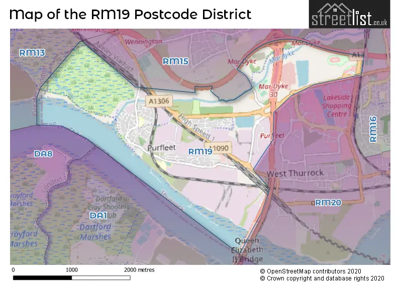
The RM19 Postcode shares a border with RM15 (SOUTH OCKENDON, AVELEY).
In the RM19 postcode district in Essex, the primary settlement is Purfleet-on-Thames, which accounts for the majority of the postcode. There are no other significant settlements or post towns mentioned in the given data.
For the district RM19, we have data on 1 postcode sectors. Here's a breakdown: The sector RM19 1, covers Purfleet-On-Thames in Essex.
RM19 Postcode Sectors

Map of the RM19 Postcode District
Explore the RM19 postcode district by using our free interactive map.
When it comes to local government, postal geography often disregards political borders. However, for a breakdown in the RM19 District: the district mostly encompasses the Thurrock (B) area with a total of 141 postcodes.
Recent House Sales in RM19
| Date | Price | Address |
|---|---|---|
| 25/08/2023 | £260,000 | Water Lane, Purfleet-on-thames, RM19 1GX |
| 23/08/2023 | £435,000 | North Road, Purfleet-on-thames, RM19 1TU |
| 18/08/2023 | £230,000 | Kendal, Purfleet-on-thames, RM19 1LL |
| 17/08/2023 | £210,000 | Windermere Avenue, Purfleet-on-thames, RM19 1RH |
| 31/07/2023 | £47,000,000 | Arterial Road, Purfleet-on-thames, RM19 1AE |
| 21/07/2023 | £220,000 | Caspian Way, Purfleet-on-thames, RM19 1LF |
| 21/07/2023 | £390,000 | Wood Avenue, Purfleet-on-thames, RM19 1TL |
| 18/07/2023 | £185,000 | Kendal, Purfleet-on-thames, RM19 1LL |
| 18/07/2023 | £310,500 | Water Lane, Purfleet-on-thames, RM19 1GT |
| 18/07/2023 | £293,000 | Botany Terrace, Purfleet-on-thames, RM19 1QR |
Weather Forecast for RM19
Press Button to Show Forecast for Dartford
| Time Period | Icon | Description | Temperature | Rain Probability | Wind |
|---|---|---|---|---|---|
| 00:00 to 03:00 | Light rain | 8.0°C (feels like 6.0°C) | 55.00% | ENE 9 mph | |
| 03:00 to 06:00 | Heavy rain | 7.0°C (feels like 5.0°C) | 82.00% | NE 9 mph | |
| 06:00 to 09:00 | Heavy rain | 7.0°C (feels like 4.0°C) | 75.00% | NE 9 mph | |
| 09:00 to 12:00 | Cloudy | 8.0°C (feels like 6.0°C) | 13.00% | NE 9 mph | |
| 12:00 to 15:00 | Cloudy | 12.0°C (feels like 10.0°C) | 50.00% | NE 7 mph | |
| 15:00 to 18:00 | Cloudy | 13.0°C (feels like 11.0°C) | 11.00% | ENE 9 mph | |
| 18:00 to 21:00 | Heavy rain | 12.0°C (feels like 10.0°C) | 76.00% | ENE 9 mph | |
| 21:00 to 00:00 | Heavy rain | 10.0°C (feels like 8.0°C) | 88.00% | NE 11 mph |
Press Button to Show Forecast for Dartford
| Time Period | Icon | Description | Temperature | Rain Probability | Wind |
|---|---|---|---|---|---|
| 00:00 to 03:00 | Heavy rain | 9.0°C (feels like 7.0°C) | 90.00% | NE 11 mph | |
| 03:00 to 06:00 | Heavy rain | 9.0°C (feels like 7.0°C) | 88.00% | NNE 9 mph | |
| 06:00 to 09:00 | Heavy rain | 9.0°C (feels like 8.0°C) | 86.00% | NE 7 mph | |
| 09:00 to 12:00 | Heavy rain | 10.0°C (feels like 8.0°C) | 80.00% | WNW 9 mph | |
| 12:00 to 15:00 | Heavy rain shower (day) | 10.0°C (feels like 8.0°C) | 61.00% | W 11 mph | |
| 15:00 to 18:00 | Light rain | 11.0°C (feels like 9.0°C) | 46.00% | W 11 mph | |
| 18:00 to 21:00 | Cloudy | 11.0°C (feels like 10.0°C) | 10.00% | WSW 9 mph | |
| 21:00 to 00:00 | Partly cloudy (night) | 10.0°C (feels like 8.0°C) | 6.00% | SW 7 mph |
Press Button to Show Forecast for Dartford
| Time Period | Icon | Description | Temperature | Rain Probability | Wind |
|---|---|---|---|---|---|
| 00:00 to 03:00 | Clear night | 8.0°C (feels like 7.0°C) | 2.00% | SW 4 mph | |
| 03:00 to 06:00 | Clear night | 7.0°C (feels like 6.0°C) | 1.00% | SSW 4 mph | |
| 06:00 to 09:00 | Sunny day | 8.0°C (feels like 6.0°C) | 1.00% | S 4 mph | |
| 09:00 to 12:00 | Partly cloudy (day) | 12.0°C (feels like 10.0°C) | 3.00% | S 9 mph | |
| 12:00 to 15:00 | Cloudy | 15.0°C (feels like 12.0°C) | 8.00% | S 11 mph | |
| 15:00 to 18:00 | Partly cloudy (day) | 15.0°C (feels like 13.0°C) | 2.00% | S 11 mph | |
| 18:00 to 21:00 | Sunny day | 14.0°C (feels like 12.0°C) | 2.00% | S 9 mph | |
| 21:00 to 00:00 | Clear night | 11.0°C (feels like 10.0°C) | 1.00% | SSE 7 mph |
Press Button to Show Forecast for Dartford
| Time Period | Icon | Description | Temperature | Rain Probability | Wind |
|---|---|---|---|---|---|
| 00:00 to 03:00 | Clear night | 10.0°C (feels like 8.0°C) | 2.00% | SE 7 mph | |
| 03:00 to 06:00 | Clear night | 9.0°C (feels like 8.0°C) | 3.00% | ESE 7 mph | |
| 06:00 to 09:00 | Cloudy | 10.0°C (feels like 8.0°C) | 8.00% | ESE 7 mph | |
| 09:00 to 12:00 | Partly cloudy (day) | 13.0°C (feels like 12.0°C) | 5.00% | ESE 7 mph | |
| 12:00 to 15:00 | Cloudy | 16.0°C (feels like 14.0°C) | 12.00% | SE 9 mph | |
| 15:00 to 18:00 | Cloudy | 17.0°C (feels like 15.0°C) | 12.00% | ESE 9 mph | |
| 18:00 to 21:00 | Cloudy | 16.0°C (feels like 14.0°C) | 11.00% | ESE 9 mph | |
| 21:00 to 00:00 | Light rain shower (night) | 13.0°C (feels like 12.0°C) | 35.00% | ESE 7 mph |
Where is the RM19 Postcode District?
The postcode district RM19 is located in Purfleet, a town in Essex. Purfleet is situated in close proximity to several nearby towns. To the East is Thurrock, which is approximately 0.74 miles away. Aveley lies to the North and is about 1.37 miles from Purfleet. In the West, there is Darent Industrial Park, located at a distance of approximately 1.68 miles. Wennington is situated to the North West, around 2.11 miles away. Lastly, Crossways Business Park is positioned to the South, approximately 2.18 miles from Purfleet. Furthermore, Purfleet is located at a distance of 16.35 miles from the center of London.
The district is within the post town of PURFLEET.
The sector has postcodes within the nation of England.
The RM19 Postcode District is in the Thurrock region of Essex within the East of England.
Postcode Sectors within the RM19 District
Postcode Districts that Share a Border with RM19
| Postcode Sector | Delivery Office |
|---|---|
| RM19 1 | Grays Delivery Office |
| R | M | 1 | 9 | - | X | X | X |
| R | M | 1 | 9 | Space | Numeric | Letter | Letter |
Tourist Attractions within the Postcode Area
We found 1 visitor attractions within the RM19 postcode area
| Purfleet Heritage and Military Centre |
|---|
| Visitor Centres |
| Heritage / Visitor Centre |
| View Purfleet Heritage and Military Centre on Google Maps |
Current Monthly Rental Prices
| # Bedrooms | Min Price | Max Price | Avg Price |
|---|---|---|---|
| 1 | £1,200 | £1,200 | £1,200 |
| 2 | £1,200 | £1,600 | £1,358 |
Current House Prices
| # Bedrooms | Min Price | Max Price | Avg Price |
|---|---|---|---|
| £120,000 | £140,000 | £135,000 | |
| 1 | £120,000 | £175,000 | £154,375 |
| 2 | £170,000 | £450,000 | £228,269 |
| 3 | £247,500 | £475,000 | £371,500 |
| 4 | £425,000 | £500,000 | £462,500 |
| 5 | £475,000 | £475,000 | £475,000 |
Estate Agents who Operate in the RM19 District
| Logo | Name | Brand Name | Address | Contact Number | Total Properties |
|---|---|---|---|---|---|
 | South Ockendon | Griffin Residential Group | 107 Daiglen Drive, South Ockendon, RM15 5EH | 01708 205706 | 10 |
 | South Ockendon | Bairstow Eves | 125 Daiglen Drive South Ockendon RM15 5EH | 01708 205245 | 9 |
 | Stanford-Le-Hope | Colubrid | 17 Kings Parade, King Street, Essex, SS17 0HR | 01375 360031 | 7 |
 | Grays | William H. Brown Incorporating Porter Glenny | 1 Orsett Road Grays Essex, RM17 5DA | 01375 803696 | 6 |
 | at Upminster | Beresfords | 16 Station Road, Upminster, RM14 2UB | 01708 209955 | 3 |
| Type of Property | 2018 Average | 2018 Sales | 2017 Average | 2017 Sales | 2016 Average | 2016 Sales | 2015 Average | 2015 Sales |
|---|---|---|---|---|---|---|---|---|
| Detached | £285,000 | 1 | £333,999 | 5 | £0 | 0 | £275,800 | 5 |
| Semi-Detached | £302,344 | 16 | £283,500 | 8 | £250,950 | 10 | £212,800 | 10 |
| Terraced | £251,128 | 35 | £266,408 | 38 | £251,828 | 55 | £204,129 | 56 |
| Flats | £182,571 | 91 | £179,622 | 107 | £176,951 | 129 | £142,449 | 115 |