This section of the site is all about the SG Postcode area, also known as the Stevenage Postal Area. Explore links to the next level to learn more about specific postcode districts such as SG1.
The SG postcode area represents a group of postal districts in the Stevenage area of the United Kingdom. The area code SG stands for the letters s and g in StevenaGe. SG has a population of 402,911 and covers an area of 1,299,185 hectares. Fun fact: 0.62% of the population of Great Britain lives in this area.
The postcode area falls within the following counties: Hertfordshire (76.01%), Bedfordshire (17.48%), Cambridgeshire (6.29%), Essex (0.22%).
Post Towns and Postcode Districts for the SG Postcode
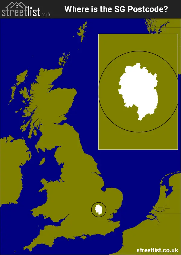
Where is the SG Postcode Area?
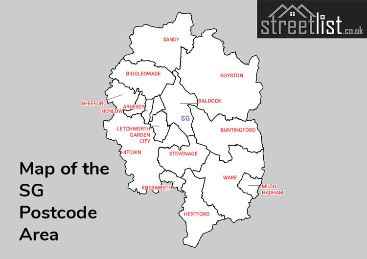
The SG postcode spans 34 miles at its widest and is just 14 miles north of central London at its nearest point.
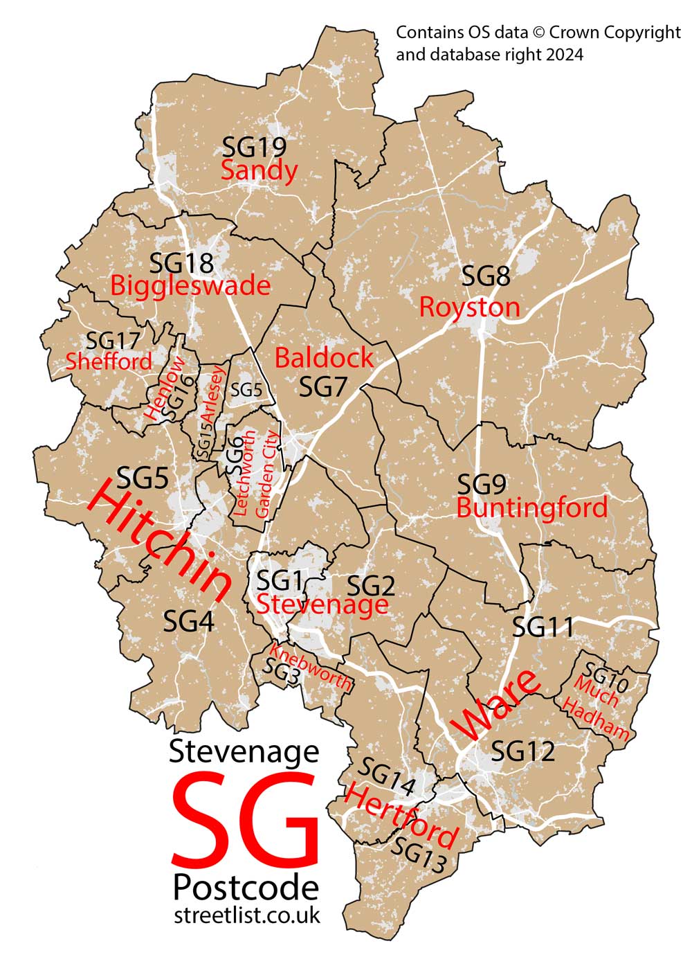
It covers parts of Hertfordshire, Bedfordshire and Cambridgeshire in the East of England and includes 19 districts.
Stevenage, Hertford, and Ware each have two districts in Hertfordshire, while Hitchin's two districts include both Hertfordshire and Bedfordshire. Letchworth Garden City, Buntingford, Knebworth, Baldock, and Much Hadham have districts within Hertfordshire.
Henlow, Shefford, Arlesey, and Biggleswade are located in Bedfordshire. Sandy is mainly Bedfordshire, with some areas in Cambridgeshire. Royston is divided between Cambridgeshire and Hertfordshire.
The SG Stevenage Postcode is in Eastern England. The postal area borders the following neighbouring postal areas: PE - Peterborough, CM - Chelmsford, CB - Cambridge, EN - Enfield, AL - St Albans, MK - Milton Keynes and LU - Luton, and is located inland.
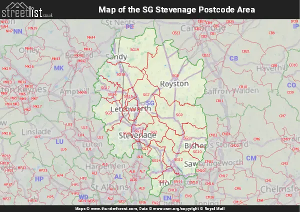
Map of the SG Stevenage Postcode Area
Explore the SG Stevenage postcode area by using our interactive map.
Postcode Districts within the SG Stevenage Postcode Area
There are 19 postcode districts within the Stevenage postcode area
A map showing the boundary of in relation to other areas
There are 14 towns within the Stevenage postcode area.
| Unit | Area² |
|---|---|
| Hectares | 1,299,185² |
| Miles | 5,016² |
| Feet | 139,842,974,215² |
| Kilometres | 12,992² |
Postal Delivery Offices serving the SG Stevenage Postcode Area
- Arlesey Scale Payment Delivery Office
- Ashwell Scale Payment Delivery Office
- Biggleswade Delivery Office
- Buntingford Scale Payment Delivery Office
- Codicote Scale Payment Delivery Office
- Gamlingay Scale Payment Delivery Office
- Henlow Camp Scale Payment Delivery Office
- Hertford Delivery Office
- Hitchin Delivery Office
- Kimpton Scale Payment Delivery Office
- Knebworth Scale Payment Delivery Office
- Langford Scale Payment Delivery Office
- Letchworth Delivery Office
- Offley Scale Payment Delivery Office
- Potton Scale Payment Delivery Office
- Royston Delivery Office
- Sandy Delivery Office
- Shefford Scale Payment Delivery Office
- Stevenage Delivery Office
- Stotfold Scale Payment Delivery Office
- Ware Delivery Office
- Weston Scale Payment Delivery Office
Councils with Postcodes in SG
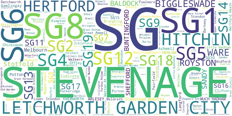
Towns and Villages within the SG Stevenage Postcode Area
- Abington Pigotts - village
- Albury - village
- Anstey - village
- Apsley End - village
- Ardeley - village
- Arlesey - village
- Arrington - village
- Ashwell - village
- Aspenden - village
- Aston - village
- Babbs Green - village
- Baldock - town
- Barkway - village
- Barley - village
- Barleycroft End - village
- Bassingbourn - village
- Bayford - village
- Beeston - village
- Benington - village
- Biggleswade - town
- Birch Green - village
- Blackmore End - village
- Bramfield - village
- Braughing - village
- Breachwood Green - village
- Brent Pelham - village
- Brickendon - village
- Broadoak End - village
- Broom - village
- Buckland - village
- Bull's Green - village
- Buntingford - town
- Burn's Green - village
- Bury Green - village
- Bygrave - village
- Campton - village
- Chapmore End - village
- Chicksands - village
- Chipping - village
- Chrishall - village
- Church End - village
- Clapgate - village
- Clifton - village
- Codicote - village
- Colliers End - village
- Cottered - village
- Crawley End - village
- Croydon - village
- Datchworth - village
- Dunton - village
- East Hatley - village
- Epping Green - village
- Everton - village
- Fowlmere - village
- Furneux Pelham - village
- Gamlingay - village
- Gamlingay Great Heath - village
- Gosmore - village
- Graveley - village
- Gravesend - village
- Great Amwell - village
- Great Chishill - village
- Great Gransden - village
- Great Hormead - village
- Great Offley - village
- Great Wymondley - village
- Green Tye - village
- Guilden Morden - village
- Hadham Cross - village
- Hailey - village
- Hare Street - village
- Hatley St George - village
- Haultwick - village
- Hay Green - village
- Henlow - village
- Hertford - town
- Hertford Heath - village
- Hertingfordbury - village
- Hexton - village
- Heydon - village
- High Cross - village
- Hinxworth - village
- Hitchin - town
- Hoddesdon - town
- Holwell - village
- Hunsdon - village
- Hunsdonbury - village
- Ickleford - village
- Ickwell - village
- Kelshall - village
- Kimpton - village
- Knebworth - village
- Kneesworth - village
- Langford - village
- Langley - village
- Letchworth - town
- Letty Green - village
- Litlington - village
- Little Berkhamsted - village
- Little Gransden - village
- Little Hadham - village
- Little Hormead - village
- Little Wymondley - village
- Lower Caldecote - village
- Lower Stondon - village
- Meesden - village
- Melbourn - village
- Meldreth - village
- Meppershall - village
- Much Hadham - village
- Newgate Street - village
- Newnham - village
- Northill - village
- Nuthampstead - village
- Old Knebworth - village
- Old Warden - village
- Old Wimpole - otherSettlement
- Orwell - village
- Patmore Heath - village
- Perry Green - village
- Pirton - village
- Potton - town
- Preston - village
- Puckeridge - village
- Rableyheath - village
- Radwell - village
- Reed - village
- Roe Green - village
- Royston - town
- Rushden - village
- Sacombe - village
- Sandon - village
- Sandy - town
- Shefford - town
- Shepreth - village
- Shillington - village
- South-end - village
- Southill - village
- St Ippolyts - village
- St Margarets - village
- Standon - village
- Stanford - village
- Stanstead Abbotts - village
- Stapleford - village
- Steeple Morden - village
- Stevenage - town
- Stocking Pelham - village
- Stotfold - town
- Sutton - village
- Tadlow - village
- Tempsford - village
- The Heath - village
- Therfield - village
- Thriplow - village
- Thundridge - village
- Tonwell - village
- Upper Caldecote - village
- Wadesmill - village
- Walkern - village
- Wallington - village
- Ware - town
- Wareside - village
- Waresley - village
- Waterford - village
- Watton at Stone - village
- Westmill - village
- Weston - village
- Whaddon - village
- Whitwell - village
- Widford - village
- Woolmer Green - village
- Wrestlingworth - village
- Wyddial - village