The CM0 postcode district is a postal district located in the CM Chelmsford postcode area with a population of 17,900 residents according to the 2021 England and Wales Census.
The area of the CM0 postcode district is 48.39 square miles which is 125.32 square kilometres or 30,967.75 acres.
Currently, the CM0 district has about 531 postcode units spread across 2 geographic postcode sectors.
Given that each sector allows for 400 unique postcode combinations, the district has a capacity of 800 postcodes. With 531 postcodes already in use, this leaves 269 units available.
The largest settlement in the CM0 postal code is BURNHAM-ON-CROUCH followed by SOUTHMINSTER, and St. Lawrence.
The postcode area has a boundary with Blackwater and Thames Estuary.
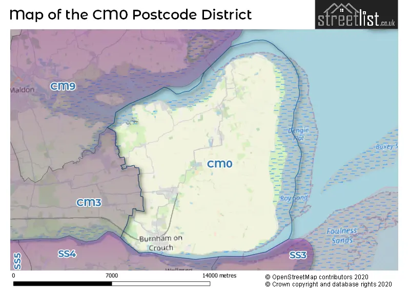
The CM0 Postcode shares a border with CM9 (MALDON, Heybridge, Tollesbury) and CM3 (South Woodham Ferrers, Danbury, Hatfield Peverel).
In the CM0 postcode district in Essex, the primary settlement is Southminster, which has the highest count of 119. Other significant settlements in the district include Asheldham, Bradwell-on-Sea, Dengie, St. Lawrence, Steeple, and Tillingham. The most significant post town in the district is Burnham-on-Crouch, with a count of 240.
For the district CM0, we have data on 2 postcode sectors. Here's a breakdown: The sector CM0 7, covers Southminster and Bradwell-On-Sea and Tillingham and St. Lawrence in Essex. The sector CM0 8, covers Burnham-On-Crouch in Essex.


Map of the CM0 Postcode District
Explore the CM0 postcode district by using our free interactive map.
When it comes to local government, postal geography often disregards political borders. However, for a breakdown in the CM0 District: the district mostly encompasses the Maldon District (B) area with a total of 555 postcodes.
Weather Forecast for CM0
Press Button to Show Forecast for Northend
| Time Period | Icon | Description | Temperature | Rain Probability | Wind |
|---|---|---|---|---|---|
| 12:00 to 15:00 | Overcast | 11.0°C (feels like 9.0°C) | 15.00% | ENE 11 mph | |
| 15:00 to 18:00 | Cloudy | 12.0°C (feels like 10.0°C) | 8.00% | ENE 11 mph | |
| 18:00 to 21:00 | Cloudy | 10.0°C (feels like 8.0°C) | 18.00% | ENE 11 mph | |
| 21:00 to 00:00 | Heavy rain | 10.0°C (feels like 7.0°C) | 88.00% | NE 13 mph |
Press Button to Show Forecast for Northend
| Time Period | Icon | Description | Temperature | Rain Probability | Wind |
|---|---|---|---|---|---|
| 00:00 to 03:00 | Heavy rain | 10.0°C (feels like 7.0°C) | 91.00% | NE 11 mph | |
| 03:00 to 06:00 | Heavy rain | 10.0°C (feels like 8.0°C) | 87.00% | E 9 mph | |
| 06:00 to 09:00 | Heavy rain | 10.0°C (feels like 7.0°C) | 83.00% | WSW 11 mph | |
| 09:00 to 12:00 | Heavy rain shower (day) | 11.0°C (feels like 8.0°C) | 64.00% | WSW 11 mph | |
| 12:00 to 15:00 | Heavy rain shower (day) | 11.0°C (feels like 8.0°C) | 60.00% | W 16 mph | |
| 15:00 to 18:00 | Cloudy | 11.0°C (feels like 8.0°C) | 20.00% | W 13 mph | |
| 18:00 to 21:00 | Cloudy | 10.0°C (feels like 8.0°C) | 12.00% | WSW 9 mph | |
| 21:00 to 00:00 | Partly cloudy (night) | 9.0°C (feels like 6.0°C) | 3.00% | SW 9 mph |
Press Button to Show Forecast for Northend
| Time Period | Icon | Description | Temperature | Rain Probability | Wind |
|---|---|---|---|---|---|
| 00:00 to 03:00 | Clear night | 7.0°C (feels like 5.0°C) | 3.00% | SW 7 mph | |
| 03:00 to 06:00 | Clear night | 6.0°C (feels like 3.0°C) | 2.00% | SSW 7 mph | |
| 06:00 to 09:00 | Sunny day | 7.0°C (feels like 5.0°C) | 1.00% | SSW 7 mph | |
| 09:00 to 12:00 | Sunny day | 12.0°C (feels like 10.0°C) | 1.00% | S 9 mph | |
| 12:00 to 15:00 | Partly cloudy (day) | 13.0°C (feels like 11.0°C) | 4.00% | SSE 11 mph | |
| 15:00 to 18:00 | Partly cloudy (day) | 14.0°C (feels like 11.0°C) | 2.00% | SSE 13 mph | |
| 18:00 to 21:00 | Sunny day | 13.0°C (feels like 11.0°C) | 1.00% | SSE 9 mph | |
| 21:00 to 00:00 | Clear night | 9.0°C (feels like 8.0°C) | 2.00% | SE 9 mph |
Press Button to Show Forecast for Northend
| Time Period | Icon | Description | Temperature | Rain Probability | Wind |
|---|---|---|---|---|---|
| 00:00 to 03:00 | Partly cloudy (night) | 9.0°C (feels like 7.0°C) | 2.00% | SE 9 mph | |
| 03:00 to 06:00 | Partly cloudy (night) | 8.0°C (feels like 6.0°C) | 4.00% | ESE 7 mph | |
| 06:00 to 09:00 | Cloudy | 10.0°C (feels like 8.0°C) | 8.00% | ESE 9 mph | |
| 09:00 to 12:00 | Cloudy | 13.0°C (feels like 11.0°C) | 8.00% | ESE 9 mph | |
| 12:00 to 15:00 | Cloudy | 14.0°C (feels like 12.0°C) | 11.00% | SE 9 mph | |
| 15:00 to 18:00 | Cloudy | 14.0°C (feels like 13.0°C) | 10.00% | ESE 11 mph | |
| 18:00 to 21:00 | Cloudy | 13.0°C (feels like 12.0°C) | 19.00% | E 9 mph | |
| 21:00 to 00:00 | Cloudy | 12.0°C (feels like 10.0°C) | 19.00% | E 9 mph |
Where is the CM0 Postcode District?
The postcode district for CM0 is in the town of Southminster. It is located near several nearby towns, including Burnham-on-Crouch to the south at a distance of 3.13 miles, Maldon to the northwest at a distance of 9.11 miles, Rochford to the southwest at a distance of 9.33 miles, and Clacton-on-Sea to the northeast at a distance of 13.78 miles. Additionally, Southminster is roughly 44.52 miles away from the centre of London.
The district covers the post towns of BURNHAM-ON-CROUCH, SOUTHMINSTER.
The sector has postcodes within the nation of England.
The CM0 Postcode District is in the Heart of Essex region of Essex within the East of England.
| Postcode Sector | Delivery Office |
|---|
| C | M | 0 | - | X | X | X |
| C | M | 0 | Space | Numeric | Letter | Letter |
Current Monthly Rental Prices
| # Bedrooms | Min Price | Max Price | Avg Price |
|---|---|---|---|
| £1,200 | £1,200 | £1,200 | |
| 1 | £695 | £695 | £695 |
| 2 | £1,400 | £1,400 | £1,400 |
| 4 | £1,800 | £1,800 | £1,800 |
Current House Prices
| # Bedrooms | Min Price | Max Price | Avg Price |
|---|---|---|---|
| 1 | £179,950 | £179,950 | £179,950 |
| 3 | £700,000 | £825,000 | £775,000 |
| 4 | £725,000 | £1,100,000 | £884,375 |
| 5 | £700,000 | £1,400,000 | £881,106 |
| 6 | £1,000,000 | £1,195,000 | £1,097,500 |
| 7 | £800,000 | £1,600,000 | £1,200,000 |
Estate Agents who Operate in the CM0 District
| Logo | Name | Brand Name | Address | Contact Number | Total Properties |
|---|---|---|---|---|---|
 | Burnham on Crouch | Church & Hawes | 156 Station Road, Burnham-On-Crouch, CM0 8HJ | 01621 731475 | 55 |
 | Burnham on Crouch | Bairstow Eves | 20 Station Road, Burnham on Crouch, Essex, CM0 8BQ | 01621 731481 | 38 |
 | Burnham-On-Crouch | S J Warren | 164 Station Road Burnham-On-Crouch CM0 8HJ | 01621 738592 | 33 |
 | Canvey Island - Sales | WilsonWood Properties Limited | 133 Furtherwick Road Canvey Island Essex SS8 7AT | 01268 203476 | 16 |
 | Latchingdon | Paul Mason Associates | 35 The Street, Latchingdon, CM3 6JP | 01621 738596 | 14 |
| Type of Property | 2018 Average | 2018 Sales | 2017 Average | 2017 Sales | 2016 Average | 2016 Sales | 2015 Average | 2015 Sales |
|---|---|---|---|---|---|---|---|---|
| Detached | £410,449 | 147 | £440,438 | 143 | £378,500 | 163 | £334,156 | 149 |
| Semi-Detached | £285,312 | 95 | £269,933 | 76 | £248,129 | 104 | £217,994 | 96 |
| Terraced | £253,172 | 83 | £244,798 | 72 | £215,584 | 95 | £198,672 | 79 |
| Flats | £156,229 | 26 | £148,352 | 27 | £128,919 | 36 | £111,152 | 28 |