The CO12 4 postcode sector is within the county of Essex.
Did you know? According to the 2021 Census, the CO12 4 postcode sector is home to a bustling 11,701 residents!
Given that each sector allows for 400 unique postcode combinations. Letters C, I, K, M, O and V are not allowed in the last two letters of a postcode. With 242 postcodes already in use, this leaves 158 units available.
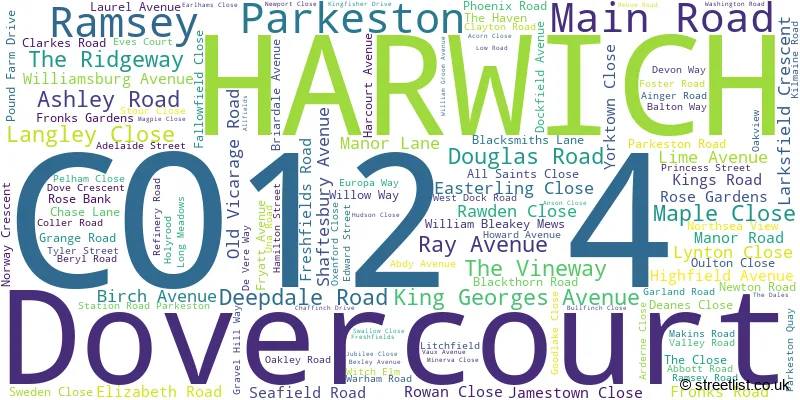
The largest settlement in the CO12 4 postal code is HARWICH followed by Dovercourt, and Ramsey.
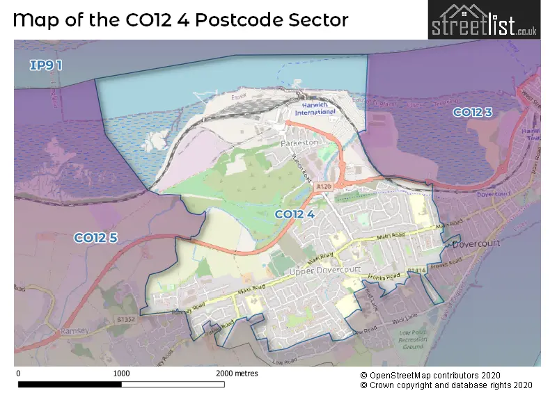
The CO12 4 Postcode shares a border with CO12 3 (HARWICH, Dovercourt) and CO12 5 (Ramsey, Great Oakley, Little Oakley).
The sector is within the post town of HARWICH.
CO12 4 is a postcode sector within the CO1 postcode district which is within the CO Colchester postcode area.
The Royal Mail delivery office for the CO12 4 postal sector is the unknown.
The area of the CO12 4 postcode sector is 1.96 square miles which is 5.08 square kilometres or 1,256.30 square acres.
The CO12 4 postcode sector is crossed by the A120 Major A road.

Map of the CO12 4 Postcode Sector
Explore the CO12 4 postcode sector by using our free interactive map.
| C | O | 1 | 2 | - | 4 | X | X |
| C | O | 1 | 2 | Space | 4 | Letter | Letter |
Official List of Streets
HARWICH (111 Streets)
Dovercourt (11 Streets)
Ramsey (1 Streets)
Unofficial Streets or Alternative Spellings
HARWICH
HALL LANE HERON WAY THE DRIVE CHASE COURT CHEVY COURT DEANES COURT DEANES LANE EARLHAMS MEWS EARLHEMS MEWS EAST DOCK ROAD ELM DRIVE HALFACRE LANE HANOVER COURT KINGS COURT NORTH SEA VIEW PARKESTON BYPASS PRINCES ROAD RAYHAVEN REBECCA CLOSE ROWLANDS YARD SAINT MICHAELS ROAD SQUAT LANE ST MICHAELS ROAD STATION ROAD THE ANCHORAGEDovercourt
REGIMENTAL WAYRamsey
RAMSEY ROAD RAY LANEWeather Forecast for CO12 4
Press Button to Show Forecast for Harwich
| Time Period | Icon | Description | Temperature | Rain Probability | Wind |
|---|---|---|---|---|---|
| 12:00 to 15:00 | Sunny day | 14.0°C (feels like 11.0°C) | 0.00% | S 18 mph | |
| 15:00 to 18:00 | Sunny day | 14.0°C (feels like 11.0°C) | 0.00% | S 18 mph | |
| 18:00 to 21:00 | Sunny day | 13.0°C (feels like 11.0°C) | 0.00% | S 13 mph | |
| 21:00 to 00:00 | Clear night | 11.0°C (feels like 9.0°C) | 0.00% | SSE 11 mph |
Press Button to Show Forecast for Harwich
| Time Period | Icon | Description | Temperature | Rain Probability | Wind |
|---|---|---|---|---|---|
| 00:00 to 03:00 | Clear night | 10.0°C (feels like 8.0°C) | 0.00% | SE 9 mph | |
| 03:00 to 06:00 | Partly cloudy (night) | 10.0°C (feels like 8.0°C) | 1.00% | SE 9 mph | |
| 06:00 to 09:00 | Sunny day | 11.0°C (feels like 9.0°C) | 1.00% | SE 9 mph | |
| 09:00 to 12:00 | Cloudy | 13.0°C (feels like 11.0°C) | 7.00% | SE 11 mph | |
| 12:00 to 15:00 | Cloudy | 13.0°C (feels like 11.0°C) | 7.00% | SE 11 mph | |
| 15:00 to 18:00 | Cloudy | 14.0°C (feels like 12.0°C) | 6.00% | SE 11 mph | |
| 18:00 to 21:00 | Cloudy | 13.0°C (feels like 12.0°C) | 18.00% | SE 9 mph | |
| 21:00 to 00:00 | Light rain | 12.0°C (feels like 10.0°C) | 57.00% | ESE 7 mph |
Press Button to Show Forecast for Harwich
| Time Period | Icon | Description | Temperature | Rain Probability | Wind |
|---|---|---|---|---|---|
| 00:00 to 03:00 | Overcast | 11.0°C (feels like 10.0°C) | 18.00% | SE 7 mph | |
| 03:00 to 06:00 | Mist | 10.0°C (feels like 10.0°C) | 22.00% | S 4 mph | |
| 06:00 to 09:00 | Cloudy | 11.0°C (feels like 10.0°C) | 9.00% | N 4 mph | |
| 09:00 to 12:00 | Cloudy | 14.0°C (feels like 13.0°C) | 9.00% | NE 7 mph | |
| 12:00 to 15:00 | Cloudy | 16.0°C (feels like 15.0°C) | 7.00% | E 9 mph | |
| 15:00 to 18:00 | Cloudy | 16.0°C (feels like 15.0°C) | 6.00% | E 9 mph | |
| 18:00 to 21:00 | Cloudy | 15.0°C (feels like 13.0°C) | 5.00% | NE 11 mph | |
| 21:00 to 00:00 | Overcast | 12.0°C (feels like 10.0°C) | 12.00% | N 13 mph |
Press Button to Show Forecast for Harwich
| Time Period | Icon | Description | Temperature | Rain Probability | Wind |
|---|---|---|---|---|---|
| 00:00 to 03:00 | Light rain shower (night) | 12.0°C (feels like 10.0°C) | 27.00% | NNW 11 mph | |
| 03:00 to 06:00 | Cloudy | 11.0°C (feels like 9.0°C) | 7.00% | NNW 11 mph | |
| 06:00 to 09:00 | Cloudy | 12.0°C (feels like 10.0°C) | 8.00% | NW 11 mph | |
| 09:00 to 12:00 | Partly cloudy (day) | 14.0°C (feels like 12.0°C) | 3.00% | NW 11 mph | |
| 12:00 to 15:00 | Partly cloudy (day) | 16.0°C (feels like 14.0°C) | 3.00% | NW 13 mph | |
| 15:00 to 18:00 | Partly cloudy (day) | 17.0°C (feels like 14.0°C) | 3.00% | NW 11 mph | |
| 18:00 to 21:00 | Sunny day | 15.0°C (feels like 13.0°C) | 3.00% | NW 11 mph | |
| 21:00 to 00:00 | Cloudy | 13.0°C (feels like 11.0°C) | 5.00% | NNW 11 mph |
Schools and Places of Education Within the CO12 4 Postcode Sector
All Saints' Church of England Voluntary Aided Primary School, Dovercourt
Voluntary aided school
Main Road, Harwich, Essex, CO12 4HT
Head: Mrs Samantha Moseley
Ofsted Rating: Good
Inspection: 2019-02-12 (1903 days ago)
Website: Visit All Saints' Church of England Voluntary Aided Primary School, Dovercourt Website
Phone: 01255502389
Number of Pupils: 191
Chase Lane Primary School and Nursery
Community school
Chase Lane, Harwich, Essex, CO12 4NB
Head: Mrs Julie O'Mara
Ofsted Rating: Good
Inspection: 2018-06-14 (2146 days ago)
Website: Visit Chase Lane Primary School and Nursery Website
Phone: 01255502416
Number of Pupils: 453
Spring Meadow Primary School & School House Nursery
Community school
Pound Farm Drive, Harwich, Essex, CO12 4LB
Head: Mrs Nicky Patrick
Ofsted Rating: Good
Inspection: 2018-04-24 (2197 days ago)
Website: Visit Spring Meadow Primary School & School House Nursery Website
Phone: 01255504528
Number of Pupils: 394
The Mayflower Primary School
Community school
Main Road, Harwich, Essex, CO12 4AJ
Head: Mrs Elizabeth Bartholomew
Ofsted Rating: Good
Inspection: 2022-02-25 (794 days ago)
Website: Visit The Mayflower Primary School Website
Phone: 01255502444
Number of Pupils: 338
House Prices in the CO12 4 Postcode Sector
| Type of Property | 2018 Average | 2018 Sales | 2017 Average | 2017 Sales | 2016 Average | 2016 Sales | 2015 Average | 2015 Sales |
|---|---|---|---|---|---|---|---|---|
| Detached | £251,810 | 42 | £258,732 | 56 | £223,167 | 51 | £233,421 | 38 |
| Semi-Detached | £197,080 | 79 | £180,229 | 102 | £162,664 | 85 | £154,986 | 80 |
| Terraced | £154,531 | 70 | £152,615 | 68 | £138,609 | 80 | £122,753 | 73 |
| Flats | £123,425 | 40 | £109,764 | 18 | £94,588 | 17 | £89,038 | 13 |
Important Postcodes CO12 4 in the Postcode Sector
CO12 4AH is the postcode for Adult Community Learning, Harwich Centre, and Tendring Adult Community College, Harwich Centre, Main Road
CO12 4AJ is the postcode for Adult Community Learning & Mayflower Primary School, Main Road
CO12 4EX is the postcode for North East Essex PCT, Fryatt Hospital & Mayflower Medical Centre, and Fryatt Hospital & Mayflower Medical Centre, 419 Main Road
CO12 4HT is the postcode for All Saints C of E Primary School, Main Road
CO12 4LB is the postcode for MAIN BUILDING, Spring Meadow Primary School, Pound Farm Drive
CO12 4NB is the postcode for MAIN BUILDING, Chase Lane Primary School and Nursery, Chase Lane
| The CO12 4 Sector is within these Local Authorities |
|
|---|---|
| The CO12 4 Sector is within these Counties |
|
| The CO12 4 Sector is within these Water Company Areas |
|