The CR0 2 postcode sector is within the county of Greater London.
Did you know? According to the 2021 Census, the CR0 2 postcode sector is home to a bustling 25,634 residents!
Given that each sector allows for 400 unique postcode combinations. Letters C, I, K, M, O and V are not allowed in the last two letters of a postcode. With 351 postcodes already in use, this leaves 49 units available.
The CR0 2 postal code covers the settlement of CROYDON .
The CR0 2 Postcode shares a border with SE25 6 (SOUTH NORWOOD ), CR0 6 (CROYDON ), SE25 5 (SOUTH NORWOOD ), CR0 1 (CROYDON ), CR0 3 (CROYDON , BEDDINGTON ), CR7 7 (THORNTON HEATH ) and CR7 8 (THORNTON HEATH , CROYDON ).
The sector is within the post town of CROYDON.
CR0 2 is a postcode sector within the CR0 postcode district which is within the CR Croydon postcode area.
The Royal Mail delivery office for the CR0 2 postal sector is the unknown.
The area of the CR0 2 postcode sector is 0.84 square miles which is 2.18 square kilometres or 538.31 square acres.

Map of the CR0 2 Postcode Sector
Explore the CR0 2 postcode sector by using our free interactive map.
| C | R | 0 | - | 2 | X | X |
| C | R | 0 | Space | 2 | Letter | Letter |
Official List of Streets
CROYDON (122 Streets)
Unofficial Streets or Alternative Spellings
Croydon
EDITH ROAD HOLMESDALE ROAD LONDON ROAD NEWHAVEN ROAD SAXON ROAD SELHURST PLACECROYDON
CANTERBURY ROAD CHATFIELD ROAD DENNETT ROAD FAIRHOLME ROAD GREENSIDE ROAD HANDCROFT ROAD LOWER ADDISCOMBE ROAD MEAD PLACE MIDHURST AVENUE MONTAGUE ROAD PEMDEVON ROAD POPLAR WALK SUMNER ROAD BIRD IN HAND PATH BISHOPS ROAD CHURCH ALLEY CROYDON UNDERPASS KIDDERMINSTER PLACE SCHOLARS PLACE ST MICHAELS ROAD TAIR ROAD WALPOLE ROAD WELLESLEY COURT ROAD WELLESLEY GROVE WELLESLEY PASSAGECROYDON,
BENSHAM LANE PITT ROAD WHITEHORSE ROADTHORNTON HEATH
ATTLEE CLOSE BENSHAM MANOR ROAD BERT ROAD FAIRGREEN ROAD KYNASTON AVENUE MAYDAY ROAD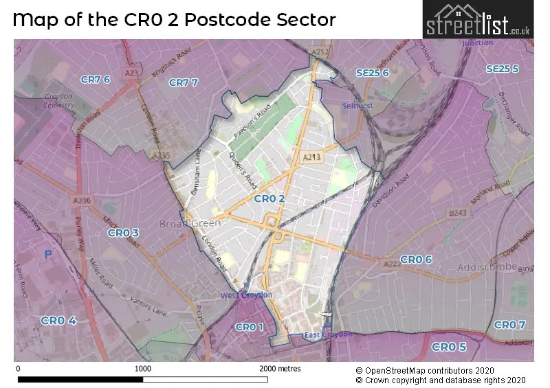
House Prices in the CR0 2 Postcode Sector
| Type of Property | 2018 Average | 2018 Sales | 2017 Average | 2017 Sales | 2016 Average | 2016 Sales | 2015 Average | 2015 Sales |
|---|---|---|---|---|---|---|---|---|
| Detached | £568,400 | 5 | £567,500 | 2 | £659,333 | 3 | £374,000 | 2 |
| Semi-Detached | £442,228 | 23 | £413,285 | 13 | £377,367 | 21 | £320,917 | 21 |
| Terraced | £337,857 | 51 | £334,121 | 75 | £330,650 | 80 | £283,687 | 67 |
| Flats | £265,965 | 198 | £344,245 | 496 | £277,917 | 554 | £240,124 | 278 |
Important Postcodes CR0 2 in the Postcode Sector
CR0 2AG is the postcode for The Home Office, Electric House, 3 Wellesley Road, and Electric House, 3 Wellesley Road
CR0 2AQ is the postcode for Trafalgar House, 1 Bedford Park, St. Marys Catholic Infant School, Bedford Park, and H M Land Registry, Trafalgar House, 1 Bedford Park
CR0 2BY is the postcode for London Borough of Croydon, 171 St. James's Road
CR0 2EA is the postcode for Broadmead Primary Academy, Sydenham Road, Broadmead Junior School, Sydenham Road, and BROADMEAD PRIMARY ACADEMY, SYDENHAM ROAD, CROYDON
CR0 2EW is the postcode for St Mary's Catholic Junior School, Sydenham Road, and St. Mary's RC Junior School, Sydenham Road
CR0 2HN is the postcode for ZONE 1, The Brit School, 60 The Crescent, MAIN BUILDING, The Brit School, 60 The Crescent, THE BLUE BLOCK, The Brit School, 60 The Crescent, ZONE 3, The Brit School, 60 The Crescent, EAST WING & EAST WING GYM BLOCK, The Brit School, 60 The Crescent, ZONE 2, The Brit School, 60 The Crescent, DEACON WING, The Brit School, 60 The Crescent, The Crescent Primary School, The Crescent, and MAIN BUILDING & DEACON WING, The Brit School, 60 The Crescent
CR0 2PD is the postcode for Broad Green Centre, 1-13 Lodge Road
CR0 2PL is the postcode for Elmwood Junior School, Lodge Road, Elmwood Infant and Nursery School, Lodge Road, BLOCK - A, Elmwood Junior & Infant School, Lodge Road, Elmwood Infant School, Lodge Road, and Elmwood Junior & Infant School, Lodge Road
CR0 2QT is the postcode for London Borough of Croydon, Access-Ability, 28 Boulogne Road
CR0 2RF is the postcode for Employment Tribunals, 101 London Road
CR0 2TB is the postcode for Harris Invictus Academy, London Road, and Harris Invictus Academy Croydon, London Road
CR0 2UR is the postcode for South London and Maudsley NHS Foundation Trust, Westways Resource Centre, Westway Resource Centre, 49 St. James's Road, and Chestnut Park Primary School, 49 St. James's Road
CR0 2WF is the postcode for HMRC - Croydon Regional Centre, 1 Ruskin Square
CR0 2XP is the postcode for Croydon Based Custody Centre, 90 Windmill Road
| The CR0 2 Sector is within these Local Authorities |
|
|---|---|
| The CR0 2 Sector is within these Counties |
|
| The CR0 2 Sector is within these Water Company Areas |
|