The CR3 7 postcode sector is within the county of Surrey.
Did you know? According to the 2021 Census, the CR3 7 postcode sector is home to a bustling 2,583 residents!
Given that each sector allows for 400 unique postcode combinations. Letters C, I, K, M, O and V are not allowed in the last two letters of a postcode. With 83 postcodes already in use, this leaves 317 units available.
The CR3 7 postal code covers the settlement of WOLDINGHAM .
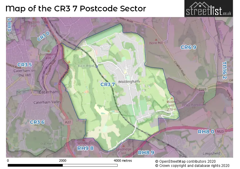
The CR3 7 Postcode shares a border with RH8 0 (LIMPSFIELD, OXTED, HURST GREEN), RH8 9 (OXTED, HURST GREEN, TANDRIDGE), RH9 8 (GODSTONE, South Godstone), CR3 0 (WHYTELEAFE ), CR3 6 (CATERHAM ) and CR6 9 (WARLINGHAM , CHELSHAM ).
The sector is within the post town of CATERHAM.
CR3 7 is a postcode sector within the CR3 postcode district which is within the CR Croydon postcode area.
The Royal Mail delivery office for the CR3 7 postal sector is the Caterham Delivery Office.
The area of the CR3 7 postcode sector is 4.93 square miles which is 12.78 square kilometres or 3,158.24 square acres.
The CR3 7 postcode sector is crossed by the M25 motorway.

Map of the CR3 7 Postcode Sector
Explore the CR3 7 postcode sector by using our free interactive map.
| C | R | 3 | - | 7 | X | X |
| C | R | 3 | Space | 7 | Letter | Letter |
Official List of Streets
Woldingham (33 Streets)
Unofficial Streets or Alternative Spellings
Schools and Places of Education Within the CR3 7 Postcode Sector
Woodlea Primary School
Academy converter
Long Hill, Caterham, Surrey, CR3 7EP
Head: Mrs Nina Gambier
Ofsted Rating: Good
Inspection: 2020-02-12 (1574 days ago)
Website: Visit Woodlea Primary School Website
Phone: 01883652358
Number of Pupils: 195
House Prices in the CR3 7 Postcode Sector
| Type of Property | 2018 Average | 2018 Sales | 2017 Average | 2017 Sales | 2016 Average | 2016 Sales | 2015 Average | 2015 Sales |
|---|---|---|---|---|---|---|---|---|
| Detached | £1,154,265 | 17 | £1,051,238 | 21 | £1,002,024 | 21 | £1,156,909 | 17 |
| Semi-Detached | £885,000 | 2 | £687,500 | 2 | £0 | 0 | £499,000 | 3 |
| Terraced | £0 | 0 | £423,750 | 2 | £586,750 | 2 | £0 | 0 |
| Flats | £0 | 0 | £435,000 | 1 | £0 | 0 | £417,500 | 1 |
Important Postcodes CR3 7 in the Postcode Sector
CR3 7EP is the postcode for JUNIOR BLOCK, Woodlea Primary School, Long Hill, and Woodlea Primary School, Long Hill
| The CR3 7 Sector is within these Local Authorities |
|
|---|---|
| The CR3 7 Sector is within these Counties |
|
| The CR3 7 Sector is within these Water Company Areas |
|