The CR3 postcode district is a postal district located in the CR Croydon postcode area with a population of 31,017 residents according to the 2021 England and Wales Census.
The area of the CR3 postcode district is 11.38 square miles which is 29.48 square kilometres or 7,285.13 acres.
Currently, the CR3 district has about 772 postcode units spread across 4 geographic postcode sectors.
Given that each sector allows for 400 unique postcode combinations, the district has a capacity of 1,600 postcodes. With 772 postcodes already in use, this leaves 828 units available.
The largest settlements in the CR3 postal code are CATERHAM and WHYTELEAFE.
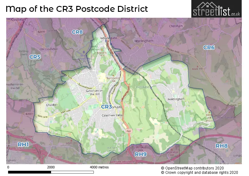
The CR3 Postcode shares a border with RH1 (REDHILL, MERSTHAM, BLETCHINGLEY), CR5 (COULSDON), CR6 (WARLINGHAM), RH8 (OXTED, HURST GREEN, LIMPSFIELD) and RH9 (GODSTONE, South Godstone).
The primary settlement in the CR3 postcode district is Whyteleafe, located in Greater London. The other significant settlements in this district include Caterham and Chaldon, both located in Surrey. The most significant post town in this district is Caterham.
For the district CR3, we have data on 5 postcode sectors. Here's a breakdown: The sector CR3 0, covers Whyteleafe in Surrey. The sector CR3 0, covers Whyteleafe in Greater London. The sector CR3 4 is non-geographic. It's often designated for PO Boxes, large organisations, or special services. The sector CR3 5, covers Caterham and Chaldon in Surrey. The sector CR3 6, covers Caterham in Surrey. The sector CR3 7, covers Woldingham in Surrey.

Map of the CR3 Postcode District
Explore the CR3 postcode district by using our free interactive map.
When it comes to local government, postal geography often disregards political borders. However, for a breakdown in the CR3 District: the district mostly encompasses the Tandridge District (752 postcodes), and finally, the Croydon London Boro area (21 postcodes).
Weather Forecast for CR3
Press Button to Show Forecast for Caterham
| Time Period | Icon | Description | Temperature | Rain Probability | Wind |
|---|---|---|---|---|---|
| 03:00 to 06:00 | Heavy rain | 6.0°C (feels like 3.0°C) | 77.00% | ENE 9 mph | |
| 06:00 to 09:00 | Drizzle | 6.0°C (feels like 3.0°C) | 46.00% | ENE 11 mph | |
| 09:00 to 12:00 | Cloudy | 8.0°C (feels like 6.0°C) | 47.00% | ENE 9 mph | |
| 12:00 to 15:00 | Light rain | 10.0°C (feels like 9.0°C) | 51.00% | NE 9 mph | |
| 15:00 to 18:00 | Cloudy | 12.0°C (feels like 10.0°C) | 12.00% | ENE 9 mph | |
| 18:00 to 21:00 | Light rain | 10.0°C (feels like 8.0°C) | 52.00% | ENE 9 mph | |
| 21:00 to 00:00 | Heavy rain | 9.0°C (feels like 6.0°C) | 89.00% | NE 11 mph |
Press Button to Show Forecast for Caterham
| Time Period | Icon | Description | Temperature | Rain Probability | Wind |
|---|---|---|---|---|---|
| 00:00 to 03:00 | Heavy rain | 8.0°C (feels like 6.0°C) | 90.00% | NE 11 mph | |
| 03:00 to 06:00 | Heavy rain | 8.0°C (feels like 6.0°C) | 90.00% | NE 9 mph | |
| 06:00 to 09:00 | Heavy rain | 8.0°C (feels like 6.0°C) | 86.00% | SSE 7 mph | |
| 09:00 to 12:00 | Heavy rain | 9.0°C (feels like 6.0°C) | 79.00% | W 11 mph | |
| 12:00 to 15:00 | Light rain | 9.0°C (feels like 6.0°C) | 56.00% | W 13 mph | |
| 15:00 to 18:00 | Light rain | 10.0°C (feels like 7.0°C) | 47.00% | W 11 mph | |
| 18:00 to 21:00 | Cloudy | 10.0°C (feels like 8.0°C) | 8.00% | WSW 9 mph | |
| 21:00 to 00:00 | Clear night | 7.0°C (feels like 5.0°C) | 4.00% | WSW 7 mph |
Press Button to Show Forecast for Caterham
| Time Period | Icon | Description | Temperature | Rain Probability | Wind |
|---|---|---|---|---|---|
| 00:00 to 03:00 | Clear night | 6.0°C (feels like 4.0°C) | 2.00% | SW 7 mph | |
| 03:00 to 06:00 | Clear night | 5.0°C (feels like 3.0°C) | 1.00% | SSW 7 mph | |
| 06:00 to 09:00 | Sunny day | 6.0°C (feels like 4.0°C) | 1.00% | S 7 mph | |
| 09:00 to 12:00 | Cloudy | 11.0°C (feels like 9.0°C) | 7.00% | S 9 mph | |
| 12:00 to 15:00 | Partly cloudy (day) | 13.0°C (feels like 11.0°C) | 5.00% | S 11 mph | |
| 15:00 to 18:00 | Partly cloudy (day) | 13.0°C (feels like 11.0°C) | 2.00% | S 11 mph | |
| 18:00 to 21:00 | Sunny day | 12.0°C (feels like 10.0°C) | 4.00% | S 9 mph | |
| 21:00 to 00:00 | Clear night | 8.0°C (feels like 6.0°C) | 1.00% | SE 7 mph |
Press Button to Show Forecast for Caterham
| Time Period | Icon | Description | Temperature | Rain Probability | Wind |
|---|---|---|---|---|---|
| 00:00 to 03:00 | Clear night | 8.0°C (feels like 6.0°C) | 1.00% | SE 9 mph | |
| 03:00 to 06:00 | Clear night | 7.0°C (feels like 5.0°C) | 4.00% | ESE 9 mph | |
| 06:00 to 09:00 | Sunny day | 8.0°C (feels like 6.0°C) | 6.00% | ESE 9 mph | |
| 09:00 to 12:00 | Cloudy | 13.0°C (feels like 11.0°C) | 7.00% | SE 9 mph | |
| 12:00 to 15:00 | Cloudy | 15.0°C (feels like 13.0°C) | 12.00% | SE 11 mph | |
| 15:00 to 18:00 | Cloudy | 15.0°C (feels like 13.0°C) | 11.00% | SE 9 mph | |
| 18:00 to 21:00 | Cloudy | 14.0°C (feels like 12.0°C) | 11.00% | SE 9 mph | |
| 21:00 to 00:00 | Cloudy | 11.0°C (feels like 10.0°C) | 9.00% | ESE 7 mph |
Where is the CR3 Postcode District?
The postcode district for CR3 is located in Caterham. This town is nearby other towns such as Woldingham to the east, Whyteleafe to the north, Chaldon to the west, Godstone to the south, Kenley to the northwest, and Warlingham to the northeast. Additionally, CR3 is approximately 15.69 miles away from the center of London.
The district covers the post towns of CATERHAM, WHYTELEAFE.
The sector has postcodes within the nation of England.
The CR3 Postcode District is covers the following regions.
- East Surrey - Surrey, East and West Sussex - South East (England)
- Croydon - Outer London - South - London
- Merton, Kingston upon Thames and Sutton - Outer London - South - London
- Bromley - Outer London - South - London
| Postcode Sector | Delivery Office |
|---|---|
| CR3 0 | Caterham Delivery Office |
| CR3 5 | Caterham Delivery Office |
| CR3 6 | Caterham Delivery Office |
| CR3 7 | Caterham Delivery Office |
| C | R | 3 | - | X | X | X |
| C | R | 3 | Space | Numeric | Letter | Letter |
Current Monthly Rental Prices
| # Bedrooms | Min Price | Max Price | Avg Price |
|---|---|---|---|
| £200 | £200 | £200 | |
| 1 | £900 | £1,300 | £1,153 |
| 2 | £1,300 | £1,800 | £1,545 |
| 3 | £1,995 | £2,500 | £2,332 |
| 4 | £2,450 | £3,950 | £2,879 |
| 5 | £3,750 | £4,350 | £4,150 |
Current House Prices
| # Bedrooms | Min Price | Max Price | Avg Price |
|---|---|---|---|
| £180,000 | £2,350,000 | £1,087,000 | |
| 1 | £70,000 | £300,000 | £170,680 |
| 2 | £110,000 | £530,000 | £300,453 |
| 3 | £270,000 | £1,750,000 | £555,573 |
| 4 | £245,000 | £2,250,000 | £847,213 |
| 5 | £396,500 | £3,000,000 | £1,150,052 |
| 6 | £1,100,000 | £2,250,000 | £1,675,000 |
Estate Agents who Operate in the CR3 District
| Logo | Name | Brand Name | Address | Contact Number | Total Properties |
|---|---|---|---|---|---|
 | Caterham | Bairstow Eves | 9 - 11 Station Avenue Caterham CR3 6LB | 01883 771097 | 66 |
 | Caterham | Hamptons Sales | 29 Station Avenue, Caterham, CR3 6LB | 01883 779609 | 37 |
 | Caterham | Cubitt & West | 53 Croydon Road, Caterham, Surrey, CR3 6PD | 01883 779599 | 33 |
 | Caterham, High Street | P . A . Jones Property Solutions | 79 High Street, Caterham, CR3 5UF | 01883 771246 | 30 |
 | Caterham on the Hill | Park & Bailey | 41 High Street, Caterham on the Hill, CR3 5UE | 01883 779626 | 26 |
| Type of Property | 2018 Average | 2018 Sales | 2017 Average | 2017 Sales | 2016 Average | 2016 Sales | 2015 Average | 2015 Sales |
|---|---|---|---|---|---|---|---|---|
| Detached | £766,800 | 120 | £724,648 | 146 | £691,037 | 150 | £647,848 | 216 |
| Semi-Detached | £423,890 | 150 | £424,961 | 148 | £412,713 | 145 | £396,979 | 161 |
| Terraced | £369,768 | 64 | £380,964 | 74 | £372,965 | 75 | £346,911 | 77 |
| Flats | £263,591 | 228 | £258,965 | 250 | £250,170 | 296 | £229,901 | 269 |