The CR5 postcode district is a postal district located in the CR Croydon postcode area with a population of 31,963 residents according to the 2021 England and Wales Census.
The area of the CR5 postcode district is 9.27 square miles which is 24.02 square kilometres or 5,935.30 acres.
Currently, the CR5 district has about 696 postcode units spread across 3 geographic postcode sectors.
Given that each sector allows for 400 unique postcode combinations, the district has a capacity of 1,200 postcodes. With 696 postcodes already in use, this leaves 504 units available.
The CR5 postal code covers the settlement of COULSDON.
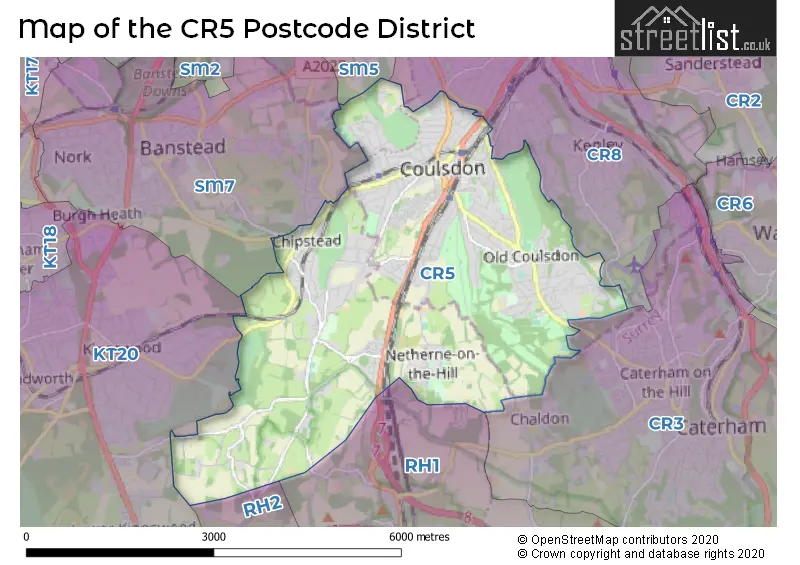
The CR5 Postcode shares a border with SM5 (CARSHALTON), KT20 (TADWORTH, KINGSWOOD, LOWER KINGSWOOD), RH1 (REDHILL, MERSTHAM, BLETCHINGLEY), CR3 (CATERHAM, WHYTELEAFE), CR8 (PURLEY, KENLEY) and SM7 (BANSTEAD, WOODMANSTERNE).
The primary settlement in the CR5 postcode district is Coulsdon, which is located in the county of Greater London. Additionally, there are significant settlements in Chipstead and Hooley, both located in the county of Surrey. Coulsdon is also the most significant post town in the CR5 postcode district.
For the district CR5, we have data on 4 postcode sectors. Here's a breakdown: The sector CR5 1, covers Coulsdon in Greater London. The sector CR5 1, covers Coulsdon in Surrey. The sector CR5 2, covers Coulsdon in Greater London. The sector CR5 3, covers Coulsdon in Greater London. The sector CR5 3, covers Chipstead in Surrey. The sector CR5 9 is non-geographic. It's often designated for PO Boxes, large organisations, or special services.


Map of the CR5 Postcode District
Explore the CR5 postcode district by using our free interactive map.
When it comes to local government, postal geography often disregards political borders. However, for a breakdown in the CR5 District: the district mostly encompasses the Croydon London Boro (525 postcodes), followed by the Reigate and Banstead District (B) area (140 postcodes), and finally, the Sutton London Boro area (37 postcodes).
Weather Forecast for CR5
Press Button to Show Forecast for Kenley
| Time Period | Icon | Description | Temperature | Rain Probability | Wind |
|---|---|---|---|---|---|
| 06:00 to 09:00 | Light rain | 6.0°C (feels like 3.0°C) | 47.00% | ENE 9 mph | |
| 09:00 to 12:00 | Overcast | 8.0°C (feels like 5.0°C) | 20.00% | ENE 9 mph | |
| 12:00 to 15:00 | Light rain | 10.0°C (feels like 8.0°C) | 52.00% | NE 9 mph | |
| 15:00 to 18:00 | Cloudy | 12.0°C (feels like 10.0°C) | 13.00% | ENE 9 mph | |
| 18:00 to 21:00 | Light rain | 10.0°C (feels like 8.0°C) | 51.00% | ENE 9 mph | |
| 21:00 to 00:00 | Heavy rain | 9.0°C (feels like 6.0°C) | 89.00% | NE 9 mph |
Press Button to Show Forecast for Kenley
| Time Period | Icon | Description | Temperature | Rain Probability | Wind |
|---|---|---|---|---|---|
| 00:00 to 03:00 | Heavy rain | 8.0°C (feels like 5.0°C) | 90.00% | NE 9 mph | |
| 03:00 to 06:00 | Heavy rain | 8.0°C (feels like 6.0°C) | 91.00% | NE 9 mph | |
| 06:00 to 09:00 | Heavy rain | 8.0°C (feels like 6.0°C) | 86.00% | NE 7 mph | |
| 09:00 to 12:00 | Heavy rain | 9.0°C (feels like 6.0°C) | 80.00% | W 11 mph | |
| 12:00 to 15:00 | Heavy rain | 9.0°C (feels like 6.0°C) | 77.00% | W 13 mph | |
| 15:00 to 18:00 | Light rain | 10.0°C (feels like 7.0°C) | 49.00% | W 11 mph | |
| 18:00 to 21:00 | Partly cloudy (day) | 10.0°C (feels like 8.0°C) | 5.00% | WSW 9 mph | |
| 21:00 to 00:00 | Clear night | 7.0°C (feels like 5.0°C) | 4.00% | WSW 7 mph |
Press Button to Show Forecast for Kenley
| Time Period | Icon | Description | Temperature | Rain Probability | Wind |
|---|---|---|---|---|---|
| 00:00 to 03:00 | Clear night | 6.0°C (feels like 4.0°C) | 2.00% | SW 7 mph | |
| 03:00 to 06:00 | Clear night | 5.0°C (feels like 3.0°C) | 1.00% | SSW 7 mph | |
| 06:00 to 09:00 | Sunny day | 7.0°C (feels like 4.0°C) | 1.00% | S 7 mph | |
| 09:00 to 12:00 | Cloudy | 11.0°C (feels like 9.0°C) | 6.00% | S 9 mph | |
| 12:00 to 15:00 | Partly cloudy (day) | 13.0°C (feels like 11.0°C) | 3.00% | S 11 mph | |
| 15:00 to 18:00 | Partly cloudy (day) | 13.0°C (feels like 11.0°C) | 4.00% | S 11 mph | |
| 18:00 to 21:00 | Sunny day | 12.0°C (feels like 10.0°C) | 4.00% | S 9 mph | |
| 21:00 to 00:00 | Clear night | 9.0°C (feels like 7.0°C) | 1.00% | SE 7 mph |
Press Button to Show Forecast for Kenley
| Time Period | Icon | Description | Temperature | Rain Probability | Wind |
|---|---|---|---|---|---|
| 00:00 to 03:00 | Clear night | 8.0°C (feels like 6.0°C) | 1.00% | SE 9 mph | |
| 03:00 to 06:00 | Clear night | 8.0°C (feels like 5.0°C) | 4.00% | ESE 7 mph | |
| 06:00 to 09:00 | Sunny day | 8.0°C (feels like 6.0°C) | 6.00% | ESE 9 mph | |
| 09:00 to 12:00 | Cloudy | 13.0°C (feels like 11.0°C) | 7.00% | SE 9 mph | |
| 12:00 to 15:00 | Cloudy | 15.0°C (feels like 13.0°C) | 12.00% | SE 11 mph | |
| 15:00 to 18:00 | Cloudy | 15.0°C (feels like 13.0°C) | 12.00% | SE 11 mph | |
| 18:00 to 21:00 | Cloudy | 14.0°C (feels like 12.0°C) | 11.00% | SE 9 mph | |
| 21:00 to 00:00 | Cloudy | 11.0°C (feels like 10.0°C) | 15.00% | ESE 7 mph |
Where is the CR5 Postcode District?
The postcode district for CR5 is located in COULSDON. This district is nearby various towns such as Hooley to the south (0.51 miles away), Chipstead to the southwest (1.46 miles away), The Mount to the north (1.70 miles away), Woodmansterne to the northwest (1.85 miles away), Chaldon to the southeast (1.97 miles away), Kenley to the northeast (2.37 miles away), and Kingswood to the west (2.51 miles away). Additionally, CR5 is approximately 14.24 miles away from the center of London.
The district is within the post town of COULSDON.
The sector has postcodes within the nation of England.
The CR5 Postcode District is covers the following regions.
- Croydon - Outer London - South - London
- East Surrey - Surrey, East and West Sussex - South East (England)
- Merton, Kingston upon Thames and Sutton - Outer London - South - London
| Postcode Sector | Delivery Office |
|---|---|
| CR5 1 | Coulsdon Delivery Office |
| CR5 2 | Coulsdon Delivery Office |
| CR5 3 | Coulsdon Delivery Office |
| C | R | 5 | - | X | X | X |
| C | R | 5 | Space | Numeric | Letter | Letter |
Current Monthly Rental Prices
| # Bedrooms | Min Price | Max Price | Avg Price |
|---|---|---|---|
| £1,000 | £1,000 | £1,000 | |
| 1 | £1,200 | £1,500 | £1,350 |
| 2 | £1,475 | £1,950 | £1,729 |
| 3 | £2,350 | £2,500 | £2,400 |
| 4 | £2,750 | £2,750 | £2,750 |
| 5 | £3,400 | £3,500 | £3,450 |
Current House Prices
| # Bedrooms | Min Price | Max Price | Avg Price |
|---|---|---|---|
| £135,000 | £450,000 | £251,650 | |
| 1 | £70,000 | £450,000 | £222,405 |
| 2 | £250,000 | £875,000 | £414,217 |
| 3 | £395,000 | £975,000 | £588,874 |
| 4 | £400,000 | £1,795,000 | £784,256 |
| 5 | £725,000 | £2,500,000 | £1,289,474 |
| 6 | £1,100,000 | £3,500,000 | £2,180,000 |
| 7 | £1,850,000 | £1,850,000 | £1,850,000 |
| 8 | £800,000 | £800,000 | £800,000 |
Estate Agents who Operate in the CR5 District
| Logo | Name | Brand Name | Address | Contact Number | Total Properties |
|---|---|---|---|---|---|
 | Coulsdon | Daniel Adams Estate Agents | 147 Brighton Road, Coulsdon, CR5 2NJ | 020 3872 6001 | 17 |
 | Coulsdon | Park & Bailey | 150-152 Brighton Road, Coulsdon, CR5 2YQ | 020 3869 5043 | 17 |
 | Old Coulsdon | John Brown Mark Youll | 105 Coulsdon Road, Coulsdon, CR5 1EH | 01737 302140 | 16 |
 | Coulsdon | Bond & Sherwill | 134 Brighton Road, Coulsdon, CR5 2ND | 020 3893 2304 | 11 |
 | Banstead | Richard Saunders and Company | 2 High Street, Banstead, Surrey, SM7 2LJ | 01737 302162 | 10 |
| Type of Property | 2018 Average | 2018 Sales | 2017 Average | 2017 Sales | 2016 Average | 2016 Sales | 2015 Average | 2015 Sales |
|---|---|---|---|---|---|---|---|---|
| Detached | £700,531 | 163 | £645,799 | 161 | £643,829 | 179 | £635,465 | 154 |
| Semi-Detached | £507,677 | 208 | £497,355 | 198 | £453,510 | 145 | £415,497 | 184 |
| Terraced | £386,643 | 94 | £397,114 | 93 | £382,693 | 92 | £333,315 | 96 |
| Flats | £282,705 | 98 | £254,228 | 80 | £265,806 | 78 | £259,041 | 102 |