The CR8 postcode district is a postal district located in the CR Croydon postcode area with a population of 33,370 residents according to the 2021 England and Wales Census.
The area of the CR8 postcode district is 5.17 square miles which is 13.38 square kilometres or 3,305.60 acres.
Currently, the CR8 district has about 762 postcode units spread across 5 geographic postcode sectors.
Given that each sector allows for 400 unique postcode combinations, the district has a capacity of 2,000 postcodes. With 762 postcodes already in use, this leaves 1238 units available.
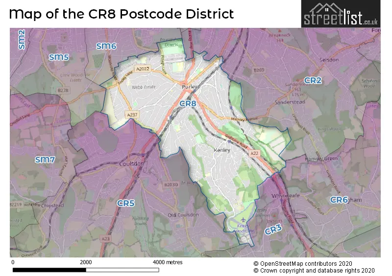
The largest settlements in the CR8 postal code are PURLEY and KENLEY.
The CR8 Postcode shares a border with CR2 (SOUTH CROYDON), SM5 (CARSHALTON), SM6 (WALLINGTON), CR5 (COULSDON) and CR6 (WARLINGHAM).
The primary settlement in the CR8 postcode district is Purley, located in the Greater London county. It has the highest count of postcodes, with a total of 112. Additionally, there are other significant settlements in the district, including Kenley, which is also in Greater London and has a count of 173 postcodes. There is another entry for Kenley in the CR8 5 sector, this time in Surrey, with a count of 11 postcodes. However, due to its small proportion of the data, Surrey will be omitted from the sentence. The most significant post town in the CR8 postcode district is Purley, with a count of 190 postcodes.
For the district CR8, we have data on 6 postcode sectors. Here's a breakdown: The sector CR8 1, covers Purley in Greater London. The sector CR8 2, covers Purley in Greater London. The sector CR8 3, covers Purley in Greater London. The sector CR8 4, covers Purley in Greater London. The sector CR8 5, covers Kenley in Greater London. The sector CR8 9 is non-geographic. It's often designated for PO Boxes, large organisations, or special services.


Map of the CR8 Postcode District
Explore the CR8 postcode district by using our free interactive map.
When it comes to local government, postal geography often disregards political borders. However, for a breakdown in the CR8 District: the district mostly encompasses the Croydon London Boro (749 postcodes), followed by the Sutton London Boro area (28 postcodes), and finally, the Tandridge District area (11 postcodes).
Weather Forecast for CR8
Press Button to Show Forecast for Kenley
| Time Period | Icon | Description | Temperature | Rain Probability | Wind |
|---|---|---|---|---|---|
| 00:00 to 03:00 | Cloudy | 6.0°C (feels like 3.0°C) | 8.00% | ENE 4 mph | |
| 03:00 to 06:00 | Cloudy | 5.0°C (feels like 2.0°C) | 7.00% | ENE 7 mph | |
| 06:00 to 09:00 | Cloudy | 5.0°C (feels like 2.0°C) | 8.00% | ENE 7 mph | |
| 09:00 to 12:00 | Cloudy | 7.0°C (feels like 4.0°C) | 7.00% | ENE 7 mph | |
| 12:00 to 15:00 | Overcast | 8.0°C (feels like 6.0°C) | 14.00% | E 9 mph | |
| 15:00 to 18:00 | Overcast | 9.0°C (feels like 7.0°C) | 17.00% | E 9 mph | |
| 18:00 to 21:00 | Cloudy | 8.0°C (feels like 6.0°C) | 14.00% | E 9 mph | |
| 21:00 to 00:00 | Cloudy | 7.0°C (feels like 4.0°C) | 13.00% | E 7 mph |
Press Button to Show Forecast for Kenley
| Time Period | Icon | Description | Temperature | Rain Probability | Wind |
|---|---|---|---|---|---|
| 00:00 to 03:00 | Cloudy | 6.0°C (feels like 3.0°C) | 16.00% | E 7 mph | |
| 03:00 to 06:00 | Light rain | 6.0°C (feels like 3.0°C) | 48.00% | ENE 9 mph | |
| 06:00 to 09:00 | Cloudy | 6.0°C (feels like 3.0°C) | 20.00% | ENE 9 mph | |
| 09:00 to 12:00 | Cloudy | 9.0°C (feels like 6.0°C) | 17.00% | E 9 mph | |
| 12:00 to 15:00 | Cloudy | 11.0°C (feels like 9.0°C) | 19.00% | E 11 mph | |
| 15:00 to 18:00 | Light rain shower (day) | 11.0°C (feels like 9.0°C) | 40.00% | E 11 mph | |
| 18:00 to 21:00 | Light rain | 10.0°C (feels like 8.0°C) | 54.00% | E 9 mph | |
| 21:00 to 00:00 | Light rain | 9.0°C (feels like 7.0°C) | 53.00% | ENE 9 mph |
Press Button to Show Forecast for Kenley
| Time Period | Icon | Description | Temperature | Rain Probability | Wind |
|---|---|---|---|---|---|
| 00:00 to 03:00 | Light rain | 9.0°C (feels like 6.0°C) | 53.00% | ENE 9 mph | |
| 03:00 to 06:00 | Light rain | 8.0°C (feels like 6.0°C) | 53.00% | ESE 9 mph | |
| 06:00 to 09:00 | Heavy rain shower (day) | 9.0°C (feels like 6.0°C) | 57.00% | ESE 9 mph | |
| 09:00 to 12:00 | Light rain shower (day) | 10.0°C (feels like 8.0°C) | 43.00% | SSE 11 mph | |
| 12:00 to 15:00 | Heavy rain shower (day) | 12.0°C (feels like 9.0°C) | 57.00% | SSE 13 mph | |
| 15:00 to 18:00 | Heavy rain shower (day) | 12.0°C (feels like 10.0°C) | 56.00% | SW 13 mph | |
| 18:00 to 21:00 | Light rain shower (day) | 11.0°C (feels like 9.0°C) | 36.00% | SW 9 mph | |
| 21:00 to 00:00 | Clear night | 9.0°C (feels like 7.0°C) | 8.00% | S 7 mph |
Where is the CR8 Postcode District?
The postcode district CR8 is located in Purley, which is a town in close proximity to several nearby towns. To the west, there is Coulsdon, which is approximately 0.51 miles away. To the north, there is Pampisford Road, which is about 1.13 miles away. In the south-east direction, there is Kenley, located approximately 1.13 miles away. In the north-west direction, there is Russell Hill, which is about 1.16 miles away. Lastly, in the north-east direction, there is Purley Oaks Road, located approximately 1.30 miles away. Additionally, Purley is approximately 12.37 miles away from the centre of London.
The district covers the post towns of KENLEY, PURLEY.
The sector has postcodes within the nation of England.
The CR8 Postcode District is covers the following regions.
- Croydon - Outer London - South - London
- Merton, Kingston upon Thames and Sutton - Outer London - South - London
- East Surrey - Surrey, East and West Sussex - South East (England)
| Postcode Sector | Delivery Office |
|---|---|
| CR8 1 | Purley Delivery Office |
| CR8 2 | Purley Delivery Office |
| CR8 3 | Purley Delivery Office |
| CR8 4 | Purley Delivery Office |
| CR8 5 | Purley Delivery Office |
| C | R | 8 | - | X | X | X |
| C | R | 8 | Space | Numeric | Letter | Letter |
Current Monthly Rental Prices
| # Bedrooms | Min Price | Max Price | Avg Price |
|---|---|---|---|
| £1,500 | £1,500 | £1,500 | |
| 1 | £750 | £1,450 | £1,178 |
| 2 | £1,350 | £3,300 | £1,998 |
| 3 | £1,895 | £3,000 | £2,418 |
| 4 | £2,900 | £4,500 | £3,660 |
| 5 | £3,000 | £3,600 | £3,325 |
| 6 | £13,000 | £13,000 | £13,000 |
Current House Prices
| # Bedrooms | Min Price | Max Price | Avg Price |
|---|---|---|---|
| £1 | £1,100,000 | £392,500 | |
| 1 | £90,000 | £450,000 | £260,256 |
| 2 | £90,000 | £670,000 | £376,172 |
| 3 | £307,500 | £950,000 | £566,189 |
| 4 | £340,500 | £1,650,000 | £794,471 |
| 5 | £650,000 | £1,400,000 | £1,012,857 |
| 6 | £660,500 | £2,695,000 | £1,262,318 |
| 7 | £2,000,000 | £2,850,000 | £2,425,000 |
| 8 | £4,000,000 | £4,000,000 | £4,000,000 |
| 18 | £3,500,000 | £3,500,000 | £3,500,000 |
Estate Agents who Operate in the CR8 District
| Logo | Name | Brand Name | Address | Contact Number | Total Properties |
|---|---|---|---|---|---|
 | Purley | Frost Estate Agents | 1 Purley Road, Purley, CR8 2HA | 020 8660 8228 | 62 |
 | Purley | Cubitt & West | 917 Brighton Road, Purley, Surrey, CR8 2BP | 020 3867 7006 | 40 |
 | Kenley | Bairstow Eves | 3 Station Approach, Hayes Lane, Kenley, Surrey, CR8 5JD | 020 3835 6056 | 21 |
 | Purley | Streets Ahead | 936 Brighton Road, Purley, CR8 2LP | 020 3873 6977 | 20 |
 | Purley | Bairstow Eves | 2-3 The Exchange Purley Road, Purley, Surrey CR8 2HA | 020 3835 5606 | 16 |
| Type of Property | 2018 Average | 2018 Sales | 2017 Average | 2017 Sales | 2016 Average | 2016 Sales | 2015 Average | 2015 Sales |
|---|---|---|---|---|---|---|---|---|
| Detached | £829,246 | 201 | £831,297 | 169 | £750,651 | 158 | £734,798 | 199 |
| Semi-Detached | £528,404 | 103 | £518,259 | 111 | £492,025 | 126 | £452,793 | 114 |
| Terraced | £408,975 | 65 | £416,398 | 46 | £390,709 | 77 | £344,275 | 82 |
| Flats | £292,300 | 192 | £284,386 | 163 | £268,177 | 167 | £232,043 | 204 |